| diagram | 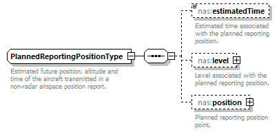 |
||
| namespace | http://www.fixm.aero/ext/nas/4.3 | ||
| children | nas:estimatedTime nas:level nas:position | ||
| used by |
|
||
| annotation |
|
||
| source | <xs:complexType name="PlannedReportingPositionType"> <xs:annotation> <xs:documentation>Estimated future position, altitude and time of the aircraft transmitted in a non-radar airspace position report.</xs:documentation> </xs:annotation> <xs:sequence> <xs:element name="estimatedTime" type="fb:TimeType" nillable="true" minOccurs="0" maxOccurs="1"> <xs:annotation> <xs:documentation>Estimated time associated with the planned reporting position.</xs:documentation> </xs:annotation> </xs:element> <xs:element name="level" type="fb:FlightLevelOrAltitudeChoiceType" nillable="true" minOccurs="0" maxOccurs="1"> <xs:annotation> <xs:documentation>Level associated with the planned reporting position.</xs:documentation> </xs:annotation> </xs:element> <xs:element name="position" type="fb:GeographicalPositionType" nillable="true" minOccurs="0" maxOccurs="1"> <xs:annotation> <xs:documentation>Planned reporting position point.</xs:documentation> </xs:annotation> </xs:element> </xs:sequence> </xs:complexType> |
element PlannedReportingPositionType/estimatedTime
| diagram | 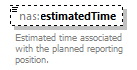 |
||||||||
| namespace | http://www.fixm.aero/ext/nas/4.3 | ||||||||
| type | fb:TimeType | ||||||||
| properties |
|
||||||||
| facets |
|
||||||||
| annotation |
|
||||||||
| source | <xs:element name="estimatedTime" type="fb:TimeType" nillable="true" minOccurs="0" maxOccurs="1"> <xs:annotation> <xs:documentation>Estimated time associated with the planned reporting position.</xs:documentation> </xs:annotation> </xs:element> |
element PlannedReportingPositionType/level
| diagram | 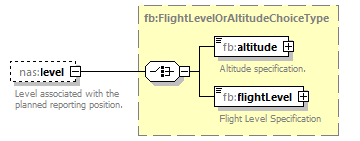 |
||||||||
| namespace | http://www.fixm.aero/ext/nas/4.3 | ||||||||
| type | fb:FlightLevelOrAltitudeChoiceType | ||||||||
| properties |
|
||||||||
| children | fb:altitude fb:flightLevel | ||||||||
| annotation |
|
||||||||
| source | <xs:element name="level" type="fb:FlightLevelOrAltitudeChoiceType" nillable="true" minOccurs="0" maxOccurs="1"> <xs:annotation> <xs:documentation>Level associated with the planned reporting position.</xs:documentation> </xs:annotation> </xs:element> |
element PlannedReportingPositionType/position
| diagram | 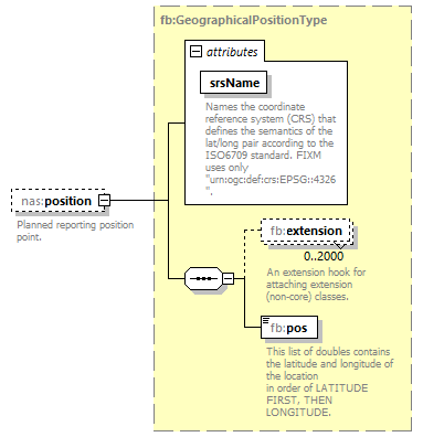 |
||||||||||||||
| namespace | http://www.fixm.aero/ext/nas/4.3 | ||||||||||||||
| type | fb:GeographicalPositionType | ||||||||||||||
| properties |
|
||||||||||||||
| children | fb:extension fb:pos | ||||||||||||||
| attributes |
|
||||||||||||||
| annotation |
|
||||||||||||||
| source | <xs:element name="position" type="fb:GeographicalPositionType" nillable="true" minOccurs="0" maxOccurs="1"> <xs:annotation> <xs:documentation>Planned reporting position point.</xs:documentation> </xs:annotation> </xs:element> |
XML Schema documentation generated by XMLSpy Schema Editor http://www.altova.com/xmlspy