Showing:

Annotations
Attributes
Diagrams
Facets
Instances
Properties
Source
Used by
Included schema Airspace.xsd
Namespace http://www.faa.aero/nas/4.2
Annotations
Copyright (c) 2017 Airservices Australia, DSNA, EUROCONTROL, GCAA UAE, IATA, 
       International Coordinating Council of Aerospace Industries Associations, JCAB, NATS 
       Limited, 
       NAV CANADA, SESAR Joint Undertaking & US FAA 
       =========================================== 
       All rights reserved. 
        
       Redistribution and use in source and binary forms, with or without modification, 
       are permitted provided that the 
       following conditions are met: 
* Redistributions of source code must retain the above copyright notice, this list of conditions and the disclaimer.
* Redistributions in binary form must reproduce the above copyright notice, this list of conditions
  and the disclaimer in the documentation and/or other materials provided with the distribution.
* Neither the names of Airservices Australia, DSNA, EUROCONTROL, GCAA UAE, IATA, International Coordinating 
  Council of Aerospace Industries Associations, JCAB, NATS Limited, NAV CANADA, SESAR Joint Undertaking & 
  US FAA nor the names of their contributors may be used to endorse or promote products derived from this
  specification without specific prior written permission.
        
       DISCLAIMER 
        
       THIS SPECIFICATION IS PROVIDED BY THE COPYRIGHT HOLDERS AND CONTRIBUTORS "AS IS" 
       AND ANY EXPRESS OR IMPLIED WARRANTIES, INCLUDING, BUT NOT LIMITED TO, THE IMPLIED 
       WARRANTIES OF MERCHANTABILITY AND FITNESS FOR A PARTICULAR PURPOSE ARE DISCLAIMED. 
       IN NO EVENT SHALL THE COPYRIGHT OWNER OR CONTRIBUTORS BE LIABLE FOR ANY DIRECT, INDIRECT, 
       INCIDENTAL, SPECIAL, EXEMPLARY, OR CONSEQUENTIAL DAMAGES (INCLUDING, BUT NOT LIMITED 
       TO, PROCUREMENT OF SUBSTITUTE GOODS OR SERVICES; LOSS OF USE, DATA, OR PROFITS; OR 
       BUSINESS INTERRUPTION) HOWEVER CAUSED AND ON ANY THEORY OF LIABILITY, WHETHER IN 
       CONTRACT, STRICT LIABILITY, OR TORT (INCLUDING NEGLIGENCE OR OTHERWISE) ARISING IN 
       ANY WAY OUT OF THE USE OF THIS SOFTWARE, EVEN IF ADVISED OF THE POSSIBILITY OF SUCH 
       DAMAGE. 
        
       ========================================== 
       Editorial note: this license is an instance of the BSD license template as provided 
       by the Open Source Initiative: 
       http://www.opensource.org/licenses/bsd-license.php 
        
       The authoritative reference for FIXM is www.FIXM.aero. 
        
       Details on Airservices Australia: http://www.airservicesaustralia.com/ 
       Details on DSNA: http://www.developpement-durable.gouv.fr/-Navigation-aerienne-.html 
       
       Details on EUROCONTROL: http://www.eurocontrol.int/ 
       Details on IATA: http://www.iata.org/Pages/default.aspx 
       Details on JCAB: http://www.mlit.go.jp/en/koku/index.html 
       Details on NATS Limited: http://www.nats.co.uk/ 
       Details on NAV CANADA: http://www.navcanada.ca/ 
       Details on the UAE GCAA: https://www.gcaa.gov.ae 
       Details on the ICCAIA: www.iccaia.org 
       Details on the SESAR JU and its members: http://www.sesarju.eu/discover-sesar/partnering-smarter-aviation/members 
       
       Details on the US FAA: http://www.faa.gov/
This package contains classes that model information about the airspace infrastructure 
(Airspace, ATS routes and Significant Points) needed by flight data. [FIXM]
Properties
attribute form default: unqualified
element form default: qualified
version: 4.1.0
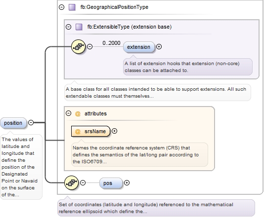
Element fb:DesignatedPointOrNavaidType / fb:position
Namespace http://www.fixm.aero/base/4.1
Annotations
The values of latitude and longitude that define the position of the Designated Point 
or Navaid on the surface of the Earth with respect to a reference datum. [specialised 
from ICAO Doc 9881] 
This optional field may be used as a complement of the designator in order to achieve 
unambiguous reference to the designated point or navaid. 
The combinations of fields that would make the reference unique are: 
- For designated points: designator + position 
- For navaids: designator + position + navaid service type
Diagram
Diagram Extension_xsd.tmp#ExtensibleType_extension Extension_xsd.tmp#ExtensibleType Airspace_xsd.tmp#GeographicalPositionType_srsName Airspace_xsd.tmp#GeographicalPositionType_pos Airspace_xsd.tmp#GeographicalPositionType
Type fb:GeographicalPositionType
Type hierarchy
Properties
content: complex
minOccurs: 0
maxOccurs: 1
Model fb:extension{0,2000} , fb:pos{0,1}
Children fb:extension, fb:pos
Instance
<fb:position srsName="urn:ogc:def:crs:EPSG::4326">
  <fb:extension>{0,2000}</fb:extension>
  <fb:pos>{0,1}</fb:pos>
</fb:position>
Attributes
QName Type Fixed Default Use Annotation
srsName string urn:ogc:def:crs:EPSG::4326 required
Names the coordinate reference system (CRS) that defines the semantics of the 
lat/long pair according to the ISO6709 standard. FIXM uses only "urn:ogc:def:crs:EPSG::4326".
Source
<element name="position" type="fb:GeographicalPositionType" minOccurs="0" maxOccurs="1">
  <annotation>
    <documentation>The values of latitude and longitude that define the position of the Designated Point or Navaid on the surface of the Earth with respect to a reference datum. [specialised from ICAO Doc 9881] This optional field may be used as a complement of the designator in order to achieve unambiguous reference to the designated point or navaid. The combinations of fields that would make the reference unique are: - For designated points: designator + position - For navaids: designator + position + navaid service type</documentation>
  </annotation>
</element>
Element fb:GeographicalPositionType / fb:pos
Namespace http://www.fixm.aero/base/4.1
Diagram
Diagram
Type restriction of list of double
Type hierarchy
  • double
Properties
content: simple
minOccurs: 0
maxOccurs: 1
Facets
length 2
Source
<element name="pos" minOccurs="0" maxOccurs="1">
  <simpleType>
    <restriction>
      <simpleType>
        <list itemType="double"/>
      </simpleType>
      <length value="2"/>
    </restriction>
  </simpleType>
</element>
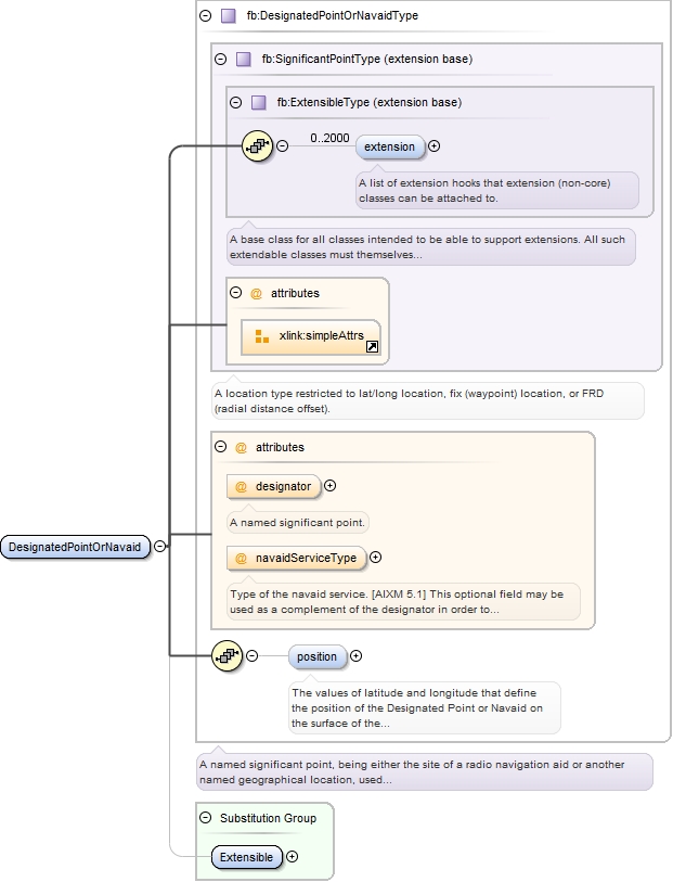
Element fb:DesignatedPointOrNavaid
Namespace http://www.fixm.aero/base/4.1
Diagram
Diagram Extension_xsd.tmp#ExtensibleType_extension Extension_xsd.tmp#ExtensibleType Airspace_xsd.tmp#SignificantPointType Airspace_xsd.tmp#DesignatedPointOrNavaidType_designator Airspace_xsd.tmp#DesignatedPointOrNavaidType_navaidServiceType Airspace_xsd.tmp#DesignatedPointOrNavaidType_position Airspace_xsd.tmp#DesignatedPointOrNavaidType Extension_xsd.tmp#Extensible
Type fb:DesignatedPointOrNavaidType
Type hierarchy
Properties
content: complex
Substitution Group Affiliation
Model fb:extension{0,2000} , fb:position{0,1}
Children fb:extension, fb:position
Instance
<fb:DesignatedPointOrNavaid designator="" navaidServiceType="">
  <fb:extension>{0,2000}</fb:extension>
  <fb:position srsName="urn:ogc:def:crs:EPSG::4326">{0,1}</fb:position>
</fb:DesignatedPointOrNavaid>
Attributes
QName Type Fixed Default Use Annotation
designator fb:SignificantPointDesignatorType optional
A named significant point.
navaidServiceType fb:NavaidServiceTypeType optional
Type of the navaid service. [AIXM 5.1] 
This optional field may be used as a complement of the designator in order to achieve 
unambiguous reference to the navaid. 
The combinations of fields that would make the reference unique are: 
- For navaids: designator + position + navaid service type
Source
<element name="DesignatedPointOrNavaid" type="fb:DesignatedPointOrNavaidType" substitutionGroup="fb:Extensible"/>
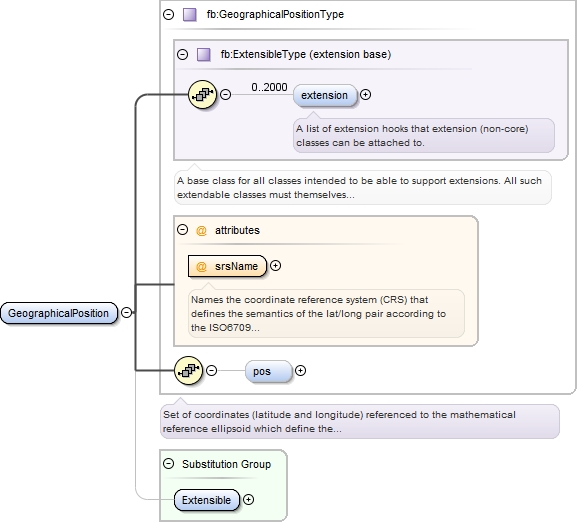
Element fb:GeographicalPosition
Namespace http://www.fixm.aero/base/4.1
Diagram
Diagram Extension_xsd.tmp#ExtensibleType_extension Extension_xsd.tmp#ExtensibleType Airspace_xsd.tmp#GeographicalPositionType_srsName Airspace_xsd.tmp#GeographicalPositionType_pos Airspace_xsd.tmp#GeographicalPositionType Extension_xsd.tmp#Extensible
Type fb:GeographicalPositionType
Type hierarchy
Properties
content: complex
Substitution Group Affiliation
Model fb:extension{0,2000} , fb:pos{0,1}
Children fb:extension, fb:pos
Instance
<fb:GeographicalPosition srsName="urn:ogc:def:crs:EPSG::4326">
  <fb:extension>{0,2000}</fb:extension>
  <fb:pos>{0,1}</fb:pos>
</fb:GeographicalPosition>
Attributes
QName Type Fixed Default Use Annotation
srsName string urn:ogc:def:crs:EPSG::4326 required
Names the coordinate reference system (CRS) that defines the semantics of the 
lat/long pair according to the ISO6709 standard. FIXM uses only "urn:ogc:def:crs:EPSG::4326".
Source
<element name="GeographicalPosition" type="fb:GeographicalPositionType" substitutionGroup="fb:Extensible"/>
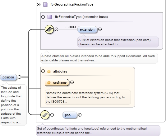
Element fb:PositionPointType / fb:position
Namespace http://www.fixm.aero/base/4.1
Annotations
The values of latitude and longitude that define the position of a point on the surface 
of the Earth with respect to a reference datum. [specialised from ICAO Doc 9881]
Diagram
Diagram Extension_xsd.tmp#ExtensibleType_extension Extension_xsd.tmp#ExtensibleType Airspace_xsd.tmp#GeographicalPositionType_srsName Airspace_xsd.tmp#GeographicalPositionType_pos Airspace_xsd.tmp#GeographicalPositionType
Type fb:GeographicalPositionType
Type hierarchy
Properties
content: complex
minOccurs: 0
maxOccurs: 1
Model fb:extension{0,2000} , fb:pos{0,1}
Children fb:extension, fb:pos
Instance
<fb:position srsName="urn:ogc:def:crs:EPSG::4326">
  <fb:extension>{0,2000}</fb:extension>
  <fb:pos>{0,1}</fb:pos>
</fb:position>
Attributes
QName Type Fixed Default Use Annotation
srsName string urn:ogc:def:crs:EPSG::4326 required
Names the coordinate reference system (CRS) that defines the semantics of the 
lat/long pair according to the ISO6709 standard. FIXM uses only "urn:ogc:def:crs:EPSG::4326".
Source
<element name="position" type="fb:GeographicalPositionType" minOccurs="0" maxOccurs="1">
  <annotation>
    <documentation>The values of latitude and longitude that define the position of a point on the surface of the Earth with respect to a reference datum. [specialised from ICAO Doc 9881]</documentation>
  </annotation>
</element>
Element fb:PositionPoint
Namespace http://www.fixm.aero/base/4.1
Diagram
Diagram Extension_xsd.tmp#ExtensibleType_extension Extension_xsd.tmp#ExtensibleType Airspace_xsd.tmp#SignificantPointType Airspace_xsd.tmp#PositionPointType_position Airspace_xsd.tmp#PositionPointType Extension_xsd.tmp#Extensible
Type fb:PositionPointType
Type hierarchy
Properties
content: complex
Substitution Group Affiliation
Model fb:extension{0,2000} , fb:position{0,1}
Children fb:extension, fb:position
Instance
<fb:PositionPoint>
  <fb:extension>{0,2000}</fb:extension>
  <fb:position srsName="urn:ogc:def:crs:EPSG::4326">{0,1}</fb:position>
</fb:PositionPoint>
Source
<element name="PositionPoint" type="fb:PositionPointType" substitutionGroup="fb:Extensible"/>
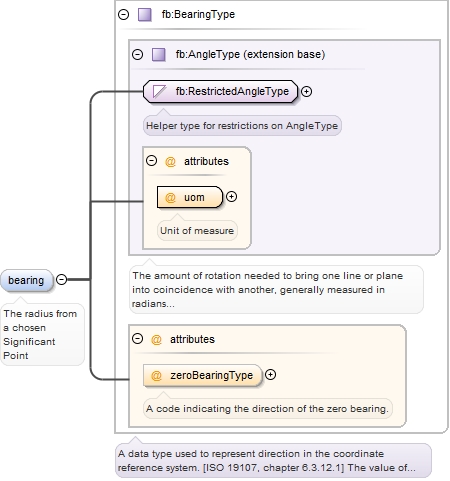
Element fb:RelativePointType / fb:bearing
Namespace http://www.fixm.aero/base/4.1
Annotations
The radius from a chosen Significant Point
Diagram
Diagram Measures_xsd.tmp#RestrictedAngleType Measures_xsd.tmp#AngleType_uom Measures_xsd.tmp#AngleType Measures_xsd.tmp#BearingType_zeroBearingType Measures_xsd.tmp#BearingType
Type fb:BearingType
Type hierarchy
Properties
content: complex
minOccurs: 0
maxOccurs: 1
Attributes
QName Type Fixed Default Use Annotation
uom fb:UomAngleType required
Unit of measure
zeroBearingType fb:ZeroBearingTypeType optional
A code indicating the direction of the zero bearing.
Source
<element name="bearing" type="fb:BearingType" minOccurs="0" maxOccurs="1">
  <annotation>
    <documentation>The radius from a chosen Significant Point</documentation>
  </annotation>
</element>
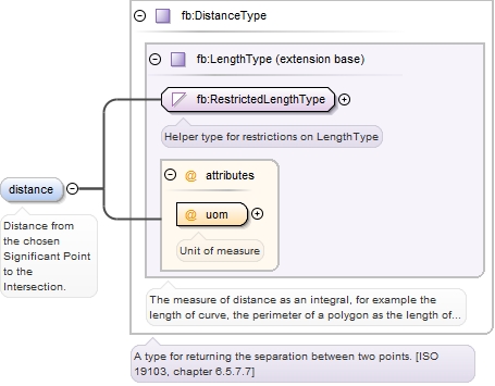
Element fb:RelativePointType / fb:distance
Namespace http://www.fixm.aero/base/4.1
Annotations
Distance from the chosen Significant Point to the Intersection.
Diagram
Diagram Measures_xsd.tmp#RestrictedLengthType Measures_xsd.tmp#LengthType_uom Measures_xsd.tmp#LengthType Measures_xsd.tmp#DistanceType
Type fb:DistanceType
Type hierarchy
Properties
content: complex
minOccurs: 0
maxOccurs: 1
Attributes
QName Type Fixed Default Use Annotation
uom fb:UomLengthType required
Unit of measure
Source
<element name="distance" type="fb:DistanceType" minOccurs="0" maxOccurs="1">
  <annotation>
    <documentation>Distance from the chosen Significant Point to the Intersection.</documentation>
  </annotation>
</element>
Element fb:RelativePointType / fb:position
Namespace http://www.fixm.aero/base/4.1
Annotations
The values of latitude and longitude that define the position of the Relative Point 
on the surface of the Earth with respect to a reference datum. [specialised from 
ICAO Doc 9881] 
 
This optional field may be used to provide the actual position of the relative point 
if already known / computed.
Diagram
Diagram Extension_xsd.tmp#ExtensibleType_extension Extension_xsd.tmp#ExtensibleType Airspace_xsd.tmp#GeographicalPositionType_srsName Airspace_xsd.tmp#GeographicalPositionType_pos Airspace_xsd.tmp#GeographicalPositionType
Type fb:GeographicalPositionType
Type hierarchy
Properties
content: complex
minOccurs: 0
maxOccurs: 1
Model fb:extension{0,2000} , fb:pos{0,1}
Children fb:extension, fb:pos
Instance
<fb:position srsName="urn:ogc:def:crs:EPSG::4326">
  <fb:extension>{0,2000}</fb:extension>
  <fb:pos>{0,1}</fb:pos>
</fb:position>
Attributes
QName Type Fixed Default Use Annotation
srsName string urn:ogc:def:crs:EPSG::4326 required
Names the coordinate reference system (CRS) that defines the semantics of the 
lat/long pair according to the ISO6709 standard. FIXM uses only "urn:ogc:def:crs:EPSG::4326".
Source
<element name="position" type="fb:GeographicalPositionType" minOccurs="0" maxOccurs="1">
  <annotation>
    <documentation>The values of latitude and longitude that define the position of the Relative Point on the surface of the Earth with respect to a reference datum. [specialised from ICAO Doc 9881] This optional field may be used to provide the actual position of the relative point if already known / computed.</documentation>
  </annotation>
</element>
Element fb:RelativePointType / fb:referencePoint
Namespace http://www.fixm.aero/base/4.1
Annotations
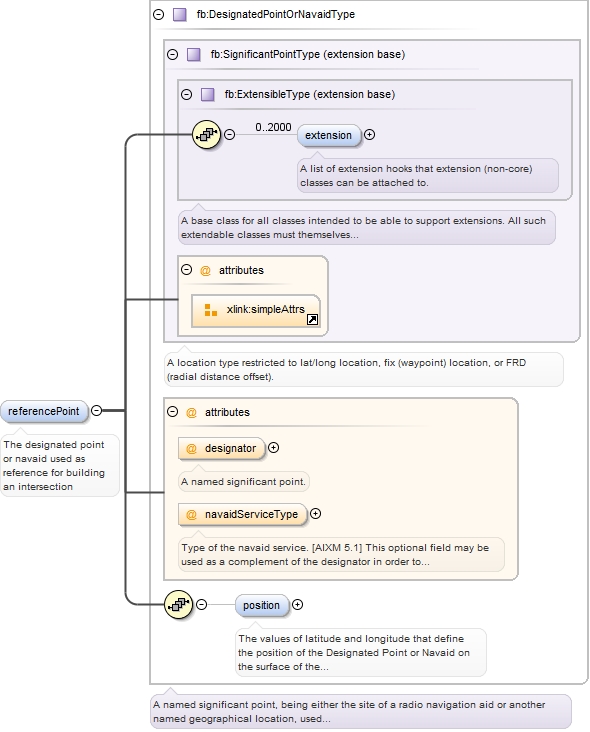
The designated point or navaid used as reference for building an intersection
Diagram
Diagram Extension_xsd.tmp#ExtensibleType_extension Extension_xsd.tmp#ExtensibleType Airspace_xsd.tmp#SignificantPointType Airspace_xsd.tmp#DesignatedPointOrNavaidType_designator Airspace_xsd.tmp#DesignatedPointOrNavaidType_navaidServiceType Airspace_xsd.tmp#DesignatedPointOrNavaidType_position Airspace_xsd.tmp#DesignatedPointOrNavaidType
Type fb:DesignatedPointOrNavaidType
Type hierarchy
Properties
content: complex
minOccurs: 0
maxOccurs: 1
Model fb:extension{0,2000} , fb:position{0,1}
Children fb:extension, fb:position
Instance
<fb:referencePoint designator="" navaidServiceType="">
  <fb:extension>{0,2000}</fb:extension>
  <fb:position srsName="urn:ogc:def:crs:EPSG::4326">{0,1}</fb:position>
</fb:referencePoint>
Attributes
QName Type Fixed Default Use Annotation
designator fb:SignificantPointDesignatorType optional
A named significant point.
navaidServiceType fb:NavaidServiceTypeType optional
Type of the navaid service. [AIXM 5.1] 
This optional field may be used as a complement of the designator in order to achieve 
unambiguous reference to the navaid. 
The combinations of fields that would make the reference unique are: 
- For navaids: designator + position + navaid service type
Source
<element name="referencePoint" type="fb:DesignatedPointOrNavaidType" minOccurs="0" maxOccurs="1">
  <annotation>
    <documentation>The designated point or navaid used as reference for building an intersection</documentation>
  </annotation>
</element>
Element fb:RelativePoint
Namespace http://www.fixm.aero/base/4.1
Diagram
Diagram Extension_xsd.tmp#ExtensibleType_extension Extension_xsd.tmp#ExtensibleType Airspace_xsd.tmp#SignificantPointType Airspace_xsd.tmp#RelativePointType_bearing Airspace_xsd.tmp#RelativePointType_distance Airspace_xsd.tmp#RelativePointType_position Airspace_xsd.tmp#RelativePointType_referencePoint Airspace_xsd.tmp#RelativePointType Extension_xsd.tmp#Extensible
Type fb:RelativePointType
Type hierarchy
Properties
content: complex
Substitution Group Affiliation
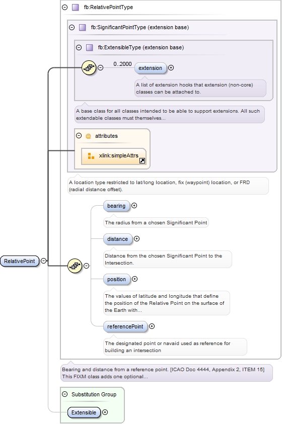
Model fb:extension{0,2000} , fb:bearing{0,1} , fb:distance{0,1} , fb:position{0,1} , fb:referencePoint{0,1}
Children fb:bearing, fb:distance, fb:extension, fb:position, fb:referencePoint
Instance
<fb:RelativePoint>
  <fb:extension>{0,2000}</fb:extension>
  <fb:bearing uom="" zeroBearingType="">{0,1}</fb:bearing>
  <fb:distance uom="">{0,1}</fb:distance>
  <fb:position srsName="urn:ogc:def:crs:EPSG::4326">{0,1}</fb:position>
  <fb:referencePoint designator="" navaidServiceType="">{0,1}</fb:referencePoint>
</fb:RelativePoint>
Source
<element name="RelativePoint" type="fb:RelativePointType" substitutionGroup="fb:Extensible"/>
Element fb:SignificantPoint
Namespace http://www.fixm.aero/base/4.1
Diagram
Diagram Extension_xsd.tmp#ExtensibleType_extension Extension_xsd.tmp#ExtensibleType Airspace_xsd.tmp#SignificantPointType Extension_xsd.tmp#Extensible
Type fb:SignificantPointType
Type hierarchy
Properties
content: complex
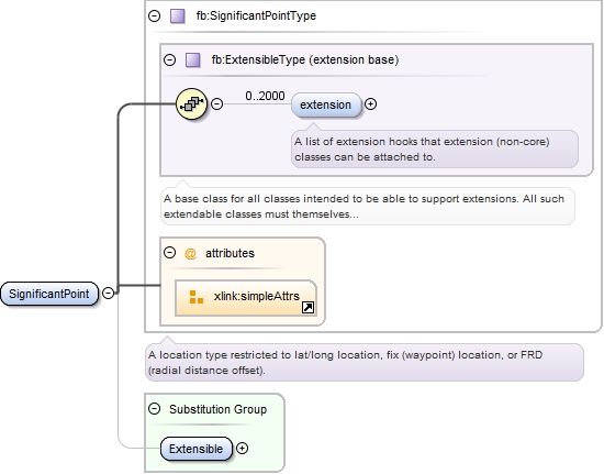
Substitution Group Affiliation
Model fb:extension{0,2000}
Children fb:extension
Instance
<fb:SignificantPoint>
  <fb:extension>{0,2000}</fb:extension>
</fb:SignificantPoint>
Source
<element name="SignificantPoint" type="fb:SignificantPointType" substitutionGroup="fb:Extensible"/>
Complex Type fb:SignificantPointType
Namespace http://www.fixm.aero/base/4.1
Annotations
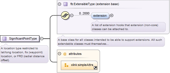
A location type restricted to lat/long location, fix (waypoint) location, or FRD 
(radial distance offset).
Diagram
Diagram Extension_xsd.tmp#ExtensibleType_extension Extension_xsd.tmp#ExtensibleType
Type extension of fb:ExtensibleType
Type hierarchy
Properties
abstract: true
Used by
Model fb:extension{0,2000}
Children fb:extension
Source
<complexType abstract="true" name="SignificantPointType">
  <annotation>
    <documentation>A location type restricted to lat/long location, fix (waypoint) location, or FRD (radial distance offset).</documentation>
  </annotation>
  <complexContent>
    <extension base="fb:ExtensibleType">
      <attributeGroup ref="xlink:simpleAttrs"/>
    </extension>
  </complexContent>
</complexType>
Simple Type fb:AirspaceDesignatorType
Namespace http://www.fixm.aero/base/4.1
Annotations
A published sequence of characters allowing the identification of the airspace. [AIXM 
5.1]
Diagram
Diagram Types_xsd.tmp#CharacterStringType
Type restriction of fb:CharacterStringType
Type hierarchy
Facets
minLength 1
maxLength 10
pattern ([A-Z]|[0-9]|[, !"&amp;#$%'\(\)\*\+\-\./:;&lt;=&gt;\?@\[\\\]\^_\|\{\}])*
Used by
Source
<simpleType name="AirspaceDesignatorType">
  <annotation>
    <documentation>A published sequence of characters allowing the identification of the airspace. [AIXM 5.1]</documentation>
  </annotation>
  <restriction base="fb:CharacterStringType">
    <pattern value="([A-Z]|[0-9]|[, !"&amp;#$%'\(\)\*\+\-\./:;&lt;=&gt;\?@\[\\\]\^_\|\{\}])*"/>
    <minLength value="1"/>
    <maxLength value="10"/>
  </restriction>
</simpleType>
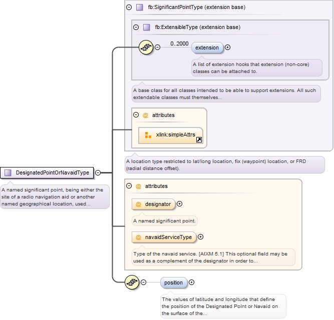
Complex Type fb:DesignatedPointOrNavaidType
Namespace http://www.fixm.aero/base/4.1
Annotations
A named significant point, being either the site of a radio navigation aid or another 
named geographical location, used in defining an ATS route, the flight path of an 
aircraft or for other navigation or ATS purposes. [FIXM] 
 
The coded designator of a navaid or designated point is not always sufficient for 
unambiguously referring to that feature: 
- The 5-letter coded designator of a waypoint is supposed to be unique world-wide 
(according to ICAO Annex 11), but in reality it is not. There are at least 5% duplicates/triplicates/even 
more… 
- The en-route navaids (VOR, DME, NDB) designator is supposed to be unique (according 
to ICAO Annex 11) within 600 NM. This means that these designators are not unique 
world-wide. For airport navaids, there is no limitation. 
The combinations of fields that would make the references unique are: 
- For designated points: designator + position 
- For navaids: designator + position + navaid service type 
This FIXM class adds two optional properties 'position' and 'navaidServiceType' which 
may be used as a complement to the 'designator' information in order to remove any 
ambiguity on the coded designator.
Diagram
Diagram Extension_xsd.tmp#ExtensibleType_extension Extension_xsd.tmp#ExtensibleType Airspace_xsd.tmp#SignificantPointType Airspace_xsd.tmp#DesignatedPointOrNavaidType_designator Airspace_xsd.tmp#DesignatedPointOrNavaidType_navaidServiceType Airspace_xsd.tmp#DesignatedPointOrNavaidType_position
Type extension of fb:SignificantPointType
Type hierarchy
Used by
Model fb:extension{0,2000} , fb:position{0,1}
Children fb:extension, fb:position
Attributes
QName Type Fixed Default Use Annotation
designator fb:SignificantPointDesignatorType optional
A named significant point.
navaidServiceType fb:NavaidServiceTypeType optional
Type of the navaid service. [AIXM 5.1] 
This optional field may be used as a complement of the designator in order to achieve 
unambiguous reference to the navaid. 
The combinations of fields that would make the reference unique are: 
- For navaids: designator + position + navaid service type
Source
<complexType name="DesignatedPointOrNavaidType">
  <annotation>
    <documentation>A named significant point, being either the site of a radio navigation aid or another named geographical location, used in defining an ATS route, the flight path of an aircraft or for other navigation or ATS purposes. [FIXM] The coded designator of a navaid or designated point is not always sufficient for unambiguously referring to that feature: - The 5-letter coded designator of a waypoint is supposed to be unique world-wide (according to ICAO Annex 11), but in reality it is not. There are at least 5% duplicates/triplicates/even more… - The en-route navaids (VOR, DME, NDB) designator is supposed to be unique (according to ICAO Annex 11) within 600 NM. This means that these designators are not unique world-wide. For airport navaids, there is no limitation. The combinations of fields that would make the references unique are: - For designated points: designator + position - For navaids: designator + position + navaid service type This FIXM class adds two optional properties 'position' and 'navaidServiceType' which may be used as a complement to the 'designator' information in order to remove any ambiguity on the coded designator.</documentation>
  </annotation>
  <complexContent>
    <extension base="fb:SignificantPointType">
      <sequence>
        <element name="position" type="fb:GeographicalPositionType" minOccurs="0" maxOccurs="1">
          <annotation>
            <documentation>The values of latitude and longitude that define the position of the Designated Point or Navaid on the surface of the Earth with respect to a reference datum. [specialised from ICAO Doc 9881] This optional field may be used as a complement of the designator in order to achieve unambiguous reference to the designated point or navaid. The combinations of fields that would make the reference unique are: - For designated points: designator + position - For navaids: designator + position + navaid service type</documentation>
          </annotation>
        </element>
      </sequence>
      <attribute name="designator" type="fb:SignificantPointDesignatorType" use="optional">
        <annotation>
          <documentation>A named significant point.</documentation>
        </annotation>
      </attribute>
      <attribute name="navaidServiceType" type="fb:NavaidServiceTypeType" use="optional">
        <annotation>
          <documentation>Type of the navaid service. [AIXM 5.1] This optional field may be used as a complement of the designator in order to achieve unambiguous reference to the navaid. The combinations of fields that would make the reference unique are: - For navaids: designator + position + navaid service type</documentation>
        </annotation>
      </attribute>
    </extension>
  </complexContent>
</complexType>
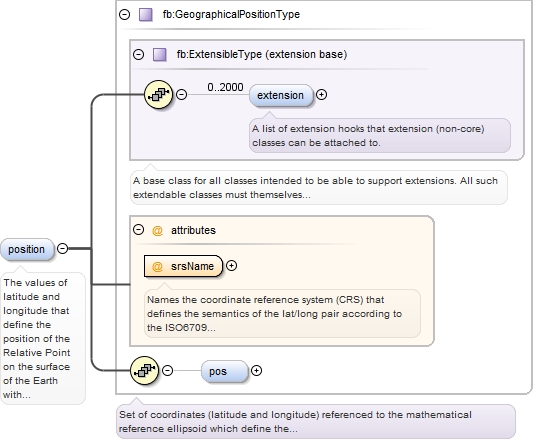
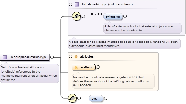
Complex Type fb:GeographicalPositionType
Namespace http://www.fixm.aero/base/4.1
Annotations
Set of coordinates (latitude and longitude) referenced to the mathematical reference 
ellipsoid which define the position of a  point on the surface of the Earth. [ICAO 
Annex 15] 
 
The "srsName" attribute names the coordinate reference system (CRS) that defines 
the semantics of the 
lat/long pair according to the ISO6709 standard. FIXM uses only "urn:ogc:def:crs:EPSG::4326".
Diagram
Diagram Extension_xsd.tmp#ExtensibleType_extension Extension_xsd.tmp#ExtensibleType Airspace_xsd.tmp#GeographicalPositionType_srsName Airspace_xsd.tmp#GeographicalPositionType_pos
Type extension of fb:ExtensibleType
Type hierarchy
Used by
Model fb:extension{0,2000} , fb:pos{0,1}
Children fb:extension, fb:pos
Attributes
QName Type Fixed Default Use Annotation
srsName string urn:ogc:def:crs:EPSG::4326 required
Names the coordinate reference system (CRS) that defines the semantics of the 
lat/long pair according to the ISO6709 standard. FIXM uses only "urn:ogc:def:crs:EPSG::4326".
Source
<complexType name="GeographicalPositionType">
  <annotation>
    <documentation>Set of coordinates (latitude and longitude) referenced to the mathematical reference ellipsoid which define the position of a point on the surface of the Earth. [ICAO Annex 15] The "srsName" attribute names the coordinate reference system (CRS) that defines the semantics of the lat/long pair according to the ISO6709 standard. FIXM uses only "urn:ogc:def:crs:EPSG::4326".</documentation>
  </annotation>
  <complexContent>
    <extension base="fb:ExtensibleType">
      <sequence>
        <element name="pos" minOccurs="0" maxOccurs="1">
          <simpleType>
            <restriction>
              <simpleType>
                <list itemType="double"/>
              </simpleType>
              <length value="2"/>
            </restriction>
          </simpleType>
        </element>
      </sequence>
      <attribute name="srsName" type="xs:string" fixed="urn:ogc:def:crs:EPSG::4326" use="required">
        <annotation>
          <documentation>Names the coordinate reference system (CRS) that defines the semantics of the lat/long pair according to the ISO6709 standard. FIXM uses only "urn:ogc:def:crs:EPSG::4326".</documentation>
        </annotation>
      </attribute>
    </extension>
  </complexContent>
</complexType>
Simple Type fb:SignificantPointDesignatorType
Namespace http://www.fixm.aero/base/4.1
Annotations
A named designator for a significant point (fix).
Diagram
Diagram Types_xsd.tmp#CharacterStringType
Type restriction of fb:CharacterStringType
Type hierarchy
Facets
minLength 0
maxLength 4096
pattern [A-Z0-9]{2,5}
Used by
Source
<simpleType name="SignificantPointDesignatorType">
  <annotation>
    <documentation>A named designator for a significant point (fix).</documentation>
  </annotation>
  <restriction base="fb:CharacterStringType">
    <pattern value="[A-Z0-9]{2,5}"/>
  </restriction>
</simpleType>
Simple Type fb:LongitudeType
Namespace http://www.fixm.aero/base/4.1
Annotations
Longitude value expressed to a decimal precision.
Diagram
Diagram Measures_xsd.tmp#MeasureType
Type restriction of fb:MeasureType
Type hierarchy
Facets
maxInclusive 180
minInclusive -180
Used by
Source
<simpleType name="LongitudeType">
  <annotation>
    <documentation>Longitude value expressed to a decimal precision.</documentation>
  </annotation>
  <restriction base="fb:MeasureType">
    <maxInclusive value="180"/>
    <minInclusive value="-180"/>
  </restriction>
</simpleType>
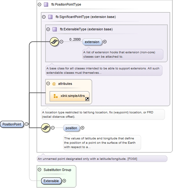
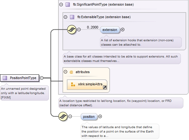
Complex Type fb:PositionPointType
Namespace http://www.fixm.aero/base/4.1
Annotations
An unnamed point designated only with a latitude/longitude. [FIXM]
Diagram
Diagram Extension_xsd.tmp#ExtensibleType_extension Extension_xsd.tmp#ExtensibleType Airspace_xsd.tmp#SignificantPointType Airspace_xsd.tmp#PositionPointType_position
Type extension of fb:SignificantPointType
Type hierarchy
Used by
Model fb:extension{0,2000} , fb:position{0,1}
Children fb:extension, fb:position
Source
<complexType name="PositionPointType">
  <annotation>
    <documentation>An unnamed point designated only with a latitude/longitude. [FIXM]</documentation>
  </annotation>
  <complexContent>
    <extension base="fb:SignificantPointType">
      <sequence>
        <element name="position" type="fb:GeographicalPositionType" minOccurs="0" maxOccurs="1">
          <annotation>
            <documentation>The values of latitude and longitude that define the position of a point on the surface of the Earth with respect to a reference datum. [specialised from ICAO Doc 9881]</documentation>
          </annotation>
        </element>
      </sequence>
    </extension>
  </complexContent>
</complexType>
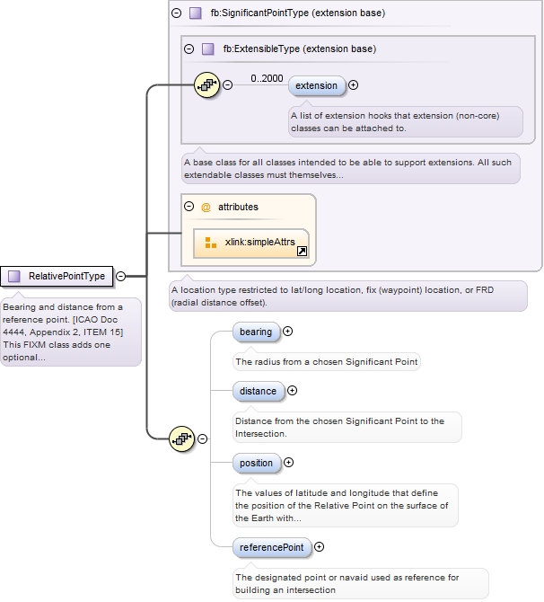
Complex Type fb:RelativePointType
Namespace http://www.fixm.aero/base/4.1
Annotations
Bearing and distance from a reference point. [ICAO Doc 4444, Appendix 2, ITEM 15] 
            
This FIXM class adds one optional property 'position' which may be used as a complement 
to the bearing, distance and reference point information in order to provide the 
computed position of the relative point, if available.
Diagram
Diagram Extension_xsd.tmp#ExtensibleType_extension Extension_xsd.tmp#ExtensibleType Airspace_xsd.tmp#SignificantPointType Airspace_xsd.tmp#RelativePointType_bearing Airspace_xsd.tmp#RelativePointType_distance Airspace_xsd.tmp#RelativePointType_position Airspace_xsd.tmp#RelativePointType_referencePoint
Type extension of fb:SignificantPointType
Type hierarchy
Used by
Model fb:extension{0,2000} , fb:bearing{0,1} , fb:distance{0,1} , fb:position{0,1} , fb:referencePoint{0,1}
Children fb:bearing, fb:distance, fb:extension, fb:position, fb:referencePoint
Source
<complexType name="RelativePointType">
  <annotation>
    <documentation>Bearing and distance from a reference point. [ICAO Doc 4444, Appendix 2, ITEM 15] This FIXM class adds one optional property 'position' which may be used as a complement to the bearing, distance and reference point information in order to provide the computed position of the relative point, if available.</documentation>
  </annotation>
  <complexContent>
    <extension base="fb:SignificantPointType">
      <sequence>
        <element name="bearing" type="fb:BearingType" minOccurs="0" maxOccurs="1">
          <annotation>
            <documentation>The radius from a chosen Significant Point</documentation>
          </annotation>
        </element>
        <element name="distance" type="fb:DistanceType" minOccurs="0" maxOccurs="1">
          <annotation>
            <documentation>Distance from the chosen Significant Point to the Intersection.</documentation>
          </annotation>
        </element>
        <element name="position" type="fb:GeographicalPositionType" minOccurs="0" maxOccurs="1">
          <annotation>
            <documentation>The values of latitude and longitude that define the position of the Relative Point on the surface of the Earth with respect to a reference datum. [specialised from ICAO Doc 9881] This optional field may be used to provide the actual position of the relative point if already known / computed.</documentation>
          </annotation>
        </element>
        <element name="referencePoint" type="fb:DesignatedPointOrNavaidType" minOccurs="0" maxOccurs="1">
          <annotation>
            <documentation>The designated point or navaid used as reference for building an intersection</documentation>
          </annotation>
        </element>
      </sequence>
    </extension>
  </complexContent>
</complexType>
Simple Type fb:RouteDesignatorType
Namespace http://www.fixm.aero/base/4.1
Annotations
The coded designator for a published ATS route or route segment.
Diagram
Diagram Types_xsd.tmp#CharacterStringType
Type restriction of fb:CharacterStringType
Type hierarchy
Facets
minLength 0
maxLength 4096
pattern [A-Z][A-Z0-9]{1,7}
Used by
Source
<simpleType name="RouteDesignatorType">
  <annotation>
    <documentation>The coded designator for a published ATS route or route segment.</documentation>
  </annotation>
  <restriction base="fb:CharacterStringType">
    <pattern value="[A-Z][A-Z0-9]{1,7}"/>
  </restriction>
</simpleType>
Simple Type fb:SidStarAbbreviatedDesignatorType
Namespace http://www.fixm.aero/base/4.1
Annotations
A shortened designator of the SID or STAR. [FIXM] This abbreviated designator is 
based on ARINC 424 chapter 7.4 rules.
Diagram
Diagram Types_xsd.tmp#CharacterStringType
Type restriction of fb:CharacterStringType
Type hierarchy
Facets
minLength 1
maxLength 6
pattern ([A-Z]|[0-9])+([ \+\-/]*([A-Z]|[0-9])+)*
Used by
Source
<simpleType name="SidStarAbbreviatedDesignatorType">
  <annotation>
    <documentation>A shortened designator of the SID or STAR. [FIXM] This abbreviated designator is based on ARINC 424 chapter 7.4 rules.</documentation>
  </annotation>
  <restriction base="fb:CharacterStringType">
    <minLength value="1"/>
    <maxLength value="6"/>
    <pattern value="([A-Z]|[0-9])+([ \+\-/]*([A-Z]|[0-9])+)*"/>
  </restriction>
</simpleType>
Simple Type fb:SidStarDesignatorType
Namespace http://www.fixm.aero/base/4.1
Annotations
The textual designator of a SID or STAR. [Specialised from AIXM 5.1]
Diagram
Diagram Types_xsd.tmp#CharacterStringType
Type restriction of fb:CharacterStringType
Type hierarchy
Facets
minLength 1
maxLength 7
pattern ([A-Z]|[0-9])+([ \+\-/]*([A-Z]|[0-9])+)*
Used by
Source
<simpleType name="SidStarDesignatorType">
  <annotation>
    <documentation>The textual designator of a SID or STAR. [Specialised from AIXM 5.1]</documentation>
  </annotation>
  <restriction base="fb:CharacterStringType">
    <minLength value="1"/>
    <maxLength value="7"/>
    <pattern value="([A-Z]|[0-9])+([ \+\-/]*([A-Z]|[0-9])+)*"/>
  </restriction>
</simpleType>
Attribute fb:GeographicalPositionType / @srsName
Namespace No namespace
Annotations
Names the coordinate reference system (CRS) that defines the semantics of the 
lat/long pair according to the ISO6709 standard. FIXM uses only "urn:ogc:def:crs:EPSG::4326".
Type string
Properties
use: required
fixed: urn:ogc:def:crs:EPSG::4326
Used by
Source
<attribute name="srsName" type="xs:string" fixed="urn:ogc:def:crs:EPSG::4326" use="required">
  <annotation>
    <documentation>Names the coordinate reference system (CRS) that defines the semantics of the lat/long pair according to the ISO6709 standard. FIXM uses only "urn:ogc:def:crs:EPSG::4326".</documentation>
  </annotation>
</attribute>
Attribute fb:DesignatedPointOrNavaidType / @designator
Namespace No namespace
Annotations
A named significant point.
Type fb:SignificantPointDesignatorType
Type hierarchy
Properties
use: optional
Facets
minLength 0
maxLength 4096
pattern [A-Z0-9]{2,5}
Used by
Source
<attribute name="designator" type="fb:SignificantPointDesignatorType" use="optional">
  <annotation>
    <documentation>A named significant point.</documentation>
  </annotation>
</attribute>
Attribute fb:DesignatedPointOrNavaidType / @navaidServiceType
Namespace No namespace
Annotations
Type of the navaid service. [AIXM 5.1] 
This optional field may be used as a complement of the designator in order to achieve 
unambiguous reference to the navaid. 
The combinations of fields that would make the reference unique are: 
- For navaids: designator + position + navaid service type
Type fb:NavaidServiceTypeType
Properties
use: optional
Facets
enumeration DF
Direction Finder.
enumeration DME
Distance Measuring Equipment.
enumeration ILS
Instrument Landing System
enumeration ILS_DME
ILS with collocated DME. Collocation can be with the antenna or the loc.
enumeration LOC
Localizer.
enumeration LOC_DME
LOC and DME collocated.
enumeration MKR
Marker Beacon
enumeration MLS
Microwave Landing System
enumeration MLS_DME
MLS with collocated DME.
enumeration NDB
Non-Directional Radio Beacon
enumeration NDB_DME
NDB and DME collocated.
enumeration NDB_MKR
Non-Directional Radio Beacon and Marker Beacon
enumeration SDF
Simplified Directional Facility.
enumeration TACAN
Tactical Air Navigation Beacon
enumeration TLS
Transponder Landing System
enumeration VOR
VHF Omni directional Radio Range.
enumeration VOR_DME
VOR and DME collocated.
enumeration VORTAC
VOR and TACAN collocated.
Used by
Source
<attribute name="navaidServiceType" type="fb:NavaidServiceTypeType" use="optional">
  <annotation>
    <documentation>Type of the navaid service. [AIXM 5.1] This optional field may be used as a complement of the designator in order to achieve unambiguous reference to the navaid. The combinations of fields that would make the reference unique are: - For navaids: designator + position + navaid service type</documentation>
  </annotation>
</attribute>