| diagram | 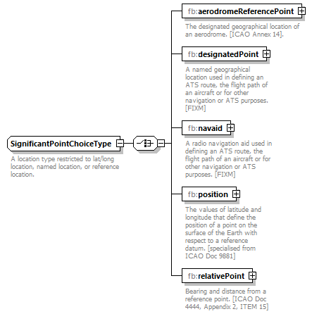 |
||
| namespace | http://www.fixm.aero/base/4.3 | ||
| children | fb:aerodromeReferencePoint fb:designatedPoint fb:navaid fb:position fb:relativePoint | ||
| used by |
|
||
| annotation |
|
||
| source | <xs:complexType name="SignificantPointChoiceType"> <xs:annotation> <xs:documentation>A location type restricted to lat/long location, named location, or reference location.</xs:documentation> </xs:annotation> <xs:choice> <xs:element name="aerodromeReferencePoint" type="fb:AerodromeReferenceType" minOccurs="1" maxOccurs="1"> <xs:annotation> <xs:documentation>The designated geographical location of an aerodrome. [ICAO Annex 14].</xs:documentation> </xs:annotation> </xs:element> <xs:element name="designatedPoint" type="fb:DesignatedPointType" minOccurs="1" maxOccurs="1"> <xs:annotation> <xs:documentation>A named geographical location used in defining an ATS route, the flight path of an aircraft or for other navigation or ATS purposes. [FIXM]</xs:documentation> </xs:annotation> </xs:element> <xs:element name="navaid" type="fb:NavaidType" minOccurs="1" maxOccurs="1"> <xs:annotation> <xs:documentation>A radio navigation aid used in defining an ATS route, the flight path of an aircraft or for other navigation or ATS purposes. [FIXM]</xs:documentation> </xs:annotation> </xs:element> <xs:element name="position" type="fb:GeographicalPositionType" minOccurs="1" maxOccurs="1"> <xs:annotation> <xs:documentation>The values of latitude and longitude that define the position of a point on the surface of the Earth with respect to a reference datum. [specialised from ICAO Doc 9881]</xs:documentation> </xs:annotation> </xs:element> <xs:element name="relativePoint" type="fb:RelativePointType" minOccurs="1" maxOccurs="1"> <xs:annotation> <xs:documentation>Bearing and distance from a reference point. [ICAO Doc 4444, Appendix 2, ITEM 15]</xs:documentation> </xs:annotation> </xs:element> </xs:choice> </xs:complexType> |
element SignificantPointChoiceType/aerodromeReferencePoint
| diagram | 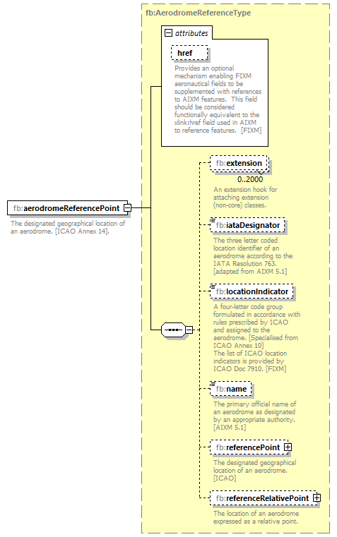 |
||||||||||||||
| namespace | http://www.fixm.aero/base/4.3 | ||||||||||||||
| type | fb:AerodromeReferenceType | ||||||||||||||
| properties |
|
||||||||||||||
| children | fb:extension fb:iataDesignator fb:locationIndicator fb:name fb:referencePoint fb:referenceRelativePoint | ||||||||||||||
| attributes |
|
||||||||||||||
| annotation |
|
||||||||||||||
| source | <xs:element name="aerodromeReferencePoint" type="fb:AerodromeReferenceType" minOccurs="1" maxOccurs="1"> <xs:annotation> <xs:documentation>The designated geographical location of an aerodrome. [ICAO Annex 14].</xs:documentation> </xs:annotation> </xs:element> |
element SignificantPointChoiceType/designatedPoint
| diagram | 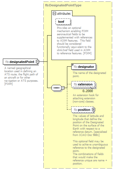 |
||||||||||||||
| namespace | http://www.fixm.aero/base/4.3 | ||||||||||||||
| type | fb:DesignatedPointType | ||||||||||||||
| properties |
|
||||||||||||||
| children | fb:designator fb:extension fb:position | ||||||||||||||
| attributes |
|
||||||||||||||
| annotation |
|
||||||||||||||
| source | <xs:element name="designatedPoint" type="fb:DesignatedPointType" minOccurs="1" maxOccurs="1"> <xs:annotation> <xs:documentation>A named geographical location used in defining an ATS route, the flight path of an aircraft or for other navigation or ATS purposes. [FIXM]</xs:documentation> </xs:annotation> </xs:element> |
element SignificantPointChoiceType/navaid
| diagram | 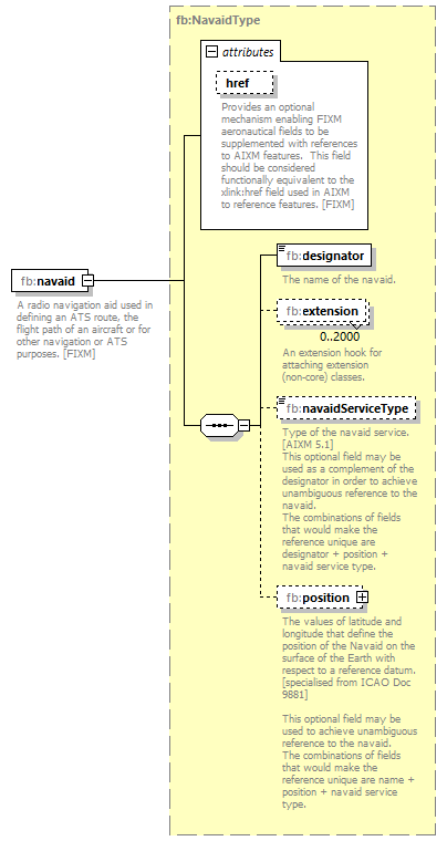 |
||||||||||||||
| namespace | http://www.fixm.aero/base/4.3 | ||||||||||||||
| type | fb:NavaidType | ||||||||||||||
| properties |
|
||||||||||||||
| children | fb:designator fb:extension fb:navaidServiceType fb:position | ||||||||||||||
| attributes |
|
||||||||||||||
| annotation |
|
||||||||||||||
| source | <xs:element name="navaid" type="fb:NavaidType" minOccurs="1" maxOccurs="1"> <xs:annotation> <xs:documentation>A radio navigation aid used in defining an ATS route, the flight path of an aircraft or for other navigation or ATS purposes. [FIXM]</xs:documentation> </xs:annotation> </xs:element> |
element SignificantPointChoiceType/position
| diagram | 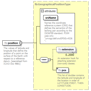 |
||||||||||||||
| namespace | http://www.fixm.aero/base/4.3 | ||||||||||||||
| type | fb:GeographicalPositionType | ||||||||||||||
| properties |
|
||||||||||||||
| children | fb:extension fb:pos | ||||||||||||||
| attributes |
|
||||||||||||||
| annotation |
|
||||||||||||||
| source | <xs:element name="position" type="fb:GeographicalPositionType" minOccurs="1" maxOccurs="1"> <xs:annotation> <xs:documentation>The values of latitude and longitude that define the position of a point on the surface of the Earth with respect to a reference datum. [specialised from ICAO Doc 9881]</xs:documentation> </xs:annotation> </xs:element> |
element SignificantPointChoiceType/relativePoint
| diagram | 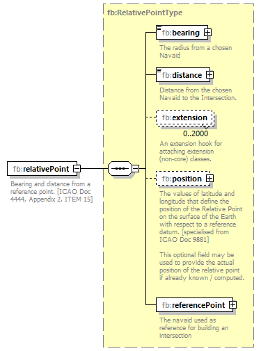 |
||
| namespace | http://www.fixm.aero/base/4.3 | ||
| type | fb:RelativePointType | ||
| properties |
|
||
| children | fb:bearing fb:distance fb:extension fb:position fb:referencePoint | ||
| annotation |
|
||
| source | <xs:element name="relativePoint" type="fb:RelativePointType" minOccurs="1" maxOccurs="1"> <xs:annotation> <xs:documentation>Bearing and distance from a reference point. [ICAO Doc 4444, Appendix 2, ITEM 15]</xs:documentation> </xs:annotation> </xs:element> |
XML Schema documentation generated by XMLSpy Schema Editor http://www.altova.com/xmlspy