Copyright (c) 2014 Airservices Australia, EUROCONTROL, JCAB, NATS Limited, NavCanada, SESAR Joint Undertaking & US FAA =========================================== All rights reserved. Redistribution and use in source and binary forms, with or without modification, are permitted provided that the following conditions are met: * Redistributions of source code must retain the above copyright notice, this list of conditions and the disclaimer. * Redistributions in binary form must reproduce the above copyright notice, this list of conditions and the disclaimer in the documentation and/or other materials provided with the distribution. * Neither the names of Airservices Australia, EUROCONTROL, JCAB, NATS Limited, NavCanada, SESAR Joint Undertaking & US FAA nor the names of their contributors may be used to endorse or promote products derived from this specification without specific prior written permission. DISCLAIMER THIS SPECIFICATION IS PROVIDED BY THE COPYRIGHT HOLDERS AND CONTRIBUTORS "AS IS" AND ANY EXPRESS OR IMPLIED WARRANTIES, INCLUDING, BUT NOT LIMITED TO, THE IMPLIED WARRANTIES OF MERCHANTABILITY AND FITNESS FOR A PARTICULAR PURPOSE ARE DISCLAIMED. IN NO EVENT SHALL THE COPYRIGHT OWNER OR CONTRIBUTORS BE LIABLE FOR ANY DIRECT, INDIRECT, INCIDENTAL, SPECIAL, EXEMPLARY, OR CONSEQUENTIAL DAMAGES (INCLUDING, BUT NOT LIMITED TO, PROCUREMENT OF SUBSTITUTE GOODS OR SERVICES; LOSS OF USE, DATA, OR PROFITS; OR BUSINESS INTERRUPTION) HOWEVER CAUSED AND ON ANY THEORY OF LIABILITY, WHETHER IN CONTRACT, STRICT LIABILITY, OR TORT (INCLUDING NEGLIGENCE OR OTHERWISE) ARISING IN ANY WAY OUT OF THE USE OF THIS SOFTWARE, EVEN IF ADVISED OF THE POSSIBILITY OF SUCH DAMAGE. Editorial note: this license is an instance of the BSD license template as provided by the Open Source Initiative: http://www.opensource.org/licenses/bsd-license.php The authoritative reference for FIXM is www.FIXM.aero. Details on Airservices Australia: http://www.airservicesaustralia.com/ Details on EUROCONTROL: http://www.eurocontrol.int/ Details on JCAB: http://www.mlit.go.jp/en/koku/index.html Details on NATS Limited: http://www.nats.co.uk/ Details on NavCanada: http://www.navcanada.ca/ Details on the SESAR JU and its members: http://www.sesarju.eu/players/members Details on the US FAA: http://www.faa.gov/ Details on the US FAA’s NextGen program: http://www.faa.gov/NextGen
Copyright (c) 2014 Airservices Australia, EUROCONTROL, JCAB, NATS Limited, NavCanada, SESAR Joint Undertaking & US FAA =========================================== All rights reserved. Redistribution and use in source and binary forms, with or without modification, are permitted provided that the following conditions are met: * Redistributions of source code must retain the above copyright notice, this list of conditions and the disclaimer. * Redistributions in binary form must reproduce the above copyright notice, this list of conditions and the disclaimer in the documentation and/or other materials provided with the distribution. * Neither the names of Airservices Australia, EUROCONTROL, JCAB, NATS Limited, NavCanada, SESAR Joint Undertaking & US FAA nor the names of their contributors may be used to endorse or promote products derived from this specification without specific prior written permission. DISCLAIMER THIS SPECIFICATION IS PROVIDED BY THE COPYRIGHT HOLDERS AND CONTRIBUTORS "AS IS" AND ANY EXPRESS OR IMPLIED WARRANTIES, INCLUDING, BUT NOT LIMITED TO, THE IMPLIED WARRANTIES OF MERCHANTABILITY AND FITNESS FOR A PARTICULAR PURPOSE ARE DISCLAIMED. IN NO EVENT SHALL THE COPYRIGHT OWNER OR CONTRIBUTORS BE LIABLE FOR ANY DIRECT, INDIRECT, INCIDENTAL, SPECIAL, EXEMPLARY, OR CONSEQUENTIAL DAMAGES (INCLUDING, BUT NOT LIMITED TO, PROCUREMENT OF SUBSTITUTE GOODS OR SERVICES; LOSS OF USE, DATA, OR PROFITS; OR BUSINESS INTERRUPTION) HOWEVER CAUSED AND ON ANY THEORY OF LIABILITY, WHETHER IN CONTRACT, STRICT LIABILITY, OR TORT (INCLUDING NEGLIGENCE OR OTHERWISE) ARISING IN ANY WAY OUT OF THE USE OF THIS SOFTWARE, EVEN IF ADVISED OF THE POSSIBILITY OF SUCH DAMAGE. Editorial note: this license is an instance of the BSD license template as provided by the Open Source Initiative: http://www.opensource.org/licenses/bsd-license.php The authoritative reference for FIXM is www.FIXM.aero. Details on Airservices Australia: http://www.airservicesaustralia.com/ Details on EUROCONTROL: http://www.eurocontrol.int/ Details on JCAB: http://www.mlit.go.jp/en/koku/index.html Details on NATS Limited: http://www.nats.co.uk/ Details on NavCanada: http://www.navcanada.ca/ Details on the SESAR JU and its members: http://www.sesarju.eu/players/members Details on the US FAA: http://www.faa.gov/ Details on the US FAA’s NextGen program: http://www.faa.gov/NextGen
The base schemas contain the most basic of the FIXM data structures, and should be used by all schemas that need to represent these objects.
Copyright (c) 2014 Airservices Australia, EUROCONTROL, JCAB, NATS Limited, NavCanada, SESAR Joint Undertaking & US FAA =========================================== All rights reserved. Redistribution and use in source and binary forms, with or without modification, are permitted provided that the following conditions are met: * Redistributions of source code must retain the above copyright notice, this list of conditions and the disclaimer. * Redistributions in binary form must reproduce the above copyright notice, this list of conditions and the disclaimer in the documentation and/or other materials provided with the distribution. * Neither the names of Airservices Australia, EUROCONTROL, JCAB, NATS Limited, NavCanada, SESAR Joint Undertaking & US FAA nor the names of their contributors may be used to endorse or promote products derived from this specification without specific prior written permission. DISCLAIMER THIS SPECIFICATION IS PROVIDED BY THE COPYRIGHT HOLDERS AND CONTRIBUTORS "AS IS" AND ANY EXPRESS OR IMPLIED WARRANTIES, INCLUDING, BUT NOT LIMITED TO, THE IMPLIED WARRANTIES OF MERCHANTABILITY AND FITNESS FOR A PARTICULAR PURPOSE ARE DISCLAIMED. IN NO EVENT SHALL THE COPYRIGHT OWNER OR CONTRIBUTORS BE LIABLE FOR ANY DIRECT, INDIRECT, INCIDENTAL, SPECIAL, EXEMPLARY, OR CONSEQUENTIAL DAMAGES (INCLUDING, BUT NOT LIMITED TO, PROCUREMENT OF SUBSTITUTE GOODS OR SERVICES; LOSS OF USE, DATA, OR PROFITS; OR BUSINESS INTERRUPTION) HOWEVER CAUSED AND ON ANY THEORY OF LIABILITY, WHETHER IN CONTRACT, STRICT LIABILITY, OR TORT (INCLUDING NEGLIGENCE OR OTHERWISE) ARISING IN ANY WAY OUT OF THE USE OF THIS SOFTWARE, EVEN IF ADVISED OF THE POSSIBILITY OF SUCH DAMAGE. Editorial note: this license is an instance of the BSD license template as provided by the Open Source Initiative: http://www.opensource.org/licenses/bsd-license.php The authoritative reference for FIXM is www.FIXM.aero. Details on Airservices Australia: http://www.airservicesaustralia.com/ Details on EUROCONTROL: http://www.eurocontrol.int/ Details on JCAB: http://www.mlit.go.jp/en/koku/index.html Details on NATS Limited: http://www.nats.co.uk/ Details on NavCanada: http://www.navcanada.ca/ Details on the SESAR JU and its members: http://www.sesarju.eu/players/members Details on the US FAA: http://www.faa.gov/ Details on the US FAA’s NextGen program: http://www.faa.gov/NextGen
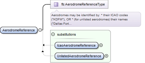
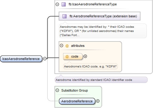
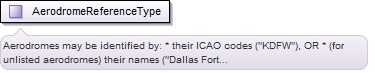
The Base.Aerodrome schema contains information about aerodromes needed by flight data.
Copyright (c) 2014 Airservices Australia, EUROCONTROL, JCAB, NATS Limited, NavCanada, SESAR Joint Undertaking & US FAA =========================================== All rights reserved. Redistribution and use in source and binary forms, with or without modification, are permitted provided that the following conditions are met: * Redistributions of source code must retain the above copyright notice, this list of conditions and the disclaimer. * Redistributions in binary form must reproduce the above copyright notice, this list of conditions and the disclaimer in the documentation and/or other materials provided with the distribution. * Neither the names of Airservices Australia, EUROCONTROL, JCAB, NATS Limited, NavCanada, SESAR Joint Undertaking & US FAA nor the names of their contributors may be used to endorse or promote products derived from this specification without specific prior written permission. DISCLAIMER THIS SPECIFICATION IS PROVIDED BY THE COPYRIGHT HOLDERS AND CONTRIBUTORS "AS IS" AND ANY EXPRESS OR IMPLIED WARRANTIES, INCLUDING, BUT NOT LIMITED TO, THE IMPLIED WARRANTIES OF MERCHANTABILITY AND FITNESS FOR A PARTICULAR PURPOSE ARE DISCLAIMED. IN NO EVENT SHALL THE COPYRIGHT OWNER OR CONTRIBUTORS BE LIABLE FOR ANY DIRECT, INDIRECT, INCIDENTAL, SPECIAL, EXEMPLARY, OR CONSEQUENTIAL DAMAGES (INCLUDING, BUT NOT LIMITED TO, PROCUREMENT OF SUBSTITUTE GOODS OR SERVICES; LOSS OF USE, DATA, OR PROFITS; OR BUSINESS INTERRUPTION) HOWEVER CAUSED AND ON ANY THEORY OF LIABILITY, WHETHER IN CONTRACT, STRICT LIABILITY, OR TORT (INCLUDING NEGLIGENCE OR OTHERWISE) ARISING IN ANY WAY OUT OF THE USE OF THIS SOFTWARE, EVEN IF ADVISED OF THE POSSIBILITY OF SUCH DAMAGE. Editorial note: this license is an instance of the BSD license template as provided by the Open Source Initiative: http://www.opensource.org/licenses/bsd-license.php The authoritative reference for FIXM is www.FIXM.aero. Details on Airservices Australia: http://www.airservicesaustralia.com/ Details on EUROCONTROL: http://www.eurocontrol.int/ Details on JCAB: http://www.mlit.go.jp/en/koku/index.html Details on NATS Limited: http://www.nats.co.uk/ Details on NavCanada: http://www.navcanada.ca/ Details on the SESAR JU and its members: http://www.sesarju.eu/players/members Details on the US FAA: http://www.faa.gov/ Details on the US FAA’s NextGen program: http://www.faa.gov/NextGen
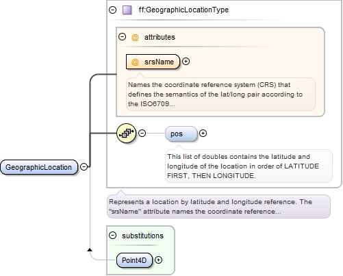
The Base.Location schema provides representations for a geographic location.
Copyright (c) 2014 Airservices Australia, EUROCONTROL, JCAB, NATS Limited, NavCanada, SESAR Joint Undertaking & US FAA =========================================== All rights reserved. Redistribution and use in source and binary forms, with or without modification, are permitted provided that the following conditions are met: * Redistributions of source code must retain the above copyright notice, this list of conditions and the disclaimer. * Redistributions in binary form must reproduce the above copyright notice, this list of conditions and the disclaimer in the documentation and/or other materials provided with the distribution. * Neither the names of Airservices Australia, EUROCONTROL, JCAB, NATS Limited, NavCanada, SESAR Joint Undertaking & US FAA nor the names of their contributors may be used to endorse or promote products derived from this specification without specific prior written permission. DISCLAIMER THIS SPECIFICATION IS PROVIDED BY THE COPYRIGHT HOLDERS AND CONTRIBUTORS "AS IS" AND ANY EXPRESS OR IMPLIED WARRANTIES, INCLUDING, BUT NOT LIMITED TO, THE IMPLIED WARRANTIES OF MERCHANTABILITY AND FITNESS FOR A PARTICULAR PURPOSE ARE DISCLAIMED. IN NO EVENT SHALL THE COPYRIGHT OWNER OR CONTRIBUTORS BE LIABLE FOR ANY DIRECT, INDIRECT, INCIDENTAL, SPECIAL, EXEMPLARY, OR CONSEQUENTIAL DAMAGES (INCLUDING, BUT NOT LIMITED TO, PROCUREMENT OF SUBSTITUTE GOODS OR SERVICES; LOSS OF USE, DATA, OR PROFITS; OR BUSINESS INTERRUPTION) HOWEVER CAUSED AND ON ANY THEORY OF LIABILITY, WHETHER IN CONTRACT, STRICT LIABILITY, OR TORT (INCLUDING NEGLIGENCE OR OTHERWISE) ARISING IN ANY WAY OUT OF THE USE OF THIS SOFTWARE, EVEN IF ADVISED OF THE POSSIBILITY OF SUCH DAMAGE. Editorial note: this license is an instance of the BSD license template as provided by the Open Source Initiative: http://www.opensource.org/licenses/bsd-license.php The authoritative reference for FIXM is www.FIXM.aero. Details on Airservices Australia: http://www.airservicesaustralia.com/ Details on EUROCONTROL: http://www.eurocontrol.int/ Details on JCAB: http://www.mlit.go.jp/en/koku/index.html Details on NATS Limited: http://www.nats.co.uk/ Details on NavCanada: http://www.navcanada.ca/ Details on the SESAR JU and its members: http://www.sesarju.eu/players/members Details on the US FAA: http://www.faa.gov/ Details on the US FAA’s NextGen program: http://www.faa.gov/NextGen
The base schemas contain the most basic of the FIXM data structures, and should be used by all schemas that need to represent these objects.
Copyright (c) 2014 Airservices Australia, EUROCONTROL, JCAB, NATS Limited, NavCanada, SESAR Joint Undertaking & US FAA =========================================== All rights reserved. Redistribution and use in source and binary forms, with or without modification, are permitted provided that the following conditions are met: * Redistributions of source code must retain the above copyright notice, this list of conditions and the disclaimer. * Redistributions in binary form must reproduce the above copyright notice, this list of conditions and the disclaimer in the documentation and/or other materials provided with the distribution. * Neither the names of Airservices Australia, EUROCONTROL, JCAB, NATS Limited, NavCanada, SESAR Joint Undertaking & US FAA nor the names of their contributors may be used to endorse or promote products derived from this specification without specific prior written permission. DISCLAIMER THIS SPECIFICATION IS PROVIDED BY THE COPYRIGHT HOLDERS AND CONTRIBUTORS "AS IS" AND ANY EXPRESS OR IMPLIED WARRANTIES, INCLUDING, BUT NOT LIMITED TO, THE IMPLIED WARRANTIES OF MERCHANTABILITY AND FITNESS FOR A PARTICULAR PURPOSE ARE DISCLAIMED. IN NO EVENT SHALL THE COPYRIGHT OWNER OR CONTRIBUTORS BE LIABLE FOR ANY DIRECT, INDIRECT, INCIDENTAL, SPECIAL, EXEMPLARY, OR CONSEQUENTIAL DAMAGES (INCLUDING, BUT NOT LIMITED TO, PROCUREMENT OF SUBSTITUTE GOODS OR SERVICES; LOSS OF USE, DATA, OR PROFITS; OR BUSINESS INTERRUPTION) HOWEVER CAUSED AND ON ANY THEORY OF LIABILITY, WHETHER IN CONTRACT, STRICT LIABILITY, OR TORT (INCLUDING NEGLIGENCE OR OTHERWISE) ARISING IN ANY WAY OUT OF THE USE OF THIS SOFTWARE, EVEN IF ADVISED OF THE POSSIBILITY OF SUCH DAMAGE. Editorial note: this license is an instance of the BSD license template as provided by the Open Source Initiative: http://www.opensource.org/licenses/bsd-license.php The authoritative reference for FIXM is www.FIXM.aero. Details on Airservices Australia: http://www.airservicesaustralia.com/ Details on EUROCONTROL: http://www.eurocontrol.int/ Details on JCAB: http://www.mlit.go.jp/en/koku/index.html Details on NATS Limited: http://www.nats.co.uk/ Details on NavCanada: http://www.navcanada.ca/ Details on the SESAR JU and its members: http://www.sesarju.eu/players/members Details on the US FAA: http://www.faa.gov/ Details on the US FAA’s NextGen program: http://www.faa.gov/NextGen
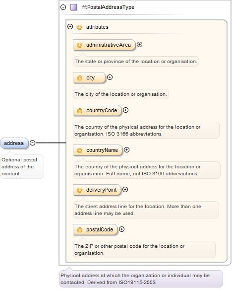
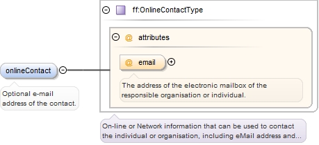
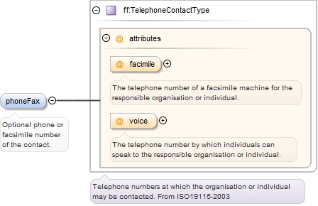
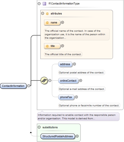
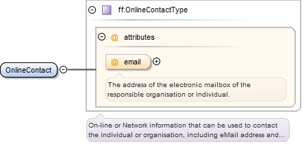
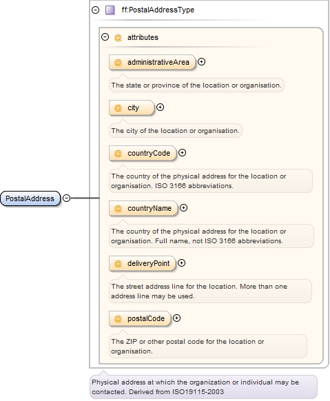
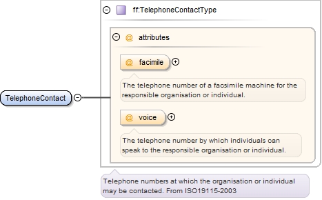
The Address schema contains all FIXM definitions for addresses and other contact information.
Copyright (c) 2014 Airservices Australia, EUROCONTROL, JCAB, NATS Limited, NavCanada, SESAR Joint Undertaking & US FAA =========================================== All rights reserved. Redistribution and use in source and binary forms, with or without modification, are permitted provided that the following conditions are met: * Redistributions of source code must retain the above copyright notice, this list of conditions and the disclaimer. * Redistributions in binary form must reproduce the above copyright notice, this list of conditions and the disclaimer in the documentation and/or other materials provided with the distribution. * Neither the names of Airservices Australia, EUROCONTROL, JCAB, NATS Limited, NavCanada, SESAR Joint Undertaking & US FAA nor the names of their contributors may be used to endorse or promote products derived from this specification without specific prior written permission. DISCLAIMER THIS SPECIFICATION IS PROVIDED BY THE COPYRIGHT HOLDERS AND CONTRIBUTORS "AS IS" AND ANY EXPRESS OR IMPLIED WARRANTIES, INCLUDING, BUT NOT LIMITED TO, THE IMPLIED WARRANTIES OF MERCHANTABILITY AND FITNESS FOR A PARTICULAR PURPOSE ARE DISCLAIMED. IN NO EVENT SHALL THE COPYRIGHT OWNER OR CONTRIBUTORS BE LIABLE FOR ANY DIRECT, INDIRECT, INCIDENTAL, SPECIAL, EXEMPLARY, OR CONSEQUENTIAL DAMAGES (INCLUDING, BUT NOT LIMITED TO, PROCUREMENT OF SUBSTITUTE GOODS OR SERVICES; LOSS OF USE, DATA, OR PROFITS; OR BUSINESS INTERRUPTION) HOWEVER CAUSED AND ON ANY THEORY OF LIABILITY, WHETHER IN CONTRACT, STRICT LIABILITY, OR TORT (INCLUDING NEGLIGENCE OR OTHERWISE) ARISING IN ANY WAY OUT OF THE USE OF THIS SOFTWARE, EVEN IF ADVISED OF THE POSSIBILITY OF SUCH DAMAGE. Editorial note: this license is an instance of the BSD license template as provided by the Open Source Initiative: http://www.opensource.org/licenses/bsd-license.php The authoritative reference for FIXM is www.FIXM.aero. Details on Airservices Australia: http://www.airservicesaustralia.com/ Details on EUROCONTROL: http://www.eurocontrol.int/ Details on JCAB: http://www.mlit.go.jp/en/koku/index.html Details on NATS Limited: http://www.nats.co.uk/ Details on NavCanada: http://www.navcanada.ca/ Details on the SESAR JU and its members: http://www.sesarju.eu/players/members Details on the US FAA: http://www.faa.gov/ Details on the US FAA’s NextGen program: http://www.faa.gov/NextGen
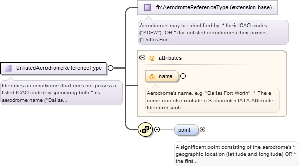
Contains information about aerodromes needed by flight data.
Copyright (c) 2014 Airservices Australia, EUROCONTROL, JCAB, NATS Limited, NavCanada, SESAR Joint Undertaking & US FAA =========================================== All rights reserved. Redistribution and use in source and binary forms, with or without modification, are permitted provided that the following conditions are met: * Redistributions of source code must retain the above copyright notice, this list of conditions and the disclaimer. * Redistributions in binary form must reproduce the above copyright notice, this list of conditions and the disclaimer in the documentation and/or other materials provided with the distribution. * Neither the names of Airservices Australia, EUROCONTROL, JCAB, NATS Limited, NavCanada, SESAR Joint Undertaking & US FAA nor the names of their contributors may be used to endorse or promote products derived from this specification without specific prior written permission. DISCLAIMER THIS SPECIFICATION IS PROVIDED BY THE COPYRIGHT HOLDERS AND CONTRIBUTORS "AS IS" AND ANY EXPRESS OR IMPLIED WARRANTIES, INCLUDING, BUT NOT LIMITED TO, THE IMPLIED WARRANTIES OF MERCHANTABILITY AND FITNESS FOR A PARTICULAR PURPOSE ARE DISCLAIMED. IN NO EVENT SHALL THE COPYRIGHT OWNER OR CONTRIBUTORS BE LIABLE FOR ANY DIRECT, INDIRECT, INCIDENTAL, SPECIAL, EXEMPLARY, OR CONSEQUENTIAL DAMAGES (INCLUDING, BUT NOT LIMITED TO, PROCUREMENT OF SUBSTITUTE GOODS OR SERVICES; LOSS OF USE, DATA, OR PROFITS; OR BUSINESS INTERRUPTION) HOWEVER CAUSED AND ON ANY THEORY OF LIABILITY, WHETHER IN CONTRACT, STRICT LIABILITY, OR TORT (INCLUDING NEGLIGENCE OR OTHERWISE) ARISING IN ANY WAY OUT OF THE USE OF THIS SOFTWARE, EVEN IF ADVISED OF THE POSSIBILITY OF SUCH DAMAGE. Editorial note: this license is an instance of the BSD license template as provided by the Open Source Initiative: http://www.opensource.org/licenses/bsd-license.php The authoritative reference for FIXM is www.FIXM.aero. Details on Airservices Australia: http://www.airservicesaustralia.com/ Details on EUROCONTROL: http://www.eurocontrol.int/ Details on JCAB: http://www.mlit.go.jp/en/koku/index.html Details on NATS Limited: http://www.nats.co.uk/ Details on NavCanada: http://www.navcanada.ca/ Details on the SESAR JU and its members: http://www.sesarju.eu/players/members Details on the US FAA: http://www.faa.gov/ Details on the US FAA’s NextGen program: http://www.faa.gov/NextGen
The Airspace schema contains FIXM definitions for airspace-related entities.
Copyright (c) 2014 Airservices Australia, EUROCONTROL, JCAB, NATS Limited, NavCanada, SESAR Joint Undertaking & US FAA =========================================== All rights reserved. Redistribution and use in source and binary forms, with or without modification, are permitted provided that the following conditions are met: * Redistributions of source code must retain the above copyright notice, this list of conditions and the disclaimer. * Redistributions in binary form must reproduce the above copyright notice, this list of conditions and the disclaimer in the documentation and/or other materials provided with the distribution. * Neither the names of Airservices Australia, EUROCONTROL, JCAB, NATS Limited, NavCanada, SESAR Joint Undertaking & US FAA nor the names of their contributors may be used to endorse or promote products derived from this specification without specific prior written permission. DISCLAIMER THIS SPECIFICATION IS PROVIDED BY THE COPYRIGHT HOLDERS AND CONTRIBUTORS "AS IS" AND ANY EXPRESS OR IMPLIED WARRANTIES, INCLUDING, BUT NOT LIMITED TO, THE IMPLIED WARRANTIES OF MERCHANTABILITY AND FITNESS FOR A PARTICULAR PURPOSE ARE DISCLAIMED. IN NO EVENT SHALL THE COPYRIGHT OWNER OR CONTRIBUTORS BE LIABLE FOR ANY DIRECT, INDIRECT, INCIDENTAL, SPECIAL, EXEMPLARY, OR CONSEQUENTIAL DAMAGES (INCLUDING, BUT NOT LIMITED TO, PROCUREMENT OF SUBSTITUTE GOODS OR SERVICES; LOSS OF USE, DATA, OR PROFITS; OR BUSINESS INTERRUPTION) HOWEVER CAUSED AND ON ANY THEORY OF LIABILITY, WHETHER IN CONTRACT, STRICT LIABILITY, OR TORT (INCLUDING NEGLIGENCE OR OTHERWISE) ARISING IN ANY WAY OUT OF THE USE OF THIS SOFTWARE, EVEN IF ADVISED OF THE POSSIBILITY OF SUCH DAMAGE. Editorial note: this license is an instance of the BSD license template as provided by the Open Source Initiative: http://www.opensource.org/licenses/bsd-license.php The authoritative reference for FIXM is www.FIXM.aero. Details on Airservices Australia: http://www.airservicesaustralia.com/ Details on EUROCONTROL: http://www.eurocontrol.int/ Details on JCAB: http://www.mlit.go.jp/en/koku/index.html Details on NATS Limited: http://www.nats.co.uk/ Details on NavCanada: http://www.navcanada.ca/ Details on the SESAR JU and its members: http://www.sesarju.eu/players/members Details on the US FAA: http://www.faa.gov/ Details on the US FAA’s NextGen program: http://www.faa.gov/NextGen
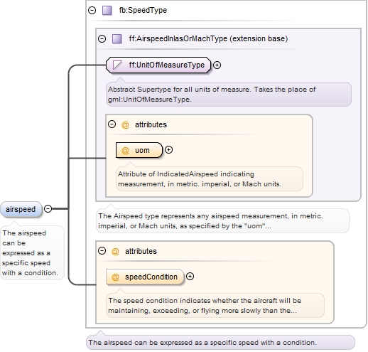
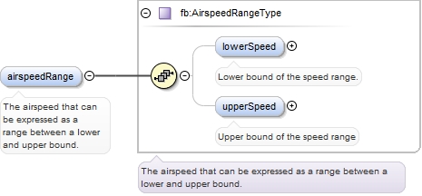
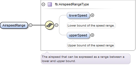
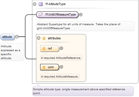
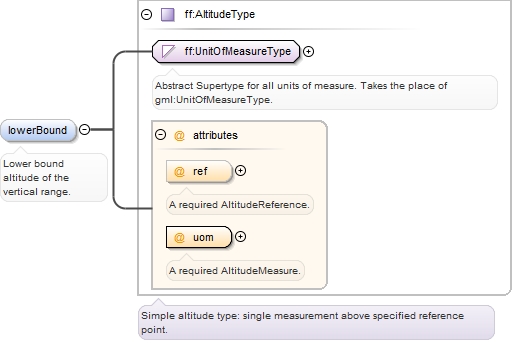
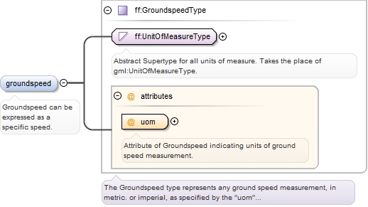
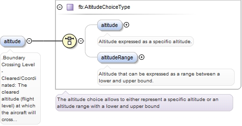
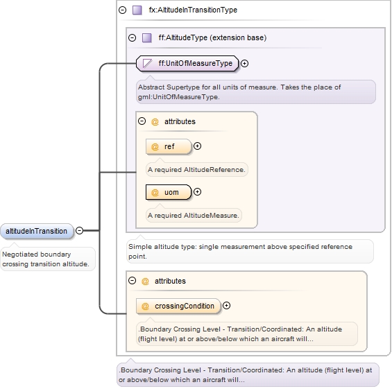
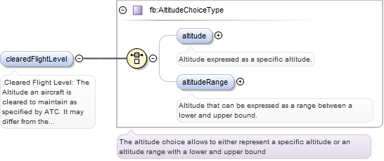
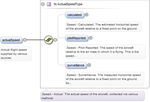
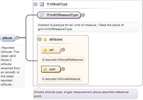
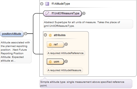
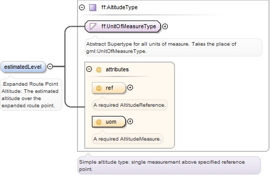
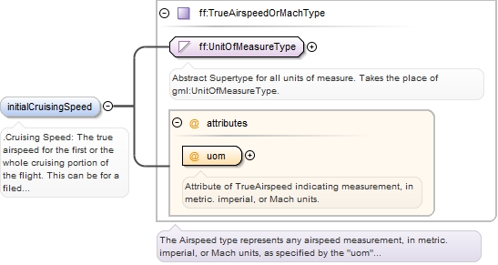
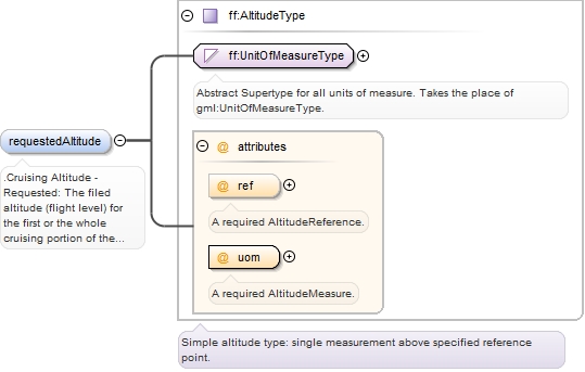
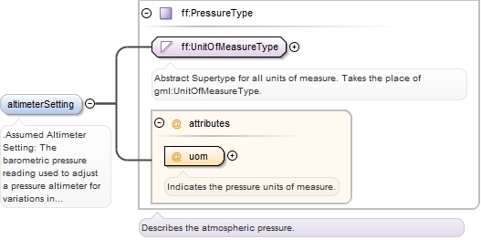
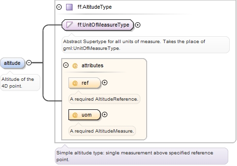
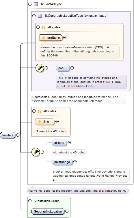
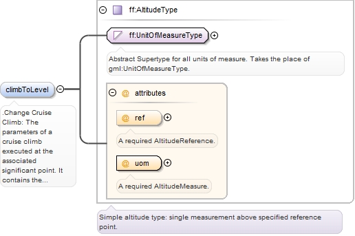
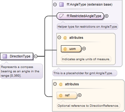
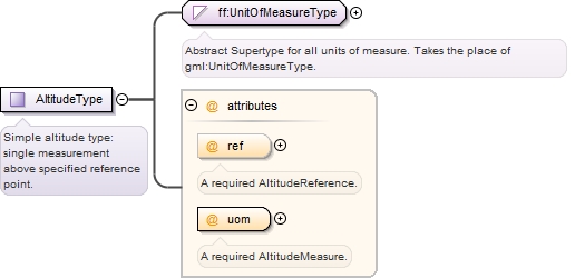
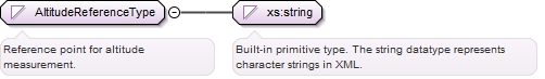
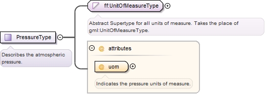
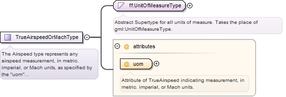
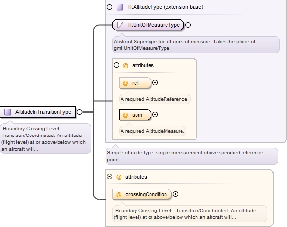
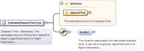
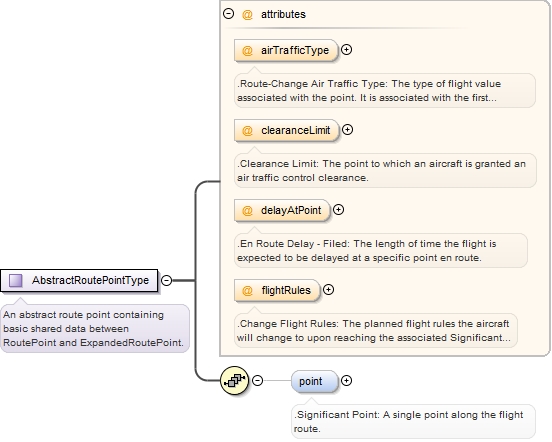
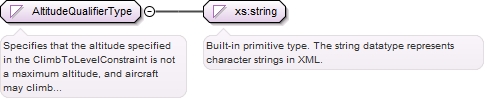
Altitudes may be recorded in units of feet (FT) or meters (M), this attribute is required, with no default unit. Altitudes always record the actual number of feet/meters, even when the conventional notation is expressed in multiples of tens or hundreds. Altitudes are always referenced to the concept of mean sea level. Depending on the aircraft’s altimeter pressure setting, the reference is to Flight Level (FL), (when set to standard pressure), or the reference is to Mean Sea Level (MSL), (when set to local pressure).
Copyright (c) 2014 Airservices Australia, EUROCONTROL, JCAB, NATS Limited, NavCanada, SESAR Joint Undertaking & US FAA =========================================== All rights reserved. Redistribution and use in source and binary forms, with or without modification, are permitted provided that the following conditions are met: * Redistributions of source code must retain the above copyright notice, this list of conditions and the disclaimer. * Redistributions in binary form must reproduce the above copyright notice, this list of conditions and the disclaimer in the documentation and/or other materials provided with the distribution. * Neither the names of Airservices Australia, EUROCONTROL, JCAB, NATS Limited, NavCanada, SESAR Joint Undertaking & US FAA nor the names of their contributors may be used to endorse or promote products derived from this specification without specific prior written permission. DISCLAIMER THIS SPECIFICATION IS PROVIDED BY THE COPYRIGHT HOLDERS AND CONTRIBUTORS "AS IS" AND ANY EXPRESS OR IMPLIED WARRANTIES, INCLUDING, BUT NOT LIMITED TO, THE IMPLIED WARRANTIES OF MERCHANTABILITY AND FITNESS FOR A PARTICULAR PURPOSE ARE DISCLAIMED. IN NO EVENT SHALL THE COPYRIGHT OWNER OR CONTRIBUTORS BE LIABLE FOR ANY DIRECT, INDIRECT, INCIDENTAL, SPECIAL, EXEMPLARY, OR CONSEQUENTIAL DAMAGES (INCLUDING, BUT NOT LIMITED TO, PROCUREMENT OF SUBSTITUTE GOODS OR SERVICES; LOSS OF USE, DATA, OR PROFITS; OR BUSINESS INTERRUPTION) HOWEVER CAUSED AND ON ANY THEORY OF LIABILITY, WHETHER IN CONTRACT, STRICT LIABILITY, OR TORT (INCLUDING NEGLIGENCE OR OTHERWISE) ARISING IN ANY WAY OUT OF THE USE OF THIS SOFTWARE, EVEN IF ADVISED OF THE POSSIBILITY OF SUCH DAMAGE. Editorial note: this license is an instance of the BSD license template as provided by the Open Source Initiative: http://www.opensource.org/licenses/bsd-license.php The authoritative reference for FIXM is www.FIXM.aero. Details on Airservices Australia: http://www.airservicesaustralia.com/ Details on EUROCONTROL: http://www.eurocontrol.int/ Details on JCAB: http://www.mlit.go.jp/en/koku/index.html Details on NATS Limited: http://www.nats.co.uk/ Details on NavCanada: http://www.navcanada.ca/ Details on the SESAR JU and its members: http://www.sesarju.eu/players/members Details on the US FAA: http://www.faa.gov/ Details on the US FAA’s NextGen program: http://www.faa.gov/NextGen
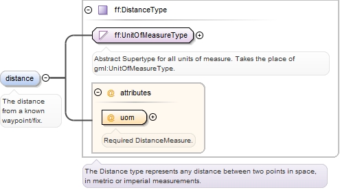
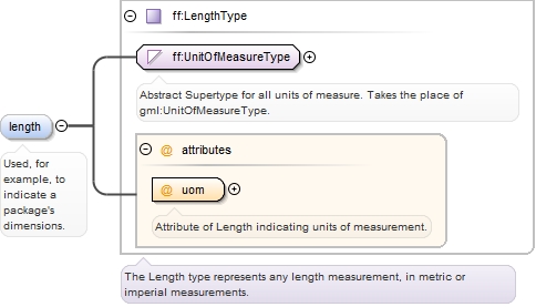
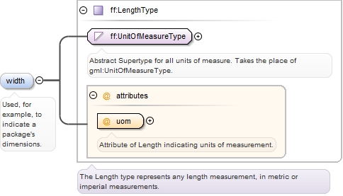
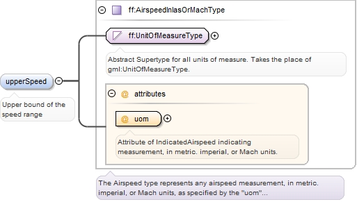
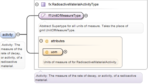
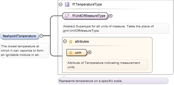
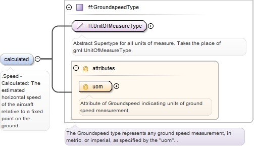
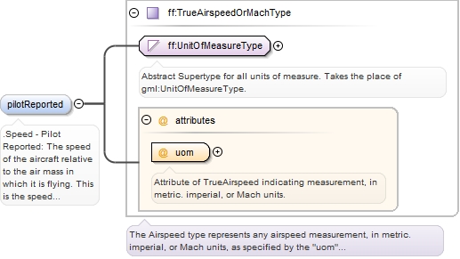
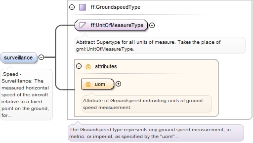
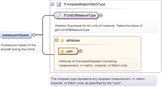
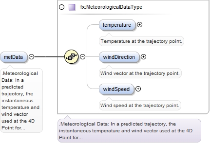
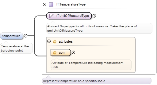
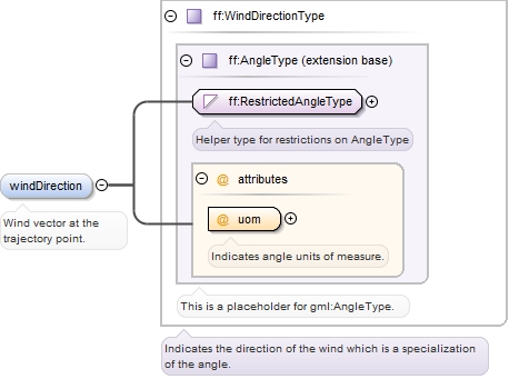
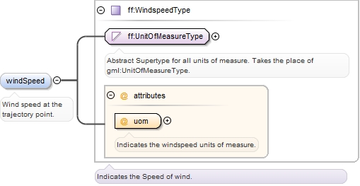
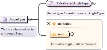
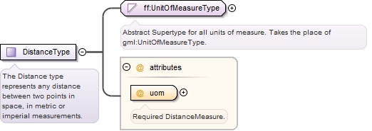
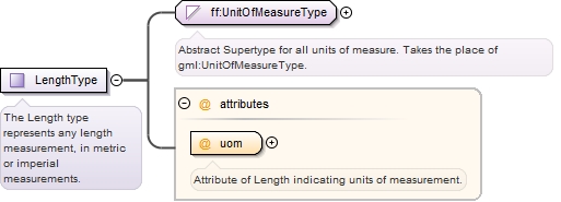
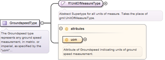
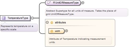
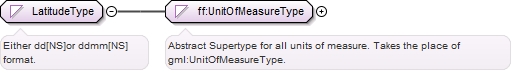
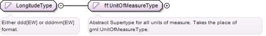
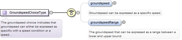
The types schema defines the representation of several physical quantities and measurements and utility types like counts and free text. Every quantity type carries a "uom" attribute that describes the units of measurements as an appropriate enumeration.
Copyright (c) 2014 Airservices Australia, EUROCONTROL, JCAB, NATS Limited, NavCanada, SESAR Joint Undertaking & US FAA =========================================== All rights reserved. Redistribution and use in source and binary forms, with or without modification, are permitted provided that the following conditions are met: * Redistributions of source code must retain the above copyright notice, this list of conditions and the disclaimer. * Redistributions in binary form must reproduce the above copyright notice, this list of conditions and the disclaimer in the documentation and/or other materials provided with the distribution. * Neither the names of Airservices Australia, EUROCONTROL, JCAB, NATS Limited, NavCanada, SESAR Joint Undertaking & US FAA nor the names of their contributors may be used to endorse or promote products derived from this specification without specific prior written permission. DISCLAIMER THIS SPECIFICATION IS PROVIDED BY THE COPYRIGHT HOLDERS AND CONTRIBUTORS "AS IS" AND ANY EXPRESS OR IMPLIED WARRANTIES, INCLUDING, BUT NOT LIMITED TO, THE IMPLIED WARRANTIES OF MERCHANTABILITY AND FITNESS FOR A PARTICULAR PURPOSE ARE DISCLAIMED. IN NO EVENT SHALL THE COPYRIGHT OWNER OR CONTRIBUTORS BE LIABLE FOR ANY DIRECT, INDIRECT, INCIDENTAL, SPECIAL, EXEMPLARY, OR CONSEQUENTIAL DAMAGES (INCLUDING, BUT NOT LIMITED TO, PROCUREMENT OF SUBSTITUTE GOODS OR SERVICES; LOSS OF USE, DATA, OR PROFITS; OR BUSINESS INTERRUPTION) HOWEVER CAUSED AND ON ANY THEORY OF LIABILITY, WHETHER IN CONTRACT, STRICT LIABILITY, OR TORT (INCLUDING NEGLIGENCE OR OTHERWISE) ARISING IN ANY WAY OUT OF THE USE OF THIS SOFTWARE, EVEN IF ADVISED OF THE POSSIBILITY OF SUCH DAMAGE. Editorial note: this license is an instance of the BSD license template as provided by the Open Source Initiative: http://www.opensource.org/licenses/bsd-license.php The authoritative reference for FIXM is www.FIXM.aero. Details on Airservices Australia: http://www.airservicesaustralia.com/ Details on EUROCONTROL: http://www.eurocontrol.int/ Details on JCAB: http://www.mlit.go.jp/en/koku/index.html Details on NATS Limited: http://www.nats.co.uk/ Details on NavCanada: http://www.navcanada.ca/ Details on the SESAR JU and its members: http://www.sesarju.eu/players/members Details on the US FAA: http://www.faa.gov/ Details on the US FAA’s NextGen program: http://www.faa.gov/NextGen
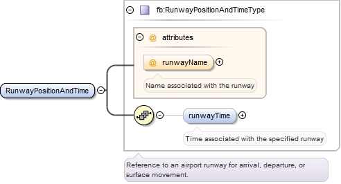
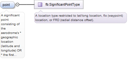
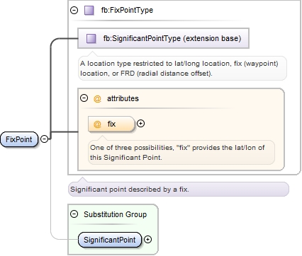
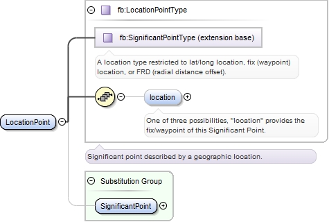
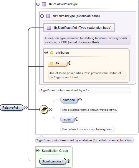
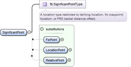
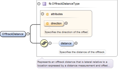
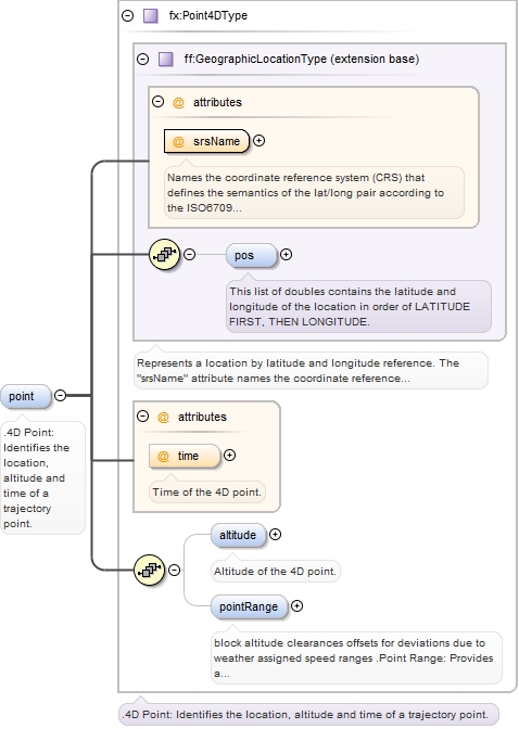
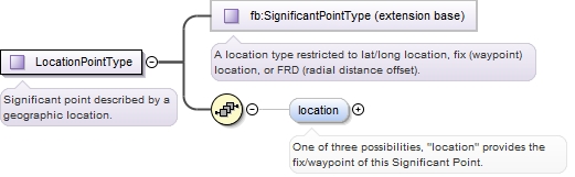
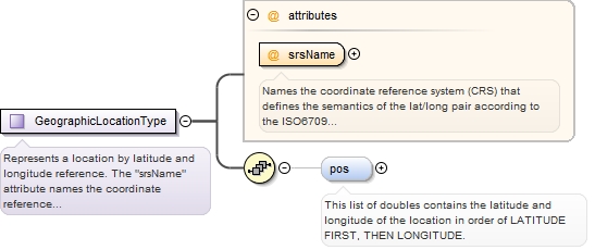
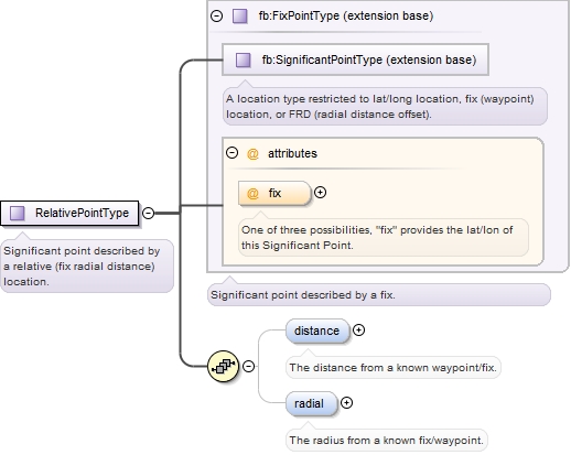
The location schema contains all FIXM definitions for locations. "Locations" can be more complex than simple geographic points: they also encompass waypoints (fixes, etc) and offsets from other points: anything that can be mapped to a geographic location. Furthermore, extensions may add new location types as needed.
Copyright (c) 2014 Airservices Australia, EUROCONTROL, JCAB, NATS Limited, NavCanada, SESAR Joint Undertaking & US FAA =========================================== All rights reserved. Redistribution and use in source and binary forms, with or without modification, are permitted provided that the following conditions are met: * Redistributions of source code must retain the above copyright notice, this list of conditions and the disclaimer. * Redistributions in binary form must reproduce the above copyright notice, this list of conditions and the disclaimer in the documentation and/or other materials provided with the distribution. * Neither the names of Airservices Australia, EUROCONTROL, JCAB, NATS Limited, NavCanada, SESAR Joint Undertaking & US FAA nor the names of their contributors may be used to endorse or promote products derived from this specification without specific prior written permission. DISCLAIMER THIS SPECIFICATION IS PROVIDED BY THE COPYRIGHT HOLDERS AND CONTRIBUTORS "AS IS" AND ANY EXPRESS OR IMPLIED WARRANTIES, INCLUDING, BUT NOT LIMITED TO, THE IMPLIED WARRANTIES OF MERCHANTABILITY AND FITNESS FOR A PARTICULAR PURPOSE ARE DISCLAIMED. IN NO EVENT SHALL THE COPYRIGHT OWNER OR CONTRIBUTORS BE LIABLE FOR ANY DIRECT, INDIRECT, INCIDENTAL, SPECIAL, EXEMPLARY, OR CONSEQUENTIAL DAMAGES (INCLUDING, BUT NOT LIMITED TO, PROCUREMENT OF SUBSTITUTE GOODS OR SERVICES; LOSS OF USE, DATA, OR PROFITS; OR BUSINESS INTERRUPTION) HOWEVER CAUSED AND ON ANY THEORY OF LIABILITY, WHETHER IN CONTRACT, STRICT LIABILITY, OR TORT (INCLUDING NEGLIGENCE OR OTHERWISE) ARISING IN ANY WAY OUT OF THE USE OF THIS SOFTWARE, EVEN IF ADVISED OF THE POSSIBILITY OF SUCH DAMAGE. Editorial note: this license is an instance of the BSD license template as provided by the Open Source Initiative: http://www.opensource.org/licenses/bsd-license.php The authoritative reference for FIXM is www.FIXM.aero. Details on Airservices Australia: http://www.airservicesaustralia.com/ Details on EUROCONTROL: http://www.eurocontrol.int/ Details on JCAB: http://www.mlit.go.jp/en/koku/index.html Details on NATS Limited: http://www.nats.co.uk/ Details on NavCanada: http://www.navcanada.ca/ Details on the SESAR JU and its members: http://www.sesarju.eu/players/members Details on the US FAA: http://www.faa.gov/ Details on the US FAA’s NextGen program: http://www.faa.gov/NextGen
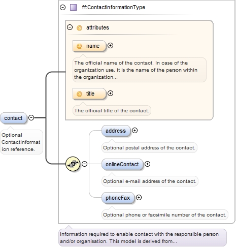
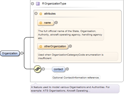
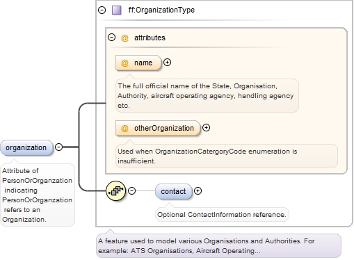
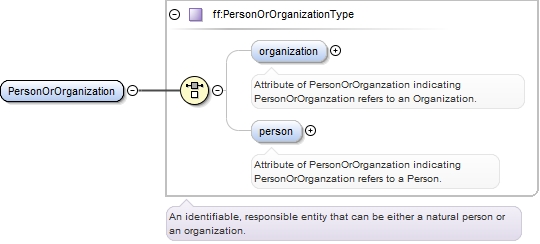
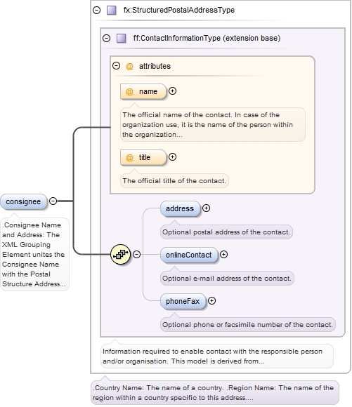
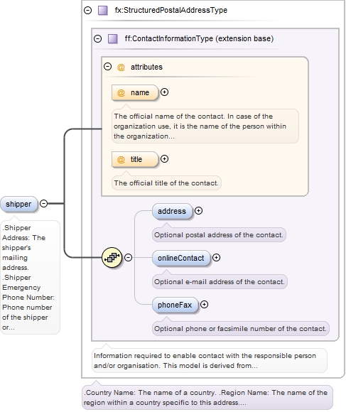
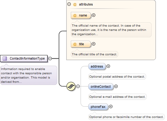
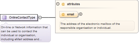
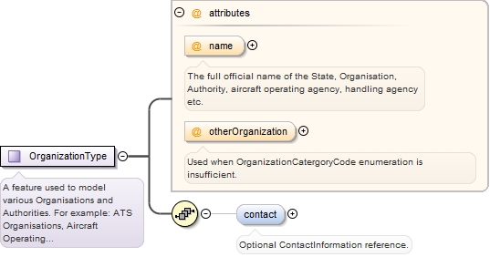
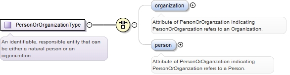
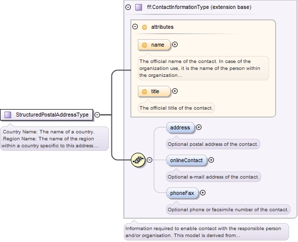
The Foundation.Organization schema contains information about contact information for the responsible person and/or organization.
Copyright (c) 2014 Airservices Australia, EUROCONTROL, JCAB, NATS Limited, NavCanada, SESAR Joint Undertaking & US FAA =========================================== All rights reserved. Redistribution and use in source and binary forms, with or without modification, are permitted provided that the following conditions are met: * Redistributions of source code must retain the above copyright notice, this list of conditions and the disclaimer. * Redistributions in binary form must reproduce the above copyright notice, this list of conditions and the disclaimer in the documentation and/or other materials provided with the distribution. * Neither the names of Airservices Australia, EUROCONTROL, JCAB, NATS Limited, NavCanada, SESAR Joint Undertaking & US FAA nor the names of their contributors may be used to endorse or promote products derived from this specification without specific prior written permission. DISCLAIMER THIS SPECIFICATION IS PROVIDED BY THE COPYRIGHT HOLDERS AND CONTRIBUTORS "AS IS" AND ANY EXPRESS OR IMPLIED WARRANTIES, INCLUDING, BUT NOT LIMITED TO, THE IMPLIED WARRANTIES OF MERCHANTABILITY AND FITNESS FOR A PARTICULAR PURPOSE ARE DISCLAIMED. IN NO EVENT SHALL THE COPYRIGHT OWNER OR CONTRIBUTORS BE LIABLE FOR ANY DIRECT, INDIRECT, INCIDENTAL, SPECIAL, EXEMPLARY, OR CONSEQUENTIAL DAMAGES (INCLUDING, BUT NOT LIMITED TO, PROCUREMENT OF SUBSTITUTE GOODS OR SERVICES; LOSS OF USE, DATA, OR PROFITS; OR BUSINESS INTERRUPTION) HOWEVER CAUSED AND ON ANY THEORY OF LIABILITY, WHETHER IN CONTRACT, STRICT LIABILITY, OR TORT (INCLUDING NEGLIGENCE OR OTHERWISE) ARISING IN ANY WAY OUT OF THE USE OF THIS SOFTWARE, EVEN IF ADVISED OF THE POSSIBILITY OF SUCH DAMAGE. Editorial note: this license is an instance of the BSD license template as provided by the Open Source Initiative: http://www.opensource.org/licenses/bsd-license.php The authoritative reference for FIXM is www.FIXM.aero. Details on Airservices Australia: http://www.airservicesaustralia.com/ Details on EUROCONTROL: http://www.eurocontrol.int/ Details on JCAB: http://www.mlit.go.jp/en/koku/index.html Details on NATS Limited: http://www.nats.co.uk/ Details on NavCanada: http://www.navcanada.ca/ Details on the SESAR JU and its members: http://www.sesarju.eu/players/members Details on the US FAA: http://www.faa.gov/ Details on the US FAA’s NextGen program: http://www.faa.gov/NextGen
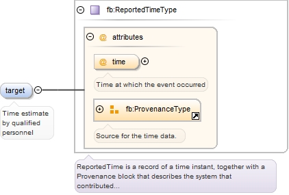
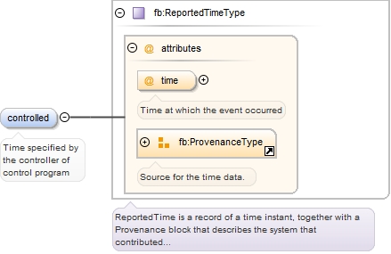
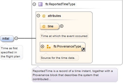
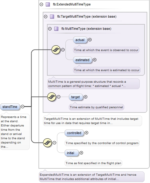
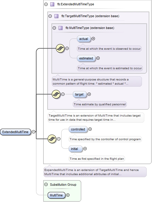
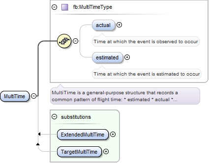
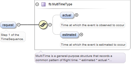
The Foundation.Time schema provides additional representations (beyond Base.Time) for time elements. Schemas should use these representations in preference XSD representations.
Copyright (c) 2014 Airservices Australia, EUROCONTROL, JCAB, NATS Limited, NavCanada, SESAR Joint Undertaking & US FAA =========================================== All rights reserved. Redistribution and use in source and binary forms, with or without modification, are permitted provided that the following conditions are met: * Redistributions of source code must retain the above copyright notice, this list of conditions and the disclaimer. * Redistributions in binary form must reproduce the above copyright notice, this list of conditions and the disclaimer in the documentation and/or other materials provided with the distribution. * Neither the names of Airservices Australia, EUROCONTROL, JCAB, NATS Limited, NavCanada, SESAR Joint Undertaking & US FAA nor the names of their contributors may be used to endorse or promote products derived from this specification without specific prior written permission. DISCLAIMER THIS SPECIFICATION IS PROVIDED BY THE COPYRIGHT HOLDERS AND CONTRIBUTORS "AS IS" AND ANY EXPRESS OR IMPLIED WARRANTIES, INCLUDING, BUT NOT LIMITED TO, THE IMPLIED WARRANTIES OF MERCHANTABILITY AND FITNESS FOR A PARTICULAR PURPOSE ARE DISCLAIMED. IN NO EVENT SHALL THE COPYRIGHT OWNER OR CONTRIBUTORS BE LIABLE FOR ANY DIRECT, INDIRECT, INCIDENTAL, SPECIAL, EXEMPLARY, OR CONSEQUENTIAL DAMAGES (INCLUDING, BUT NOT LIMITED TO, PROCUREMENT OF SUBSTITUTE GOODS OR SERVICES; LOSS OF USE, DATA, OR PROFITS; OR BUSINESS INTERRUPTION) HOWEVER CAUSED AND ON ANY THEORY OF LIABILITY, WHETHER IN CONTRACT, STRICT LIABILITY, OR TORT (INCLUDING NEGLIGENCE OR OTHERWISE) ARISING IN ANY WAY OUT OF THE USE OF THIS SOFTWARE, EVEN IF ADVISED OF THE POSSIBILITY OF SUCH DAMAGE. Editorial note: this license is an instance of the BSD license template as provided by the Open Source Initiative: http://www.opensource.org/licenses/bsd-license.php The authoritative reference for FIXM is www.FIXM.aero. Details on Airservices Australia: http://www.airservicesaustralia.com/ Details on EUROCONTROL: http://www.eurocontrol.int/ Details on JCAB: http://www.mlit.go.jp/en/koku/index.html Details on NATS Limited: http://www.nats.co.uk/ Details on NavCanada: http://www.navcanada.ca/ Details on the SESAR JU and its members: http://www.sesarju.eu/players/members Details on the US FAA: http://www.faa.gov/ Details on the US FAA’s NextGen program: http://www.faa.gov/NextGen
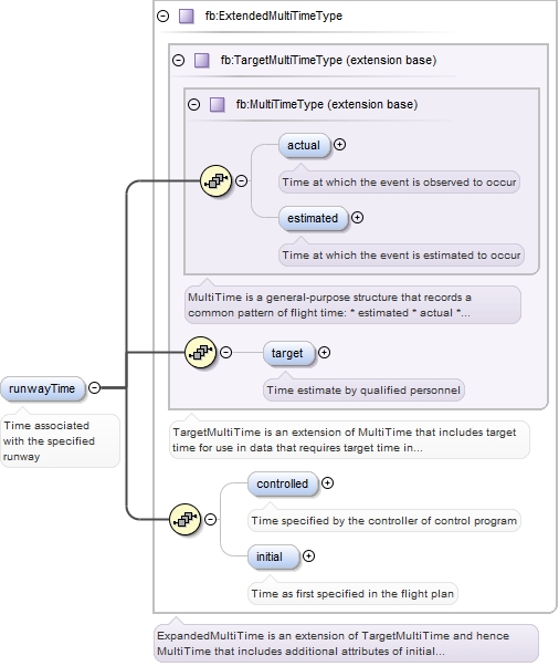
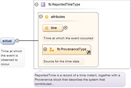
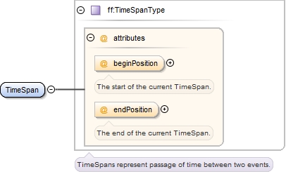
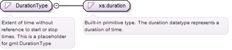
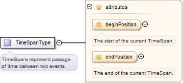
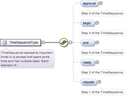
The Base.Time schema provides representations for time elements. Schemas should use these representations in preference XSD representations.
Copyright (c) 2014 Airservices Australia, EUROCONTROL, JCAB, NATS Limited, NavCanada, SESAR Joint Undertaking & US FAA =========================================== All rights reserved. Redistribution and use in source and binary forms, with or without modification, are permitted provided that the following conditions are met: * Redistributions of source code must retain the above copyright notice, this list of conditions and the disclaimer. * Redistributions in binary form must reproduce the above copyright notice, this list of conditions and the disclaimer in the documentation and/or other materials provided with the distribution. * Neither the names of Airservices Australia, EUROCONTROL, JCAB, NATS Limited, NavCanada, SESAR Joint Undertaking & US FAA nor the names of their contributors may be used to endorse or promote products derived from this specification without specific prior written permission. DISCLAIMER THIS SPECIFICATION IS PROVIDED BY THE COPYRIGHT HOLDERS AND CONTRIBUTORS "AS IS" AND ANY EXPRESS OR IMPLIED WARRANTIES, INCLUDING, BUT NOT LIMITED TO, THE IMPLIED WARRANTIES OF MERCHANTABILITY AND FITNESS FOR A PARTICULAR PURPOSE ARE DISCLAIMED. IN NO EVENT SHALL THE COPYRIGHT OWNER OR CONTRIBUTORS BE LIABLE FOR ANY DIRECT, INDIRECT, INCIDENTAL, SPECIAL, EXEMPLARY, OR CONSEQUENTIAL DAMAGES (INCLUDING, BUT NOT LIMITED TO, PROCUREMENT OF SUBSTITUTE GOODS OR SERVICES; LOSS OF USE, DATA, OR PROFITS; OR BUSINESS INTERRUPTION) HOWEVER CAUSED AND ON ANY THEORY OF LIABILITY, WHETHER IN CONTRACT, STRICT LIABILITY, OR TORT (INCLUDING NEGLIGENCE OR OTHERWISE) ARISING IN ANY WAY OUT OF THE USE OF THIS SOFTWARE, EVEN IF ADVISED OF THE POSSIBILITY OF SUCH DAMAGE. Editorial note: this license is an instance of the BSD license template as provided by the Open Source Initiative: http://www.opensource.org/licenses/bsd-license.php The authoritative reference for FIXM is www.FIXM.aero. Details on Airservices Australia: http://www.airservicesaustralia.com/ Details on EUROCONTROL: http://www.eurocontrol.int/ Details on JCAB: http://www.mlit.go.jp/en/koku/index.html Details on NATS Limited: http://www.nats.co.uk/ Details on NavCanada: http://www.navcanada.ca/ Details on the SESAR JU and its members: http://www.sesarju.eu/players/members Details on the US FAA: http://www.faa.gov/ Details on the US FAA’s NextGen program: http://www.faa.gov/NextGen
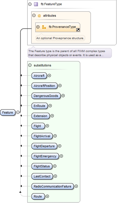
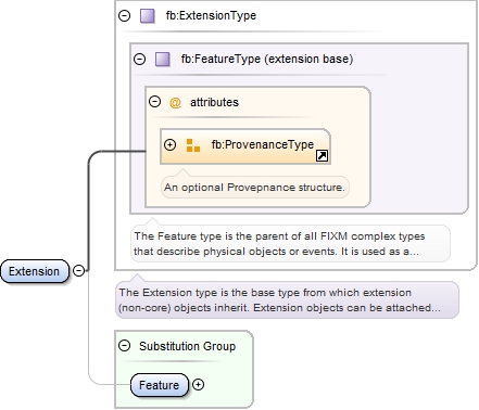
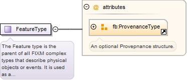
The Base.Feature schema provides representations for all Provenance elements.
Copyright (c) 2014 Airservices Australia, EUROCONTROL, JCAB, NATS Limited, NavCanada, SESAR Joint Undertaking & US FAA =========================================== All rights reserved. Redistribution and use in source and binary forms, with or without modification, are permitted provided that the following conditions are met: * Redistributions of source code must retain the above copyright notice, this list of conditions and the disclaimer. * Redistributions in binary form must reproduce the above copyright notice, this list of conditions and the disclaimer in the documentation and/or other materials provided with the distribution. * Neither the names of Airservices Australia, EUROCONTROL, JCAB, NATS Limited, NavCanada, SESAR Joint Undertaking & US FAA nor the names of their contributors may be used to endorse or promote products derived from this specification without specific prior written permission. DISCLAIMER THIS SPECIFICATION IS PROVIDED BY THE COPYRIGHT HOLDERS AND CONTRIBUTORS "AS IS" AND ANY EXPRESS OR IMPLIED WARRANTIES, INCLUDING, BUT NOT LIMITED TO, THE IMPLIED WARRANTIES OF MERCHANTABILITY AND FITNESS FOR A PARTICULAR PURPOSE ARE DISCLAIMED. IN NO EVENT SHALL THE COPYRIGHT OWNER OR CONTRIBUTORS BE LIABLE FOR ANY DIRECT, INDIRECT, INCIDENTAL, SPECIAL, EXEMPLARY, OR CONSEQUENTIAL DAMAGES (INCLUDING, BUT NOT LIMITED TO, PROCUREMENT OF SUBSTITUTE GOODS OR SERVICES; LOSS OF USE, DATA, OR PROFITS; OR BUSINESS INTERRUPTION) HOWEVER CAUSED AND ON ANY THEORY OF LIABILITY, WHETHER IN CONTRACT, STRICT LIABILITY, OR TORT (INCLUDING NEGLIGENCE OR OTHERWISE) ARISING IN ANY WAY OUT OF THE USE OF THIS SOFTWARE, EVEN IF ADVISED OF THE POSSIBILITY OF SUCH DAMAGE. Editorial note: this license is an instance of the BSD license template as provided by the Open Source Initiative: http://www.opensource.org/licenses/bsd-license.php The authoritative reference for FIXM is www.FIXM.aero. Details on Airservices Australia: http://www.airservicesaustralia.com/ Details on EUROCONTROL: http://www.eurocontrol.int/ Details on JCAB: http://www.mlit.go.jp/en/koku/index.html Details on NATS Limited: http://www.nats.co.uk/ Details on NavCanada: http://www.navcanada.ca/ Details on the SESAR JU and its members: http://www.sesarju.eu/players/members Details on the US FAA: http://www.faa.gov/ Details on the US FAA’s NextGen program: http://www.faa.gov/NextGen
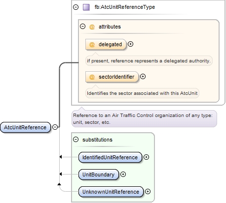
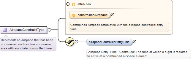
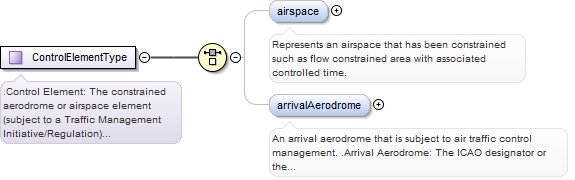
The Base.Airspace schema provides representations for all Air Traffic Control elements.
Copyright (c) 2014 Airservices Australia, EUROCONTROL, JCAB, NATS Limited, NavCanada, SESAR Joint Undertaking & US FAA =========================================== All rights reserved. Redistribution and use in source and binary forms, with or without modification, are permitted provided that the following conditions are met: * Redistributions of source code must retain the above copyright notice, this list of conditions and the disclaimer. * Redistributions in binary form must reproduce the above copyright notice, this list of conditions and the disclaimer in the documentation and/or other materials provided with the distribution. * Neither the names of Airservices Australia, EUROCONTROL, JCAB, NATS Limited, NavCanada, SESAR Joint Undertaking & US FAA nor the names of their contributors may be used to endorse or promote products derived from this specification without specific prior written permission. DISCLAIMER THIS SPECIFICATION IS PROVIDED BY THE COPYRIGHT HOLDERS AND CONTRIBUTORS "AS IS" AND ANY EXPRESS OR IMPLIED WARRANTIES, INCLUDING, BUT NOT LIMITED TO, THE IMPLIED WARRANTIES OF MERCHANTABILITY AND FITNESS FOR A PARTICULAR PURPOSE ARE DISCLAIMED. IN NO EVENT SHALL THE COPYRIGHT OWNER OR CONTRIBUTORS BE LIABLE FOR ANY DIRECT, INDIRECT, INCIDENTAL, SPECIAL, EXEMPLARY, OR CONSEQUENTIAL DAMAGES (INCLUDING, BUT NOT LIMITED TO, PROCUREMENT OF SUBSTITUTE GOODS OR SERVICES; LOSS OF USE, DATA, OR PROFITS; OR BUSINESS INTERRUPTION) HOWEVER CAUSED AND ON ANY THEORY OF LIABILITY, WHETHER IN CONTRACT, STRICT LIABILITY, OR TORT (INCLUDING NEGLIGENCE OR OTHERWISE) ARISING IN ANY WAY OUT OF THE USE OF THIS SOFTWARE, EVEN IF ADVISED OF THE POSSIBILITY OF SUCH DAMAGE. Editorial note: this license is an instance of the BSD license template as provided by the Open Source Initiative: http://www.opensource.org/licenses/bsd-license.php The authoritative reference for FIXM is www.FIXM.aero. Details on Airservices Australia: http://www.airservicesaustralia.com/ Details on EUROCONTROL: http://www.eurocontrol.int/ Details on JCAB: http://www.mlit.go.jp/en/koku/index.html Details on NATS Limited: http://www.nats.co.uk/ Details on NavCanada: http://www.navcanada.ca/ Details on the SESAR JU and its members: http://www.sesarju.eu/players/members Details on the US FAA: http://www.faa.gov/ Details on the US FAA’s NextGen program: http://www.faa.gov/NextGen
The Base.Types schema provides representations for various elements not belonging in another schema.
Copyright (c) 2014 Airservices Australia, EUROCONTROL, JCAB, NATS Limited, NavCanada, SESAR Joint Undertaking & US FAA =========================================== All rights reserved. Redistribution and use in source and binary forms, with or without modification, are permitted provided that the following conditions are met: * Redistributions of source code must retain the above copyright notice, this list of conditions and the disclaimer. * Redistributions in binary form must reproduce the above copyright notice, this list of conditions and the disclaimer in the documentation and/or other materials provided with the distribution. * Neither the names of Airservices Australia, EUROCONTROL, JCAB, NATS Limited, NavCanada, SESAR Joint Undertaking & US FAA nor the names of their contributors may be used to endorse or promote products derived from this specification without specific prior written permission. DISCLAIMER THIS SPECIFICATION IS PROVIDED BY THE COPYRIGHT HOLDERS AND CONTRIBUTORS "AS IS" AND ANY EXPRESS OR IMPLIED WARRANTIES, INCLUDING, BUT NOT LIMITED TO, THE IMPLIED WARRANTIES OF MERCHANTABILITY AND FITNESS FOR A PARTICULAR PURPOSE ARE DISCLAIMED. IN NO EVENT SHALL THE COPYRIGHT OWNER OR CONTRIBUTORS BE LIABLE FOR ANY DIRECT, INDIRECT, INCIDENTAL, SPECIAL, EXEMPLARY, OR CONSEQUENTIAL DAMAGES (INCLUDING, BUT NOT LIMITED TO, PROCUREMENT OF SUBSTITUTE GOODS OR SERVICES; LOSS OF USE, DATA, OR PROFITS; OR BUSINESS INTERRUPTION) HOWEVER CAUSED AND ON ANY THEORY OF LIABILITY, WHETHER IN CONTRACT, STRICT LIABILITY, OR TORT (INCLUDING NEGLIGENCE OR OTHERWISE) ARISING IN ANY WAY OUT OF THE USE OF THIS SOFTWARE, EVEN IF ADVISED OF THE POSSIBILITY OF SUCH DAMAGE. Editorial note: this license is an instance of the BSD license template as provided by the Open Source Initiative: http://www.opensource.org/licenses/bsd-license.php The authoritative reference for FIXM is www.FIXM.aero. Details on Airservices Australia: http://www.airservicesaustralia.com/ Details on EUROCONTROL: http://www.eurocontrol.int/ Details on JCAB: http://www.mlit.go.jp/en/koku/index.html Details on NATS Limited: http://www.nats.co.uk/ Details on NavCanada: http://www.navcanada.ca/ Details on the SESAR JU and its members: http://www.sesarju.eu/players/members Details on the US FAA: http://www.faa.gov/ Details on the US FAA’s NextGen program: http://www.faa.gov/NextGen
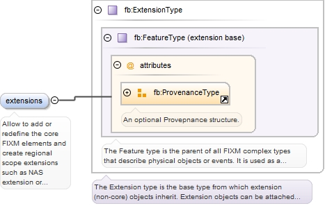
Contains all the classes needed to construct extensions to the FIXM model.
Copyright (c) 2014 Airservices Australia, EUROCONTROL, JCAB, NATS Limited, NavCanada, SESAR Joint Undertaking & US FAA =========================================== All rights reserved. Redistribution and use in source and binary forms, with or without modification, are permitted provided that the following conditions are met: * Redistributions of source code must retain the above copyright notice, this list of conditions and the disclaimer. * Redistributions in binary form must reproduce the above copyright notice, this list of conditions and the disclaimer in the documentation and/or other materials provided with the distribution. * Neither the names of Airservices Australia, EUROCONTROL, JCAB, NATS Limited, NavCanada, SESAR Joint Undertaking & US FAA nor the names of their contributors may be used to endorse or promote products derived from this specification without specific prior written permission. DISCLAIMER THIS SPECIFICATION IS PROVIDED BY THE COPYRIGHT HOLDERS AND CONTRIBUTORS "AS IS" AND ANY EXPRESS OR IMPLIED WARRANTIES, INCLUDING, BUT NOT LIMITED TO, THE IMPLIED WARRANTIES OF MERCHANTABILITY AND FITNESS FOR A PARTICULAR PURPOSE ARE DISCLAIMED. IN NO EVENT SHALL THE COPYRIGHT OWNER OR CONTRIBUTORS BE LIABLE FOR ANY DIRECT, INDIRECT, INCIDENTAL, SPECIAL, EXEMPLARY, OR CONSEQUENTIAL DAMAGES (INCLUDING, BUT NOT LIMITED TO, PROCUREMENT OF SUBSTITUTE GOODS OR SERVICES; LOSS OF USE, DATA, OR PROFITS; OR BUSINESS INTERRUPTION) HOWEVER CAUSED AND ON ANY THEORY OF LIABILITY, WHETHER IN CONTRACT, STRICT LIABILITY, OR TORT (INCLUDING NEGLIGENCE OR OTHERWISE) ARISING IN ANY WAY OUT OF THE USE OF THIS SOFTWARE, EVEN IF ADVISED OF THE POSSIBILITY OF SUCH DAMAGE. Editorial note: this license is an instance of the BSD license template as provided by the Open Source Initiative: http://www.opensource.org/licenses/bsd-license.php The authoritative reference for FIXM is www.FIXM.aero. Details on Airservices Australia: http://www.airservicesaustralia.com/ Details on EUROCONTROL: http://www.eurocontrol.int/ Details on JCAB: http://www.mlit.go.jp/en/koku/index.html Details on NATS Limited: http://www.nats.co.uk/ Details on NavCanada: http://www.navcanada.ca/ Details on the SESAR JU and its members: http://www.sesarju.eu/players/members Details on the US FAA: http://www.faa.gov/ Details on the US FAA’s NextGen program: http://www.faa.gov/NextGen
Copyright (c) 2014 Airservices Australia, EUROCONTROL, JCAB, NATS Limited, NavCanada, SESAR Joint Undertaking & US FAA =========================================== All rights reserved. Redistribution and use in source and binary forms, with or without modification, are permitted provided that the following conditions are met: * Redistributions of source code must retain the above copyright notice, this list of conditions and the disclaimer. * Redistributions in binary form must reproduce the above copyright notice, this list of conditions and the disclaimer in the documentation and/or other materials provided with the distribution. * Neither the names of Airservices Australia, EUROCONTROL, JCAB, NATS Limited, NavCanada, SESAR Joint Undertaking & US FAA nor the names of their contributors may be used to endorse or promote products derived from this specification without specific prior written permission. DISCLAIMER THIS SPECIFICATION IS PROVIDED BY THE COPYRIGHT HOLDERS AND CONTRIBUTORS "AS IS" AND ANY EXPRESS OR IMPLIED WARRANTIES, INCLUDING, BUT NOT LIMITED TO, THE IMPLIED WARRANTIES OF MERCHANTABILITY AND FITNESS FOR A PARTICULAR PURPOSE ARE DISCLAIMED. IN NO EVENT SHALL THE COPYRIGHT OWNER OR CONTRIBUTORS BE LIABLE FOR ANY DIRECT, INDIRECT, INCIDENTAL, SPECIAL, EXEMPLARY, OR CONSEQUENTIAL DAMAGES (INCLUDING, BUT NOT LIMITED TO, PROCUREMENT OF SUBSTITUTE GOODS OR SERVICES; LOSS OF USE, DATA, OR PROFITS; OR BUSINESS INTERRUPTION) HOWEVER CAUSED AND ON ANY THEORY OF LIABILITY, WHETHER IN CONTRACT, STRICT LIABILITY, OR TORT (INCLUDING NEGLIGENCE OR OTHERWISE) ARISING IN ANY WAY OUT OF THE USE OF THIS SOFTWARE, EVEN IF ADVISED OF THE POSSIBILITY OF SUCH DAMAGE. Editorial note: this license is an instance of the BSD license template as provided by the Open Source Initiative: http://www.opensource.org/licenses/bsd-license.php The authoritative reference for FIXM is www.FIXM.aero. Details on Airservices Australia: http://www.airservicesaustralia.com/ Details on EUROCONTROL: http://www.eurocontrol.int/ Details on JCAB: http://www.mlit.go.jp/en/koku/index.html Details on NATS Limited: http://www.nats.co.uk/ Details on NavCanada: http://www.navcanada.ca/ Details on the SESAR JU and its members: http://www.sesarju.eu/players/members Details on the US FAA: http://www.faa.gov/ Details on the US FAA’s NextGen program: http://www.faa.gov/NextGen
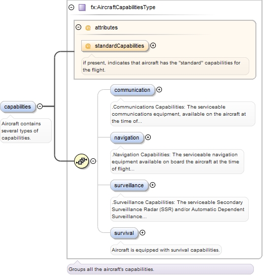
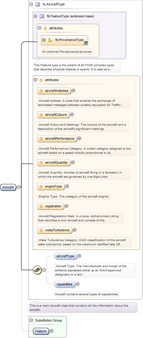
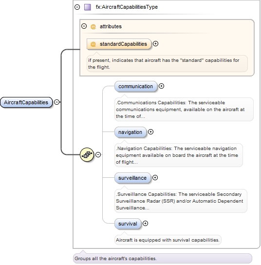
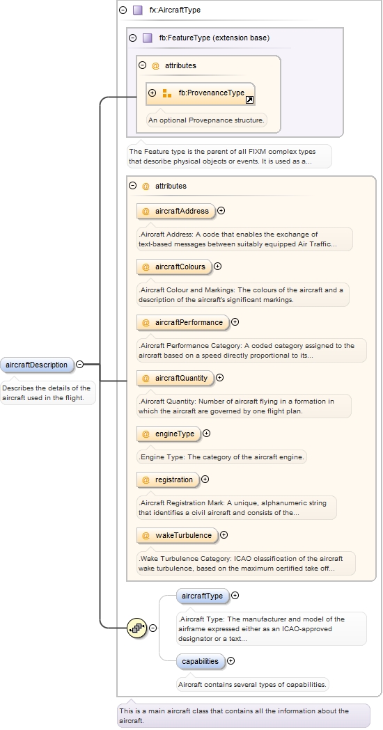
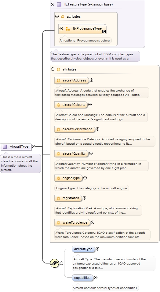
The aircraft package describes the details about the aircraft that is used for the flight including all capabilities that the aircraft has.
Copyright (c) 2014 Airservices Australia, EUROCONTROL, JCAB, NATS Limited, NavCanada, SESAR Joint Undertaking & US FAA =========================================== All rights reserved. Redistribution and use in source and binary forms, with or without modification, are permitted provided that the following conditions are met: * Redistributions of source code must retain the above copyright notice, this list of conditions and the disclaimer. * Redistributions in binary form must reproduce the above copyright notice, this list of conditions and the disclaimer in the documentation and/or other materials provided with the distribution. * Neither the names of Airservices Australia, EUROCONTROL, JCAB, NATS Limited, NavCanada, SESAR Joint Undertaking & US FAA nor the names of their contributors may be used to endorse or promote products derived from this specification without specific prior written permission. DISCLAIMER THIS SPECIFICATION IS PROVIDED BY THE COPYRIGHT HOLDERS AND CONTRIBUTORS "AS IS" AND ANY EXPRESS OR IMPLIED WARRANTIES, INCLUDING, BUT NOT LIMITED TO, THE IMPLIED WARRANTIES OF MERCHANTABILITY AND FITNESS FOR A PARTICULAR PURPOSE ARE DISCLAIMED. IN NO EVENT SHALL THE COPYRIGHT OWNER OR CONTRIBUTORS BE LIABLE FOR ANY DIRECT, INDIRECT, INCIDENTAL, SPECIAL, EXEMPLARY, OR CONSEQUENTIAL DAMAGES (INCLUDING, BUT NOT LIMITED TO, PROCUREMENT OF SUBSTITUTE GOODS OR SERVICES; LOSS OF USE, DATA, OR PROFITS; OR BUSINESS INTERRUPTION) HOWEVER CAUSED AND ON ANY THEORY OF LIABILITY, WHETHER IN CONTRACT, STRICT LIABILITY, OR TORT (INCLUDING NEGLIGENCE OR OTHERWISE) ARISING IN ANY WAY OUT OF THE USE OF THIS SOFTWARE, EVEN IF ADVISED OF THE POSSIBILITY OF SUCH DAMAGE. Editorial note: this license is an instance of the BSD license template as provided by the Open Source Initiative: http://www.opensource.org/licenses/bsd-license.php The authoritative reference for FIXM is www.FIXM.aero. Details on Airservices Australia: http://www.airservicesaustralia.com/ Details on EUROCONTROL: http://www.eurocontrol.int/ Details on JCAB: http://www.mlit.go.jp/en/koku/index.html Details on NATS Limited: http://www.nats.co.uk/ Details on NavCanada: http://www.navcanada.ca/ Details on the SESAR JU and its members: http://www.sesarju.eu/players/members Details on the US FAA: http://www.faa.gov/ Details on the US FAA’s NextGen program: http://www.faa.gov/NextGen
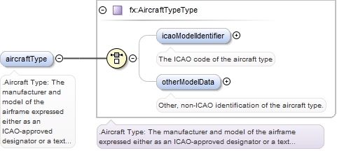
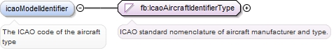
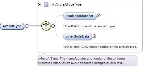
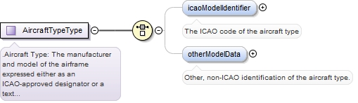
This package contains information about the aircraft type.
Copyright (c) 2014 Airservices Australia, EUROCONTROL, JCAB, NATS Limited, NavCanada, SESAR Joint Undertaking & US FAA =========================================== All rights reserved. Redistribution and use in source and binary forms, with or without modification, are permitted provided that the following conditions are met: * Redistributions of source code must retain the above copyright notice, this list of conditions and the disclaimer. * Redistributions in binary form must reproduce the above copyright notice, this list of conditions and the disclaimer in the documentation and/or other materials provided with the distribution. * Neither the names of Airservices Australia, EUROCONTROL, JCAB, NATS Limited, NavCanada, SESAR Joint Undertaking & US FAA nor the names of their contributors may be used to endorse or promote products derived from this specification without specific prior written permission. DISCLAIMER THIS SPECIFICATION IS PROVIDED BY THE COPYRIGHT HOLDERS AND CONTRIBUTORS "AS IS" AND ANY EXPRESS OR IMPLIED WARRANTIES, INCLUDING, BUT NOT LIMITED TO, THE IMPLIED WARRANTIES OF MERCHANTABILITY AND FITNESS FOR A PARTICULAR PURPOSE ARE DISCLAIMED. IN NO EVENT SHALL THE COPYRIGHT OWNER OR CONTRIBUTORS BE LIABLE FOR ANY DIRECT, INDIRECT, INCIDENTAL, SPECIAL, EXEMPLARY, OR CONSEQUENTIAL DAMAGES (INCLUDING, BUT NOT LIMITED TO, PROCUREMENT OF SUBSTITUTE GOODS OR SERVICES; LOSS OF USE, DATA, OR PROFITS; OR BUSINESS INTERRUPTION) HOWEVER CAUSED AND ON ANY THEORY OF LIABILITY, WHETHER IN CONTRACT, STRICT LIABILITY, OR TORT (INCLUDING NEGLIGENCE OR OTHERWISE) ARISING IN ANY WAY OUT OF THE USE OF THIS SOFTWARE, EVEN IF ADVISED OF THE POSSIBILITY OF SUCH DAMAGE. Editorial note: this license is an instance of the BSD license template as provided by the Open Source Initiative: http://www.opensource.org/licenses/bsd-license.php The authoritative reference for FIXM is www.FIXM.aero. Details on Airservices Australia: http://www.airservicesaustralia.com/ Details on EUROCONTROL: http://www.eurocontrol.int/ Details on JCAB: http://www.mlit.go.jp/en/koku/index.html Details on NATS Limited: http://www.nats.co.uk/ Details on NavCanada: http://www.navcanada.ca/ Details on the SESAR JU and its members: http://www.sesarju.eu/players/members Details on the US FAA: http://www.faa.gov/ Details on the US FAA’s NextGen program: http://www.faa.gov/NextGen
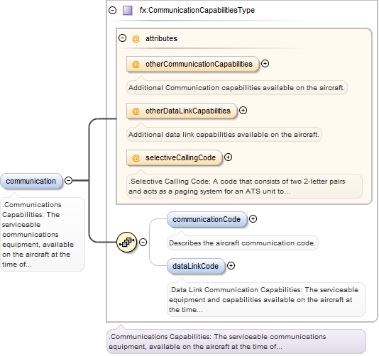
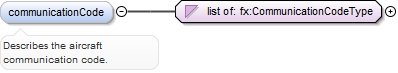
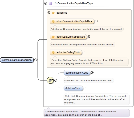
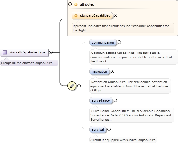
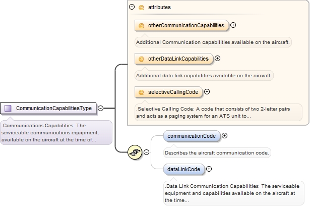
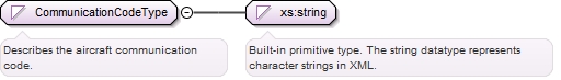
This package contains information about the aircraft's communication capabilities equipment.
Copyright (c) 2014 Airservices Australia, EUROCONTROL, JCAB, NATS Limited, NavCanada, SESAR Joint Undertaking & US FAA =========================================== All rights reserved. Redistribution and use in source and binary forms, with or without modification, are permitted provided that the following conditions are met: * Redistributions of source code must retain the above copyright notice, this list of conditions and the disclaimer. * Redistributions in binary form must reproduce the above copyright notice, this list of conditions and the disclaimer in the documentation and/or other materials provided with the distribution. * Neither the names of Airservices Australia, EUROCONTROL, JCAB, NATS Limited, NavCanada, SESAR Joint Undertaking & US FAA nor the names of their contributors may be used to endorse or promote products derived from this specification without specific prior written permission. DISCLAIMER THIS SPECIFICATION IS PROVIDED BY THE COPYRIGHT HOLDERS AND CONTRIBUTORS "AS IS" AND ANY EXPRESS OR IMPLIED WARRANTIES, INCLUDING, BUT NOT LIMITED TO, THE IMPLIED WARRANTIES OF MERCHANTABILITY AND FITNESS FOR A PARTICULAR PURPOSE ARE DISCLAIMED. IN NO EVENT SHALL THE COPYRIGHT OWNER OR CONTRIBUTORS BE LIABLE FOR ANY DIRECT, INDIRECT, INCIDENTAL, SPECIAL, EXEMPLARY, OR CONSEQUENTIAL DAMAGES (INCLUDING, BUT NOT LIMITED TO, PROCUREMENT OF SUBSTITUTE GOODS OR SERVICES; LOSS OF USE, DATA, OR PROFITS; OR BUSINESS INTERRUPTION) HOWEVER CAUSED AND ON ANY THEORY OF LIABILITY, WHETHER IN CONTRACT, STRICT LIABILITY, OR TORT (INCLUDING NEGLIGENCE OR OTHERWISE) ARISING IN ANY WAY OUT OF THE USE OF THIS SOFTWARE, EVEN IF ADVISED OF THE POSSIBILITY OF SUCH DAMAGE. Editorial note: this license is an instance of the BSD license template as provided by the Open Source Initiative: http://www.opensource.org/licenses/bsd-license.php The authoritative reference for FIXM is www.FIXM.aero. Details on Airservices Australia: http://www.airservicesaustralia.com/ Details on EUROCONTROL: http://www.eurocontrol.int/ Details on JCAB: http://www.mlit.go.jp/en/koku/index.html Details on NATS Limited: http://www.nats.co.uk/ Details on NavCanada: http://www.navcanada.ca/ Details on the SESAR JU and its members: http://www.sesarju.eu/players/members Details on the US FAA: http://www.faa.gov/ Details on the US FAA’s NextGen program: http://www.faa.gov/NextGen
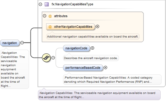
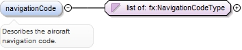
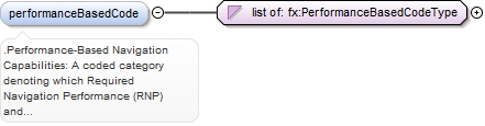
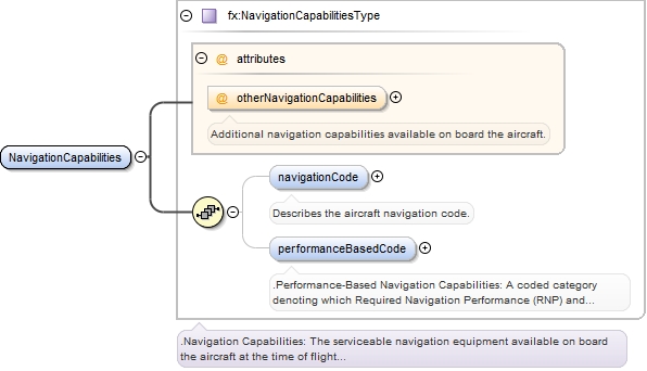
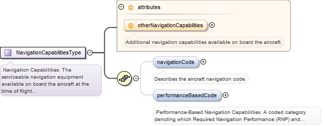
Contains information about the aircraft's navigational capabilities equipment.
Copyright (c) 2014 Airservices Australia, EUROCONTROL, JCAB, NATS Limited, NavCanada, SESAR Joint Undertaking & US FAA =========================================== All rights reserved. Redistribution and use in source and binary forms, with or without modification, are permitted provided that the following conditions are met: * Redistributions of source code must retain the above copyright notice, this list of conditions and the disclaimer. * Redistributions in binary form must reproduce the above copyright notice, this list of conditions and the disclaimer in the documentation and/or other materials provided with the distribution. * Neither the names of Airservices Australia, EUROCONTROL, JCAB, NATS Limited, NavCanada, SESAR Joint Undertaking & US FAA nor the names of their contributors may be used to endorse or promote products derived from this specification without specific prior written permission. DISCLAIMER THIS SPECIFICATION IS PROVIDED BY THE COPYRIGHT HOLDERS AND CONTRIBUTORS "AS IS" AND ANY EXPRESS OR IMPLIED WARRANTIES, INCLUDING, BUT NOT LIMITED TO, THE IMPLIED WARRANTIES OF MERCHANTABILITY AND FITNESS FOR A PARTICULAR PURPOSE ARE DISCLAIMED. IN NO EVENT SHALL THE COPYRIGHT OWNER OR CONTRIBUTORS BE LIABLE FOR ANY DIRECT, INDIRECT, INCIDENTAL, SPECIAL, EXEMPLARY, OR CONSEQUENTIAL DAMAGES (INCLUDING, BUT NOT LIMITED TO, PROCUREMENT OF SUBSTITUTE GOODS OR SERVICES; LOSS OF USE, DATA, OR PROFITS; OR BUSINESS INTERRUPTION) HOWEVER CAUSED AND ON ANY THEORY OF LIABILITY, WHETHER IN CONTRACT, STRICT LIABILITY, OR TORT (INCLUDING NEGLIGENCE OR OTHERWISE) ARISING IN ANY WAY OUT OF THE USE OF THIS SOFTWARE, EVEN IF ADVISED OF THE POSSIBILITY OF SUCH DAMAGE. Editorial note: this license is an instance of the BSD license template as provided by the Open Source Initiative: http://www.opensource.org/licenses/bsd-license.php The authoritative reference for FIXM is www.FIXM.aero. Details on Airservices Australia: http://www.airservicesaustralia.com/ Details on EUROCONTROL: http://www.eurocontrol.int/ Details on JCAB: http://www.mlit.go.jp/en/koku/index.html Details on NATS Limited: http://www.nats.co.uk/ Details on NavCanada: http://www.navcanada.ca/ Details on the SESAR JU and its members: http://www.sesarju.eu/players/members Details on the US FAA: http://www.faa.gov/ Details on the US FAA’s NextGen program: http://www.faa.gov/NextGen
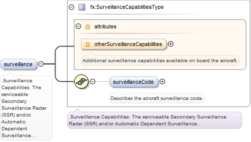
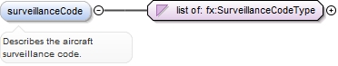
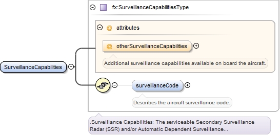
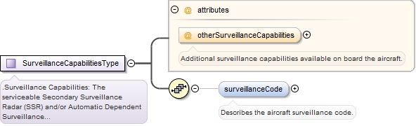
Contains information about the aircraft's surveillance capabilities equipment.
Copyright (c) 2014 Airservices Australia, EUROCONTROL, JCAB, NATS Limited, NavCanada, SESAR Joint Undertaking & US FAA =========================================== All rights reserved. Redistribution and use in source and binary forms, with or without modification, are permitted provided that the following conditions are met: * Redistributions of source code must retain the above copyright notice, this list of conditions and the disclaimer. * Redistributions in binary form must reproduce the above copyright notice, this list of conditions and the disclaimer in the documentation and/or other materials provided with the distribution. * Neither the names of Airservices Australia, EUROCONTROL, JCAB, NATS Limited, NavCanada, SESAR Joint Undertaking & US FAA nor the names of their contributors may be used to endorse or promote products derived from this specification without specific prior written permission. DISCLAIMER THIS SPECIFICATION IS PROVIDED BY THE COPYRIGHT HOLDERS AND CONTRIBUTORS "AS IS" AND ANY EXPRESS OR IMPLIED WARRANTIES, INCLUDING, BUT NOT LIMITED TO, THE IMPLIED WARRANTIES OF MERCHANTABILITY AND FITNESS FOR A PARTICULAR PURPOSE ARE DISCLAIMED. IN NO EVENT SHALL THE COPYRIGHT OWNER OR CONTRIBUTORS BE LIABLE FOR ANY DIRECT, INDIRECT, INCIDENTAL, SPECIAL, EXEMPLARY, OR CONSEQUENTIAL DAMAGES (INCLUDING, BUT NOT LIMITED TO, PROCUREMENT OF SUBSTITUTE GOODS OR SERVICES; LOSS OF USE, DATA, OR PROFITS; OR BUSINESS INTERRUPTION) HOWEVER CAUSED AND ON ANY THEORY OF LIABILITY, WHETHER IN CONTRACT, STRICT LIABILITY, OR TORT (INCLUDING NEGLIGENCE OR OTHERWISE) ARISING IN ANY WAY OUT OF THE USE OF THIS SOFTWARE, EVEN IF ADVISED OF THE POSSIBILITY OF SUCH DAMAGE. Editorial note: this license is an instance of the BSD license template as provided by the Open Source Initiative: http://www.opensource.org/licenses/bsd-license.php The authoritative reference for FIXM is www.FIXM.aero. Details on Airservices Australia: http://www.airservicesaustralia.com/ Details on EUROCONTROL: http://www.eurocontrol.int/ Details on JCAB: http://www.mlit.go.jp/en/koku/index.html Details on NATS Limited: http://www.nats.co.uk/ Details on NavCanada: http://www.navcanada.ca/ Details on the SESAR JU and its members: http://www.sesarju.eu/players/members Details on the US FAA: http://www.faa.gov/ Details on the US FAA’s NextGen program: http://www.faa.gov/NextGen
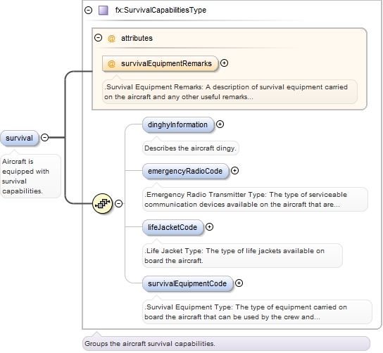
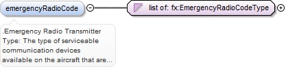
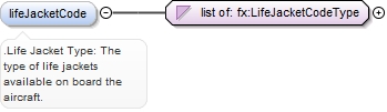
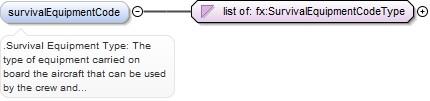
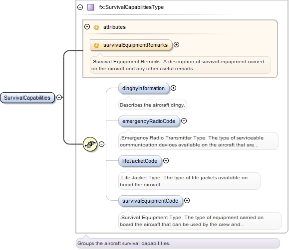
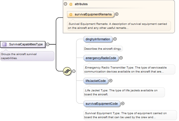
Contains information about the aircraft's survival capabilities equipment.
Copyright (c) 2014 Airservices Australia, EUROCONTROL, JCAB, NATS Limited, NavCanada, SESAR Joint Undertaking & US FAA =========================================== All rights reserved. Redistribution and use in source and binary forms, with or without modification, are permitted provided that the following conditions are met: * Redistributions of source code must retain the above copyright notice, this list of conditions and the disclaimer. * Redistributions in binary form must reproduce the above copyright notice, this list of conditions and the disclaimer in the documentation and/or other materials provided with the distribution. * Neither the names of Airservices Australia, EUROCONTROL, JCAB, NATS Limited, NavCanada, SESAR Joint Undertaking & US FAA nor the names of their contributors may be used to endorse or promote products derived from this specification without specific prior written permission. DISCLAIMER THIS SPECIFICATION IS PROVIDED BY THE COPYRIGHT HOLDERS AND CONTRIBUTORS "AS IS" AND ANY EXPRESS OR IMPLIED WARRANTIES, INCLUDING, BUT NOT LIMITED TO, THE IMPLIED WARRANTIES OF MERCHANTABILITY AND FITNESS FOR A PARTICULAR PURPOSE ARE DISCLAIMED. IN NO EVENT SHALL THE COPYRIGHT OWNER OR CONTRIBUTORS BE LIABLE FOR ANY DIRECT, INDIRECT, INCIDENTAL, SPECIAL, EXEMPLARY, OR CONSEQUENTIAL DAMAGES (INCLUDING, BUT NOT LIMITED TO, PROCUREMENT OF SUBSTITUTE GOODS OR SERVICES; LOSS OF USE, DATA, OR PROFITS; OR BUSINESS INTERRUPTION) HOWEVER CAUSED AND ON ANY THEORY OF LIABILITY, WHETHER IN CONTRACT, STRICT LIABILITY, OR TORT (INCLUDING NEGLIGENCE OR OTHERWISE) ARISING IN ANY WAY OUT OF THE USE OF THIS SOFTWARE, EVEN IF ADVISED OF THE POSSIBILITY OF SUCH DAMAGE. Editorial note: this license is an instance of the BSD license template as provided by the Open Source Initiative: http://www.opensource.org/licenses/bsd-license.php The authoritative reference for FIXM is www.FIXM.aero. Details on Airservices Australia: http://www.airservicesaustralia.com/ Details on EUROCONTROL: http://www.eurocontrol.int/ Details on JCAB: http://www.mlit.go.jp/en/koku/index.html Details on NATS Limited: http://www.nats.co.uk/ Details on NavCanada: http://www.navcanada.ca/ Details on the SESAR JU and its members: http://www.sesarju.eu/players/members Details on the US FAA: http://www.faa.gov/ Details on the US FAA’s NextGen program: http://www.faa.gov/NextGen
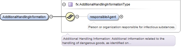
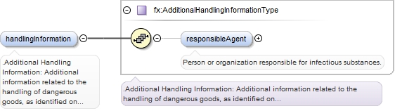
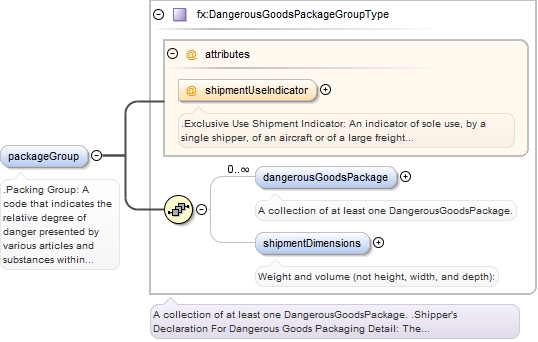
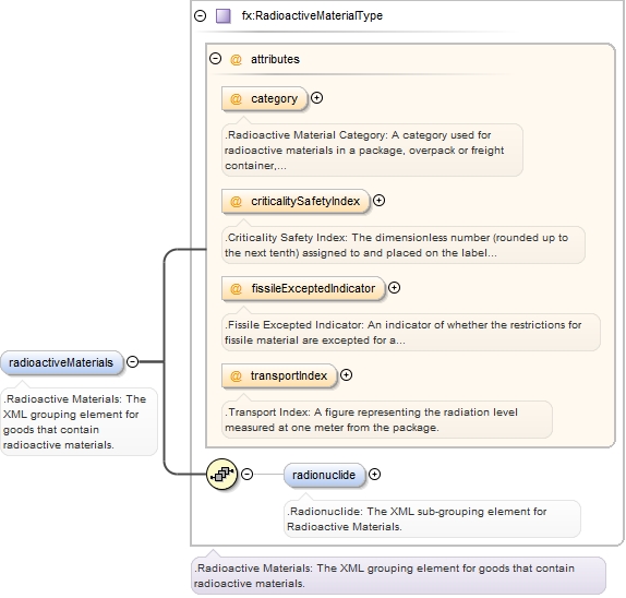
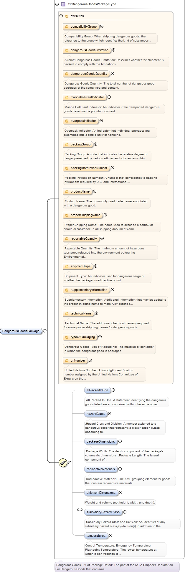
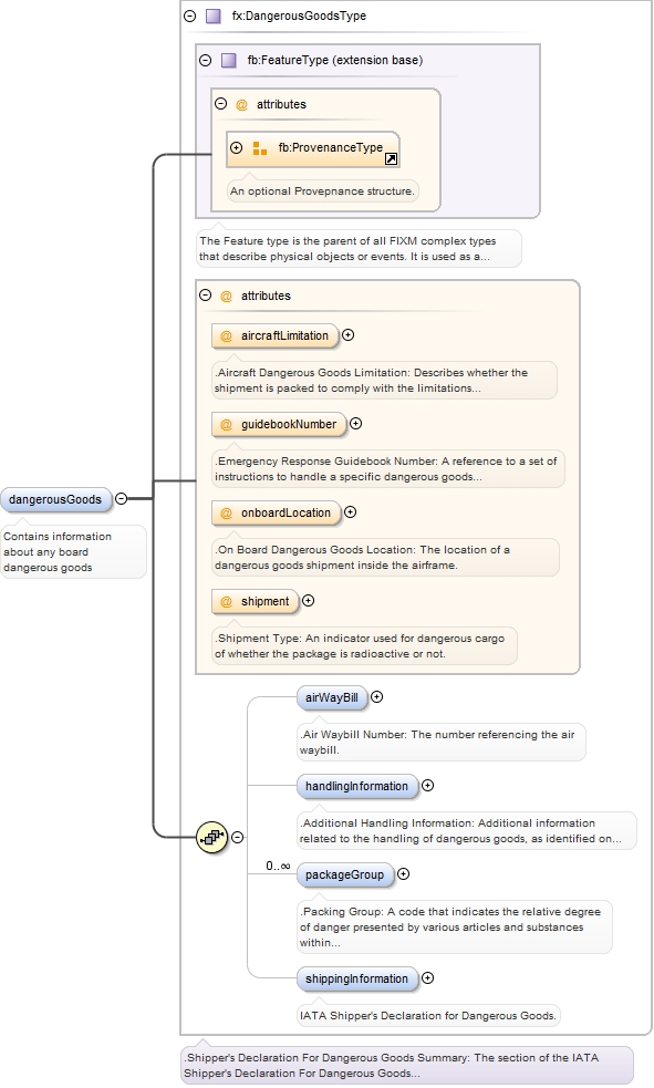
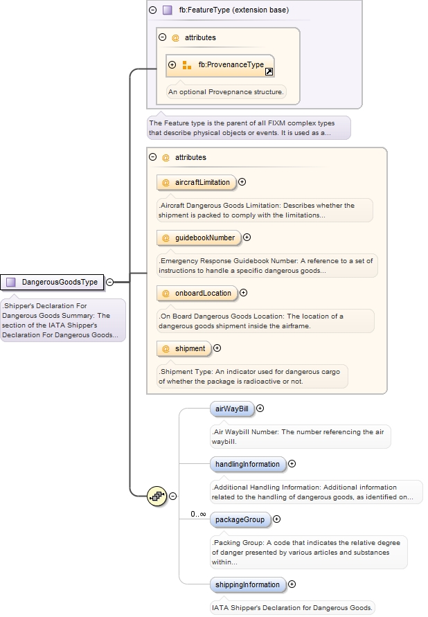
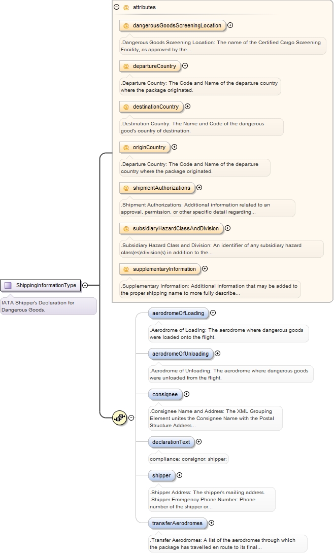
Package containing schemas for DangerousGoods, Packaging, and RadioactiveMaterials,
Copyright (c) 2014 Airservices Australia, EUROCONTROL, JCAB, NATS Limited, NavCanada, SESAR Joint Undertaking & US FAA =========================================== All rights reserved. Redistribution and use in source and binary forms, with or without modification, are permitted provided that the following conditions are met: * Redistributions of source code must retain the above copyright notice, this list of conditions and the disclaimer. * Redistributions in binary form must reproduce the above copyright notice, this list of conditions and the disclaimer in the documentation and/or other materials provided with the distribution. * Neither the names of Airservices Australia, EUROCONTROL, JCAB, NATS Limited, NavCanada, SESAR Joint Undertaking & US FAA nor the names of their contributors may be used to endorse or promote products derived from this specification without specific prior written permission. DISCLAIMER THIS SPECIFICATION IS PROVIDED BY THE COPYRIGHT HOLDERS AND CONTRIBUTORS "AS IS" AND ANY EXPRESS OR IMPLIED WARRANTIES, INCLUDING, BUT NOT LIMITED TO, THE IMPLIED WARRANTIES OF MERCHANTABILITY AND FITNESS FOR A PARTICULAR PURPOSE ARE DISCLAIMED. IN NO EVENT SHALL THE COPYRIGHT OWNER OR CONTRIBUTORS BE LIABLE FOR ANY DIRECT, INDIRECT, INCIDENTAL, SPECIAL, EXEMPLARY, OR CONSEQUENTIAL DAMAGES (INCLUDING, BUT NOT LIMITED TO, PROCUREMENT OF SUBSTITUTE GOODS OR SERVICES; LOSS OF USE, DATA, OR PROFITS; OR BUSINESS INTERRUPTION) HOWEVER CAUSED AND ON ANY THEORY OF LIABILITY, WHETHER IN CONTRACT, STRICT LIABILITY, OR TORT (INCLUDING NEGLIGENCE OR OTHERWISE) ARISING IN ANY WAY OUT OF THE USE OF THIS SOFTWARE, EVEN IF ADVISED OF THE POSSIBILITY OF SUCH DAMAGE. Editorial note: this license is an instance of the BSD license template as provided by the Open Source Initiative: http://www.opensource.org/licenses/bsd-license.php The authoritative reference for FIXM is www.FIXM.aero. Details on Airservices Australia: http://www.airservicesaustralia.com/ Details on EUROCONTROL: http://www.eurocontrol.int/ Details on JCAB: http://www.mlit.go.jp/en/koku/index.html Details on NATS Limited: http://www.nats.co.uk/ Details on NavCanada: http://www.navcanada.ca/ Details on the SESAR JU and its members: http://www.sesarju.eu/players/members Details on the US FAA: http://www.faa.gov/ Details on the US FAA’s NextGen program: http://www.faa.gov/NextGen
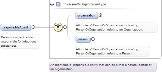
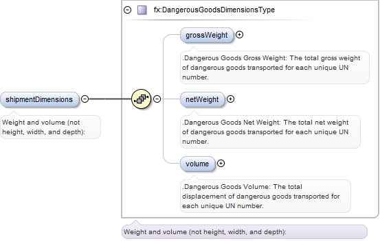
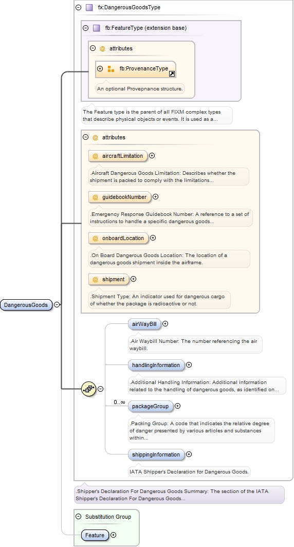
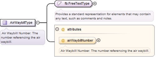
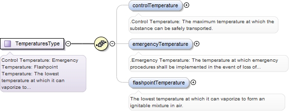
The Dangerous Goods schema contains the information required for the shipment of dangerous goods.
Copyright (c) 2014 Airservices Australia, EUROCONTROL, JCAB, NATS Limited, NavCanada, SESAR Joint Undertaking & US FAA =========================================== All rights reserved. Redistribution and use in source and binary forms, with or without modification, are permitted provided that the following conditions are met: * Redistributions of source code must retain the above copyright notice, this list of conditions and the disclaimer. * Redistributions in binary form must reproduce the above copyright notice, this list of conditions and the disclaimer in the documentation and/or other materials provided with the distribution. * Neither the names of Airservices Australia, EUROCONTROL, JCAB, NATS Limited, NavCanada, SESAR Joint Undertaking & US FAA nor the names of their contributors may be used to endorse or promote products derived from this specification without specific prior written permission. DISCLAIMER THIS SPECIFICATION IS PROVIDED BY THE COPYRIGHT HOLDERS AND CONTRIBUTORS "AS IS" AND ANY EXPRESS OR IMPLIED WARRANTIES, INCLUDING, BUT NOT LIMITED TO, THE IMPLIED WARRANTIES OF MERCHANTABILITY AND FITNESS FOR A PARTICULAR PURPOSE ARE DISCLAIMED. IN NO EVENT SHALL THE COPYRIGHT OWNER OR CONTRIBUTORS BE LIABLE FOR ANY DIRECT, INDIRECT, INCIDENTAL, SPECIAL, EXEMPLARY, OR CONSEQUENTIAL DAMAGES (INCLUDING, BUT NOT LIMITED TO, PROCUREMENT OF SUBSTITUTE GOODS OR SERVICES; LOSS OF USE, DATA, OR PROFITS; OR BUSINESS INTERRUPTION) HOWEVER CAUSED AND ON ANY THEORY OF LIABILITY, WHETHER IN CONTRACT, STRICT LIABILITY, OR TORT (INCLUDING NEGLIGENCE OR OTHERWISE) ARISING IN ANY WAY OUT OF THE USE OF THIS SOFTWARE, EVEN IF ADVISED OF THE POSSIBILITY OF SUCH DAMAGE. Editorial note: this license is an instance of the BSD license template as provided by the Open Source Initiative: http://www.opensource.org/licenses/bsd-license.php The authoritative reference for FIXM is www.FIXM.aero. Details on Airservices Australia: http://www.airservicesaustralia.com/ Details on EUROCONTROL: http://www.eurocontrol.int/ Details on JCAB: http://www.mlit.go.jp/en/koku/index.html Details on NATS Limited: http://www.nats.co.uk/ Details on NavCanada: http://www.navcanada.ca/ Details on the SESAR JU and its members: http://www.sesarju.eu/players/members Details on the US FAA: http://www.faa.gov/ Details on the US FAA’s NextGen program: http://www.faa.gov/NextGen
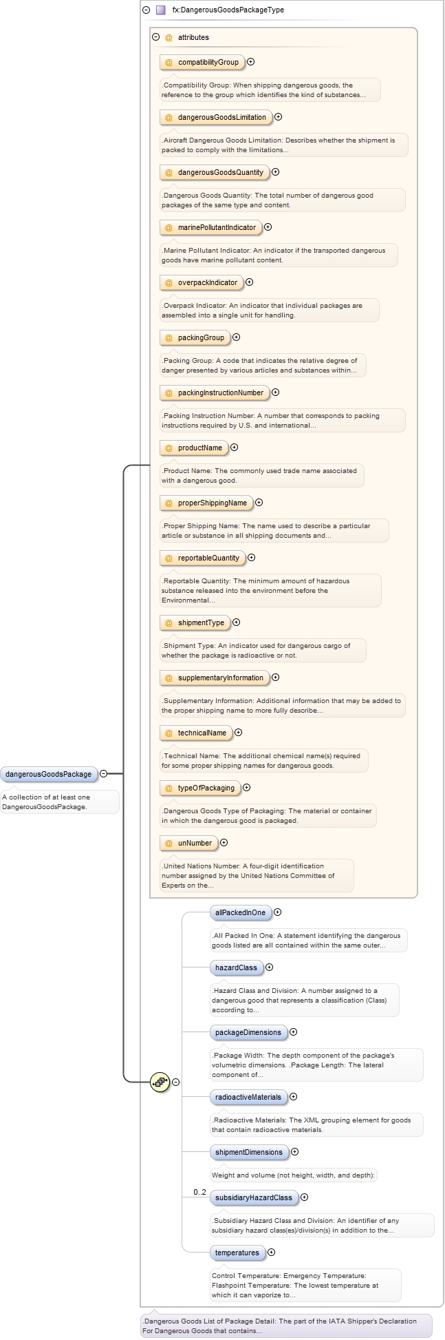
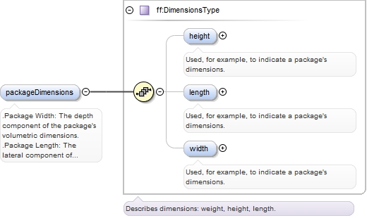
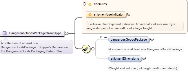
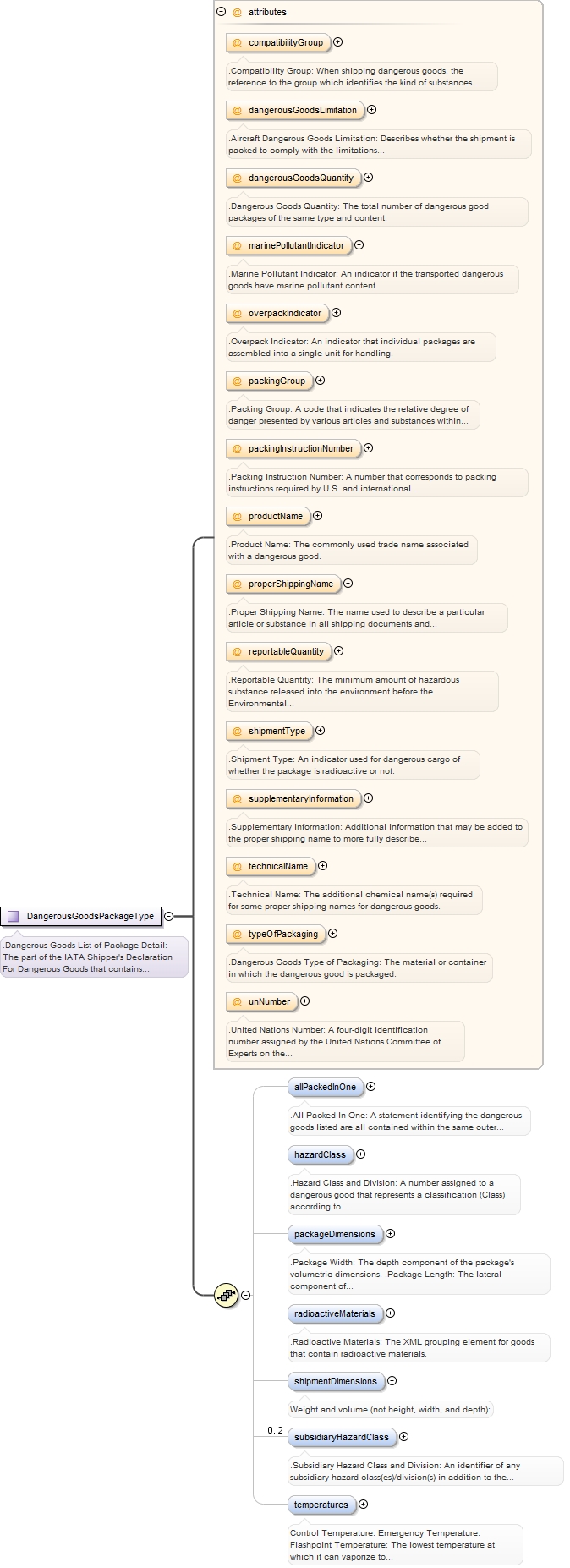
The FlightObject.Cargo.Packaging schema contains information about the packaging of dangerous goods.
Copyright (c) 2014 Airservices Australia, EUROCONTROL, JCAB, NATS Limited, NavCanada, SESAR Joint Undertaking & US FAA =========================================== All rights reserved. Redistribution and use in source and binary forms, with or without modification, are permitted provided that the following conditions are met: * Redistributions of source code must retain the above copyright notice, this list of conditions and the disclaimer. * Redistributions in binary form must reproduce the above copyright notice, this list of conditions and the disclaimer in the documentation and/or other materials provided with the distribution. * Neither the names of Airservices Australia, EUROCONTROL, JCAB, NATS Limited, NavCanada, SESAR Joint Undertaking & US FAA nor the names of their contributors may be used to endorse or promote products derived from this specification without specific prior written permission. DISCLAIMER THIS SPECIFICATION IS PROVIDED BY THE COPYRIGHT HOLDERS AND CONTRIBUTORS "AS IS" AND ANY EXPRESS OR IMPLIED WARRANTIES, INCLUDING, BUT NOT LIMITED TO, THE IMPLIED WARRANTIES OF MERCHANTABILITY AND FITNESS FOR A PARTICULAR PURPOSE ARE DISCLAIMED. IN NO EVENT SHALL THE COPYRIGHT OWNER OR CONTRIBUTORS BE LIABLE FOR ANY DIRECT, INDIRECT, INCIDENTAL, SPECIAL, EXEMPLARY, OR CONSEQUENTIAL DAMAGES (INCLUDING, BUT NOT LIMITED TO, PROCUREMENT OF SUBSTITUTE GOODS OR SERVICES; LOSS OF USE, DATA, OR PROFITS; OR BUSINESS INTERRUPTION) HOWEVER CAUSED AND ON ANY THEORY OF LIABILITY, WHETHER IN CONTRACT, STRICT LIABILITY, OR TORT (INCLUDING NEGLIGENCE OR OTHERWISE) ARISING IN ANY WAY OUT OF THE USE OF THIS SOFTWARE, EVEN IF ADVISED OF THE POSSIBILITY OF SUCH DAMAGE. Editorial note: this license is an instance of the BSD license template as provided by the Open Source Initiative: http://www.opensource.org/licenses/bsd-license.php The authoritative reference for FIXM is www.FIXM.aero. Details on Airservices Australia: http://www.airservicesaustralia.com/ Details on EUROCONTROL: http://www.eurocontrol.int/ Details on JCAB: http://www.mlit.go.jp/en/koku/index.html Details on NATS Limited: http://www.nats.co.uk/ Details on NavCanada: http://www.navcanada.ca/ Details on the SESAR JU and its members: http://www.sesarju.eu/players/members Details on the US FAA: http://www.faa.gov/ Details on the US FAA’s NextGen program: http://www.faa.gov/NextGen
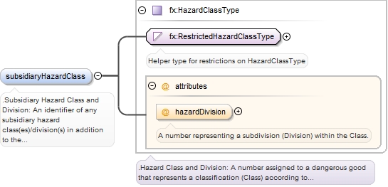
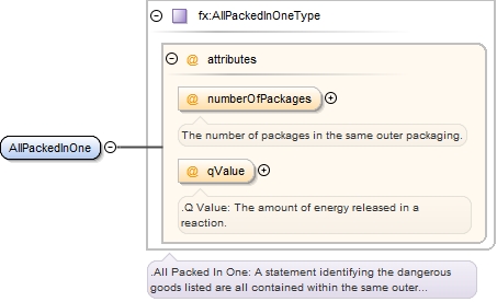
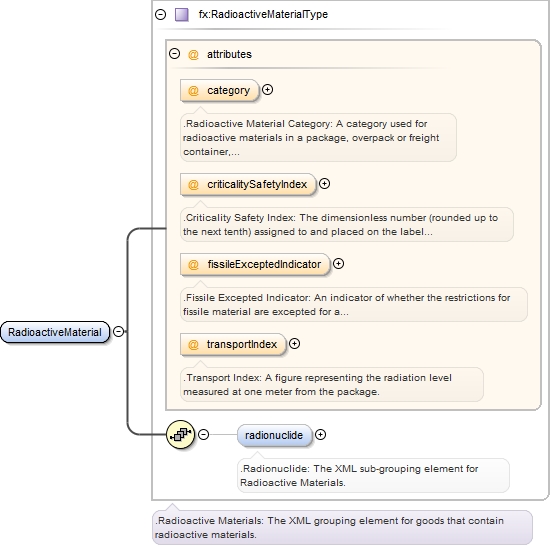
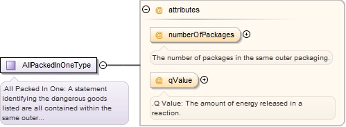
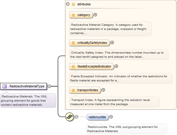
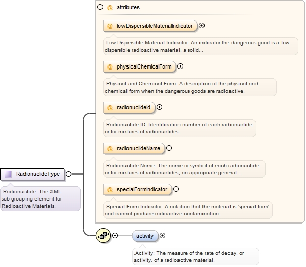
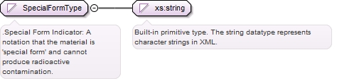
.Radioactive Materials: The XML grouping element for goods that contain radioactive materials.
Copyright (c) 2014 Airservices Australia, EUROCONTROL, JCAB, NATS Limited, NavCanada, SESAR Joint Undertaking & US FAA =========================================== All rights reserved. Redistribution and use in source and binary forms, with or without modification, are permitted provided that the following conditions are met: * Redistributions of source code must retain the above copyright notice, this list of conditions and the disclaimer. * Redistributions in binary form must reproduce the above copyright notice, this list of conditions and the disclaimer in the documentation and/or other materials provided with the distribution. * Neither the names of Airservices Australia, EUROCONTROL, JCAB, NATS Limited, NavCanada, SESAR Joint Undertaking & US FAA nor the names of their contributors may be used to endorse or promote products derived from this specification without specific prior written permission. DISCLAIMER THIS SPECIFICATION IS PROVIDED BY THE COPYRIGHT HOLDERS AND CONTRIBUTORS "AS IS" AND ANY EXPRESS OR IMPLIED WARRANTIES, INCLUDING, BUT NOT LIMITED TO, THE IMPLIED WARRANTIES OF MERCHANTABILITY AND FITNESS FOR A PARTICULAR PURPOSE ARE DISCLAIMED. IN NO EVENT SHALL THE COPYRIGHT OWNER OR CONTRIBUTORS BE LIABLE FOR ANY DIRECT, INDIRECT, INCIDENTAL, SPECIAL, EXEMPLARY, OR CONSEQUENTIAL DAMAGES (INCLUDING, BUT NOT LIMITED TO, PROCUREMENT OF SUBSTITUTE GOODS OR SERVICES; LOSS OF USE, DATA, OR PROFITS; OR BUSINESS INTERRUPTION) HOWEVER CAUSED AND ON ANY THEORY OF LIABILITY, WHETHER IN CONTRACT, STRICT LIABILITY, OR TORT (INCLUDING NEGLIGENCE OR OTHERWISE) ARISING IN ANY WAY OUT OF THE USE OF THIS SOFTWARE, EVEN IF ADVISED OF THE POSSIBILITY OF SUCH DAMAGE. Editorial note: this license is an instance of the BSD license template as provided by the Open Source Initiative: http://www.opensource.org/licenses/bsd-license.php The authoritative reference for FIXM is www.FIXM.aero. Details on Airservices Australia: http://www.airservicesaustralia.com/ Details on EUROCONTROL: http://www.eurocontrol.int/ Details on JCAB: http://www.mlit.go.jp/en/koku/index.html Details on NATS Limited: http://www.nats.co.uk/ Details on NavCanada: http://www.navcanada.ca/ Details on the SESAR JU and its members: http://www.sesarju.eu/players/members Details on the US FAA: http://www.faa.gov/ Details on the US FAA’s NextGen program: http://www.faa.gov/NextGen
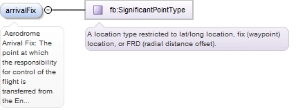
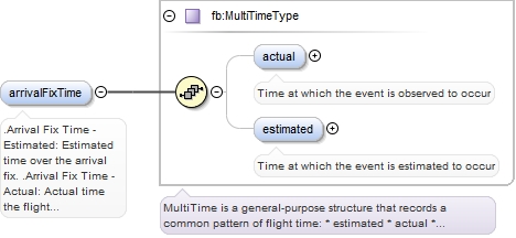
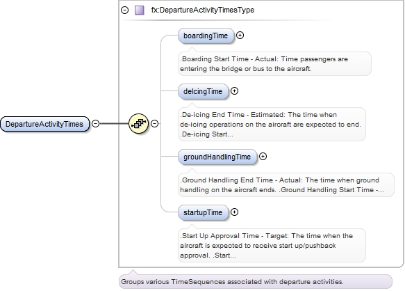
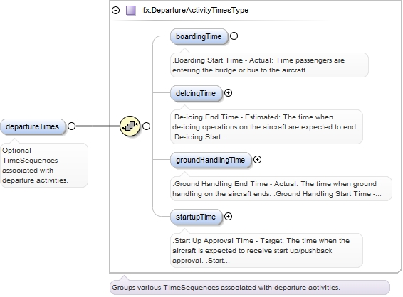
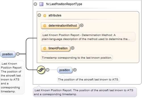
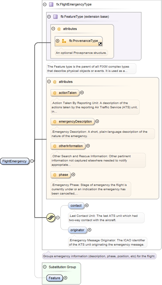
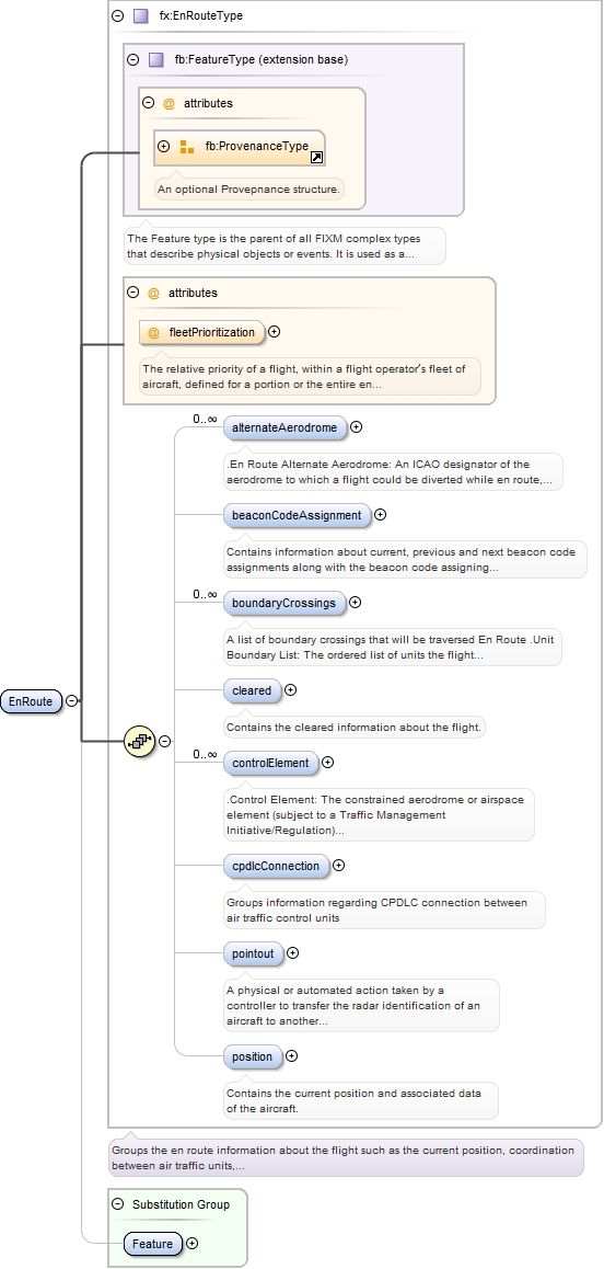
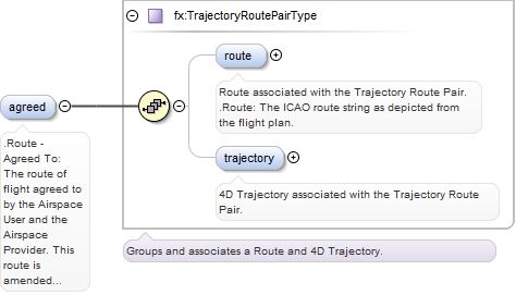
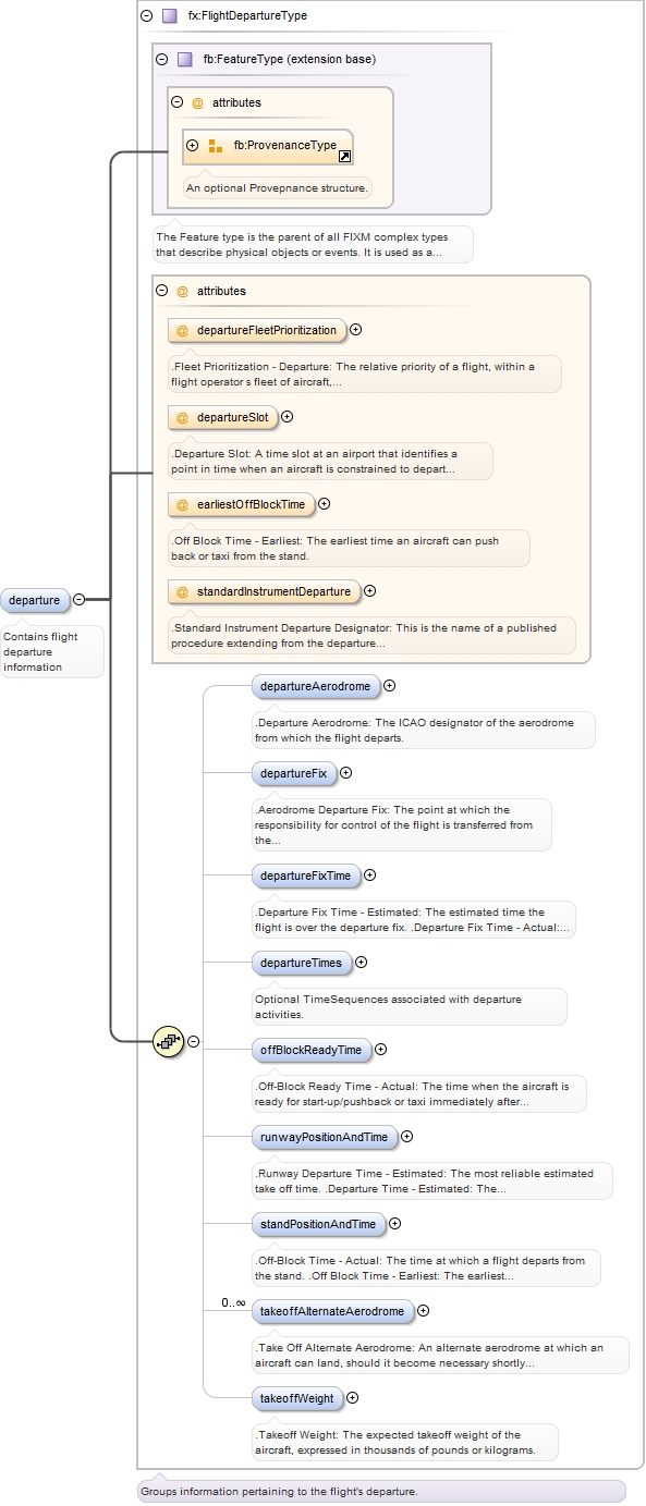
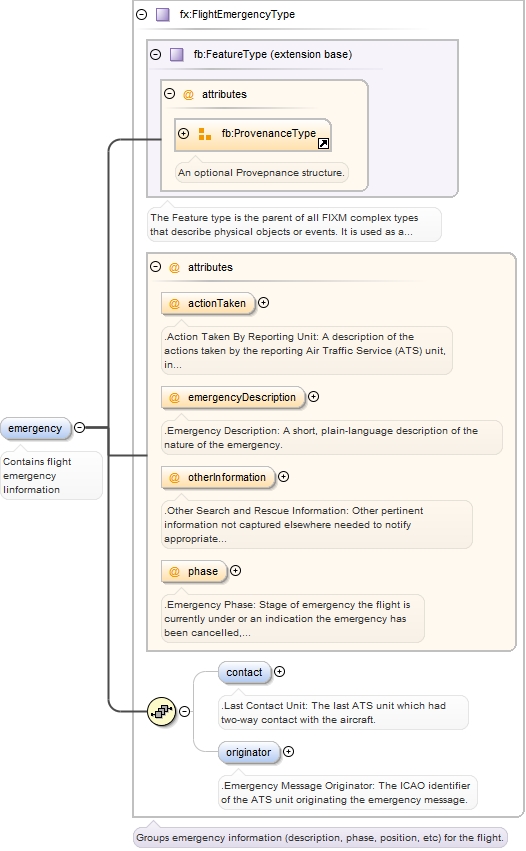
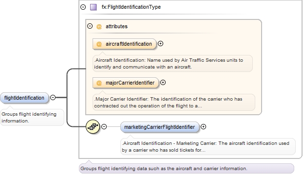
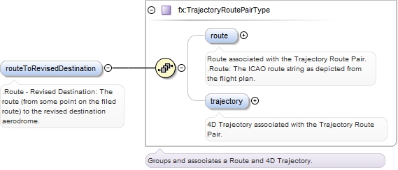
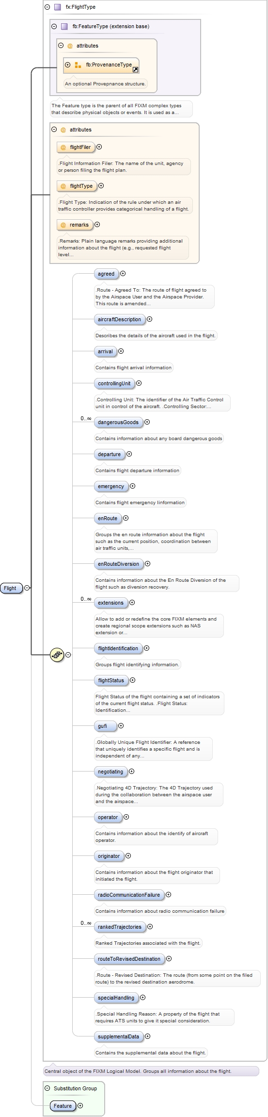
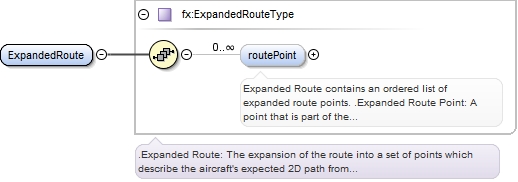
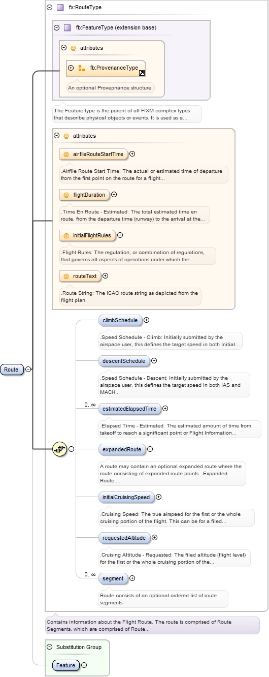
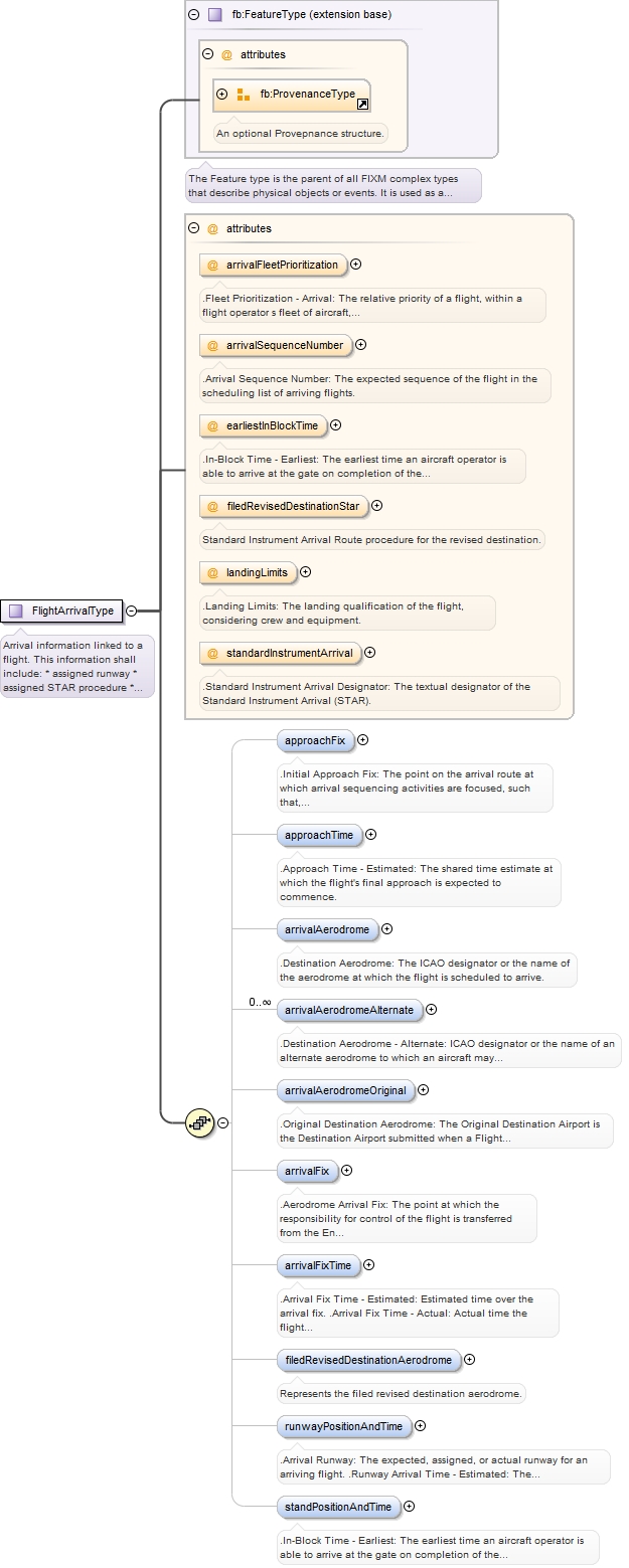
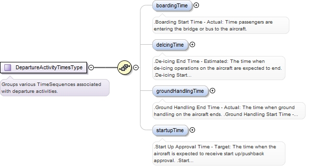
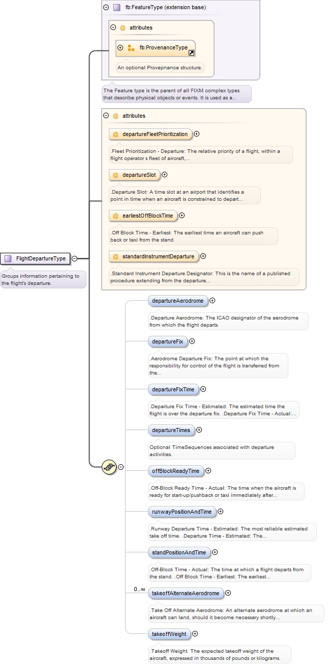
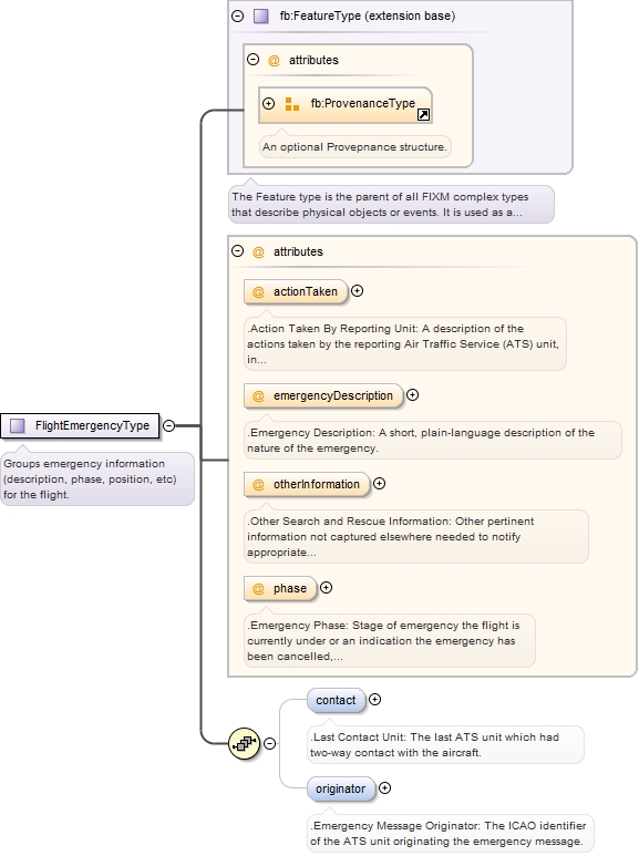
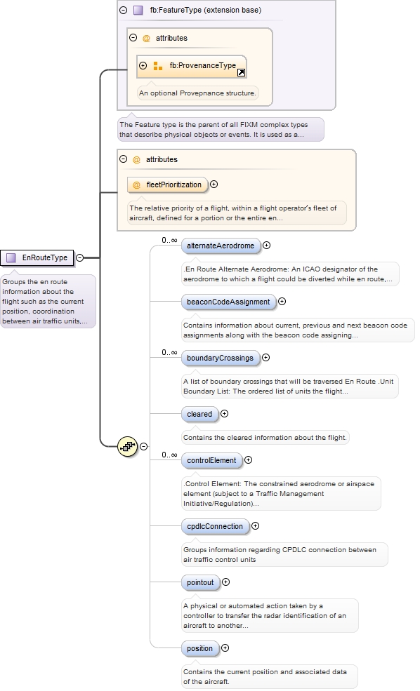
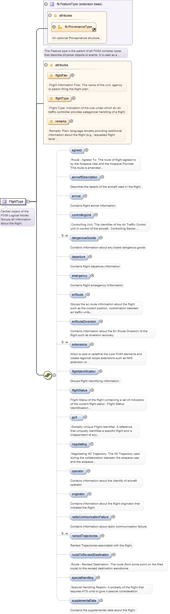
Flight is a central package of FIXM that groups information including departure, arrival, emergency, flight route, flight status and en route information.
Copyright (c) 2014 Airservices Australia, EUROCONTROL, JCAB, NATS Limited, NavCanada, SESAR Joint Undertaking & US FAA =========================================== All rights reserved. Redistribution and use in source and binary forms, with or without modification, are permitted provided that the following conditions are met: * Redistributions of source code must retain the above copyright notice, this list of conditions and the disclaimer. * Redistributions in binary form must reproduce the above copyright notice, this list of conditions and the disclaimer in the documentation and/or other materials provided with the distribution. * Neither the names of Airservices Australia, EUROCONTROL, JCAB, NATS Limited, NavCanada, SESAR Joint Undertaking & US FAA nor the names of their contributors may be used to endorse or promote products derived from this specification without specific prior written permission. DISCLAIMER THIS SPECIFICATION IS PROVIDED BY THE COPYRIGHT HOLDERS AND CONTRIBUTORS "AS IS" AND ANY EXPRESS OR IMPLIED WARRANTIES, INCLUDING, BUT NOT LIMITED TO, THE IMPLIED WARRANTIES OF MERCHANTABILITY AND FITNESS FOR A PARTICULAR PURPOSE ARE DISCLAIMED. IN NO EVENT SHALL THE COPYRIGHT OWNER OR CONTRIBUTORS BE LIABLE FOR ANY DIRECT, INDIRECT, INCIDENTAL, SPECIAL, EXEMPLARY, OR CONSEQUENTIAL DAMAGES (INCLUDING, BUT NOT LIMITED TO, PROCUREMENT OF SUBSTITUTE GOODS OR SERVICES; LOSS OF USE, DATA, OR PROFITS; OR BUSINESS INTERRUPTION) HOWEVER CAUSED AND ON ANY THEORY OF LIABILITY, WHETHER IN CONTRACT, STRICT LIABILITY, OR TORT (INCLUDING NEGLIGENCE OR OTHERWISE) ARISING IN ANY WAY OUT OF THE USE OF THIS SOFTWARE, EVEN IF ADVISED OF THE POSSIBILITY OF SUCH DAMAGE. Editorial note: this license is an instance of the BSD license template as provided by the Open Source Initiative: http://www.opensource.org/licenses/bsd-license.php The authoritative reference for FIXM is www.FIXM.aero. Details on Airservices Australia: http://www.airservicesaustralia.com/ Details on EUROCONTROL: http://www.eurocontrol.int/ Details on JCAB: http://www.mlit.go.jp/en/koku/index.html Details on NATS Limited: http://www.nats.co.uk/ Details on NavCanada: http://www.navcanada.ca/ Details on the SESAR JU and its members: http://www.sesarju.eu/players/members Details on the US FAA: http://www.faa.gov/ Details on the US FAA’s NextGen program: http://www.faa.gov/NextGen
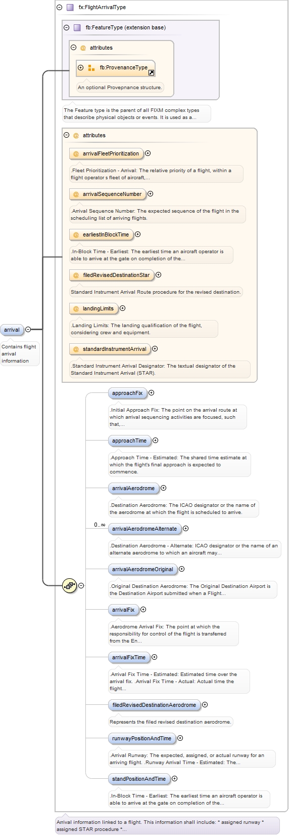
The Arrival package contains al information about the actual arrival of the flight at an airport, including approach, landing, and arrival at terminal.
Copyright (c) 2014 Airservices Australia, EUROCONTROL, JCAB, NATS Limited, NavCanada, SESAR Joint Undertaking & US FAA =========================================== All rights reserved. Redistribution and use in source and binary forms, with or without modification, are permitted provided that the following conditions are met: * Redistributions of source code must retain the above copyright notice, this list of conditions and the disclaimer. * Redistributions in binary form must reproduce the above copyright notice, this list of conditions and the disclaimer in the documentation and/or other materials provided with the distribution. * Neither the names of Airservices Australia, EUROCONTROL, JCAB, NATS Limited, NavCanada, SESAR Joint Undertaking & US FAA nor the names of their contributors may be used to endorse or promote products derived from this specification without specific prior written permission. DISCLAIMER THIS SPECIFICATION IS PROVIDED BY THE COPYRIGHT HOLDERS AND CONTRIBUTORS "AS IS" AND ANY EXPRESS OR IMPLIED WARRANTIES, INCLUDING, BUT NOT LIMITED TO, THE IMPLIED WARRANTIES OF MERCHANTABILITY AND FITNESS FOR A PARTICULAR PURPOSE ARE DISCLAIMED. IN NO EVENT SHALL THE COPYRIGHT OWNER OR CONTRIBUTORS BE LIABLE FOR ANY DIRECT, INDIRECT, INCIDENTAL, SPECIAL, EXEMPLARY, OR CONSEQUENTIAL DAMAGES (INCLUDING, BUT NOT LIMITED TO, PROCUREMENT OF SUBSTITUTE GOODS OR SERVICES; LOSS OF USE, DATA, OR PROFITS; OR BUSINESS INTERRUPTION) HOWEVER CAUSED AND ON ANY THEORY OF LIABILITY, WHETHER IN CONTRACT, STRICT LIABILITY, OR TORT (INCLUDING NEGLIGENCE OR OTHERWISE) ARISING IN ANY WAY OUT OF THE USE OF THIS SOFTWARE, EVEN IF ADVISED OF THE POSSIBILITY OF SUCH DAMAGE. Editorial note: this license is an instance of the BSD license template as provided by the Open Source Initiative: http://www.opensource.org/licenses/bsd-license.php The authoritative reference for FIXM is www.FIXM.aero. Details on Airservices Australia: http://www.airservicesaustralia.com/ Details on EUROCONTROL: http://www.eurocontrol.int/ Details on JCAB: http://www.mlit.go.jp/en/koku/index.html Details on NATS Limited: http://www.nats.co.uk/ Details on NavCanada: http://www.navcanada.ca/ Details on the SESAR JU and its members: http://www.sesarju.eu/players/members Details on the US FAA: http://www.faa.gov/ Details on the US FAA’s NextGen program: http://www.faa.gov/NextGen
The Arrival package contains al information about the actual departure of the flight at an airport.
Copyright (c) 2014 Airservices Australia, EUROCONTROL, JCAB, NATS Limited, NavCanada, SESAR Joint Undertaking & US FAA =========================================== All rights reserved. Redistribution and use in source and binary forms, with or without modification, are permitted provided that the following conditions are met: * Redistributions of source code must retain the above copyright notice, this list of conditions and the disclaimer. * Redistributions in binary form must reproduce the above copyright notice, this list of conditions and the disclaimer in the documentation and/or other materials provided with the distribution. * Neither the names of Airservices Australia, EUROCONTROL, JCAB, NATS Limited, NavCanada, SESAR Joint Undertaking & US FAA nor the names of their contributors may be used to endorse or promote products derived from this specification without specific prior written permission. DISCLAIMER THIS SPECIFICATION IS PROVIDED BY THE COPYRIGHT HOLDERS AND CONTRIBUTORS "AS IS" AND ANY EXPRESS OR IMPLIED WARRANTIES, INCLUDING, BUT NOT LIMITED TO, THE IMPLIED WARRANTIES OF MERCHANTABILITY AND FITNESS FOR A PARTICULAR PURPOSE ARE DISCLAIMED. IN NO EVENT SHALL THE COPYRIGHT OWNER OR CONTRIBUTORS BE LIABLE FOR ANY DIRECT, INDIRECT, INCIDENTAL, SPECIAL, EXEMPLARY, OR CONSEQUENTIAL DAMAGES (INCLUDING, BUT NOT LIMITED TO, PROCUREMENT OF SUBSTITUTE GOODS OR SERVICES; LOSS OF USE, DATA, OR PROFITS; OR BUSINESS INTERRUPTION) HOWEVER CAUSED AND ON ANY THEORY OF LIABILITY, WHETHER IN CONTRACT, STRICT LIABILITY, OR TORT (INCLUDING NEGLIGENCE OR OTHERWISE) ARISING IN ANY WAY OUT OF THE USE OF THIS SOFTWARE, EVEN IF ADVISED OF THE POSSIBILITY OF SUCH DAMAGE. Editorial note: this license is an instance of the BSD license template as provided by the Open Source Initiative: http://www.opensource.org/licenses/bsd-license.php The authoritative reference for FIXM is www.FIXM.aero. Details on Airservices Australia: http://www.airservicesaustralia.com/ Details on EUROCONTROL: http://www.eurocontrol.int/ Details on JCAB: http://www.mlit.go.jp/en/koku/index.html Details on NATS Limited: http://www.nats.co.uk/ Details on NavCanada: http://www.navcanada.ca/ Details on the SESAR JU and its members: http://www.sesarju.eu/players/members Details on the US FAA: http://www.faa.gov/ Details on the US FAA’s NextGen program: http://www.faa.gov/NextGen
The Emergency Package describes any emergency filed during the flight.
Copyright (c) 2014 Airservices Australia, EUROCONTROL, JCAB, NATS Limited, NavCanada, SESAR Joint Undertaking & US FAA =========================================== All rights reserved. Redistribution and use in source and binary forms, with or without modification, are permitted provided that the following conditions are met: * Redistributions of source code must retain the above copyright notice, this list of conditions and the disclaimer. * Redistributions in binary form must reproduce the above copyright notice, this list of conditions and the disclaimer in the documentation and/or other materials provided with the distribution. * Neither the names of Airservices Australia, EUROCONTROL, JCAB, NATS Limited, NavCanada, SESAR Joint Undertaking & US FAA nor the names of their contributors may be used to endorse or promote products derived from this specification without specific prior written permission. DISCLAIMER THIS SPECIFICATION IS PROVIDED BY THE COPYRIGHT HOLDERS AND CONTRIBUTORS "AS IS" AND ANY EXPRESS OR IMPLIED WARRANTIES, INCLUDING, BUT NOT LIMITED TO, THE IMPLIED WARRANTIES OF MERCHANTABILITY AND FITNESS FOR A PARTICULAR PURPOSE ARE DISCLAIMED. IN NO EVENT SHALL THE COPYRIGHT OWNER OR CONTRIBUTORS BE LIABLE FOR ANY DIRECT, INDIRECT, INCIDENTAL, SPECIAL, EXEMPLARY, OR CONSEQUENTIAL DAMAGES (INCLUDING, BUT NOT LIMITED TO, PROCUREMENT OF SUBSTITUTE GOODS OR SERVICES; LOSS OF USE, DATA, OR PROFITS; OR BUSINESS INTERRUPTION) HOWEVER CAUSED AND ON ANY THEORY OF LIABILITY, WHETHER IN CONTRACT, STRICT LIABILITY, OR TORT (INCLUDING NEGLIGENCE OR OTHERWISE) ARISING IN ANY WAY OUT OF THE USE OF THIS SOFTWARE, EVEN IF ADVISED OF THE POSSIBILITY OF SUCH DAMAGE. Editorial note: this license is an instance of the BSD license template as provided by the Open Source Initiative: http://www.opensource.org/licenses/bsd-license.php The authoritative reference for FIXM is www.FIXM.aero. Details on Airservices Australia: http://www.airservicesaustralia.com/ Details on EUROCONTROL: http://www.eurocontrol.int/ Details on JCAB: http://www.mlit.go.jp/en/koku/index.html Details on NATS Limited: http://www.nats.co.uk/ Details on NavCanada: http://www.navcanada.ca/ Details on the SESAR JU and its members: http://www.sesarju.eu/players/members Details on the US FAA: http://www.faa.gov/ Details on the US FAA’s NextGen program: http://www.faa.gov/NextGen
The EnRoute package consists of flight information while the flight is en route including the flight position and coordination between the air traffic control unit as the flight transitions between the unit boundaries along the route.
Copyright (c) 2014 Airservices Australia, EUROCONTROL, JCAB, NATS Limited, NavCanada, SESAR Joint Undertaking & US FAA =========================================== All rights reserved. Redistribution and use in source and binary forms, with or without modification, are permitted provided that the following conditions are met: * Redistributions of source code must retain the above copyright notice, this list of conditions and the disclaimer. * Redistributions in binary form must reproduce the above copyright notice, this list of conditions and the disclaimer in the documentation and/or other materials provided with the distribution. * Neither the names of Airservices Australia, EUROCONTROL, JCAB, NATS Limited, NavCanada, SESAR Joint Undertaking & US FAA nor the names of their contributors may be used to endorse or promote products derived from this specification without specific prior written permission. DISCLAIMER THIS SPECIFICATION IS PROVIDED BY THE COPYRIGHT HOLDERS AND CONTRIBUTORS "AS IS" AND ANY EXPRESS OR IMPLIED WARRANTIES, INCLUDING, BUT NOT LIMITED TO, THE IMPLIED WARRANTIES OF MERCHANTABILITY AND FITNESS FOR A PARTICULAR PURPOSE ARE DISCLAIMED. IN NO EVENT SHALL THE COPYRIGHT OWNER OR CONTRIBUTORS BE LIABLE FOR ANY DIRECT, INDIRECT, INCIDENTAL, SPECIAL, EXEMPLARY, OR CONSEQUENTIAL DAMAGES (INCLUDING, BUT NOT LIMITED TO, PROCUREMENT OF SUBSTITUTE GOODS OR SERVICES; LOSS OF USE, DATA, OR PROFITS; OR BUSINESS INTERRUPTION) HOWEVER CAUSED AND ON ANY THEORY OF LIABILITY, WHETHER IN CONTRACT, STRICT LIABILITY, OR TORT (INCLUDING NEGLIGENCE OR OTHERWISE) ARISING IN ANY WAY OUT OF THE USE OF THIS SOFTWARE, EVEN IF ADVISED OF THE POSSIBILITY OF SUCH DAMAGE. Editorial note: this license is an instance of the BSD license template as provided by the Open Source Initiative: http://www.opensource.org/licenses/bsd-license.php The authoritative reference for FIXM is www.FIXM.aero. Details on Airservices Australia: http://www.airservicesaustralia.com/ Details on EUROCONTROL: http://www.eurocontrol.int/ Details on JCAB: http://www.mlit.go.jp/en/koku/index.html Details on NATS Limited: http://www.nats.co.uk/ Details on NavCanada: http://www.navcanada.ca/ Details on the SESAR JU and its members: http://www.sesarju.eu/players/members Details on the US FAA: http://www.faa.gov/ Details on the US FAA’s NextGen program: http://www.faa.gov/NextGen
The Coordination package contains details of transfer of control between the air traffic control units as the flight progresses through the boundaries along the route.
Copyright (c) 2014 Airservices Australia, EUROCONTROL, JCAB, NATS Limited, NavCanada, SESAR Joint Undertaking & US FAA =========================================== All rights reserved. Redistribution and use in source and binary forms, with or without modification, are permitted provided that the following conditions are met: * Redistributions of source code must retain the above copyright notice, this list of conditions and the disclaimer. * Redistributions in binary form must reproduce the above copyright notice, this list of conditions and the disclaimer in the documentation and/or other materials provided with the distribution. * Neither the names of Airservices Australia, EUROCONTROL, JCAB, NATS Limited, NavCanada, SESAR Joint Undertaking & US FAA nor the names of their contributors may be used to endorse or promote products derived from this specification without specific prior written permission. DISCLAIMER THIS SPECIFICATION IS PROVIDED BY THE COPYRIGHT HOLDERS AND CONTRIBUTORS "AS IS" AND ANY EXPRESS OR IMPLIED WARRANTIES, INCLUDING, BUT NOT LIMITED TO, THE IMPLIED WARRANTIES OF MERCHANTABILITY AND FITNESS FOR A PARTICULAR PURPOSE ARE DISCLAIMED. IN NO EVENT SHALL THE COPYRIGHT OWNER OR CONTRIBUTORS BE LIABLE FOR ANY DIRECT, INDIRECT, INCIDENTAL, SPECIAL, EXEMPLARY, OR CONSEQUENTIAL DAMAGES (INCLUDING, BUT NOT LIMITED TO, PROCUREMENT OF SUBSTITUTE GOODS OR SERVICES; LOSS OF USE, DATA, OR PROFITS; OR BUSINESS INTERRUPTION) HOWEVER CAUSED AND ON ANY THEORY OF LIABILITY, WHETHER IN CONTRACT, STRICT LIABILITY, OR TORT (INCLUDING NEGLIGENCE OR OTHERWISE) ARISING IN ANY WAY OUT OF THE USE OF THIS SOFTWARE, EVEN IF ADVISED OF THE POSSIBILITY OF SUCH DAMAGE. Editorial note: this license is an instance of the BSD license template as provided by the Open Source Initiative: http://www.opensource.org/licenses/bsd-license.php The authoritative reference for FIXM is www.FIXM.aero. Details on Airservices Australia: http://www.airservicesaustralia.com/ Details on EUROCONTROL: http://www.eurocontrol.int/ Details on JCAB: http://www.mlit.go.jp/en/koku/index.html Details on NATS Limited: http://www.nats.co.uk/ Details on NavCanada: http://www.navcanada.ca/ Details on the SESAR JU and its members: http://www.sesarju.eu/players/members Details on the US FAA: http://www.faa.gov/ Details on the US FAA’s NextGen program: http://www.faa.gov/NextGen
Contains coordination status details during the coordination between the air traffic control units.
Copyright (c) 2014 Airservices Australia, EUROCONTROL, JCAB, NATS Limited, NavCanada, SESAR Joint Undertaking & US FAA =========================================== All rights reserved. Redistribution and use in source and binary forms, with or without modification, are permitted provided that the following conditions are met: * Redistributions of source code must retain the above copyright notice, this list of conditions and the disclaimer. * Redistributions in binary form must reproduce the above copyright notice, this list of conditions and the disclaimer in the documentation and/or other materials provided with the distribution. * Neither the names of Airservices Australia, EUROCONTROL, JCAB, NATS Limited, NavCanada, SESAR Joint Undertaking & US FAA nor the names of their contributors may be used to endorse or promote products derived from this specification without specific prior written permission. DISCLAIMER THIS SPECIFICATION IS PROVIDED BY THE COPYRIGHT HOLDERS AND CONTRIBUTORS "AS IS" AND ANY EXPRESS OR IMPLIED WARRANTIES, INCLUDING, BUT NOT LIMITED TO, THE IMPLIED WARRANTIES OF MERCHANTABILITY AND FITNESS FOR A PARTICULAR PURPOSE ARE DISCLAIMED. IN NO EVENT SHALL THE COPYRIGHT OWNER OR CONTRIBUTORS BE LIABLE FOR ANY DIRECT, INDIRECT, INCIDENTAL, SPECIAL, EXEMPLARY, OR CONSEQUENTIAL DAMAGES (INCLUDING, BUT NOT LIMITED TO, PROCUREMENT OF SUBSTITUTE GOODS OR SERVICES; LOSS OF USE, DATA, OR PROFITS; OR BUSINESS INTERRUPTION) HOWEVER CAUSED AND ON ANY THEORY OF LIABILITY, WHETHER IN CONTRACT, STRICT LIABILITY, OR TORT (INCLUDING NEGLIGENCE OR OTHERWISE) ARISING IN ANY WAY OUT OF THE USE OF THIS SOFTWARE, EVEN IF ADVISED OF THE POSSIBILITY OF SUCH DAMAGE. Editorial note: this license is an instance of the BSD license template as provided by the Open Source Initiative: http://www.opensource.org/licenses/bsd-license.php The authoritative reference for FIXM is www.FIXM.aero. Details on Airservices Australia: http://www.airservicesaustralia.com/ Details on EUROCONTROL: http://www.eurocontrol.int/ Details on JCAB: http://www.mlit.go.jp/en/koku/index.html Details on NATS Limited: http://www.nats.co.uk/ Details on NavCanada: http://www.navcanada.ca/ Details on the SESAR JU and its members: http://www.sesarju.eu/players/members Details on the US FAA: http://www.faa.gov/ Details on the US FAA’s NextGen program: http://www.faa.gov/NextGen
Describes the CPDLC connection between Air Traffic Control Units
Copyright (c) 2014 Airservices Australia, EUROCONTROL, JCAB, NATS Limited, NavCanada, SESAR Joint Undertaking & US FAA =========================================== All rights reserved. Redistribution and use in source and binary forms, with or without modification, are permitted provided that the following conditions are met: * Redistributions of source code must retain the above copyright notice, this list of conditions and the disclaimer. * Redistributions in binary form must reproduce the above copyright notice, this list of conditions and the disclaimer in the documentation and/or other materials provided with the distribution. * Neither the names of Airservices Australia, EUROCONTROL, JCAB, NATS Limited, NavCanada, SESAR Joint Undertaking & US FAA nor the names of their contributors may be used to endorse or promote products derived from this specification without specific prior written permission. DISCLAIMER THIS SPECIFICATION IS PROVIDED BY THE COPYRIGHT HOLDERS AND CONTRIBUTORS "AS IS" AND ANY EXPRESS OR IMPLIED WARRANTIES, INCLUDING, BUT NOT LIMITED TO, THE IMPLIED WARRANTIES OF MERCHANTABILITY AND FITNESS FOR A PARTICULAR PURPOSE ARE DISCLAIMED. IN NO EVENT SHALL THE COPYRIGHT OWNER OR CONTRIBUTORS BE LIABLE FOR ANY DIRECT, INDIRECT, INCIDENTAL, SPECIAL, EXEMPLARY, OR CONSEQUENTIAL DAMAGES (INCLUDING, BUT NOT LIMITED TO, PROCUREMENT OF SUBSTITUTE GOODS OR SERVICES; LOSS OF USE, DATA, OR PROFITS; OR BUSINESS INTERRUPTION) HOWEVER CAUSED AND ON ANY THEORY OF LIABILITY, WHETHER IN CONTRACT, STRICT LIABILITY, OR TORT (INCLUDING NEGLIGENCE OR OTHERWISE) ARISING IN ANY WAY OUT OF THE USE OF THIS SOFTWARE, EVEN IF ADVISED OF THE POSSIBILITY OF SUCH DAMAGE. Editorial note: this license is an instance of the BSD license template as provided by the Open Source Initiative: http://www.opensource.org/licenses/bsd-license.php The authoritative reference for FIXM is www.FIXM.aero. Details on Airservices Australia: http://www.airservicesaustralia.com/ Details on EUROCONTROL: http://www.eurocontrol.int/ Details on JCAB: http://www.mlit.go.jp/en/koku/index.html Details on NATS Limited: http://www.nats.co.uk/ Details on NavCanada: http://www.navcanada.ca/ Details on the SESAR JU and its members: http://www.sesarju.eu/players/members Details on the US FAA: http://www.faa.gov/ Details on the US FAA’s NextGen program: http://www.faa.gov/NextGen
The EnRouteData package contains the high level en route and status information throughout the flight.
Copyright (c) 2014 Airservices Australia, EUROCONTROL, JCAB, NATS Limited, NavCanada, SESAR Joint Undertaking & US FAA =========================================== All rights reserved. Redistribution and use in source and binary forms, with or without modification, are permitted provided that the following conditions are met: * Redistributions of source code must retain the above copyright notice, this list of conditions and the disclaimer. * Redistributions in binary form must reproduce the above copyright notice, this list of conditions and the disclaimer in the documentation and/or other materials provided with the distribution. * Neither the names of Airservices Australia, EUROCONTROL, JCAB, NATS Limited, NavCanada, SESAR Joint Undertaking & US FAA nor the names of their contributors may be used to endorse or promote products derived from this specification without specific prior written permission. DISCLAIMER THIS SPECIFICATION IS PROVIDED BY THE COPYRIGHT HOLDERS AND CONTRIBUTORS "AS IS" AND ANY EXPRESS OR IMPLIED WARRANTIES, INCLUDING, BUT NOT LIMITED TO, THE IMPLIED WARRANTIES OF MERCHANTABILITY AND FITNESS FOR A PARTICULAR PURPOSE ARE DISCLAIMED. IN NO EVENT SHALL THE COPYRIGHT OWNER OR CONTRIBUTORS BE LIABLE FOR ANY DIRECT, INDIRECT, INCIDENTAL, SPECIAL, EXEMPLARY, OR CONSEQUENTIAL DAMAGES (INCLUDING, BUT NOT LIMITED TO, PROCUREMENT OF SUBSTITUTE GOODS OR SERVICES; LOSS OF USE, DATA, OR PROFITS; OR BUSINESS INTERRUPTION) HOWEVER CAUSED AND ON ANY THEORY OF LIABILITY, WHETHER IN CONTRACT, STRICT LIABILITY, OR TORT (INCLUDING NEGLIGENCE OR OTHERWISE) ARISING IN ANY WAY OUT OF THE USE OF THIS SOFTWARE, EVEN IF ADVISED OF THE POSSIBILITY OF SUCH DAMAGE. Editorial note: this license is an instance of the BSD license template as provided by the Open Source Initiative: http://www.opensource.org/licenses/bsd-license.php The authoritative reference for FIXM is www.FIXM.aero. Details on Airservices Australia: http://www.airservicesaustralia.com/ Details on EUROCONTROL: http://www.eurocontrol.int/ Details on JCAB: http://www.mlit.go.jp/en/koku/index.html Details on NATS Limited: http://www.nats.co.uk/ Details on NavCanada: http://www.navcanada.ca/ Details on the SESAR JU and its members: http://www.sesarju.eu/players/members Details on the US FAA: http://www.faa.gov/ Details on the US FAA’s NextGen program: http://www.faa.gov/NextGen
The Position package contains information about the flight's current and planned reporting positions.
Copyright (c) 2014 Airservices Australia, EUROCONTROL, JCAB, NATS Limited, NavCanada, SESAR Joint Undertaking & US FAA =========================================== All rights reserved. Redistribution and use in source and binary forms, with or without modification, are permitted provided that the following conditions are met: * Redistributions of source code must retain the above copyright notice, this list of conditions and the disclaimer. * Redistributions in binary form must reproduce the above copyright notice, this list of conditions and the disclaimer in the documentation and/or other materials provided with the distribution. * Neither the names of Airservices Australia, EUROCONTROL, JCAB, NATS Limited, NavCanada, SESAR Joint Undertaking & US FAA nor the names of their contributors may be used to endorse or promote products derived from this specification without specific prior written permission. DISCLAIMER THIS SPECIFICATION IS PROVIDED BY THE COPYRIGHT HOLDERS AND CONTRIBUTORS "AS IS" AND ANY EXPRESS OR IMPLIED WARRANTIES, INCLUDING, BUT NOT LIMITED TO, THE IMPLIED WARRANTIES OF MERCHANTABILITY AND FITNESS FOR A PARTICULAR PURPOSE ARE DISCLAIMED. IN NO EVENT SHALL THE COPYRIGHT OWNER OR CONTRIBUTORS BE LIABLE FOR ANY DIRECT, INDIRECT, INCIDENTAL, SPECIAL, EXEMPLARY, OR CONSEQUENTIAL DAMAGES (INCLUDING, BUT NOT LIMITED TO, PROCUREMENT OF SUBSTITUTE GOODS OR SERVICES; LOSS OF USE, DATA, OR PROFITS; OR BUSINESS INTERRUPTION) HOWEVER CAUSED AND ON ANY THEORY OF LIABILITY, WHETHER IN CONTRACT, STRICT LIABILITY, OR TORT (INCLUDING NEGLIGENCE OR OTHERWISE) ARISING IN ANY WAY OUT OF THE USE OF THIS SOFTWARE, EVEN IF ADVISED OF THE POSSIBILITY OF SUCH DAMAGE. Editorial note: this license is an instance of the BSD license template as provided by the Open Source Initiative: http://www.opensource.org/licenses/bsd-license.php The authoritative reference for FIXM is www.FIXM.aero. Details on Airservices Australia: http://www.airservicesaustralia.com/ Details on EUROCONTROL: http://www.eurocontrol.int/ Details on JCAB: http://www.mlit.go.jp/en/koku/index.html Details on NATS Limited: http://www.nats.co.uk/ Details on NavCanada: http://www.navcanada.ca/ Details on the SESAR JU and its members: http://www.sesarju.eu/players/members Details on the US FAA: http://www.faa.gov/ Details on the US FAA’s NextGen program: http://www.faa.gov/NextGen
The flight data package contains information describing all details associated with the flight. It is a central package of the FIXM logical model.
Copyright (c) 2014 Airservices Australia, EUROCONTROL, JCAB, NATS Limited, NavCanada, SESAR Joint Undertaking & US FAA =========================================== All rights reserved. Redistribution and use in source and binary forms, with or without modification, are permitted provided that the following conditions are met: * Redistributions of source code must retain the above copyright notice, this list of conditions and the disclaimer. * Redistributions in binary form must reproduce the above copyright notice, this list of conditions and the disclaimer in the documentation and/or other materials provided with the distribution. * Neither the names of Airservices Australia, EUROCONTROL, JCAB, NATS Limited, NavCanada, SESAR Joint Undertaking & US FAA nor the names of their contributors may be used to endorse or promote products derived from this specification without specific prior written permission. DISCLAIMER THIS SPECIFICATION IS PROVIDED BY THE COPYRIGHT HOLDERS AND CONTRIBUTORS "AS IS" AND ANY EXPRESS OR IMPLIED WARRANTIES, INCLUDING, BUT NOT LIMITED TO, THE IMPLIED WARRANTIES OF MERCHANTABILITY AND FITNESS FOR A PARTICULAR PURPOSE ARE DISCLAIMED. IN NO EVENT SHALL THE COPYRIGHT OWNER OR CONTRIBUTORS BE LIABLE FOR ANY DIRECT, INDIRECT, INCIDENTAL, SPECIAL, EXEMPLARY, OR CONSEQUENTIAL DAMAGES (INCLUDING, BUT NOT LIMITED TO, PROCUREMENT OF SUBSTITUTE GOODS OR SERVICES; LOSS OF USE, DATA, OR PROFITS; OR BUSINESS INTERRUPTION) HOWEVER CAUSED AND ON ANY THEORY OF LIABILITY, WHETHER IN CONTRACT, STRICT LIABILITY, OR TORT (INCLUDING NEGLIGENCE OR OTHERWISE) ARISING IN ANY WAY OUT OF THE USE OF THIS SOFTWARE, EVEN IF ADVISED OF THE POSSIBILITY OF SUCH DAMAGE. Editorial note: this license is an instance of the BSD license template as provided by the Open Source Initiative: http://www.opensource.org/licenses/bsd-license.php The authoritative reference for FIXM is www.FIXM.aero. Details on Airservices Australia: http://www.airservicesaustralia.com/ Details on EUROCONTROL: http://www.eurocontrol.int/ Details on JCAB: http://www.mlit.go.jp/en/koku/index.html Details on NATS Limited: http://www.nats.co.uk/ Details on NavCanada: http://www.navcanada.ca/ Details on the SESAR JU and its members: http://www.sesarju.eu/players/members Details on the US FAA: http://www.faa.gov/ Details on the US FAA’s NextGen program: http://www.faa.gov/NextGen
This package defines the ranked trajectory information.
Copyright (c) 2014 Airservices Australia, EUROCONTROL, JCAB, NATS Limited, NavCanada, SESAR Joint Undertaking & US FAA =========================================== All rights reserved. Redistribution and use in source and binary forms, with or without modification, are permitted provided that the following conditions are met: * Redistributions of source code must retain the above copyright notice, this list of conditions and the disclaimer. * Redistributions in binary form must reproduce the above copyright notice, this list of conditions and the disclaimer in the documentation and/or other materials provided with the distribution. * Neither the names of Airservices Australia, EUROCONTROL, JCAB, NATS Limited, NavCanada, SESAR Joint Undertaking & US FAA nor the names of their contributors may be used to endorse or promote products derived from this specification without specific prior written permission. DISCLAIMER THIS SPECIFICATION IS PROVIDED BY THE COPYRIGHT HOLDERS AND CONTRIBUTORS "AS IS" AND ANY EXPRESS OR IMPLIED WARRANTIES, INCLUDING, BUT NOT LIMITED TO, THE IMPLIED WARRANTIES OF MERCHANTABILITY AND FITNESS FOR A PARTICULAR PURPOSE ARE DISCLAIMED. IN NO EVENT SHALL THE COPYRIGHT OWNER OR CONTRIBUTORS BE LIABLE FOR ANY DIRECT, INDIRECT, INCIDENTAL, SPECIAL, EXEMPLARY, OR CONSEQUENTIAL DAMAGES (INCLUDING, BUT NOT LIMITED TO, PROCUREMENT OF SUBSTITUTE GOODS OR SERVICES; LOSS OF USE, DATA, OR PROFITS; OR BUSINESS INTERRUPTION) HOWEVER CAUSED AND ON ANY THEORY OF LIABILITY, WHETHER IN CONTRACT, STRICT LIABILITY, OR TORT (INCLUDING NEGLIGENCE OR OTHERWISE) ARISING IN ANY WAY OUT OF THE USE OF THIS SOFTWARE, EVEN IF ADVISED OF THE POSSIBILITY OF SUCH DAMAGE. Editorial note: this license is an instance of the BSD license template as provided by the Open Source Initiative: http://www.opensource.org/licenses/bsd-license.php The authoritative reference for FIXM is www.FIXM.aero. Details on Airservices Australia: http://www.airservicesaustralia.com/ Details on EUROCONTROL: http://www.eurocontrol.int/ Details on JCAB: http://www.mlit.go.jp/en/koku/index.html Details on NATS Limited: http://www.nats.co.uk/ Details on NavCanada: http://www.navcanada.ca/ Details on the SESAR JU and its members: http://www.sesarju.eu/players/members Details on the US FAA: http://www.faa.gov/ Details on the US FAA’s NextGen program: http://www.faa.gov/NextGen
Trajectory package contains the 4D Trajectory information.
Copyright (c) 2014 Airservices Australia, EUROCONTROL, JCAB, NATS Limited, NavCanada, SESAR Joint Undertaking & US FAA =========================================== All rights reserved. Redistribution and use in source and binary forms, with or without modification, are permitted provided that the following conditions are met: * Redistributions of source code must retain the above copyright notice, this list of conditions and the disclaimer. * Redistributions in binary form must reproduce the above copyright notice, this list of conditions and the disclaimer in the documentation and/or other materials provided with the distribution. * Neither the names of Airservices Australia, EUROCONTROL, JCAB, NATS Limited, NavCanada, SESAR Joint Undertaking & US FAA nor the names of their contributors may be used to endorse or promote products derived from this specification without specific prior written permission. DISCLAIMER THIS SPECIFICATION IS PROVIDED BY THE COPYRIGHT HOLDERS AND CONTRIBUTORS "AS IS" AND ANY EXPRESS OR IMPLIED WARRANTIES, INCLUDING, BUT NOT LIMITED TO, THE IMPLIED WARRANTIES OF MERCHANTABILITY AND FITNESS FOR A PARTICULAR PURPOSE ARE DISCLAIMED. IN NO EVENT SHALL THE COPYRIGHT OWNER OR CONTRIBUTORS BE LIABLE FOR ANY DIRECT, INDIRECT, INCIDENTAL, SPECIAL, EXEMPLARY, OR CONSEQUENTIAL DAMAGES (INCLUDING, BUT NOT LIMITED TO, PROCUREMENT OF SUBSTITUTE GOODS OR SERVICES; LOSS OF USE, DATA, OR PROFITS; OR BUSINESS INTERRUPTION) HOWEVER CAUSED AND ON ANY THEORY OF LIABILITY, WHETHER IN CONTRACT, STRICT LIABILITY, OR TORT (INCLUDING NEGLIGENCE OR OTHERWISE) ARISING IN ANY WAY OUT OF THE USE OF THIS SOFTWARE, EVEN IF ADVISED OF THE POSSIBILITY OF SUCH DAMAGE. Editorial note: this license is an instance of the BSD license template as provided by the Open Source Initiative: http://www.opensource.org/licenses/bsd-license.php The authoritative reference for FIXM is www.FIXM.aero. Details on Airservices Australia: http://www.airservicesaustralia.com/ Details on EUROCONTROL: http://www.eurocontrol.int/ Details on JCAB: http://www.mlit.go.jp/en/koku/index.html Details on NATS Limited: http://www.nats.co.uk/ Details on NavCanada: http://www.navcanada.ca/ Details on the SESAR JU and its members: http://www.sesarju.eu/players/members Details on the US FAA: http://www.faa.gov/ Details on the US FAA’s NextGen program: http://www.faa.gov/NextGen
Route package contains details about the flight route.
Copyright (c) 2014 Airservices Australia, EUROCONTROL, JCAB, NATS Limited, NavCanada, SESAR Joint Undertaking & US FAA =========================================== All rights reserved. Redistribution and use in source and binary forms, with or without modification, are permitted provided that the following conditions are met: * Redistributions of source code must retain the above copyright notice, this list of conditions and the disclaimer. * Redistributions in binary form must reproduce the above copyright notice, this list of conditions and the disclaimer in the documentation and/or other materials provided with the distribution. * Neither the names of Airservices Australia, EUROCONTROL, JCAB, NATS Limited, NavCanada, SESAR Joint Undertaking & US FAA nor the names of their contributors may be used to endorse or promote products derived from this specification without specific prior written permission. DISCLAIMER THIS SPECIFICATION IS PROVIDED BY THE COPYRIGHT HOLDERS AND CONTRIBUTORS "AS IS" AND ANY EXPRESS OR IMPLIED WARRANTIES, INCLUDING, BUT NOT LIMITED TO, THE IMPLIED WARRANTIES OF MERCHANTABILITY AND FITNESS FOR A PARTICULAR PURPOSE ARE DISCLAIMED. IN NO EVENT SHALL THE COPYRIGHT OWNER OR CONTRIBUTORS BE LIABLE FOR ANY DIRECT, INDIRECT, INCIDENTAL, SPECIAL, EXEMPLARY, OR CONSEQUENTIAL DAMAGES (INCLUDING, BUT NOT LIMITED TO, PROCUREMENT OF SUBSTITUTE GOODS OR SERVICES; LOSS OF USE, DATA, OR PROFITS; OR BUSINESS INTERRUPTION) HOWEVER CAUSED AND ON ANY THEORY OF LIABILITY, WHETHER IN CONTRACT, STRICT LIABILITY, OR TORT (INCLUDING NEGLIGENCE OR OTHERWISE) ARISING IN ANY WAY OUT OF THE USE OF THIS SOFTWARE, EVEN IF ADVISED OF THE POSSIBILITY OF SUCH DAMAGE. Editorial note: this license is an instance of the BSD license template as provided by the Open Source Initiative: http://www.opensource.org/licenses/bsd-license.php The authoritative reference for FIXM is www.FIXM.aero. Details on Airservices Australia: http://www.airservicesaustralia.com/ Details on EUROCONTROL: http://www.eurocontrol.int/ Details on JCAB: http://www.mlit.go.jp/en/koku/index.html Details on NATS Limited: http://www.nats.co.uk/ Details on NavCanada: http://www.navcanada.ca/ Details on the SESAR JU and its members: http://www.sesarju.eu/players/members Details on the US FAA: http://www.faa.gov/ Details on the US FAA’s NextGen program: http://www.faa.gov/NextGen
Constraints package contains details about any constraints that are associated with the route points.
Copyright (c) 2014 Airservices Australia, EUROCONTROL, JCAB, NATS Limited, NavCanada, SESAR Joint Undertaking & US FAA =========================================== All rights reserved. Redistribution and use in source and binary forms, with or without modification, are permitted provided that the following conditions are met: * Redistributions of source code must retain the above copyright notice, this list of conditions and the disclaimer. * Redistributions in binary form must reproduce the above copyright notice, this list of conditions and the disclaimer in the documentation and/or other materials provided with the distribution. * Neither the names of Airservices Australia, EUROCONTROL, JCAB, NATS Limited, NavCanada, SESAR Joint Undertaking & US FAA nor the names of their contributors may be used to endorse or promote products derived from this specification without specific prior written permission. DISCLAIMER THIS SPECIFICATION IS PROVIDED BY THE COPYRIGHT HOLDERS AND CONTRIBUTORS "AS IS" AND ANY EXPRESS OR IMPLIED WARRANTIES, INCLUDING, BUT NOT LIMITED TO, THE IMPLIED WARRANTIES OF MERCHANTABILITY AND FITNESS FOR A PARTICULAR PURPOSE ARE DISCLAIMED. IN NO EVENT SHALL THE COPYRIGHT OWNER OR CONTRIBUTORS BE LIABLE FOR ANY DIRECT, INDIRECT, INCIDENTAL, SPECIAL, EXEMPLARY, OR CONSEQUENTIAL DAMAGES (INCLUDING, BUT NOT LIMITED TO, PROCUREMENT OF SUBSTITUTE GOODS OR SERVICES; LOSS OF USE, DATA, OR PROFITS; OR BUSINESS INTERRUPTION) HOWEVER CAUSED AND ON ANY THEORY OF LIABILITY, WHETHER IN CONTRACT, STRICT LIABILITY, OR TORT (INCLUDING NEGLIGENCE OR OTHERWISE) ARISING IN ANY WAY OUT OF THE USE OF THIS SOFTWARE, EVEN IF ADVISED OF THE POSSIBILITY OF SUCH DAMAGE. Editorial note: this license is an instance of the BSD license template as provided by the Open Source Initiative: http://www.opensource.org/licenses/bsd-license.php The authoritative reference for FIXM is www.FIXM.aero. Details on Airservices Australia: http://www.airservicesaustralia.com/ Details on EUROCONTROL: http://www.eurocontrol.int/ Details on JCAB: http://www.mlit.go.jp/en/koku/index.html Details on NATS Limited: http://www.nats.co.uk/ Details on NavCanada: http://www.navcanada.ca/ Details on the SESAR JU and its members: http://www.sesarju.eu/players/members Details on the US FAA: http://www.faa.gov/ Details on the US FAA’s NextGen program: http://www.faa.gov/NextGen
The status package contains information about the flight status.
Copyright (c) 2014 Airservices Australia, EUROCONTROL, JCAB, NATS Limited, NavCanada, SESAR Joint Undertaking & US FAA =========================================== All rights reserved. Redistribution and use in source and binary forms, with or without modification, are permitted provided that the following conditions are met: * Redistributions of source code must retain the above copyright notice, this list of conditions and the disclaimer. * Redistributions in binary form must reproduce the above copyright notice, this list of conditions and the disclaimer in the documentation and/or other materials provided with the distribution. * Neither the names of Airservices Australia, EUROCONTROL, JCAB, NATS Limited, NavCanada, SESAR Joint Undertaking & US FAA nor the names of their contributors may be used to endorse or promote products derived from this specification without specific prior written permission. DISCLAIMER THIS SPECIFICATION IS PROVIDED BY THE COPYRIGHT HOLDERS AND CONTRIBUTORS "AS IS" AND ANY EXPRESS OR IMPLIED WARRANTIES, INCLUDING, BUT NOT LIMITED TO, THE IMPLIED WARRANTIES OF MERCHANTABILITY AND FITNESS FOR A PARTICULAR PURPOSE ARE DISCLAIMED. IN NO EVENT SHALL THE COPYRIGHT OWNER OR CONTRIBUTORS BE LIABLE FOR ANY DIRECT, INDIRECT, INCIDENTAL, SPECIAL, EXEMPLARY, OR CONSEQUENTIAL DAMAGES (INCLUDING, BUT NOT LIMITED TO, PROCUREMENT OF SUBSTITUTE GOODS OR SERVICES; LOSS OF USE, DATA, OR PROFITS; OR BUSINESS INTERRUPTION) HOWEVER CAUSED AND ON ANY THEORY OF LIABILITY, WHETHER IN CONTRACT, STRICT LIABILITY, OR TORT (INCLUDING NEGLIGENCE OR OTHERWISE) ARISING IN ANY WAY OUT OF THE USE OF THIS SOFTWARE, EVEN IF ADVISED OF THE POSSIBILITY OF SUCH DAMAGE. Editorial note: this license is an instance of the BSD license template as provided by the Open Source Initiative: http://www.opensource.org/licenses/bsd-license.php The authoritative reference for FIXM is www.FIXM.aero. Details on Airservices Australia: http://www.airservicesaustralia.com/ Details on EUROCONTROL: http://www.eurocontrol.int/ Details on JCAB: http://www.mlit.go.jp/en/koku/index.html Details on NATS Limited: http://www.nats.co.uk/ Details on NavCanada: http://www.navcanada.ca/ Details on the SESAR JU and its members: http://www.sesarju.eu/players/members Details on the US FAA: http://www.faa.gov/ Details on the US FAA’s NextGen program: http://www.faa.gov/NextGen
Flight Route package contains details about the route of the flight along with any associated constraints.
<element name="runwayTime" type="fb:ExtendedMultiTimeType" minOccurs="0" maxOccurs="1"><annotation><documentation>Time associated with the specified runway</documentation></annotation></element>
The time at which the provenance information was recorded.
Source
<element name="actual" type="fb:ReportedTimeType" minOccurs="0" maxOccurs="1"><annotation><documentation>Time at which the event is observed to occur</documentation></annotation></element>
The time at which the provenance information was recorded.
Source
<element name="estimated" type="fb:ReportedTimeType" minOccurs="0" maxOccurs="1"><annotation><documentation>Time at which the event is estimated to occur</documentation></annotation></element>
The time at which the provenance information was recorded.
Source
<element name="controlled" type="fb:ReportedTimeType" minOccurs="0" maxOccurs="1" nillable="true"><annotation><documentation>Time specified by the controller of control program</documentation></annotation></element>
The time at which the provenance information was recorded.
Source
<element name="initial" type="fb:ReportedTimeType" minOccurs="0" maxOccurs="1"><annotation><documentation>Time as first specified in the flight plan</documentation></annotation></element>
<element name="standTime" type="fb:ExtendedMultiTimeType" minOccurs="0" maxOccurs="1"><annotation><documentation>Represents a time at the stand. Either departure time from the stand or arrival time to the stand depending on the context in which it is used.</documentation></annotation></element>
A significant point consisting of the aerodrome's * geographic location (latitude and longitude) OR * the first significant point of a flight route OR * fix/radial/offset from a known waypoint.
<element name="point" type="fb:SignificantPointType" minOccurs="0" maxOccurs="1"><annotation><documentation>A significant point consisting of the aerodrome's * geographic location (latitude and longitude) OR * the first significant point of a flight route OR * fix/radial/offset from a known waypoint.</documentation></annotation></element>
Names the coordinate reference system (CRS) that defines the semantics of the lat/long pair according to the ISO6709 standard. FIXM uses only "urn:ogc:def:crs:EPSG::4326".
Source
<element name="location" type="ff:GeographicLocationType" minOccurs="0" maxOccurs="1"><annotation><documentation>One of three possibilities, "location" provides the fix/waypoint of this Significant Point.</documentation></annotation></element>
This list of doubles contains the latitude and longitude of the location in order of LATITUDE FIRST, THEN LONGITUDE.
Diagram
Type
list of double
Properties
content:
simple
minOccurs:
0
maxOccurs:
1
Source
<element name="pos" minOccurs="0" maxOccurs="1"><annotation><documentation>This list of doubles contains the latitude and longitude of the location in order of LATITUDE FIRST, THEN LONGITUDE.</documentation></annotation><simpleType><list itemType="xs:double"/></simpleType></element>
<element name="distance" type="ff:DistanceType" minOccurs="0" maxOccurs="1"><annotation><documentation>The distance from a known waypoint/fix.</documentation></annotation></element>
<element name="radial" type="fb:DirectionType" minOccurs="0" maxOccurs="1"><annotation><documentation>The radius from a known fix/waypoint.</documentation></annotation></element>
The ZIP or other postal code for the location or organisation.
Source
<element name="address" type="ff:PostalAddressType" minOccurs="0" maxOccurs="1"><annotation><documentation>Optional postal address of the contact.</documentation></annotation></element>
The address of the electronic mailbox of the responsible organisation or individual.
Source
<element name="onlineContact" type="ff:OnlineContactType" minOccurs="0" maxOccurs="1"><annotation><documentation>Optional e-mail address of the contact.</documentation></annotation></element>
The telephone number by which individuals can speak to the responsible organisation or individual.
Source
<element name="phoneFax" type="ff:TelephoneContactType" minOccurs="0" maxOccurs="1"><annotation><documentation>Optional phone or facsimile number of the contact.</documentation></annotation></element>
The official name of the contact. In case of the organization use, it is the name of the person within the organization who is the contact point. If the usage of ContactInformation is associated with a person, this field should not be used, insead, the Person class' name should be used instead.
Attribute of Length indicating units of measurement.
Source
<element name="height" type="ff:LengthType" minOccurs="0" maxOccurs="1"><annotation><documentation>Used, for example, to indicate a package's dimensions.</documentation></annotation></element>
Attribute of Length indicating units of measurement.
Source
<element name="length" type="ff:LengthType" minOccurs="0" maxOccurs="1"><annotation><documentation>Used, for example, to indicate a package's dimensions.</documentation></annotation></element>
Attribute of Length indicating units of measurement.
Source
<element name="width" type="ff:LengthType" minOccurs="0" maxOccurs="1"><annotation><documentation>Used, for example, to indicate a package's dimensions.</documentation></annotation></element>
Names the coordinate reference system (CRS) that defines the semantics of the lat/long pair according to the ISO6709 standard. FIXM uses only "urn:ogc:def:crs:EPSG::4326".
The official name of the contact. In case of the organization use, it is the name of the person within the organization who is the contact point. If the usage of ContactInformation is associated with a person, this field should not be used, insead, the Person class' name should be used instead.
The official name of the contact. In case of the organization use, it is the name of the person within the organization who is the contact point. If the usage of ContactInformation is associated with a person, this field should not be used, insead, the Person class' name should be used instead.
Used when OrganizationCatergoryCode enumeration is insufficient.
Source
<element name="organization" type="ff:OrganizationType" minOccurs="0" maxOccurs="1"><annotation><documentation>Attribute of PersonOrOrganzation indicating PersonOrOrganzation refers to an Organization.</documentation></annotation></element>
<element name="person" type="ff:PersonType" minOccurs="0" maxOccurs="1"><annotation><documentation>Attribute of PersonOrOrganzation indicating PersonOrOrganzation refers to a Person.</documentation></annotation></element>
<element name="approval" type="fb:TargetMultiTimeType" minOccurs="0" maxOccurs="1"><annotation><documentation>Step 2 of the TimeSequence.</documentation></annotation></element>
<element name="begin" type="fb:MultiTimeType" minOccurs="0" maxOccurs="1"><annotation><documentation>Step 4 of the TimeSequence.</documentation></annotation></element>
<element name="end" type="fb:MultiTimeType" minOccurs="0" maxOccurs="1"><annotation><documentation>Step 5 of the TimeSequence.</documentation></annotation></element>
<element name="ready" type="fb:MultiTimeType" minOccurs="0" maxOccurs="1"><annotation><documentation>Step 3 of the TimeSequence.</documentation></annotation></element>
<element name="request" type="fb:MultiTimeType" minOccurs="0" maxOccurs="1"><annotation><documentation>Step 1 of the TimeSequence.</documentation></annotation></element>
Names the coordinate reference system (CRS) that defines the semantics of the lat/long pair according to the ISO6709 standard. FIXM uses only "urn:ogc:def:crs:EPSG::4326".
Source
<element name="unitLocation" type="ff:GeographicLocationType" minOccurs="0" maxOccurs="1"><annotation><documentation>Location by latitude and longitude.</documentation></annotation></element>
Attribute of IndicatedAirspeed indicating measurement, in metric. imperial, or Mach units.
Source
<element name="airspeed" type="fb:SpeedType" minOccurs="0" maxOccurs="1"><annotation><documentation>The airspeed can be expressed as a specific speed with a condition.</documentation></annotation></element>
<element name="airspeedRange" type="fb:AirspeedRangeType" minOccurs="0" maxOccurs="unbounded"><annotation><documentation>The airspeed that can be expressed as a range between a lower and upper bound.</documentation></annotation></element>
Attribute of IndicatedAirspeed indicating measurement, in metric. imperial, or Mach units.
Source
<element name="lowerSpeed" type="ff:AirspeedInIasOrMachType" minOccurs="0" maxOccurs="1"><annotation><documentation>Lower bound of the speed range.</documentation></annotation></element>
Attribute of IndicatedAirspeed indicating measurement, in metric. imperial, or Mach units.
Source
<element name="upperSpeed" type="ff:AirspeedInIasOrMachType" minOccurs="0" maxOccurs="1"><annotation><documentation>Upper bound of the speed range</documentation></annotation></element>
<element name="altitude" type="ff:AltitudeType" minOccurs="0" maxOccurs="1"><annotation><documentation>Altitude expressed as a specific altitude.</documentation></annotation></element>
<element name="altitudeRange" type="fb:VerticalRangeType" minOccurs="0" maxOccurs="1"><annotation><documentation>Altitude that can be expressed as a range between a lower and upper bound.</documentation></annotation></element>
Attribute of Groundspeed indicating units of ground speed measurement.
Source
<element name="groundspeed" type="ff:GroundspeedType" minOccurs="0" maxOccurs="1"><annotation><documentation>Groundspeed can be expressed as a specific speed.</documentation></annotation></element>
<element name="groundspeedRange" type="fb:GroundspeedRangeType" minOccurs="0" maxOccurs="1"><annotation><documentation>The groundspeed that can be expressed as a range between a lower and upper bound.</documentation></annotation></element>
Attribute of Groundspeed indicating units of ground speed measurement.
Source
<element name="lowerSpeed" type="ff:GroundspeedType" minOccurs="0" maxOccurs="1"><annotation><documentation>Lower bound of the groundspeed range.</documentation></annotation></element>
Attribute of Groundspeed indicating units of ground speed measurement.
Source
<element name="upperSpeed" type="ff:GroundspeedType" minOccurs="0" maxOccurs="1"><annotation><documentation>Upper bound of the sroundspeed range.</documentation></annotation></element>
<element name="offtrackDistance" type="fb:OfftrackDistanceType" minOccurs="0" maxOccurs="2"><annotation><documentation>Represents offtrack distances that are lateral relative to a location expressed by a distance measurement and offset direction.</documentation></annotation></element>
<element name="distance" type="ff:DistanceType" minOccurs="0" maxOccurs="1"><annotation><documentation>Specifies the distance of the offtrack.</documentation></annotation></element>
The data content portion of the pair. This is intended for a *short* unstructured string like a natural language comment, and should not be used as storage for codes, values, or other structured data.
Source
<element name="nameValue" type="fb:NameValuePairType" minOccurs="0" maxOccurs="10"><annotation><documentation>A set of up to 10 name-value pairs.</documentation></annotation></element>
The data content portion of the pair. This is intended for a *short* unstructured string like a natural language comment, and should not be used as storage for codes, values, or other structured data.
<element name="aircraftType" type="fx:AircraftTypeType" minOccurs="0" maxOccurs="1"><annotation><documentation>.Aircraft Type: The manufacturer and model of the airframe expressed either as an ICAO-approved designator or a text description.</documentation></annotation></element>
if present, indicates that aircraft has the "standard" capabilities for the flight.
Source
<element name="capabilities" type="fx:AircraftCapabilitiesType" minOccurs="0" maxOccurs="1"><annotation><documentation>Aircraft contains several types of capabilities.</documentation></annotation></element>
.Communications Capabilities: The serviceable communications equipment, available on the aircraft at the time of flight, and associated flight crew qualifications that may be used to communicate with ATS units.
.Selective Calling Code: A code that consists of two 2-letter pairs and acts as a paging system for an ATS unit to establish voice communications with the pilot of an aircraft.
Source
<element name="communication" type="fx:CommunicationCapabilitiesType" minOccurs="0" maxOccurs="1"><annotation><documentation>.Communications Capabilities: The serviceable communications equipment, available on the aircraft at the time of flight, and associated flight crew qualifications that may be used to communicate with ATS units.</documentation></annotation></element>
<element name="communicationCode" minOccurs="0" maxOccurs="1"><annotation><documentation>Describes the aircraft communication code.</documentation></annotation><simpleType><list itemType="fx:CommunicationCodeType"/></simpleType></element>
.Data Link Communication Capabilities: The serviceable equipment and capabilities available on the aircraft at the time of flight that may be used to communicate data to and from the aircraft.
<element name="dataLinkCode" minOccurs="0" maxOccurs="1"><annotation><documentation>.Data Link Communication Capabilities: The serviceable equipment and capabilities available on the aircraft at the time of flight that may be used to communicate data to and from the aircraft.</documentation></annotation><simpleType><list itemType="fx:DataLinkCodeType"/></simpleType></element>
.Navigation Capabilities: The serviceable navigation equipment available on board the aircraft at the time of flight and for which the flight crew is qualified.
Additional navigation capabilities available on board the aircraft.
Source
<element name="navigation" type="fx:NavigationCapabilitiesType" minOccurs="0" maxOccurs="1"><annotation><documentation>.Navigation Capabilities: The serviceable navigation equipment available on board the aircraft at the time of flight and for which the flight crew is qualified.</documentation></annotation></element>
.Performance-Based Navigation Capabilities: A coded category denoting which Required Navigation Performance (RNP) and Area Navigation (RNAV) requirements can be met by the aircraft while operating in the context of a particular airspace when supported by the appropriate navigation infrastructure.
<element name="performanceBasedCode" minOccurs="0" maxOccurs="1"><annotation><documentation>.Performance-Based Navigation Capabilities: A coded category denoting which Required Navigation Performance (RNP) and Area Navigation (RNAV) requirements can be met by the aircraft while operating in the context of a particular airspace when supported by the appropriate navigation infrastructure.</documentation></annotation><simpleType><list itemType="fx:PerformanceBasedCodeType"/></simpleType></element>
.Surveillance Capabilities: The serviceable Secondary Surveillance Radar (SSR) and/or Automatic Dependent Surveillance (ADS) equipment available on the aircraft at the time of flight that may be used to identify and/or locate the aircraft.
Additional surveillance capabilities available on board the aircraft.
Source
<element name="surveillance" type="fx:SurveillanceCapabilitiesType" minOccurs="0" maxOccurs="1"><annotation><documentation>.Surveillance Capabilities: The serviceable Secondary Surveillance Radar (SSR) and/or Automatic Dependent Surveillance (ADS) equipment available on the aircraft at the time of flight that may be used to identify and/or locate the aircraft.</documentation></annotation></element>
.Survival Equipment Remarks: A description of survival equipment carried on the aircraft and any other useful remarks regarding survival equipment.
Source
<element name="survival" type="fx:SurvivalCapabilitiesType" minOccurs="0" maxOccurs="1"><annotation><documentation>Aircraft is equipped with survival capabilities.</documentation></annotation></element>
Dinghy Total Capacity: The total number of persons that can be accommodated by the dinghies carried on board the aircraft. .Dinghy Total Capacity: The total number of persons that can be accommodated by the dinghies carried on board the aircraft.
Source
<element name="dinghyInformation" type="fx:DinghyType" minOccurs="0" maxOccurs="1"><annotation><documentation>Describes the aircraft dingy.</documentation></annotation></element>
<element name="colour" type="fx:DinghyColourType" minOccurs="0" maxOccurs="1"><annotation><documentation>.Dinghy Color: The color of the dinghies carried by the aircraft.</documentation></annotation></element>
<element name="colourCode" type="fx:DinghyColourCodeType" minOccurs="0" maxOccurs="1"><annotation><documentation>.Dinghy Color: The color of the dinghies carried by the aircraft.</documentation></annotation></element>
<element name="otherColour" type="fb:FreeTextType" minOccurs="0" maxOccurs="1"><annotation><documentation>Any other color of the dinghy that is not among the standards set.</documentation></annotation></element>
.Emergency Radio Transmitter Type: The type of serviceable communication devices available on the aircraft that are able to transmit an emergency radio signal.
<element name="emergencyRadioCode" minOccurs="0" maxOccurs="1"><annotation><documentation>.Emergency Radio Transmitter Type: The type of serviceable communication devices available on the aircraft that are able to transmit an emergency radio signal.</documentation></annotation><simpleType><list itemType="fx:EmergencyRadioCodeType"/></simpleType></element>
<element name="lifeJacketCode" minOccurs="0" maxOccurs="1"><annotation><documentation>.Life Jacket Type: The type of life jackets available on board the aircraft.</documentation></annotation><simpleType><list itemType="fx:LifeJacketCodeType"/></simpleType></element>
.Survival Equipment Type: The type of equipment carried on board the aircraft that can be used by the crew and passengers to assist survival in harsh environments in case of emergency.
<element name="survivalEquipmentCode" minOccurs="0" maxOccurs="1"><annotation><documentation>.Survival Equipment Type: The type of equipment carried on board the aircraft that can be used by the crew and passengers to assist survival in harsh environments in case of emergency.</documentation></annotation><simpleType><list itemType="fx:SurvivalEquipmentCodeType"/></simpleType></element>
.Aircraft Address: A code that enables the exchange of text-based messages between suitably equipped Air Traffic Service (ATS) ground systems and aircraft cockpit displays.
.Aircraft Performance Category: A coded category assigned to the aircraft based on a speed directly proportional to its stall speed, which functions as a standardized basis for relating aircraft manoeuvrability to specific instrument approach procedures.
.Aircraft Registration Mark: A unique, alphanumeric string that identifies a civil aircraft and consists of the Aircraft Nationality or Common Mark and an additional alphanumeric string assigned by the state of registry or common mark registering authority.
.Selective Calling Code: A code that consists of two 2-letter pairs and acts as a paging system for an ATS unit to establish voice communications with the pilot of an aircraft.
Dinghy Total Capacity: The total number of persons that can be accommodated by the dinghies carried on board the aircraft. .Dinghy Total Capacity: The total number of persons that can be accommodated by the dinghies carried on board the aircraft.
.Air Waybill Number: The number referencing the air waybill.
Source
<element name="airWayBill" type="fx:AirWaybillType" minOccurs="0" maxOccurs="1"><annotation><documentation>.Air Waybill Number: The number referencing the air waybill.</documentation></annotation></element>
.Additional Handling Information: Additional information related to the handling of dangerous goods, as identified on the Shipper's Declaration for Dangerous Goods.
<element name="handlingInformation" type="fx:AdditionalHandlingInformationType" minOccurs="0" maxOccurs="1"><annotation><documentation>.Additional Handling Information: Additional information related to the handling of dangerous goods, as identified on the Shipper's Declaration for Dangerous Goods.</documentation></annotation></element>
.Exclusive Use Shipment Indicator: An indicator of sole use, by a single shipper, of an aircraft or of a large freight container, of which all initial, intermediate and final loading and unloading is carried out in accordance with the directions of the shipper or consignee.
Source
<element name="packageGroup" type="fx:DangerousGoodsPackageGroupType" minOccurs="0" maxOccurs="unbounded"><annotation><documentation>.Packing Group: A code that indicates the relative degree of danger presented by various articles and substances within a Class or Division.</documentation></annotation></element>
.Compatibility Group: When shipping dangerous goods, the reference to the group which identifies the kind of substances and articles deemed to be compatible.
.Aircraft Dangerous Goods Limitation: Describes whether the shipment is packed to comply with the limitations prescribed for passenger and cargo aircraft or the limitations for cargo aircraft only.
.Proper Shipping Name: The name used to describe a particular article or substance in all shipping documents and notifications and, where appropriate, on packaging, as shown in the UN Model Regulations Dangerous Goods List.
.Reportable Quantity: The minimum amount of hazardous substance released into the environment before the Environmental Protection Agency (EPA) requires notification of the release to the National Response Centre.
.Supplementary Information: Additional information that may be added to the proper shipping name to more fully describe the goods or to identify a particular condition.
.United Nations Number: A four-digit identification number assigned by the United Nations Committee of Experts on the Transport of Dangerous Goods to identify a substance or a particular group of substances considered dangerous goods.
Source
<element name="dangerousGoodsPackage" type="fx:DangerousGoodsPackageType" minOccurs="0" maxOccurs="unbounded"><annotation><documentation>A collection of at least one DangerousGoodsPackage.</documentation></annotation></element>
.Q Value: The amount of energy released in a reaction.
Source
<element name="allPackedInOne" type="fx:AllPackedInOneType" minOccurs="0" maxOccurs="1"><annotation><documentation>.All Packed In One: A statement identifying the dangerous goods listed are all contained within the same outer packaging.</documentation></annotation></element>
.Hazard Class and Division: A number assigned to a dangerous good that represents a classification (Class) according to the most dominant hazard it represents, potentially followed by a number representing a subdivision (Division) within the Class.
A number representing a subdivision (Division) within the Class.
Source
<element name="hazardClass" type="fx:HazardClassType" minOccurs="0" maxOccurs="1"><annotation><documentation>.Hazard Class and Division: A number assigned to a dangerous good that represents a classification (Class) according to the most dominant hazard it represents, potentially followed by a number representing a subdivision (Division) within the Class.</documentation></annotation></element>
.Package Width: The depth component of the package's volumetric dimensions. .Package Length: The lateral component of the package's volumetric dimensions. .Package Height: The vertical component of the package's volumetric dimensions.
<element name="packageDimensions" type="ff:DimensionsType" minOccurs="0" maxOccurs="1"><annotation><documentation>.Package Width: The depth component of the package's volumetric dimensions. .Package Length: The lateral component of the package's volumetric dimensions. .Package Height: The vertical component of the package's volumetric dimensions.</documentation></annotation></element>
.Radioactive Material Category: A category used for radioactive materials in a package, overpack or freight container, based on their maximum radiation level.
.Criticality Safety Index: The dimensionless number (rounded up to the next tenth) assigned to and placed on the label of a fissile material package to designate the degree of control of accumulation of packages containing fissile material during transportation.
.Transport Index: A figure representing the radiation level measured at one meter from the package.
Source
<element name="radioactiveMaterials" type="fx:RadioactiveMaterialType" minOccurs="0" maxOccurs="1"><annotation><documentation>.Radioactive Materials: The XML grouping element for goods that contain radioactive materials.</documentation></annotation></element>
.Low Dispersible Material Indicator: An indicator the dangerous good is a low dispersible radioactive material, a solid radioactive material or a solid radioactive material in a sealed capsule, which has limited dispersibility and is not in powder form.
.Radionuclide Name: The name or symbol of each radionuclide or for mixtures of radionuclides, an appropriate general description, or a list of the most restrictive nuclides.
.Special Form Indicator: A notation that the material is 'special form' and cannot produce radioactive contamination.
Source
<element name="radionuclide" type="fx:RadionuclideType" minOccurs="0" maxOccurs="1"><annotation><documentation>.Radionuclide: The XML sub-grouping element for Radioactive Materials.</documentation></annotation></element>
Units of measure of for RadioactiveMaterialActivity.
Source
<element name="activity" type="fx:RadioactiveMaterialActivityType" minOccurs="0" maxOccurs="1"><annotation><documentation>.Activity: The measure of the rate of decay, or activity, of a radioactive material.</documentation></annotation></element>
<element name="grossWeight" type="ff:WeightType" minOccurs="0" maxOccurs="1"><annotation><documentation>.Dangerous Goods Gross Weight: The total gross weight of dangerous goods transported for each unique UN number.</documentation></annotation></element>
<element name="netWeight" type="ff:WeightType" minOccurs="0" maxOccurs="1"><annotation><documentation>.Dangerous Goods Net Weight: The total net weight of dangerous goods transported for each unique UN number.</documentation></annotation></element>
<element name="volume" type="ff:VolumeType" minOccurs="0" maxOccurs="1"><annotation><documentation>.Dangerous Goods Volume: The total displacement of dangerous goods transported for each unique UN number.</documentation></annotation></element>
.Subsidiary Hazard Class and Division: An identifier of any subsidiary hazard class(es)/division(s) in addition to the primary hazard class and division.
A number representing a subdivision (Division) within the Class.
Source
<element name="subsidiaryHazardClass" type="fx:HazardClassType" minOccurs="0" maxOccurs="2"><annotation><documentation>.Subsidiary Hazard Class and Division: An identifier of any subsidiary hazard class(es)/division(s) in addition to the primary hazard class and division.</documentation></annotation></element>
Control Temperature: Emergency Temperature: Flashpoint Temperature: The lowest temperature at which it can vaporize to form an ignitable mixture in air.
<element name="temperatures" type="fx:TemperaturesType" minOccurs="0" maxOccurs="1"><annotation><documentation>Control Temperature: Emergency Temperature: Flashpoint Temperature: The lowest temperature at which it can vaporize to form an ignitable mixture in air.</documentation></annotation></element>
Attribute of Temperature indicating measurement units.
Source
<element name="controlTemperature" type="ff:TemperatureType" minOccurs="0" maxOccurs="1"><annotation><documentation>.Control Temperature: The maximum temperature at which the substance can be safely transported.</documentation></annotation></element>
Attribute of Temperature indicating measurement units.
Source
<element name="emergencyTemperature" type="ff:TemperatureType" minOccurs="0" maxOccurs="1"><annotation><documentation>.Emergency Temperature: The temperature at which emergency procedures shall be implemented in the event of loss of temperature control.</documentation></annotation></element>
Attribute of Temperature indicating measurement units.
Source
<element name="flashpointTemperature" type="ff:TemperatureType" minOccurs="0" maxOccurs="1"><annotation><documentation>The lowest temperature at which it can vaporize to form an ignitable mixture in air.</documentation></annotation></element>
.Dangerous Goods Screening Location: The name of the Certified Cargo Screening Facility, as approved by the Transportation Security Administration (TSA), or the location/name of any screening performed.
.Shipment Authorizations: Additional information related to an approval, permission, or other specific detail regarding the shipment of dangerous goods.
.Subsidiary Hazard Class and Division: An identifier of any subsidiary hazard class(es)/division(s) in addition to the primary hazard class and division.
.Supplementary Information: Additional information that may be added to the proper shipping name to more fully describe the goods or to identify a particular condition. .Supplementary Shipping Information: Additional information that may be added to the proper shipping name to more fully describe the goods or to identify a particular condition.
Source
<element name="shippingInformation" type="fx:ShippingInformationType" minOccurs="0" maxOccurs="1"><annotation><documentation>IATA Shipper's Declaration for Dangerous Goods.</documentation></annotation></element>
<element name="aerodromeOfLoading" type="fb:AerodromeReferenceType" minOccurs="0" maxOccurs="1"><annotation><documentation>.Aerodrome of Loading: The aerodrome where dangerous goods were loaded onto the flight.</documentation></annotation></element>
<element name="aerodromeOfUnloading" type="fb:AerodromeReferenceType" minOccurs="0" maxOccurs="1"><annotation><documentation>.Aerodrome of Unloading: The aerodrome where dangerous goods were unloaded from the flight.</documentation></annotation></element>
.Consignee Name and Address: The XML Grouping Element unites the Consignee Name with the Postal Structure Address (detailed breakout of address components). .Consignee Phone Number: The phone number of the consignee contact department or person to call, in the event of an emergency, security event, or when further information about the shipment is needed. .Consignee Contact Name: The name of the consignee contact department or person responsible in the event of an emergency, security event, or when further information about the shipment is needed. .Consignee Address: Specifies the consignee's mailing address. .Consignee Name: Contains the name or legal identity of the organization or person receiving the package.
The official name of the contact. In case of the organization use, it is the name of the person within the organization who is the contact point. If the usage of ContactInformation is associated with a person, this field should not be used, insead, the Person class' name should be used instead.
<element name="consignee" type="fx:StructuredPostalAddressType" minOccurs="0" maxOccurs="1"><annotation><documentation>.Consignee Name and Address: The XML Grouping Element unites the Consignee Name with the Postal Structure Address (detailed breakout of address components). .Consignee Phone Number: The phone number of the consignee contact department or person to call, in the event of an emergency, security event, or when further information about the shipment is needed. .Consignee Contact Name: The name of the consignee contact department or person responsible in the event of an emergency, security event, or when further information about the shipment is needed. .Consignee Address: Specifies the consignee's mailing address. .Consignee Name: Contains the name or legal identity of the organization or person receiving the package.</documentation></annotation></element>
.Shipper Address: The shipper's mailing address. .Shipper Emergency Phone Number: Phone number of the shipper or someone who is not on board the aircraft and who can be reached in an emergency involving the dangerous good. .Shipper Name and Address: The XML Grouping Element unites the Shipper (Consignor) Name with the Postal Structure Address (detailed breakout of address components). .Shipper Name: The Shipper's name, legal identity, and/or organization.
The official name of the contact. In case of the organization use, it is the name of the person within the organization who is the contact point. If the usage of ContactInformation is associated with a person, this field should not be used, insead, the Person class' name should be used instead.
<element name="shipper" type="fx:StructuredPostalAddressType" minOccurs="0" maxOccurs="1"><annotation><documentation>.Shipper Address: The shipper's mailing address. .Shipper Emergency Phone Number: Phone number of the shipper or someone who is not on board the aircraft and who can be reached in an emergency involving the dangerous good. .Shipper Name and Address: The XML Grouping Element unites the Shipper (Consignor) Name with the Postal Structure Address (detailed breakout of address components). .Shipper Name: The Shipper's name, legal identity, and/or organization.</documentation></annotation></element>
<element name="transferAerodromes" minOccurs="0" maxOccurs="1"><annotation><documentation>.Transfer Aerodromes: A list of the aerodromes through which the package has travelled en route to its final destination.</documentation></annotation><simpleType><list itemType="ff:AerodromeIcaoCodeType"/></simpleType></element>
.Aircraft Dangerous Goods Limitation: Describes whether the shipment is packed to comply with the limitations prescribed for passenger and cargo aircraft or the limitations for cargo aircraft only.
.Dangerous Goods Screening Location: The name of the Certified Cargo Screening Facility, as approved by the Transportation Security Administration (TSA), or the location/name of any screening performed.
.Shipment Authorizations: Additional information related to an approval, permission, or other specific detail regarding the shipment of dangerous goods.
.Subsidiary Hazard Class and Division: An identifier of any subsidiary hazard class(es)/division(s) in addition to the primary hazard class and division.
.Supplementary Information: Additional information that may be added to the proper shipping name to more fully describe the goods or to identify a particular condition. .Supplementary Shipping Information: Additional information that may be added to the proper shipping name to more fully describe the goods or to identify a particular condition.
The official name of the contact. In case of the organization use, it is the name of the person within the organization who is the contact point. If the usage of ContactInformation is associated with a person, this field should not be used, insead, the Person class' name should be used instead.
.Compatibility Group: When shipping dangerous goods, the reference to the group which identifies the kind of substances and articles deemed to be compatible.
.Aircraft Dangerous Goods Limitation: Describes whether the shipment is packed to comply with the limitations prescribed for passenger and cargo aircraft or the limitations for cargo aircraft only.
.Proper Shipping Name: The name used to describe a particular article or substance in all shipping documents and notifications and, where appropriate, on packaging, as shown in the UN Model Regulations Dangerous Goods List.
.Reportable Quantity: The minimum amount of hazardous substance released into the environment before the Environmental Protection Agency (EPA) requires notification of the release to the National Response Centre.
.Supplementary Information: Additional information that may be added to the proper shipping name to more fully describe the goods or to identify a particular condition.
.United Nations Number: A four-digit identification number assigned by the United Nations Committee of Experts on the Transport of Dangerous Goods to identify a substance or a particular group of substances considered dangerous goods.
.Exclusive Use Shipment Indicator: An indicator of sole use, by a single shipper, of an aircraft or of a large freight container, of which all initial, intermediate and final loading and unloading is carried out in accordance with the directions of the shipper or consignee.
.Radioactive Material Category: A category used for radioactive materials in a package, overpack or freight container, based on their maximum radiation level.
.Criticality Safety Index: The dimensionless number (rounded up to the next tenth) assigned to and placed on the label of a fissile material package to designate the degree of control of accumulation of packages containing fissile material during transportation.
.Low Dispersible Material Indicator: An indicator the dangerous good is a low dispersible radioactive material, a solid radioactive material or a solid radioactive material in a sealed capsule, which has limited dispersibility and is not in powder form.
.Radionuclide Name: The name or symbol of each radionuclide or for mixtures of radionuclides, an appropriate general description, or a list of the most restrictive nuclides.
.Initial Approach Fix: The point on the arrival route at which arrival sequencing activities are focused, such that, when the flight passes this point, a stable runway arrival sequence can be provided.
<element name="approachFix" type="fb:SignificantPointType" minOccurs="0" maxOccurs="1"><annotation><documentation>.Initial Approach Fix: The point on the arrival route at which arrival sequencing activities are focused, such that, when the flight passes this point, a stable runway arrival sequence can be provided.</documentation></annotation></element>
<element name="approachTime" type="fb:MultiTimeType" minOccurs="0" maxOccurs="1"><annotation><documentation>.Approach Time - Estimated: The shared time estimate at which the flight's final approach is expected to commence.</documentation></annotation></element>
<element name="arrivalAerodrome" type="fb:AerodromeReferenceType" minOccurs="0" maxOccurs="1"><annotation><documentation>.Destination Aerodrome: The ICAO designator or the name of the aerodrome at which the flight is scheduled to arrive.</documentation></annotation></element>
.Destination Aerodrome - Alternate: ICAO designator or the name of an alternate aerodrome to which an aircraft may proceed, should it become either impossible or inadvisable to land at the original destination aerodrome or an alternate destination location.
<element name="arrivalAerodromeAlternate" type="fb:AerodromeReferenceType" minOccurs="0" maxOccurs="unbounded"><annotation><documentation>.Destination Aerodrome - Alternate: ICAO designator or the name of an alternate aerodrome to which an aircraft may proceed, should it become either impossible or inadvisable to land at the original destination aerodrome or an alternate destination location.</documentation></annotation></element>
<element name="arrivalAerodromeOriginal" type="fb:AerodromeReferenceType" minOccurs="0" maxOccurs="1"><annotation><documentation>.Original Destination Aerodrome: The Original Destination Airport is the Destination Airport submitted when a Flight Plan was initially filed.</documentation></annotation></element>
.Aerodrome Arrival Fix: The point at which the responsibility for control of the flight is transferred from the En Route Air Traffic Control unit (Centre, ARTCC) to the Terminal Air Traffic Control unit.
<element name="arrivalFix" type="fb:SignificantPointType" minOccurs="0" maxOccurs="1"><annotation><documentation>.Aerodrome Arrival Fix: The point at which the responsibility for control of the flight is transferred from the En Route Air Traffic Control unit (Centre, ARTCC) to the Terminal Air Traffic Control unit.</documentation></annotation></element>
<element name="arrivalFixTime" type="fb:MultiTimeType" minOccurs="0" maxOccurs="1"><annotation><documentation>.Arrival Fix Time - Estimated: Estimated time over the arrival fix. .Arrival Fix Time - Actual: Actual time the flight passed over the arrival fix.</documentation></annotation></element>
.Arrival Runway: The expected, assigned, or actual runway for an arriving flight. .Runway Arrival Time - Estimated: The most reliable estimated time when an aircraft will touch down on the runway. .Runway Arrival Time - Target: The time when the aircraft is planned to touch down at the runway. .Runway Arrival Time - Actual: The actual time at which the aircraft lands on a runway. .Runway Arrival Time - Controlled: The time at which a flight is required to touch down at the runway, as a result of a tactical slot allocation or a Traffic Management Initiative.
<element name="runwayPositionAndTime" type="fb:RunwayPositionAndTimeType" minOccurs="0" maxOccurs="1"><annotation><documentation>.Arrival Runway: The expected, assigned, or actual runway for an arriving flight. .Runway Arrival Time - Estimated: The most reliable estimated time when an aircraft will touch down on the runway. .Runway Arrival Time - Target: The time when the aircraft is planned to touch down at the runway. .Runway Arrival Time - Actual: The actual time at which the aircraft lands on a runway. .Runway Arrival Time - Controlled: The time at which a flight is required to touch down at the runway, as a result of a tactical slot allocation or a Traffic Management Initiative.</documentation></annotation></element>
.In-Block Time - Earliest: The earliest time an aircraft operator is able to arrive at the gate on completion of the flight, as specified by the aircraft operator when submitting the flight information. .Arrival Stand: The stand at which an aircraft arrives at the destination airport on completion of the flight. .In-Block Time - Actual: The time at which a flight arrives at the stand. .In-Block Time - Initial: The original stand arrival time of the flight when the flight is first created. .Arrival Terminal: The airport terminal at which the flight arrives. .In-Block Time - Controlled: The time at which a flight is required to arrive at the destination stand as determined by a TMI. .In-Block Time - Estimated: The estimated time at which a flight will arrive at the stand.
<element name="standPositionAndTime" type="fb:StandPositionAndTimeType" minOccurs="0" maxOccurs="1"><annotation><documentation>.In-Block Time - Earliest: The earliest time an aircraft operator is able to arrive at the gate on completion of the flight, as specified by the aircraft operator when submitting the flight information. .Arrival Stand: The stand at which an aircraft arrives at the destination airport on completion of the flight. .In-Block Time - Actual: The time at which a flight arrives at the stand. .In-Block Time - Initial: The original stand arrival time of the flight when the flight is first created. .Arrival Terminal: The airport terminal at which the flight arrives. .In-Block Time - Controlled: The time at which a flight is required to arrive at the destination stand as determined by a TMI. .In-Block Time - Estimated: The estimated time at which a flight will arrive at the stand.</documentation></annotation></element>
.Fleet Prioritization - Arrival: The relative priority of a flight, within a flight operator s fleet of aircraft, defined for a portion or the entire arrival phase of flight.
.In-Block Time - Earliest: The earliest time an aircraft operator is able to arrive at the gate on completion of the flight, as specified by the aircraft operator when submitting the flight information.
<element name="boardingTime" type="fb:TimeSequenceType" minOccurs="0" maxOccurs="1"><annotation><documentation>.Boarding Start Time - Actual: Time passengers are entering the bridge or bus to the aircraft.</documentation></annotation></element>
.De-icing End Time - Estimated: The time when de-icing operations on the aircraft are expected to end. .De-icing Start Time - Estimated: The time when de-icing operations on the aircraft are expected to start. .De-icing Ready Time - Estimated: The time when the aircraft is expected to be ready for de-icing operations. .De-icing Start Time - Actual: The time when de-icing operations on the aircraft start. .De-icing Ready Time - Actual: The time when the aircraft is ready to be de-iced. .De-icing End Time - Actual: The time when de-icing operations on the aircraft end.
<element name="deIcingTime" type="fb:TimeSequenceType" minOccurs="0" maxOccurs="1" nillable="true"><annotation><documentation>.De-icing End Time - Estimated: The time when de-icing operations on the aircraft are expected to end. .De-icing Start Time - Estimated: The time when de-icing operations on the aircraft are expected to start. .De-icing Ready Time - Estimated: The time when the aircraft is expected to be ready for de-icing operations. .De-icing Start Time - Actual: The time when de-icing operations on the aircraft start. .De-icing Ready Time - Actual: The time when the aircraft is ready to be de-iced. .De-icing End Time - Actual: The time when de-icing operations on the aircraft end.</documentation></annotation></element>
.Ground Handling End Time - Actual: The time when ground handling on the aircraft ends. .Ground Handling Start Time - Actual: The time when ground handling on the aircraft starts.
<element name="groundHandlingTime" type="fb:TimeSequenceType" minOccurs="0" maxOccurs="1"><annotation><documentation>.Ground Handling End Time - Actual: The time when ground handling on the aircraft ends. .Ground Handling Start Time - Actual: The time when ground handling on the aircraft starts.</documentation></annotation></element>
.Start Up Approval Time - Target: The time when the aircraft is expected to receive start up/pushback approval. .Start Up Approval Time - Actual: The time when the aircraft receives the start up approval. .Start Up Request Time - Actual: The time when the aircraft requests start up clearance.
<element name="startupTime" type="fb:TimeSequenceType" minOccurs="0" maxOccurs="1"><annotation><documentation>.Start Up Approval Time - Target: The time when the aircraft is expected to receive start up/pushback approval. .Start Up Approval Time - Actual: The time when the aircraft receives the start up approval. .Start Up Request Time - Actual: The time when the aircraft requests start up clearance.</documentation></annotation></element>
<element name="departureAerodrome" type="fb:AerodromeReferenceType" minOccurs="0" maxOccurs="1"><annotation><documentation>.Departure Aerodrome: The ICAO designator of the aerodrome from which the flight departs.</documentation></annotation></element>
.Aerodrome Departure Fix: The point at which the responsibility for control of the flight is transferred from the Terminal Air Traffic Control unit to the En Route Air Traffic Control unit (Centre, ARTCC).
<element name="departureFix" type="fb:SignificantPointType" minOccurs="0" maxOccurs="1"><annotation><documentation>.Aerodrome Departure Fix: The point at which the responsibility for control of the flight is transferred from the Terminal Air Traffic Control unit to the En Route Air Traffic Control unit (Centre, ARTCC).</documentation></annotation></element>
.Departure Fix Time - Estimated: The estimated time the flight is over the departure fix. .Departure Fix Time - Actual: The actual time the flight passed over the departure fix.
<element name="departureFixTime" type="fb:MultiTimeType" minOccurs="0" maxOccurs="1"><annotation><documentation>.Departure Fix Time - Estimated: The estimated time the flight is over the departure fix. .Departure Fix Time - Actual: The actual time the flight passed over the departure fix.</documentation></annotation></element>
.Off-Block Ready Time - Actual: The time when the aircraft is ready for start-up/pushback or taxi immediately after clearance delivery. .Off-Block Ready Time - Target: The time an Aircraft Operator or Ground Handler estimates an aircraft will be ready, all doors closed, boarding bridge removed, push back vehicle available and ready to start up / push back immediately upon reception of clearance from the tower.
<element name="offBlockReadyTime" type="fb:TargetMultiTimeType" minOccurs="0" maxOccurs="1"><annotation><documentation>.Off-Block Ready Time - Actual: The time when the aircraft is ready for start-up/pushback or taxi immediately after clearance delivery. .Off-Block Ready Time - Target: The time an Aircraft Operator or Ground Handler estimates an aircraft will be ready, all doors closed, boarding bridge removed, push back vehicle available and ready to start up / push back immediately upon reception of clearance from the tower.</documentation></annotation></element>
.Runway Departure Time - Estimated: The most reliable estimated take off time. .Departure Time - Estimated: The estimated off-block time for the flight at the Departure Aerodrome, or, if the flight plan is filed in the air, the estimated time of departure from the first point on the route. The time is given in UTC. .Departure Runway: The expected, assigned, or actual runway for a departing flight. .Departure Time - Actual: The actual time of departure from the aerodrome, or the actual time of departure from the first point on the Route when the flight is an 'air file', i.e., the flight plan is filed once the aircraft is already airborne. This time is given in UTC. .Runway Departure Time - Target: The time when the aircraft is planned to take off from the runway. .Runway Departure Time - Actual: The actual time at which a flight takes off from the runway. .Runway Departure Time - Controlled: The time at which a flight is required to take off from the runway as a result of a tactical slot allocation or a Traffic Management Initiative.
<element name="runwayPositionAndTime" type="fb:RunwayPositionAndTimeType" minOccurs="0" maxOccurs="1"><annotation><documentation>.Runway Departure Time - Estimated: The most reliable estimated take off time. .Departure Time - Estimated: The estimated off-block time for the flight at the Departure Aerodrome, or, if the flight plan is filed in the air, the estimated time of departure from the first point on the route. The time is given in UTC. .Departure Runway: The expected, assigned, or actual runway for a departing flight. .Departure Time - Actual: The actual time of departure from the aerodrome, or the actual time of departure from the first point on the Route when the flight is an 'air file', i.e., the flight plan is filed once the aircraft is already airborne. This time is given in UTC. .Runway Departure Time - Target: The time when the aircraft is planned to take off from the runway. .Runway Departure Time - Actual: The actual time at which a flight takes off from the runway. .Runway Departure Time - Controlled: The time at which a flight is required to take off from the runway as a result of a tactical slot allocation or a Traffic Management Initiative.</documentation></annotation></element>
.Off-Block Time - Actual: The time at which a flight departs from the stand. .Off Block Time - Earliest: The earliest time an aircraft can push back or taxi from the stand. .Departure Terminal: The airport terminal from which the flight departs. .Departure Stand: The stand from which an aircraft departs on commencement of the flight. .Off-Block Time - Initial: The date and time at which a flight was originally planning to depart the stand. .Off Block Time - Estimated: The estimated time at which a flight will depart from the stand. .Off-Block Time - Controlled: The time at which a flight is required to depart from the stand as determined by a TMI.
<element name="standPositionAndTime" type="fb:StandPositionAndTimeType" minOccurs="0" maxOccurs="1"><annotation><documentation>.Off-Block Time - Actual: The time at which a flight departs from the stand. .Off Block Time - Earliest: The earliest time an aircraft can push back or taxi from the stand. .Departure Terminal: The airport terminal from which the flight departs. .Departure Stand: The stand from which an aircraft departs on commencement of the flight. .Off-Block Time - Initial: The date and time at which a flight was originally planning to depart the stand. .Off Block Time - Estimated: The estimated time at which a flight will depart from the stand. .Off-Block Time - Controlled: The time at which a flight is required to depart from the stand as determined by a TMI.</documentation></annotation></element>
.Take Off Alternate Aerodrome: An alternate aerodrome at which an aircraft can land, should it become necessary shortly after take off, and it is not possible to land at the departure aerodrome.
<element name="takeoffAlternateAerodrome" type="fb:AerodromeReferenceType" minOccurs="0" maxOccurs="unbounded"><annotation><documentation>.Take Off Alternate Aerodrome: An alternate aerodrome at which an aircraft can land, should it become necessary shortly after take off, and it is not possible to land at the departure aerodrome.</documentation></annotation></element>
<element name="takeoffWeight" type="ff:WeightType" minOccurs="0" maxOccurs="1"><annotation><documentation>.Takeoff Weight: The expected takeoff weight of the aircraft, expressed in thousands of pounds or kilograms.</documentation></annotation></element>
.Fleet Prioritization - Departure: The relative priority of a flight, within a flight operator s fleet of aircraft, defined for a portion or the entire departure phase of flight.
.Standard Instrument Departure Designator: This is the name of a published procedure extending from the departure runway to the start of the en route part of the aircraft's route.
The time at which the provenance information was recorded.
Source
<element name="contact" type="fx:LastContactType" minOccurs="0" maxOccurs="1"><annotation><documentation>.Last Contact Unit: The last ATS unit which had two-way contact with the aircraft.</documentation></annotation></element>
Required unit of measure for RadioFrequency in KHz OR MHz.
Source
<element name="contactFrequency" type="fb:RadioFrequencyType" minOccurs="0" maxOccurs="1"><annotation><documentation>.Last Contact Radio Frequency: The transmitting/receiving frequency of the last two-way contact between the aircraft and an ATS unit.</documentation></annotation></element>
.Last Known Position Report - Determination Method: A plain-language description of the method used to determine the last known position of an aircraft.
Timestamp corresponding to the last known position.
Source
<element name="position" type="fx:LastPositionReportType" minOccurs="0" maxOccurs="1"><annotation><documentation>.Last Known Position Report: The position of the aircraft last known to ATS and a corresponding timestamp.</documentation></annotation></element>
<element name="position" type="fb:SignificantPointType" minOccurs="0" maxOccurs="1"><annotation><documentation>The position of the aircraft last known to ATS.</documentation></annotation></element>
<element name="originator" type="fb:IdentifiedUnitReferenceType" minOccurs="0" maxOccurs="1"><annotation><documentation>.Emergency Message Originator: The ICAO identifier of the ATS unit originating the emergency message.</documentation></annotation></element>
.Action Taken By Reporting Unit: A description of the actions taken by the reporting Air Traffic Service (ATS) unit, in the event of search and rescue.
.Other Search and Rescue Information: Other pertinent information not captured elsewhere needed to notify appropriate organizations regarding aircraft in need of search and rescue.
.Last Known Position Report - Determination Method: A plain-language description of the method used to determine the last known position of an aircraft.
The time at which the provenance information was recorded.
Source
<element name="contact" type="fx:LastContactType" minOccurs="0" maxOccurs="1"><annotation><documentation>.Last Contact Unit: The last ATS unit which had two-way contact with the aircraft.</documentation></annotation></element>
.Boundary Crossing Level - Cleared/Coordinated: The cleared altitude (flight level) at which the aircraft will cross the boundary crossing point if in level cruising flight or, if the aircraft is climbing or descending at the boundary crossing point, the cleared flight level to which it is proceeding. .Boundary Crossing Level - Cleared Block - Proposed: The proposed vertical range of levels transmitted as the boundary crossing level during negotiation between controllers. .Boundary Crossing Level - Transition/Coordinated: An altitude (flight level) at or above/below which an aircraft will cross the associated boundary point. .Boundary Crossing Level - Cleared Block/Coordinated: A vertical range of levels transmitted as the boundary crossing level. .Boundary Crossing Level - Proposed: If the aircraft is at level cruising, the proposed altitude (flight level) at which the aircraft will cross the boundary crossing point. If the aircraft is climbing or descending at the boundary crossing point, then the proposed cruise flight level to which it is proceeding when it crosses the boundary crossing point.
<element name="altitude" type="fb:AltitudeChoiceType" minOccurs="0" maxOccurs="1"><annotation><documentation>.Boundary Crossing Level - Cleared/Coordinated: The cleared altitude (flight level) at which the aircraft will cross the boundary crossing point if in level cruising flight or, if the aircraft is climbing or descending at the boundary crossing point, the cleared flight level to which it is proceeding. .Boundary Crossing Level - Cleared Block - Proposed: The proposed vertical range of levels transmitted as the boundary crossing level during negotiation between controllers. .Boundary Crossing Level - Transition/Coordinated: An altitude (flight level) at or above/below which an aircraft will cross the associated boundary point. .Boundary Crossing Level - Cleared Block/Coordinated: A vertical range of levels transmitted as the boundary crossing level. .Boundary Crossing Level - Proposed: If the aircraft is at level cruising, the proposed altitude (flight level) at which the aircraft will cross the boundary crossing point. If the aircraft is climbing or descending at the boundary crossing point, then the proposed cruise flight level to which it is proceeding when it crosses the boundary crossing point.</documentation></annotation></element>
.Boundary Crossing Level - Transition/Coordinated: An altitude (flight level) at or above/below which an aircraft will cross the associated boundary point. .Boundary Crossing Level - Transition - Proposed: The proposed altitude (flight level) at or above/below which an aircraft will cross the associated boundary point, as requested by the accepting controller from the transferring controller.
.Boundary Crossing Point/Coordinated: The point where the flight will cross an ATS facility boundary. .Boundary Crossing Point - Proposed: The proposed point where the flight will cross an ATS facility boundary, as requested by the accepting controller from the transferring controller.
<element name="crossingPoint" type="fb:SignificantPointType" minOccurs="0" maxOccurs="1"><annotation><documentation>.Boundary Crossing Point/Coordinated: The point where the flight will cross an ATS facility boundary. .Boundary Crossing Point - Proposed: The proposed point where the flight will cross an ATS facility boundary, as requested by the accepting controller from the transferring controller.</documentation></annotation></element>
.Boundary Crossing - Assigned Speed - Proposed: During negotiation between controllers, the proposed clearance information assigning a speed (or range of speeds) and speed condition to the flight at the boundary point. The speed condition indicates whether the aircraft will be maintaining, exceeding, or flying more slowly than the assigned boundary crossing speed. .Boundary Crossing - Assigned Speed/Coordinated: Clearance information assigning a speed (or range of speeds) and speed condition to the flight at the boundary point. The speed condition indicates whether the aircraft will be maintaining, exceeding, or flying more slowly than the assigned boundary crossing speed.
<element name="crossingSpeed" type="fb:AirspeedChoiceType" minOccurs="0" maxOccurs="1"><annotation><documentation>.Boundary Crossing - Assigned Speed - Proposed: During negotiation between controllers, the proposed clearance information assigning a speed (or range of speeds) and speed condition to the flight at the boundary point. The speed condition indicates whether the aircraft will be maintaining, exceeding, or flying more slowly than the assigned boundary crossing speed. .Boundary Crossing - Assigned Speed/Coordinated: Clearance information assigning a speed (or range of speeds) and speed condition to the flight at the boundary point. The speed condition indicates whether the aircraft will be maintaining, exceeding, or flying more slowly than the assigned boundary crossing speed.</documentation></annotation></element>
.Boundary Crossing - Off Track Information - Proposed: Provides the off track clearance information, if the flight is proposed to be off track at the boundary crossing point. For the boundary crossing point, the off track information includes the off track direction, the distance and the reason the aircraft is off track. .Boundary Crossing - Off Track Information/Coordinated: Provides the off track clearance information, if the flight will be off track at the boundary crossing point. For the boundary crossing point, the off track information includes the off track direction, the distance and the reason the aircraft is off track.
<element name="offtrack" type="fb:LateralOfftrackType" minOccurs="0" maxOccurs="1"><annotation><documentation>.Boundary Crossing - Off Track Information - Proposed: Provides the off track clearance information, if the flight is proposed to be off track at the boundary crossing point. For the boundary crossing point, the off track information includes the off track direction, the distance and the reason the aircraft is off track. .Boundary Crossing - Off Track Information/Coordinated: Provides the off track clearance information, if the flight will be off track at the boundary crossing point. For the boundary crossing point, the off track information includes the off track direction, the distance and the reason the aircraft is off track.</documentation></annotation></element>
.Boundary Crossing Time - Proposed: The estimated time when the flight will cross the Boundary Crossing Point - Proposed, as requested by the accepting controller from the transferring controller. .Boundary Crossing Time/Coordinated: The estimated time at which a flight will cross the associated boundary crossing point.
.Coordination Status: The status of Coordination and Transfer of Control between the currently Controlling Air Traffic Service Unit (ATSU) to the downstream to be Controlling ATSU.
.Abrogation Reason: If the Coordination Status is abrogated, indicating coordination is abolished by authoritative action, the reason the coordination was terminated.
.Coordination Status: The status of Coordination and Transfer of Control between the currently Controlling Air Traffic Service Unit (ATSU) to the downstream to be Controlling ATSU.
.Release Conditions: When the flight is released from the agreed transfer conditions, contains the Release conditions specified by the transferring ATSUs. The Release conditions indicate the type of manoeuvres the flight is released to perform.
Source
<element name="coordinationStatus" type="fx:CoordinationStatusType" minOccurs="0" maxOccurs="1"><annotation><documentation>.Coordination Status: The status of Coordination and Transfer of Control between the currently Controlling Air Traffic Service Unit (ATSU) to the downstream to be Controlling ATSU.</documentation></annotation></element>
.Handoff Receiving Sector: Identifies the ATC sector receiving control of the aircraft as a result of a handoff. .Handoff Receiving Unit: The Air Traffic Control unit receiving control of the aircraft as a result of a handoff.
Identifies the sector associated with this AtcUnit
Source
<element name="receivingUnit" type="fb:AtcUnitReferenceType" minOccurs="0" maxOccurs="1"><annotation><documentation>.Handoff Receiving Sector: Identifies the ATC sector receiving control of the aircraft as a result of a handoff. .Handoff Receiving Unit: The Air Traffic Control unit receiving control of the aircraft as a result of a handoff.</documentation></annotation></element>
.Handoff Transferring Unit: The Air Traffic Control unit transferring control of the aircraft as a result of a handoff. .Handoff Transferring Sector: Identifies the ATC sector transferring control of the aircraft as a result of a handoff.
Identifies the sector associated with this AtcUnit
Source
<element name="transferringUnit" type="fb:AtcUnitReferenceType" minOccurs="0" maxOccurs="1"><annotation><documentation>.Handoff Transferring Unit: The Air Traffic Control unit transferring control of the aircraft as a result of a handoff. .Handoff Transferring Sector: Identifies the ATC sector transferring control of the aircraft as a result of a handoff.</documentation></annotation></element>
.Boundary Crossing Time - Proposed: The estimated time when the flight will cross the Boundary Crossing Point - Proposed, as requested by the accepting controller from the transferring controller. .Boundary Crossing Time/Coordinated: The estimated time at which a flight will cross the associated boundary crossing point.
Source
<element name="boundaryCrossingCoordinated" type="fx:BoundaryCrossingType" minOccurs="0" maxOccurs="1"><annotation><documentation>Coordinated boundary crossing information with associated details including altitude, crossing point and crossing time.</documentation></annotation></element>
.Boundary Crossing Time - Proposed: The estimated time when the flight will cross the Boundary Crossing Point - Proposed, as requested by the accepting controller from the transferring controller. .Boundary Crossing Time/Coordinated: The estimated time at which a flight will cross the associated boundary crossing point.
Source
<element name="boundaryCrossingProposed" type="fx:BoundaryCrossingType" minOccurs="0" maxOccurs="1"><annotation><documentation>A proposed boundary crossing information with associated details including altitude, crossing point and crossing time.</documentation></annotation></element>
.Delegated Unit Indicator: Indicates whether or not the controlling unit has been delegated authority for the flight based on agreement with the unit in whose Area of Responsibility (AOR) the flight is currently located. .Downstream Unit: The next unit the flight will be controlled by based on the planned route of flight, altitude, and accepted constraints.
Identifies the sector associated with this AtcUnit
Source
<element name="downstreamUnit" type="fb:AtcUnitReferenceType" minOccurs="0" maxOccurs="1"><annotation><documentation>.Delegated Unit Indicator: Indicates whether or not the controlling unit has been delegated authority for the flight based on agreement with the unit in whose Area of Responsibility (AOR) the flight is currently located. .Downstream Unit: The next unit the flight will be controlled by based on the planned route of flight, altitude, and accepted constraints.</documentation></annotation></element>
An action taken to transfer the radar identification of an aircraft from one controller to another controller if the aircraft will enter the receiving controller's airspace and radio communications with the aircraft will be transferred.
<element name="handoff" type="fx:HandoffType" minOccurs="0" maxOccurs="1"><annotation><documentation>An action taken to transfer the radar identification of an aircraft from one controller to another controller if the aircraft will enter the receiving controller's airspace and radio communications with the aircraft will be transferred.</documentation></annotation></element>
.Upstream Unit: The unit the flight will enter prior to this unit, based on the planned route of flight, altitude, and accepted constraints. .Delegated Unit Indicator: Indicates whether or not the controlling unit has been delegated authority for the flight based on agreement with the unit in whose Area of Responsibility (AOR) the flight is currently located.
Identifies the sector associated with this AtcUnit
Source
<element name="upstreamUnit" type="fb:AtcUnitReferenceType" minOccurs="0" maxOccurs="1"><annotation><documentation>.Upstream Unit: The unit the flight will enter prior to this unit, based on the planned route of flight, altitude, and accepted constraints. .Delegated Unit Indicator: Indicates whether or not the controlling unit has been delegated authority for the flight based on agreement with the unit in whose Area of Responsibility (AOR) the flight is currently located.</documentation></annotation></element>
.Unit Boundary Indicator: An indicator of the status of the boundary crossing in the Unit Boundary List as a past crossing, the current or next crossing, or a future crossing.
.Abrogation Reason: If the Coordination Status is abrogated, indicating coordination is abolished by authoritative action, the reason the coordination was terminated.
.Coordination Status: The status of Coordination and Transfer of Control between the currently Controlling Air Traffic Service Unit (ATSU) to the downstream to be Controlling ATSU.
.Release Conditions: When the flight is released from the agreed transfer conditions, contains the Release conditions specified by the transferring ATSUs. The Release conditions indicate the type of manoeuvres the flight is released to perform.
Required unit of measure for RadioFrequency in KHz OR MHz.
Source
<element name="receivingUnitFrequency" type="fb:RadioFrequencyType" minOccurs="0" maxOccurs="1"><annotation><documentation>.Receiving Unit Frequency: The frequency of the receiving unit.</documentation></annotation></element>
.CPDLC Connection Status: Provides the aircraft s Controller Pilot Data Link Communications (CPDLC) Connection status and optional frequency information.
.CPDLC Start Request Indicator: For a flight crossing the boundary from one facility to the next, notifies the data link equipped unit it can send a CPDLC Start Request to the aircraft, because the aircraft is authorized to accept a CPDLC connection request from the receiving unit.
.Airspace Entry Time - Controlled: The time at which a flight is required to arrive at a constrained airspace element as a result of a tactical slot allocation or a Traffic Management Initiative (TMI).
<element name="airspaceControlledEntryTime" type="ff:TimeType" minOccurs="0" maxOccurs="1" nillable="true"><annotation><documentation>.Airspace Entry Time - Controlled: The time at which a flight is required to arrive at a constrained airspace element as a result of a tactical slot allocation or a Traffic Management Initiative (TMI).</documentation></annotation></element>
.Previous SSR Mode and Beacon Code: The Secondary surveillance radar (SSR) mode and code the flight was transponding before the current SSR Mode and Code. .Reassigned SSR Mode and Beacon Code: The Secondary Surveillance Radar (SSR) mode and beacon code assigned to the flight in the downstream facility, if the flight's current beacon code is already in use by another flight in that facility. The next beacon code differs from the flight's current beacon code.
<element name="previousBeaconCode" type="fb:BeaconCodeType" minOccurs="0" maxOccurs="1"><annotation><documentation>.Previous SSR Mode and Beacon Code: The Secondary surveillance radar (SSR) mode and code the flight was transponding before the current SSR Mode and Code. .Reassigned SSR Mode and Beacon Code: The Secondary Surveillance Radar (SSR) mode and beacon code assigned to the flight in the downstream facility, if the flight's current beacon code is already in use by another flight in that facility. The next beacon code differs from the flight's current beacon code.</documentation></annotation></element>
.Previous SSR Mode and Beacon Code: The Secondary surveillance radar (SSR) mode and code the flight was transponding before the current SSR Mode and Code. .Reassigned SSR Mode and Beacon Code: The Secondary Surveillance Radar (SSR) mode and beacon code assigned to the flight in the downstream facility, if the flight's current beacon code is already in use by another flight in that facility. The next beacon code differs from the flight's current beacon code.
<element name="reassignedBeaconCode" type="fb:BeaconCodeType" minOccurs="0" maxOccurs="1" nillable="true"><annotation><documentation>.Previous SSR Mode and Beacon Code: The Secondary surveillance radar (SSR) mode and code the flight was transponding before the current SSR Mode and Code. .Reassigned SSR Mode and Beacon Code: The Secondary Surveillance Radar (SSR) mode and beacon code assigned to the flight in the downstream facility, if the flight's current beacon code is already in use by another flight in that facility. The next beacon code differs from the flight's current beacon code.</documentation></annotation></element>
.Reassigned Beacon Code Unit: Identifies the downstream unit that assigned the next beacon code, in the case the beacon code was already in use by another flight at the downstream unit.
Identifies the sector associated with this AtcUnit
Source
<element name="reassigningUnit" type="fb:AtcUnitReferenceType" minOccurs="0" maxOccurs="1" nillable="true"><annotation><documentation>.Reassigned Beacon Code Unit: Identifies the downstream unit that assigned the next beacon code, in the case the beacon code was already in use by another flight at the downstream unit.</documentation></annotation></element>
.Cleared Flight Level: The Altitude an aircraft is cleared to maintain as specified by ATC. It may differ from the Cruising Altitude, which is more strategic.
<element name="clearedFlightLevel" type="fb:AltitudeChoiceType" minOccurs="0" maxOccurs="1"><annotation><documentation>.Cleared Flight Level: The Altitude an aircraft is cleared to maintain as specified by ATC. It may differ from the Cruising Altitude, which is more strategic.</documentation></annotation></element>
.Cleared Speed: The speed (or speed range) cleared from the controller to the pilot. The element is tactical in nature. The speed condition indicates whether the aircraft will be maintaining, exceeding, or flying more slowly than the associated speed.
<element name="clearedSpeed" type="fb:AirspeedChoiceType" minOccurs="0" maxOccurs="1" nillable="true"><annotation><documentation>.Cleared Speed: The speed (or speed range) cleared from the controller to the pilot. The element is tactical in nature. The speed condition indicates whether the aircraft will be maintaining, exceeding, or flying more slowly than the associated speed.</documentation></annotation></element>
.Cleared Direct To: Contains the optional starting location from which the direct clearance is granted and the position the aircraft has been cleared directly to.
<element name="directRouting" type="fx:DirectRoutingType" minOccurs="0" maxOccurs="1"><annotation><documentation>.Cleared Direct To: Contains the optional starting location from which the direct clearance is granted and the position the aircraft has been cleared directly to.</documentation></annotation></element>
<element name="from" type="fb:SignificantPointType" minOccurs="0" maxOccurs="1"><annotation><documentation>Location from which the direct clearance is granted.</documentation></annotation></element>
<element name="to" type="fb:SignificantPointType" minOccurs="0" maxOccurs="1"><annotation><documentation>Location to which the direct clearance is granted.</documentation></annotation></element>
<element name="heading" type="fb:DirectionType" minOccurs="0" maxOccurs="1" nillable="true"><annotation><documentation>.Cleared Heading: The heading assigned to a flight by ATC. It is the magnetic heading the aircraft's nose is pointing to.</documentation></annotation></element>
<element name="offtrackClearance" type="fb:LateralOfftrackType" minOccurs="0" maxOccurs="1" nillable="true"><annotation><documentation>.Off Track Clearance: This field specifies the offtrack information applicable to the route.</documentation></annotation></element>
<element name="rateOfClimbDescend" type="ff:VerticalRateType" minOccurs="0" maxOccurs="1" nillable="true"><annotation><documentation>.Cleared Rate of Climb/Descent: The flight's current assigned Rate of climb/descent, which is part of the current clearance.</documentation></annotation></element>
Constrained Airspace associated with the airspace controlled entry time.
Source
<element name="airspace" type="fx:AirspaceConstraintType" minOccurs="0" maxOccurs="1"><annotation><documentation>Represents an airspace that has been constrained such as flow constrained area with associated controlled time.</documentation></annotation></element>
An arrival aerodrome that is subject to air traffic control management. .Arrival Aerodrome: The ICAO designator or the name of the aerodrome at which the flight has arrived.
<element name="arrivalAerodrome" type="ff:AerodromeIcaoCodeType" minOccurs="0" maxOccurs="1"><annotation><documentation>An arrival aerodrome that is subject to air traffic control management. .Arrival Aerodrome: The ICAO designator or the name of the aerodrome at which the flight has arrived.</documentation></annotation></element>
<element name="alternateAerodrome" type="fb:AerodromeReferenceType" minOccurs="0" maxOccurs="unbounded"><annotation><documentation>.En Route Alternate Aerodrome: An ICAO designator of the aerodrome to which a flight could be diverted while en route, if needed.</documentation></annotation></element>
<element name="beaconCodeAssignment" type="fx:BeaconCodeAssignmentType" minOccurs="0" maxOccurs="1"><annotation><documentation>Contains information about current, previous and next beacon code assignments along with the beacon code assigning facility.</documentation></annotation></element>
A list of boundary crossings that will be traversed En Route .Unit Boundary List: The ordered list of units the flight is expected to traverse, based on the planned route of flight and altitude.
.Unit Boundary Indicator: An indicator of the status of the boundary crossing in the Unit Boundary List as a past crossing, the current or next crossing, or a future crossing.
Source
<element name="boundaryCrossings" type="fx:UnitBoundaryType" minOccurs="0" maxOccurs="unbounded"><annotation><documentation>A list of boundary crossings that will be traversed En Route .Unit Boundary List: The ordered list of units the flight is expected to traverse, based on the planned route of flight and altitude.</documentation></annotation></element>
<element name="cleared" type="fx:ClearedFlightInformationType" minOccurs="0" maxOccurs="1"><annotation><documentation>Contains the cleared information about the flight.</documentation></annotation></element>
.Control Element: The constrained aerodrome or airspace element (subject to a Traffic Management Initiative/Regulation) indicating the reason for a flight being controlled.
<element name="controlElement" type="fx:ControlElementType" minOccurs="0" maxOccurs="unbounded" nillable="true"><annotation><documentation>.Control Element: The constrained aerodrome or airspace element (subject to a Traffic Management Initiative/Regulation) indicating the reason for a flight being controlled.</documentation></annotation></element>
.CPDLC Connection Status: Provides the aircraft s Controller Pilot Data Link Communications (CPDLC) Connection status and optional frequency information.
.CPDLC Start Request Indicator: For a flight crossing the boundary from one facility to the next, notifies the data link equipped unit it can send a CPDLC Start Request to the aircraft, because the aircraft is authorized to accept a CPDLC connection request from the receiving unit.
Source
<element name="cpdlcConnection" type="fx:CpdlcConnectionType" minOccurs="0" maxOccurs="1"><annotation><documentation>Groups information regarding CPDLC connection between air traffic control units</documentation></annotation></element>
A physical or automated action taken by a controller to transfer the radar identification of an aircraft to another controller if the aircraft will or may enter the airspace or protected airspace of another controller and radio communications will not be transferred.
<element name="pointout" type="fx:PointoutType" minOccurs="0" maxOccurs="1" nillable="true"><annotation><documentation>A physical or automated action taken by a controller to transfer the radar identification of an aircraft to another controller if the aircraft will or may enter the airspace or protected airspace of another controller and radio communications will not be transferred.</documentation></annotation></element>
.Point Out - Originating Sector: Identifies the ATC sector originating the point out. .Point Out - Originating Unit: Identifies the Air Traffic Control unit originating the point out.
Identifies the sector associated with this AtcUnit
Source
<element name="originatingUnit" type="fb:AtcUnitReferenceType" minOccurs="0" maxOccurs="1"><annotation><documentation>.Point Out - Originating Sector: Identifies the ATC sector originating the point out. .Point Out - Originating Unit: Identifies the Air Traffic Control unit originating the point out.</documentation></annotation></element>
.Point Out - Receiving Sector: Identifies the ATC sector receiving the point out. .Point Out - Receiving Unit: Identifies the Air Traffic Control unit receiving the point out.
Identifies the sector associated with this AtcUnit
Source
<element name="receivingUnit" type="fb:AtcUnitReferenceType" minOccurs="0" maxOccurs="unbounded"><annotation><documentation>.Point Out - Receiving Sector: Identifies the ATC sector receiving the point out. .Point Out - Receiving Unit: Identifies the Air Traffic Control unit receiving the point out.</documentation></annotation></element>
The time at which the provenance information was recorded.
Source
<element name="position" type="fx:AircraftPositionType" minOccurs="0" maxOccurs="1"><annotation><documentation>Contains the current position and associated data of the aircraft.</documentation></annotation></element>
Attribute of Groundspeed indicating units of ground speed measurement.
Source
<element name="calculated" type="ff:GroundspeedType" minOccurs="0" maxOccurs="1"><annotation><documentation>.Speed - Calculated: The estimated horizontal speed of the aircraft relative to a fixed point on the ground.</documentation></annotation></element>
Attribute of TrueAirspeed indicating measurement, in metric. imperial, or Mach units.
Source
<element name="pilotReported" type="ff:TrueAirspeedOrMachType" minOccurs="0" maxOccurs="1"><annotation><documentation>.Speed - Pilot Reported: The speed of the aircraft relative to the air mass in which it is flying. This is the speed reported by the pilot.</documentation></annotation></element>
.Speed - Surveillance: The measured horizontal speed of the aircraft relative to a fixed point on the ground, for flights being tracked by surveillance or satellite.
Attribute of Groundspeed indicating units of ground speed measurement.
Source
<element name="surveillance" type="ff:GroundspeedType" minOccurs="0" maxOccurs="1"><annotation><documentation>.Speed - Surveillance: The measured horizontal speed of the aircraft relative to a fixed point on the ground, for flights being tracked by surveillance or satellite.</documentation></annotation></element>
<element name="altitude" type="ff:AltitudeType" minOccurs="0" maxOccurs="1"><annotation><documentation>.Reported Altitude: The latest valid Mode C altitude received from an aircraft, or the latest reported altitude received from a pilot.</documentation></annotation></element>
.Following Future Reporting Position: Estimated second future position of the aircraft transmitted in a non-radar airspace position report. .Following Future Reporting Position Altitude: Expected altitude at the estimated second future position of the aircraft transmitted in a non-radar airspace position report.
Estimated time associated with the planned reporting position. .Next Future Reporting Position Time - Estimated: Estimated time at the next future position of the aircraft transmitted in a non-radar airspace position report. .Following Future Reporting Position Time - Estimated: Estimated time at the second future position of the aircraft transmitted in a non-radar airspace position report.
Source
<element name="followingPosition" type="fx:PlannedReportingPositionType" minOccurs="0" maxOccurs="1" nillable="true"><annotation><documentation>.Following Future Reporting Position: Estimated second future position of the aircraft transmitted in a non-radar airspace position report. .Following Future Reporting Position Altitude: Expected altitude at the estimated second future position of the aircraft transmitted in a non-radar airspace position report.</documentation></annotation></element>
Altitude associated with the planned reporting position. .Next Future Reporting Position Altitude: Expected altitude at the estimated next future position of the aircraft transmitted in a non-radar airspace position report. .Following Future Reporting Position Altitude: Expected altitude at the estimated second future position of the aircraft transmitted in a non-radar airspace position report.
<element name="positionAltitude" type="ff:AltitudeType" minOccurs="0" maxOccurs="1"><annotation><documentation>Altitude associated with the planned reporting position. .Next Future Reporting Position Altitude: Expected altitude at the estimated next future position of the aircraft transmitted in a non-radar airspace position report. .Following Future Reporting Position Altitude: Expected altitude at the estimated second future position of the aircraft transmitted in a non-radar airspace position report.</documentation></annotation></element>
For Oceanic flights, the next reporting position is required. .Next Future Reporting Position Altitude: Expected altitude at the estimated next future position of the aircraft transmitted in a non-radar airspace position report. .Next Future Reporting Position: Estimated next future position of the aircraft transmitted in a non-radar airspace position report.
Estimated time associated with the planned reporting position. .Next Future Reporting Position Time - Estimated: Estimated time at the next future position of the aircraft transmitted in a non-radar airspace position report. .Following Future Reporting Position Time - Estimated: Estimated time at the second future position of the aircraft transmitted in a non-radar airspace position report.
Source
<element name="nextPosition" type="fx:PlannedReportingPositionType" minOccurs="0" maxOccurs="1" nillable="true"><annotation><documentation>For Oceanic flights, the next reporting position is required. .Next Future Reporting Position Altitude: Expected altitude at the estimated next future position of the aircraft transmitted in a non-radar airspace position report. .Next Future Reporting Position: Estimated next future position of the aircraft transmitted in a non-radar airspace position report.</documentation></annotation></element>
.Current Position: The actual location of an active flight as reported by surveillance, for a flight tracked by radar, or from the position part of a pilot progress report, for an oceanic flight or flight operating in non-radar airspace.
<element name="position" type="fb:SignificantPointType" minOccurs="0" maxOccurs="1"><annotation><documentation>.Current Position: The actual location of an active flight as reported by surveillance, for a flight tracked by radar, or from the position part of a pilot progress report, for an oceanic flight or flight operating in non-radar airspace.</documentation></annotation></element>
.Current Track: The direction the aircraft is flying, over the ground, relative to true north. It is the heading of the aircraft as impacted by the wind.
<element name="track" type="fb:DirectionType" minOccurs="0" maxOccurs="1"><annotation><documentation>.Current Track: The direction the aircraft is flying, over the ground, relative to true north. It is the heading of the aircraft as impacted by the wind.</documentation></annotation></element>
Estimated time associated with the planned reporting position. .Next Future Reporting Position Time - Estimated: Estimated time at the next future position of the aircraft transmitted in a non-radar airspace position report. .Following Future Reporting Position Time - Estimated: Estimated time at the second future position of the aircraft transmitted in a non-radar airspace position report.
<element name="operatingOrganization" type="ff:PersonOrOrganizationType" minOccurs="0" maxOccurs="1"><annotation><documentation>.Aircraft Operator Identity: Identity of a person, organization or enterprise engaged in or offering to engage in aircraft operation.</documentation></annotation></element>
.Diversion Recovery Information: The Diversion Recovery Information indicates a flight is the recovery for a flight that changed its original destination. It is represented by the GUFI of the original flight.
<element name="diversionRecoveryInformation" type="fb:GloballyUniqueFlightIdentifierType" minOccurs="0" maxOccurs="1"><annotation><documentation>.Diversion Recovery Information: The Diversion Recovery Information indicates a flight is the recovery for a flight that changed its original destination. It is represented by the GUFI of the original flight.</documentation></annotation></element>
.Route - Agreed To: The route of flight agreed to by the Airspace User and the Airspace Provider. This route is amended as the flight progresses. .Agreed 4D Trajectory: This trajectory expresses the 4D trajectory agreed to between the airspace user and the airspace navigation service providers (ANSP) after collaboration or imposition of pre-collaborated rules.
<element name="agreed" type="fx:TrajectoryRoutePairType" minOccurs="0" maxOccurs="1"><annotation><documentation>.Route - Agreed To: The route of flight agreed to by the Airspace User and the Airspace Provider. This route is amended as the flight progresses. .Agreed 4D Trajectory: This trajectory expresses the 4D trajectory agreed to between the airspace user and the airspace navigation service providers (ANSP) after collaboration or imposition of pre-collaborated rules.</documentation></annotation></element>
.Time En Route - Estimated: The total estimated time en route, from the departure time (runway) to the arrival at the destination (runway). For an airfile flight, this is the total estimated time en route, from the route start point to the arrival at the destination (runway).
The time at which the provenance information was recorded.
Source
<element name="route" type="fx:RouteType" minOccurs="0" maxOccurs="1"><annotation><documentation>Route associated with the Trajectory Route Pair. .Route: The ICAO route string as depicted from the flight plan.</documentation></annotation></element>
.Speed Schedule - Climb: Initially submitted by the airspace user, this defines the target speed in both Initial Airspeed (IAS) and MACH so the aircraft can climb through the crossover altitude and target the MACH speed when needed.
<element name="climbSchedule" type="fx:SpeedScheduleType" minOccurs="0" maxOccurs="1"><annotation><documentation>.Speed Schedule - Climb: Initially submitted by the airspace user, this defines the target speed in both Initial Airspeed (IAS) and MACH so the aircraft can climb through the crossover altitude and target the MACH speed when needed.</documentation></annotation></element>
Attribute of IndicatedAirspeed indicating measurement, in metric. imperial, or Mach units.
Source
<element name="initialSpeed" type="ff:AirspeedInIasOrMachType" minOccurs="0" maxOccurs="1"><annotation><documentation>Initial speed of the aircraft during the climb</documentation></annotation></element>
Attribute of IndicatedAirspeed indicating measurement, in metric. imperial, or Mach units.
Source
<element name="subsequentSpeed" type="ff:AirspeedInIasOrMachType" minOccurs="0" maxOccurs="1"><annotation><documentation>Subsequent speed of the aircraft during the climb</documentation></annotation></element>
.Speed Schedule - Descent: Initially submitted by the airspace user, this defines the target speed in both IAS and MACH so the aircraft can descend through the crossover altitude and target the Initial Airspeed (IAS) speed when needed.
<element name="descentSchedule" type="fx:SpeedScheduleType" minOccurs="0" maxOccurs="1"><annotation><documentation>.Speed Schedule - Descent: Initially submitted by the airspace user, this defines the target speed in both IAS and MACH so the aircraft can descend through the crossover altitude and target the Initial Airspeed (IAS) speed when needed.</documentation></annotation></element>
.Elapsed Time - Estimated: The estimated amount of time from takeoff to reach a significant point or Flight Information Region (FIR) boundary along the route of flight.
<element name="estimatedElapsedTime" type="fx:EstimatedElapsedTimeType" minOccurs="0" maxOccurs="unbounded"><annotation><documentation>.Elapsed Time - Estimated: The estimated amount of time from takeoff to reach a significant point or Flight Information Region (FIR) boundary along the route of flight.</documentation></annotation></element>
<element name="location" type="fx:ElapsedTimeLocationType" minOccurs="0" maxOccurs="1"><annotation><documentation>The location associated with estimated elapsed time. It can be a longitude, significant point of flight information region.</documentation></annotation></element>
<element name="longitude" type="ff:LongitudeType" minOccurs="0" maxOccurs="1"><annotation><documentation>Longitude associated with the elapsed time.</documentation></annotation></element>
<element name="region" type="ff:UnitSectorAirspaceType" minOccurs="0" maxOccurs="1"><annotation><documentation>Flight information boundary associated with the elapsed time.</documentation></annotation></element>
A route may contain an optional expanded route where the route consisting of expanded route points. .Expanded Route: The expansion of the route into a set of points which describe the aircraft's expected 2D path from the departure aerodrome to the destination aerodrome.
<element name="expandedRoute" type="fx:ExpandedRouteType" minOccurs="0" maxOccurs="1"><annotation><documentation>A route may contain an optional expanded route where the route consisting of expanded route points. .Expanded Route: The expansion of the route into a set of points which describe the aircraft's expected 2D path from the departure aerodrome to the destination aerodrome.</documentation></annotation></element>
Expanded Route contains an ordered list of expanded route points. .Expanded Route Point: A point that is part of the aircraft's expanded route of flight.
.Route-Change Air Traffic Type: The type of flight value associated with the point. It is associated with the first point on the route and any subsequent point where the type of flight value changes.
.Change Flight Rules: The planned flight rules the aircraft will change to upon reaching the associated Significant Point along its Route. .Route-Change Flight Rules: The planned flight rules the aircraft will change to upon reaching the associated Significant Point along its Route.
Source
<element name="routePoint" type="fx:ExpandedRoutePointType" minOccurs="0" maxOccurs="unbounded"><annotation><documentation>Expanded Route contains an ordered list of expanded route points. .Expanded Route Point: A point that is part of the aircraft's expanded route of flight.</documentation></annotation></element>
<element name="point" type="fb:SignificantPointType" minOccurs="0" maxOccurs="1"><annotation><documentation>.Significant Point: A single point along the flight route.</documentation></annotation></element>
.Constraint Category: Specifies the category (implying a relative importance) of the constraint associated with a point in the route or expanded route.
Source
<element type="fx:RouteConstraintOrPreferenceType" name="constraint" minOccurs="0" maxOccurs="unbounded"><annotation><documentation>An Expanded route point may contain an ordered list of constraints.</documentation></annotation></element>
<element name="estimatedLevel" type="ff:AltitudeType" minOccurs="0" maxOccurs="1"><annotation><documentation>.Expanded Route Point Altitude: The estimated altitude over the expanded route point.</documentation></annotation></element>
.Cruising Speed: The true airspeed for the first or the whole cruising portion of the flight. This can be for a filed flight or an active flight. This element is strategic in nature.
Attribute of TrueAirspeed indicating measurement, in metric. imperial, or Mach units.
Source
<element name="initialCruisingSpeed" type="ff:TrueAirspeedOrMachType" minOccurs="0" maxOccurs="1"><annotation><documentation>.Cruising Speed: The true airspeed for the first or the whole cruising portion of the flight. This can be for a filed flight or an active flight. This element is strategic in nature.</documentation></annotation></element>
<element name="requestedAltitude" type="ff:AltitudeType" minOccurs="0" maxOccurs="1"><annotation><documentation>.Cruising Altitude - Requested: The filed altitude (flight level) for the first or the whole cruising portion of the flight.</documentation></annotation></element>
.Airway: The coded designator for a published ATS route or route segment.
Source
<element name="segment" type="fx:RouteSegmentType" minOccurs="0" maxOccurs="unbounded"><annotation><documentation>Route consists of an optional ordered list of route segments.</documentation></annotation></element>
.Route-Change Air Traffic Type: The type of flight value associated with the point. It is associated with the first point on the route and any subsequent point where the type of flight value changes.
.Change Flight Rules: The planned flight rules the aircraft will change to upon reaching the associated Significant Point along its Route. .Route-Change Flight Rules: The planned flight rules the aircraft will change to upon reaching the associated Significant Point along its Route.
Source
<element name="routePoint" type="fx:RoutePointType" minOccurs="0" maxOccurs="1"><annotation><documentation>Route Segment consists of an optional route point.</documentation></annotation></element>
.Constraint Category: Specifies the category (implying a relative importance) of the constraint associated with a point in the route or expanded route.
Source
<element type="fx:RouteConstraintOrPreferenceType" name="constraint" minOccurs="0" maxOccurs="unbounded"><annotation><documentation>A Route point may contain an ordered list of constraints.</documentation></annotation></element>
a 4D Trajectory consists of an ordered list of trajectory points. .Trajectory Point: A container for information pertinent to a single point in a trajectory.
<element name="trajectoryPoint" type="fx:TrajectoryPointType" minOccurs="0" maxOccurs="unbounded"><annotation><documentation>a 4D Trajectory consists of an ordered list of trajectory points. .Trajectory Point: A container for information pertinent to a single point in a trajectory.</documentation></annotation></element>
.Assumed Altimeter Setting: The barometric pressure reading used to adjust a pressure altimeter for variations in existing atmospheric pressure or to the standard altimeter setting (29.92).
<element name="altimeterSetting" type="ff:PressureType" minOccurs="0" maxOccurs="1"><annotation><documentation>.Assumed Altimeter Setting: The barometric pressure reading used to adjust a pressure altimeter for variations in existing atmospheric pressure or to the standard altimeter setting (29.92).</documentation></annotation></element>
<element name="metData" type="fx:MeteorologicalDataType" minOccurs="0" maxOccurs="1"><annotation><documentation>.Meteorological Data: In a predicted trajectory, the instantaneous temperature and wind vector used at the 4D Point for creating the 4D trajectory.</documentation></annotation></element>
Attribute of Temperature indicating measurement units.
Source
<element name="temperature" type="ff:TemperatureType" minOccurs="0" maxOccurs="1"><annotation><documentation>Temperature at the trajectory point.</documentation></annotation></element>
<element name="windDirection" type="ff:WindDirectionType" minOccurs="0" maxOccurs="1"><annotation><documentation>Wind vector at the trajectory point.</documentation></annotation></element>
<element name="windSpeed" type="ff:WindspeedType" minOccurs="0" maxOccurs="1"><annotation><documentation>Wind speed at the trajectory point.</documentation></annotation></element>
Names the coordinate reference system (CRS) that defines the semantics of the lat/long pair according to the ISO6709 standard. FIXM uses only "urn:ogc:def:crs:EPSG::4326".
<element name="point" type="fx:Point4DType" minOccurs="0" maxOccurs="1"><annotation><documentation>.4D Point: Identifies the location, altitude and time of a trajectory point.</documentation></annotation></element>
<element name="altitude" type="ff:AltitudeType" minOccurs="0" maxOccurs="1"><annotation><documentation>Altitude of the 4D point.</documentation></annotation></element>
block altitude clearances offsets for deviations due to weatherassigned speed ranges .Point Range: Provides a vertical, lateral or temporal range to a 4D point when clearances are provided in the form of:block altitude clearancesoffsets for deviations due to weatherassigned speed ranges
<element name="pointRange" type="fx:PointRangeType" minOccurs="0" maxOccurs="1"><annotation><documentation>block altitude clearances offsets for deviations due to weather assigned speed ranges .Point Range: Provides a vertical, lateral or temporal range to a 4D point when clearances are provided in the form of:block altitude clearancesoffsets for deviations due to weatherassigned speed ranges</documentation></annotation></element>
<element name="lateralRange" type="fb:LateralOfftrackType" minOccurs="0" maxOccurs="1"><annotation><documentation>Lateral range representing offsets for deviations due to weather</documentation></annotation></element>
<element name="predictedAirspeed" type="fb:AirspeedChoiceType" minOccurs="0" maxOccurs="1"><annotation><documentation>.Airspeed - Predicted: The airspeed (or range of speeds) of the flight at the 4D Point expressed as either Indicated Airspeed or Mach.</documentation></annotation></element>
<element name="predictedGroundspeed" type="fb:GroundspeedChoiceType" minOccurs="0" maxOccurs="1"><annotation><documentation>.Ground Speed - Predicted: Aircraft predicted ground speed (or range of speeds) at this point.</documentation></annotation></element>
.Reference Point: For 4D Points associated with a waypoint on the expanded route, the reference point provides the expanded route waypoint enabling the 4D Trajectory to be linked with the route information.
.Route-Change Air Traffic Type: The type of flight value associated with the point. It is associated with the first point on the route and any subsequent point where the type of flight value changes.
.Change Flight Rules: The planned flight rules the aircraft will change to upon reaching the associated Significant Point along its Route. .Route-Change Flight Rules: The planned flight rules the aircraft will change to upon reaching the associated Significant Point along its Route.
Source
<element name="referencePoint" type="fx:ExpandedRoutePointType" minOccurs="0" maxOccurs="1"><annotation><documentation>.Reference Point: For 4D Points associated with a waypoint on the expanded route, the reference point provides the expanded route waypoint enabling the 4D Trajectory to be linked with the route information.</documentation></annotation></element>
.Constrained Airspace Entered: For 4D Points of TCP Type crossing point into constrained airspace , the name or identifier of the Constrained Airspace being entered.
.Special Activity Airspace Entered/Exited: For 4D Points of TCP Type entry point into special activity airspace or exit point from special activity airspace , the name or identifier of the Special Activity Airspace being entered/exited.
Source
<element name="trajectoryChange" type="fx:TrajectoryChangeType" minOccurs="0" maxOccurs="unbounded"><annotation><documentation>Indicates features that are crossed at the specified trajectory point.</documentation></annotation></element>
Trajectory Change Point - Type: Identifies the type(s) of trajectory change point being described by the associated 4D Point. .Trajectory Change Point - Type: Identifies the type(s) of trajectory change point being described by the associated 4D Point.
<element name="trajectoryChangeType" minOccurs="0" maxOccurs="1"><annotation><documentation>Trajectory Change Point - Type: Identifies the type(s) of trajectory change point being described by the associated 4D Point. .Trajectory Change Point - Type: Identifies the type(s) of trajectory change point being described by the associated 4D Point.</documentation></annotation><simpleType><list itemType="fx:TrajectoryChangePointTypeType"/></simpleType></element>
.Aircraft Address: A code that enables the exchange of text-based messages between suitably equipped Air Traffic Service (ATS) ground systems and aircraft cockpit displays.
.Aircraft Performance Category: A coded category assigned to the aircraft based on a speed directly proportional to its stall speed, which functions as a standardized basis for relating aircraft manoeuvrability to specific instrument approach procedures.
.Aircraft Registration Mark: A unique, alphanumeric string that identifies a civil aircraft and consists of the Aircraft Nationality or Common Mark and an additional alphanumeric string assigned by the state of registry or common mark registering authority.
.Wake Turbulence Category: ICAO classification of the aircraft wake turbulence, based on the maximum certified take off mass.
Source
<element name="aircraftDescription" type="fx:AircraftType" minOccurs="0" maxOccurs="1"><annotation><documentation>Describes the details of the aircraft used in the flight.</documentation></annotation></element>
.Fleet Prioritization - Arrival: The relative priority of a flight, within a flight operator s fleet of aircraft, defined for a portion or the entire arrival phase of flight.
.In-Block Time - Earliest: The earliest time an aircraft operator is able to arrive at the gate on completion of the flight, as specified by the aircraft operator when submitting the flight information.
.Controlling Unit: The identifier of the Air Traffic Control unit in control of the aircraft. .Controlling Sector: Identifies the ATC sector in control of the aircraft.
Identifies the sector associated with this AtcUnit
Source
<element name="controllingUnit" type="fb:AtcUnitReferenceType" minOccurs="0" maxOccurs="1"><annotation><documentation>.Controlling Unit: The identifier of the Air Traffic Control unit in control of the aircraft. .Controlling Sector: Identifies the ATC sector in control of the aircraft.</documentation></annotation></element>
.Aircraft Dangerous Goods Limitation: Describes whether the shipment is packed to comply with the limitations prescribed for passenger and cargo aircraft or the limitations for cargo aircraft only.
The time at which the provenance information was recorded.
Source
<element name="dangerousGoods" type="fx:DangerousGoodsType" minOccurs="0" maxOccurs="unbounded"><annotation><documentation>Contains information about any board dangerous goods</documentation></annotation></element>
.Fleet Prioritization - Departure: The relative priority of a flight, within a flight operator s fleet of aircraft, defined for a portion or the entire departure phase of flight.
.Standard Instrument Departure Designator: This is the name of a published procedure extending from the departure runway to the start of the en route part of the aircraft's route.
.Action Taken By Reporting Unit: A description of the actions taken by the reporting Air Traffic Service (ATS) unit, in the event of search and rescue.
.Other Search and Rescue Information: Other pertinent information not captured elsewhere needed to notify appropriate organizations regarding aircraft in need of search and rescue.
Groups the en route information about the flight such as the current position, coordination between air traffic units, and boundary crossing throughout the duration of the flight.
The time at which the provenance information was recorded.
Source
<element name="enRoute" type="fx:EnRouteType" minOccurs="0" maxOccurs="1"><annotation><documentation>Groups the en route information about the flight such as the current position, coordination between air traffic units, and boundary crossing throughout the duration of the flight.</documentation></annotation></element>
<element name="enRouteDiversion" type="fx:EnRouteDiversionType" minOccurs="0" maxOccurs="1"><annotation><documentation>Contains information about the En Route Diversion of the flight such as diversion recovery.</documentation></annotation></element>
Allow to add or redefine the core FIXM elements and create regional scope extensions such as NAS extension or Eurocontrol extension. This approach is not recommended, however as the preferred method is to extend individual classes and replace the core classes where appropriate as described in the FIXM Modeling Best Practices Guide.
The time at which the provenance information was recorded.
Source
<element name="extensions" type="fb:ExtensionType" minOccurs="0" maxOccurs="unbounded"><annotation><documentation>Allow to add or redefine the core FIXM elements and create regional scope extensions such as NAS extension or Eurocontrol extension. This approach is not recommended, however as the preferred method is to extend individual classes and replace the core classes where appropriate as described in the FIXM Modeling Best Practices Guide.</documentation></annotation></element>
.Aircraft Identification - Marketing Carrier: The aircraft identification used by a carrier who has sold tickets for the flight but is not involved with the operation of the flight.
<element name="marketingCarrierFlightIdentifier" minOccurs="0" maxOccurs="1"><annotation><documentation>.Aircraft Identification - Marketing Carrier: The aircraft identification used by a carrier who has sold tickets for the flight but is not involved with the operation of the flight.</documentation></annotation><simpleType><list itemType="fb:FlightIdentifierType"/></simpleType></element>
Flight Status of the flight containing a set of indicators of the current flight status. .Flight Status: Identification of the aspect of the flight life cycle.
Flight Cycle is contains a mutually exclusive set of values representing stages of flight. .Flight Completed Indicator: An indicator that the flight was airborne and is now completed. .Flight Cancelled Indicator: Indication the flight has been cancelled after Flight Object creation. .Flight Filed Indicator: An indicator that flight information was filed to the appropriate Air Traffic Services authority. .Airborne Indicator: An indication of whether the flight is airborne or not. .Flight Scheduled Indicator: An indicator a flight has been created in the Air Traffic Services system and is expected to operate.
The time at which the provenance information was recorded.
Source
<element name="flightStatus" type="fx:FlightStatusType" minOccurs="0" maxOccurs="1"><annotation><documentation>Flight Status of the flight containing a set of indicators of the current flight status. .Flight Status: Identification of the aspect of the flight life cycle.</documentation></annotation></element>
<element name="gufi" type="fb:GloballyUniqueFlightIdentifierType" minOccurs="0" maxOccurs="1"><annotation><documentation>.Globally Unique Flight Identifier: A reference that uniquely identifies a specific flight and is independent of any particular system.</documentation></annotation></element>
.Negotiating 4D Trajectory: The 4D Trajectory used during the collaboration between the airspace user and the airspace provider to agree on a 4D trajectory. This trajectory is intended to be transitory. .Negotiating Route: This Route is used during collaboration between the airspace user and the airspace providers to agree on a route. This route field is intended to be transitory.
<element name="negotiating" type="fx:TrajectoryRoutePairType" minOccurs="0" maxOccurs="1"><annotation><documentation>.Negotiating 4D Trajectory: The 4D Trajectory used during the collaboration between the airspace user and the airspace provider to agree on a 4D trajectory. This trajectory is intended to be transitory. .Negotiating Route: This Route is used during collaboration between the airspace user and the airspace providers to agree on a route. This route field is intended to be transitory.</documentation></annotation></element>
.Flight Operator Category: The category of the flight operator operating the flight.
Source
<element name="operator" type="fx:AircraftOperatorType" minOccurs="0" maxOccurs="1"><annotation><documentation>Contains information about the identify of aircraft operator.</documentation></annotation></element>
<element name="originator" type="fx:OriginatorType" minOccurs="0" maxOccurs="1"><annotation><documentation>Contains information about the flight originator that initiated the flight.</documentation></annotation></element>
Represents the Aeronautical Fixed Telecommunication Network station address .Originator AFTN Address: The originator's eight-letter AFTN address, or other appropriate contact details, in cases where the originator of the flight plan may not be readily identified.
<element name="aftnAddress" type="fb:AftnAddressType" minOccurs="0" maxOccurs="1"><annotation><documentation>Represents the Aeronautical Fixed Telecommunication Network station address .Originator AFTN Address: The originator's eight-letter AFTN address, or other appropriate contact details, in cases where the originator of the flight plan may not be readily identified.</documentation></annotation></element>
.Flight Originator: The originator's eight-letter AFTN address, or other appropriate contact details, in cases where the originator of the flight plan may not be readily identified.
<element name="flightOriginator" type="fb:FreeTextType" minOccurs="0" maxOccurs="1"><annotation><documentation>.Flight Originator: The originator's eight-letter AFTN address, or other appropriate contact details, in cases where the originator of the flight plan may not be readily identified.</documentation></annotation></element>
The time at which the provenance information was recorded.
Source
<element name="radioCommunicationFailure" type="fx:RadioCommunicationFailureType" minOccurs="0" maxOccurs="1"><annotation><documentation>Contains information about radio communication failure</documentation></annotation></element>
.Ranked 4D Trajectory Assignment Status: An indication whether the Ranked 4D trajectory has been assigned by the Air Navigation Service Provider (ANSP).
Unique Identifier used to differentiate the 4D trajectories. .Ranked 4D Trajectory Identifier: Unique Identifier used to differentiate the 4D trajectories.
.Ranked 4D Trajectory Maximum Acceptable Delay: The maximum acceptable delay the flight could incur for the Ranked 4D trajectory, if this were the assigned 4D trajectory.
Source
<element name="rankedTrajectories" type="fx:RankedTrajectoryType" minOccurs="0" maxOccurs="unbounded"><annotation><documentation>Ranked Trajectories associated with the flight.</documentation></annotation></element>
<element name="routeTrajectoryPair" type="fx:TrajectoryRoutePairType" minOccurs="0" maxOccurs="1"><annotation><documentation>Route Trajectory pair that is the subject of the Trajectory option.</documentation></annotation></element>
<element name="routeToRevisedDestination" type="fx:TrajectoryRoutePairType" minOccurs="0" maxOccurs="1"><annotation><documentation>.Route - Revised Destination: The route (from some point on the filed route) to the revised destination aerodrome.</documentation></annotation></element>
<element name="specialHandling" minOccurs="0" maxOccurs="1"><annotation><documentation>.Special Handling Reason: A property of the flight that requires ATS units to give it special consideration.</documentation></annotation><simpleType><list itemType="fx:SpecialHandlingCodeType"/></simpleType></element>
.Fuel Endurance: The estimated maximum length of time the aircraft can spend in the cruise phase of flight, determined by the amount of fuel at takeoff.
.Number of Persons on Board: The total number of persons (passengers and crew) on board the aircraft.
Source
<element name="supplementalData" type="fx:SupplementalDataType" minOccurs="0" maxOccurs="1"><annotation><documentation>Contains the supplemental data about the flight.</documentation></annotation></element>
<element name="pilotInCommand" type="ff:PersonType" minOccurs="0" maxOccurs="1"><annotation><documentation>.Pilot In Command: The name of the pilot in command of the aircraft.</documentation></annotation></element>
.Fuel Endurance: The estimated maximum length of time the aircraft can spend in the cruise phase of flight, determined by the amount of fuel at takeoff.
.Ranked 4D Trajectory Assignment Status: An indication whether the Ranked 4D trajectory has been assigned by the Air Navigation Service Provider (ANSP).
Unique Identifier used to differentiate the 4D trajectories. .Ranked 4D Trajectory Identifier: Unique Identifier used to differentiate the 4D trajectories.
.Ranked 4D Trajectory Maximum Acceptable Delay: The maximum acceptable delay the flight could incur for the Ranked 4D trajectory, if this were the assigned 4D trajectory.
Names the coordinate reference system (CRS) that defines the semantics of the lat/long pair according to the ISO6709 standard. FIXM uses only "urn:ogc:def:crs:EPSG::4326".
.Constrained Airspace Entered: For 4D Points of TCP Type crossing point into constrained airspace , the name or identifier of the Constrained Airspace being entered.
.Special Activity Airspace Entered/Exited: For 4D Points of TCP Type entry point into special activity airspace or exit point from special activity airspace , the name or identifier of the Special Activity Airspace being entered/exited.
.Route-Change Air Traffic Type: The type of flight value associated with the point. It is associated with the first point on the route and any subsequent point where the type of flight value changes.
.Change Flight Rules: The planned flight rules the aircraft will change to upon reaching the associated Significant Point along its Route. .Route-Change Flight Rules: The planned flight rules the aircraft will change to upon reaching the associated Significant Point along its Route.
.Time En Route - Estimated: The total estimated time en route, from the departure time (runway) to the arrival at the destination (runway). For an airfile flight, this is the total estimated time en route, from the route start point to the arrival at the destination (runway).
.Route-Change Air Traffic Type: The type of flight value associated with the point. It is associated with the first point on the route and any subsequent point where the type of flight value changes.
.Change Flight Rules: The planned flight rules the aircraft will change to upon reaching the associated Significant Point along its Route. .Route-Change Flight Rules: The planned flight rules the aircraft will change to upon reaching the associated Significant Point along its Route.
.Change Cruise Climb: The parameters of a cruise climb executed at the associated significant point. It contains the following parameters: 1. the speed to be maintained during cruise climb; 2. either the minimum and maximum levels defining the layer to be occupied during cruise climb, or the level above which cruise climb is planned.
<element name="climbToLevel" type="ff:AltitudeType" minOccurs="0" maxOccurs="1"><annotation><documentation>.Change Cruise Climb: The parameters of a cruise climb executed at the associated significant point. It contains the following parameters: 1. the speed to be maintained during cruise climb; 2. either the minimum and maximum levels defining the layer to be occupied during cruise climb, or the level above which cruise climb is planned.</documentation></annotation></element>
.Constraint Category: Specifies the category (implying a relative importance) of the constraint associated with a point in the route or expanded route.
.Change Speed and Altitude: The planned speed and altitude that the aircraft will change to upon reaching the associated Significant Point along its Route.
<element name="level" type="ff:AltitudeType" minOccurs="0" maxOccurs="1"><annotation><documentation>.Change Speed and Altitude: The planned speed and altitude that the aircraft will change to upon reaching the associated Significant Point along its Route.</documentation></annotation></element>
.Constraint Category: Specifies the category (implying a relative importance) of the constraint associated with a point in the route or expanded route.
Qualifies the time associated with the constraint.
Source
<element name="timeConstraint" type="fx:TimeConstraintType" minOccurs="0" maxOccurs="1"><annotation><documentation>Level constraint may have an associated time constraint.</documentation></annotation></element>
.Constraint Category: Specifies the category (implying a relative importance) of the constraint associated with a point in the route or expanded route.
.Constraint Category: Specifies the category (implying a relative importance) of the constraint associated with a point in the route or expanded route.
.Change Speed and Altitude: The planned speed and altitude that the aircraft will change to upon reaching the associated Significant Point along its Route.
Attribute of TrueAirspeed indicating measurement, in metric. imperial, or Mach units.
Source
<element name="speed" type="ff:TrueAirspeedOrMachType" minOccurs="0" maxOccurs="1"><annotation><documentation>.Change Speed and Altitude: The planned speed and altitude that the aircraft will change to upon reaching the associated Significant Point along its Route.</documentation></annotation></element>
.Constraint Category: Specifies the category (implying a relative importance) of the constraint associated with a point in the route or expanded route.
Qualifies the time associated with the constraint.
Source
<element name="timeConstraint" type="fx:TimeConstraintType" minOccurs="0" maxOccurs="1"><annotation><documentation>A speed constraint may have an associated time constraint.</documentation></annotation></element>
.Constraint Category: Specifies the category (implying a relative importance) of the constraint associated with a point in the route or expanded route.
.Constraint Category: Specifies the category (implying a relative importance) of the constraint associated with a point in the route or expanded route.
Flight Cycle is contains a mutually exclusive set of values representing stages of flight. .Flight Completed Indicator: An indicator that the flight was airborne and is now completed. .Flight Cancelled Indicator: Indication the flight has been cancelled after Flight Object creation. .Flight Filed Indicator: An indicator that flight information was filed to the appropriate Air Traffic Services authority. .Airborne Indicator: An indication of whether the flight is airborne or not. .Flight Scheduled Indicator: An indicator a flight has been created in the Air Traffic Services system and is expected to operate.
Aerodromes may be identified by: * their ICAO codes ("KDFW"), OR * (for unlisted aerodromes) their names ("Dallas Fort Worth") PLUS significant point * The aerodrome name can also include a 3 character IATA Alternate Identifier such as "DFW"
<complexType abstract="true" name="AerodromeReferenceType"><annotation><documentation>Aerodromes may be identified by: * their ICAO codes ("KDFW"), OR * (for unlisted aerodromes) their names ("Dallas Fort Worth") PLUS significant point * The aerodrome name can also include a 3 character IATA Alternate Identifier such as "DFW"</documentation></annotation></complexType>
<complexType name="RunwayPositionAndTimeType"><annotation><documentation>Reference to an airport runway for arrival, departure, or surface movement.</documentation></annotation><sequence><element name="runwayTime" type="fb:ExtendedMultiTimeType" minOccurs="0" maxOccurs="1"><annotation><documentation>Time associated with the specified runway</documentation></annotation></element></sequence><attribute name="runwayName" type="ff:RunwayNameType" use="optional"><annotation><documentation>Name associated with the runway</documentation></annotation></attribute></complexType>
ExpandedMultiTime is an extension of TargetMultiTime and hence MultiTime that includes additional attributes of initial and controlled time for data that requires those additional time fields.
<complexType name="ExtendedMultiTimeType"><annotation><documentation>ExpandedMultiTime is an extension of TargetMultiTime and hence MultiTime that includes additional attributes of initial and controlled time for data that requires those additional time fields.</documentation></annotation><complexContent><extension base="fb:TargetMultiTimeType"><sequence><element name="controlled" type="fb:ReportedTimeType" minOccurs="0" maxOccurs="1" nillable="true"><annotation><documentation>Time specified by the controller of control program</documentation></annotation></element><element name="initial" type="fb:ReportedTimeType" minOccurs="0" maxOccurs="1"><annotation><documentation>Time as first specified in the flight plan</documentation></annotation></element></sequence></extension></complexContent></complexType>
TargetMultiTime is an extension of MultiTime that includes target time for use in data that requires target time in addition to estimated and actual time.
<complexType name="TargetMultiTimeType"><annotation><documentation>TargetMultiTime is an extension of MultiTime that includes target time for use in data that requires target time in addition to estimated and actual time.</documentation></annotation><complexContent><extension base="fb:MultiTimeType"><sequence><element name="target" type="fb:ReportedTimeType" minOccurs="0" maxOccurs="1"><annotation><documentation>Time estimate by qualified personnel</documentation></annotation></element></sequence></extension></complexContent></complexType>
MultiTime is a general-purpose structure that records a common pattern of flight time: * estimated * actual * controlled * earliest * etc. This base implementation of MultiTime contains only "actual" and "estimated" time values. It is assumed that users of MultiTime will extend it by adding attributes for the other time types that they need. It is recommended that these extensions also use cardinality 0..1 for new time elements. Each of these times is an instance of a ReportedTime, and each recorded time is decorated with a Provenance block that describes the system that contributed it, so that data fusion systems can sort out which of the competing times to believe.
<complexType name="MultiTimeType"><annotation><documentation>MultiTime is a general-purpose structure that records a common pattern of flight time: * estimated * actual * controlled * earliest * etc. This base implementation of MultiTime contains only "actual" and "estimated" time values. It is assumed that users of MultiTime will extend it by adding attributes for the other time types that they need. It is recommended that these extensions also use cardinality 0..1 for new time elements. Each of these times is an instance of a ReportedTime, and each recorded time is decorated with a Provenance block that describes the system that contributed it, so that data fusion systems can sort out which of the competing times to believe.</documentation></annotation><sequence><element name="actual" type="fb:ReportedTimeType" minOccurs="0" maxOccurs="1"><annotation><documentation>Time at which the event is observed to occur</documentation></annotation></element><element name="estimated" type="fb:ReportedTimeType" minOccurs="0" maxOccurs="1"><annotation><documentation>Time at which the event is estimated to occur</documentation></annotation></element></sequence></complexType>
The time at which the provenance information was recorded.
Source
<complexType name="ReportedTimeType"><annotation><documentation>ReportedTime is a record of a time instant, together with a Provenance block that describes the system that contributed it.</documentation></annotation><attribute name="time" type="ff:TimeType" use="optional"><annotation><documentation>Time at which the event occurred</documentation></annotation></attribute><attributeGroup ref="fb:ProvenanceType"><annotation><documentation>Source for the time data.</documentation></annotation></attributeGroup></complexType>
<simpleType name="TimeType"><annotation><documentation>A Time instant placeholder for gml:TimePositionType, in its XML dataTime variation.</documentation></annotation><restriction base="xs:dateTime"/></simpleType>
<simpleType name="ProvenanceCentreType"><annotation><documentation>Name of the ATC (FIR) center that produced the data</documentation></annotation><restriction base="xs:string"/></simpleType>
Indication of the source of the data in the Provenance, for archival analysis. While this field has no formal definition, it might take values like: * ACID of the flight that produced it. * Name or ID of a controller * Name or ID of a pilot * Name of airline
<simpleType name="ProvenanceSourceType"><annotation><documentation>Indication of the source of the data in the Provenance, for archival analysis. While this field has no formal definition, it might take values like: * ACID of the flight that produced it. * Name or ID of a controller * Name or ID of a pilot * Name of airline</documentation></annotation><restriction base="xs:string"/></simpleType>
<simpleType name="ProvenanceSystemType"><annotation><documentation>Name of the flight data system that produced the data.</documentation></annotation><restriction base="xs:string"/></simpleType>
<simpleType name="RunwayNameType"><annotation><documentation>* A number between 01 and 36 AND * Optionally Left (L), Center (C), or Right (R)</documentation></annotation><restriction base="xs:string"><pattern value="(0[1-9]|[12][0-9]|3[0-6])[LRC]{0,1}"/></restriction></simpleType>
<simpleType name="StandardInstrumentRouteDesignatorType"><annotation><documentation>Describes a standard instrument route procedure. May be used for arrival or departure depending on context.</documentation></annotation><restriction base="xs:string"/></simpleType>
<complexType name="StandPositionAndTimeType"><annotation><documentation>Reference to an airport stand that an aircraft can arrive at, depart from, or traverse during arrival, departure, or surface movement.</documentation></annotation><sequence><element name="standTime" type="fb:ExtendedMultiTimeType" minOccurs="0" maxOccurs="1"><annotation><documentation>Represents a time at the stand. Either departure time from the stand or arrival time to the stand depending on the context in which it is used.</documentation></annotation></element></sequence><attribute name="standName" type="ff:StandNameType" use="optional"><annotation><documentation>Name of the traversed stand.</documentation></annotation></attribute><attribute name="terminalName" type="ff:TerminalNameType" use="optional"><annotation><documentation>Name of the traversed terminal.</documentation></annotation></attribute></complexType>
Identifies an aerodrome (that does not possess a listed ICAO code) by specifying both * its aerodrome name ("Dallas Fort Worth") AND * a significant point consisting of * its geographic location (latitude and longitude) OR* the first significant point of a flight route OR* fix/radial/offset from a known waypoint.
Aerodrome's name. e.g. "Dallas Fort Worth". * The e name can also include a 3 character IATA Alternate Identifier such as "DFW"
Source
<complexType name="UnlistedAerodromeReferenceType"><annotation><documentation>Identifies an aerodrome (that does not possess a listed ICAO code) by specifying both * its aerodrome name ("Dallas Fort Worth") AND * a significant point consisting of * its geographic location (latitude and longitude) OR * the first significant point of a flight route OR * fix/radial/offset from a known waypoint.</documentation></annotation><complexContent><extension base="fb:AerodromeReferenceType"><sequence><element name="point" type="fb:SignificantPointType" minOccurs="0" maxOccurs="1"><annotation><documentation>A significant point consisting of the aerodrome's * geographic location (latitude and longitude) OR * the first significant point of a flight route OR * fix/radial/offset from a known waypoint.</documentation></annotation></element></sequence><attribute name="name" type="ff:AerodromeNameType" use="optional"><annotation><documentation>Aerodrome's name. e.g. "Dallas Fort Worth". * The e name can also include a 3 character IATA Alternate Identifier such as "DFW"</documentation></annotation></attribute></extension></complexContent></complexType>
<complexType name="DirectionType"><annotation><documentation>Represents a compass bearing as an angle in the range [0,360].</documentation></annotation><simpleContent><extension base="ff:AngleType"><attribute name="ref" type="fb:DirectionReferenceType" use="optional"><annotation><documentation>Optional reference to DirectionReference.</documentation></annotation></attribute></extension></simpleContent></complexType>
<complexType name="AngleType"><annotation><documentation>This is a placeholder for gml:AngleType.</documentation></annotation><simpleContent><extension base="ff:RestrictedAngleType"><attribute name="uom" type="ff:AngleMeasureType" use="required"><annotation><documentation>Indicates angle units of measure.</documentation></annotation></attribute></extension></simpleContent></complexType>
<simpleType name="RestrictedAngleType"><annotation><documentation>Helper type for restrictions on AngleType</documentation></annotation><restriction base="ff:UnitOfMeasureType"><minInclusive value="0"/><maxInclusive value="360"/></restriction></simpleType>
<simpleType name="UnitOfMeasureType"><annotation><documentation>Abstract Supertype for all units of measure. Takes the place of gml:UnitOfMeasureType.</documentation></annotation><restriction base="xs:double"/></simpleType>
<simpleType name="AngleMeasureType"><annotation><documentation>Units of measure for the Angle type.</documentation></annotation><restriction base="xs:string"><enumeration value="DEGREES"/></restriction></simpleType>
<simpleType name="DirectionReferenceType"><annotation><documentation>Indicates direction relative to True North or Magnetic North</documentation></annotation><restriction base="xs:string"><enumeration value="TRUE"><annotation><documentation>This value indicates that the direction is relative to True North.</documentation></annotation></enumeration><enumeration value="MAGNETIC"><annotation><documentation>This value indicates that the direction is relative to Magnetic North.</documentation></annotation></enumeration></restriction></simpleType>
One of three possibilities, "fix" provides the lat/lon of this Significant Point.
Source
<complexType name="FixPointType"><annotation><documentation>Significant point described by a fix.</documentation></annotation><complexContent><extension base="fb:SignificantPointType"><attribute name="fix" type="ff:FixType" use="optional"><annotation><documentation>One of three possibilities, "fix" provides the lat/lon of this Significant Point.</documentation></annotation></attribute></extension></complexContent></complexType>
<simpleType name="FixType"><annotation><documentation>Represents a fix either by name.</documentation></annotation><restriction base="xs:string"><pattern value="[A-Z0-9]{2,5}"/></restriction></simpleType>
<complexType name="LocationPointType"><annotation><documentation>Significant point described by a geographic location.</documentation></annotation><complexContent><extension base="fb:SignificantPointType"><sequence><element name="location" type="ff:GeographicLocationType" minOccurs="0" maxOccurs="1"><annotation><documentation>One of three possibilities, "location" provides the fix/waypoint of this Significant Point.</documentation></annotation></element></sequence></extension></complexContent></complexType>
Represents a location by latitude and longitude reference. The "srsName" attribute names the coordinate reference system (CRS) that defines the semantics of the lat/long pair according to the ISO6709 standard. FIXM uses only "urn:ogc:def:crs:EPSG::4326".
Names the coordinate reference system (CRS) that defines the semantics of the lat/long pair according to the ISO6709 standard. FIXM uses only "urn:ogc:def:crs:EPSG::4326".
Source
<complexType name="GeographicLocationType"><annotation><documentation>Represents a location by latitude and longitude reference. The "srsName" attribute names the coordinate reference system (CRS) that defines the semantics of the lat/long pair according to the ISO6709 standard. FIXM uses only "urn:ogc:def:crs:EPSG::4326".</documentation></annotation><sequence><element name="pos" minOccurs="0" maxOccurs="1"><annotation><documentation>This list of doubles contains the latitude and longitude of the location in order of LATITUDE FIRST, THEN LONGITUDE.</documentation></annotation><simpleType><list itemType="xs:double"/></simpleType></element></sequence><attribute name="srsName" type="xs:string" fixed="urn:ogc:def:crs:EPSG::4326" use="required"><annotation><documentation>Names the coordinate reference system (CRS) that defines the semantics of the lat/long pair according to the ISO6709 standard. FIXM uses only "urn:ogc:def:crs:EPSG::4326".</documentation></annotation></attribute></complexType>
One of three possibilities, "fix" provides the lat/lon of this Significant Point.
Source
<complexType name="RelativePointType"><annotation><documentation>Significant point described by a relative (fix radial distance) location.</documentation></annotation><complexContent><extension base="fb:FixPointType"><sequence><element name="distance" type="ff:DistanceType" minOccurs="0" maxOccurs="1"><annotation><documentation>The distance from a known waypoint/fix.</documentation></annotation></element><element name="radial" type="fb:DirectionType" minOccurs="0" maxOccurs="1"><annotation><documentation>The radius from a known fix/waypoint.</documentation></annotation></element></sequence></extension></complexContent></complexType>
<complexType name="DistanceType"><annotation><documentation>The Distance type represents any distance between two points in space, in metric or imperial measurements.</documentation></annotation><simpleContent><extension base="ff:UnitOfMeasureType"><attribute name="uom" type="ff:DistanceMeasureType" use="required"><annotation><documentation>Required DistanceMeasure.</documentation></annotation></attribute></extension></simpleContent></complexType>
<simpleType name="DistanceMeasureType"><annotation><documentation>Indicates the units of measures for a Distance.</documentation></annotation><restriction base="xs:string"><enumeration value="NAUTICAL_MILES"><annotation><documentation>Indicates distance is measured in nautical miles.</documentation></annotation></enumeration><enumeration value="MILES"><annotation><documentation>Indicates distance is measured in miles.</documentation></annotation></enumeration><enumeration value="KILOMETERS"><annotation><documentation>Indicates distance is measured in kilometers.</documentation></annotation></enumeration></restriction></simpleType>
Information required to enable contact with the responsible person and/or organisation. This model is derived from ISO19115-2003:Geographic Information- Metadata.
The official name of the contact. In case of the organization use, it is the name of the person within the organization who is the contact point. If the usage of ContactInformation is associated with a person, this field should not be used, insead, the Person class' name should be used instead.
<complexType name="ContactInformationType"><annotation><documentation>Information required to enable contact with the responsible person and/or organisation. This model is derived from ISO19115-2003:Geographic Information- Metadata.</documentation></annotation><sequence><element name="address" type="ff:PostalAddressType" minOccurs="0" maxOccurs="1"><annotation><documentation>Optional postal address of the contact.</documentation></annotation></element><element name="onlineContact" type="ff:OnlineContactType" minOccurs="0" maxOccurs="1"><annotation><documentation>Optional e-mail address of the contact.</documentation></annotation></element><element name="phoneFax" type="ff:TelephoneContactType" minOccurs="0" maxOccurs="1"><annotation><documentation>Optional phone or facsimile number of the contact.</documentation></annotation></element></sequence><attribute name="name" type="ff:TextNameType" use="optional"><annotation><documentation>The official name of the contact. In case of the organization use, it is the name of the person within the organization who is the contact point. If the usage of ContactInformation is associated with a person, this field should not be used, insead, the Person class' name should be used instead.</documentation></annotation></attribute><attribute name="title" type="ff:TextNameType" use="optional"><annotation><documentation>The official title of the contact.</documentation></annotation></attribute></complexType>
The ZIP or other postal code for the location or organisation.
Source
<complexType name="PostalAddressType"><annotation><documentation>Physical address at which the organization or individual may be contacted. Derived from ISO19115-2003</documentation></annotation><attribute name="administrativeArea" type="ff:TextNameType" use="optional"><annotation><documentation>The state or province of the location or organisation.</documentation></annotation></attribute><attribute name="city" type="ff:TextCityType" use="optional"><annotation><documentation>The city of the location or organisation.</documentation></annotation></attribute><attribute name="countryCode" type="ff:TextCountryCodeType" use="optional"><annotation><documentation>The country of the physical address for the location or organisation. ISO 3166 abbreviations.</documentation></annotation></attribute><attribute name="countryName" type="ff:TextCountryNameType" use="optional"><annotation><documentation>The country of the physical address for the location or organisation. Full name, not ISO 3166 abbreviations.</documentation></annotation></attribute><attribute name="deliveryPoint" type="ff:TextAddressType" use="optional"><annotation><documentation>The street address line for the location. More than one address line may be used.</documentation></annotation></attribute><attribute name="postalCode" type="ff:TextNameType" use="optional"><annotation><documentation>The ZIP or other postal code for the location or organisation.</documentation></annotation></attribute></complexType>
<simpleType name="TextNameType"><annotation><documentation>Used for contact's title, name, and postal code.</documentation></annotation><restriction base="xs:string"/></simpleType>
<simpleType name="TextCountryNameType"><annotation><documentation>The country of the physical address for the location or organisation. Full name, not ISO 3166 abbreviations.</documentation></annotation><restriction base="xs:string"/></simpleType>
<simpleType name="TextAddressType"><annotation><documentation>Basis for e-mail and street addresses.</documentation></annotation><restriction base="xs:string"/></simpleType>
The address of the electronic mailbox of the responsible organisation or individual.
Source
<complexType name="OnlineContactType"><annotation><documentation>On-line or Network information that can be used to contact the individual or organisation, including eMail address and web site page.</documentation></annotation><attribute name="email" type="ff:TextAddressType" use="optional"><annotation><documentation>The address of the electronic mailbox of the responsible organisation or individual.</documentation></annotation></attribute></complexType>
The telephone number by which individuals can speak to the responsible organisation or individual.
Source
<complexType name="TelephoneContactType"><annotation><documentation>Telephone numbers at which the organisation or individual may be contacted. From ISO19115-2003</documentation></annotation><attribute name="facimile" type="ff:TextPhoneType" use="optional"><annotation><documentation>The telephone number of a facsimile machine for the responsible organisation or individual.</documentation></annotation></attribute><attribute name="voice" type="ff:TextPhoneType" use="optional"><annotation><documentation>The telephone number by which individuals can speak to the responsible organisation or individual.</documentation></annotation></attribute></complexType>
<simpleType name="TextPhoneType"><annotation><documentation>Used for phone and facsimile numbers.</documentation></annotation><restriction base="xs:string"/></simpleType>
<simpleType name="AirspaceTypeType"><annotation><documentation>Indicates the type of airspsace.</documentation></annotation><restriction base="xs:string"><enumeration value="SECTOR"/><enumeration value="FIR"/></restriction></simpleType>
<simpleType name="AtcUnitNameType"><annotation><documentation>The name of the ATC center with authority over the corresponding Flight Information Region (FIR).</documentation></annotation><restriction base="xs:string"><pattern value="([A-Z]{4})|([A-Za-z0-9]{1,})"/></restriction></simpleType>
<simpleType name="AtsRouteType"><annotation><documentation>The coded designator for a published ATS route or route segment.</documentation></annotation><restriction base="xs:string"><pattern value="[A-Z][A-Z0-9]{1,7}"/></restriction></simpleType>
<complexType name="UnitSectorAirspaceType"><annotation><documentation>A subdivision of the airspace.</documentation></annotation><simpleContent><extension base="xs:string"><attribute name="airspaceType" type="ff:AirspaceTypeType" use="optional"><annotation><documentation>Indicates the type of airspace.</documentation></annotation></attribute></extension></simpleContent></complexType>
<simpleType name="AltitudeReferenceType"><annotation><documentation>Reference point for altitude measurement.</documentation></annotation><restriction base="xs:string"><enumeration value="MEAN_SEA_LEVEL"><annotation><documentation>Reference point for altitude measurement.</documentation></annotation></enumeration><enumeration value="FLIGHT_LEVEL"><annotation><documentation>Reference point for altitude measurement.</documentation></annotation></enumeration></restriction></simpleType>
<simpleType name="AltitudeMeasureType"><annotation><documentation>Unit of measurement for altitudes</documentation></annotation><restriction base="xs:string"><enumeration value="FEET"><annotation><documentation>Unit of measurement for altitudes</documentation></annotation></enumeration><enumeration value="METRES"><annotation><documentation>Unit of measurement for altitudes</documentation></annotation></enumeration></restriction></simpleType>
.Vertical Rate: An expression of an aircraft's vertical rate of change (climb if positive, descent if negative) expressed as a float [(-3000)-3000] if expressed in ft/min, [(-15)-15] if expressed in m/s.
<complexType name="VerticalRateType"><annotation><documentation>.Vertical Rate: An expression of an aircraft's vertical rate of change (climb if positive, descent if negative) expressed as a float [(-3000)-3000] if expressed in ft/min, [(-15)-15] if expressed in m/s.</documentation></annotation><simpleContent><extension base="ff:RestrictedVerticalRateType"><attribute name="uom" type="ff:VerticalRateMeasureType" use="required"><annotation><documentation>Required VerticalRateMeasure.</documentation></annotation></attribute></extension></simpleContent></complexType>
<simpleType name="RestrictedVerticalRateType"><annotation><documentation>Helper type for restrictions on VerticalRateType</documentation></annotation><restriction base="ff:UnitOfMeasureType"><minInclusive value="-3000"/><maxInclusive value="3000"/></restriction></simpleType>
<simpleType name="VerticalRateMeasureType"><annotation><documentation>Qualifies VerticalRate as ft/min (if [(-3000)-3000] ) or m/s (if [(-15)-15] ).</documentation></annotation><restriction base="xs:string"><enumeration value="FEET_PER_MINUTE"><annotation><documentation>Indicates VerticalRate is in ft/min ([(-3000)-3000]).</documentation></annotation></enumeration><enumeration value="METRES_PER_SECOND"><annotation><documentation>Indicates VerticalRate is in m/s (if [(-15)-15] ).</documentation></annotation></enumeration></restriction></simpleType>
Attribute of IndicatedAirspeed indicating measurement, in metric. imperial, or Mach units.
Source
<complexType name="AirspeedInIasOrMachType"><annotation><documentation>The Airspeed type represents any airspeed measurement, in metric. imperial, or Mach units, as specified by the "uom" attribute.</documentation></annotation><simpleContent><extension base="ff:UnitOfMeasureType"><attribute name="uom" type="ff:AirspeedMeasureType" use="required"><annotation><documentation>Attribute of IndicatedAirspeed indicating measurement, in metric. imperial, or Mach units.</documentation></annotation></attribute></extension></simpleContent></complexType>
<simpleType name="AirspeedMeasureType"><annotation><documentation>Provides units of measure for airspeeds.</documentation></annotation><restriction base="xs:string"><enumeration value="KILOMETRES_PER_HOUR"><annotation><documentation>Indicates airspeed measured in kilometers per hour.</documentation></annotation></enumeration><enumeration value="KNOTS"><annotation><documentation>Indicates airspeed measured in knots.</documentation></annotation></enumeration><enumeration value="MACH"><annotation><documentation>Indicates airspeed measured using Mach number.</documentation></annotation></enumeration></restriction></simpleType>
<complexType name="DimensionsType"><annotation><documentation>Describes dimensions: weight, height, length.</documentation></annotation><sequence><element name="height" type="ff:LengthType" minOccurs="0" maxOccurs="1"><annotation><documentation>Used, for example, to indicate a package's dimensions.</documentation></annotation></element><element name="length" type="ff:LengthType" minOccurs="0" maxOccurs="1"><annotation><documentation>Used, for example, to indicate a package's dimensions.</documentation></annotation></element><element name="width" type="ff:LengthType" minOccurs="0" maxOccurs="1"><annotation><documentation>Used, for example, to indicate a package's dimensions.</documentation></annotation></element></sequence></complexType>
Attribute of Length indicating units of measurement.
Source
<complexType name="LengthType"><annotation><documentation>The Length type represents any length measurement, in metric or imperial measurements.</documentation></annotation><simpleContent><extension base="ff:UnitOfMeasureType"><attribute name="uom" type="ff:LengthMeasureType" use="required"><annotation><documentation>Attribute of Length indicating units of measurement.</documentation></annotation></attribute></extension></simpleContent></complexType>
<simpleType name="LengthMeasureType"><annotation><documentation>Provides units of measure for length (and height, width).</documentation></annotation><restriction base="xs:string"><enumeration value="FEET"><annotation><documentation>Indicates length is measured in feet.</documentation></annotation></enumeration><enumeration value="INCHES"><annotation><documentation>Indicates length is measured in inches.</documentation></annotation></enumeration><enumeration value="METRES"><annotation><documentation>Indicates length is measured in meters.</documentation></annotation></enumeration><enumeration value="CENTIMETRES"><annotation><documentation>Indicates length is measured in centimeters.</documentation></annotation></enumeration><enumeration value="MILLIMETRES"><annotation><documentation>Indicates length is measured in millimeters.</documentation></annotation></enumeration></restriction></simpleType>
Attribute of Groundspeed indicating units of ground speed measurement.
Source
<complexType name="GroundspeedType"><annotation><documentation>The Groundspeed type represents any ground speed measurement, in metric. or imperial, as specified by the "uom" attribute.</documentation></annotation><simpleContent><extension base="ff:UnitOfMeasureType"><attribute name="uom" type="ff:GroundspeedMeasureType" use="required"><annotation><documentation>Attribute of Groundspeed indicating units of ground speed measurement.</documentation></annotation></attribute></extension></simpleContent></complexType>
<simpleType name="GroundspeedMeasureType"><annotation><documentation>Qualifies the Groundspeed type with metric or imperial units of measure.</documentation></annotation><restriction base="xs:string"><enumeration value="KILOMETRES_PER_HOUR"><annotation><documentation>Indicates groundspeed is measured in kilometers per hour.</documentation></annotation></enumeration><enumeration value="KNOTS"><annotation><documentation>Indicates groundspeed is measured in knots.</documentation></annotation></enumeration></restriction></simpleType>
<complexType name="PressureType"><annotation><documentation>Describes the atmospheric pressure.</documentation></annotation><simpleContent><extension base="ff:UnitOfMeasureType"><attribute name="uom" type="ff:PressureMeasureType" use="required"><annotation><documentation>Indicates the pressure units of measure.</documentation></annotation></attribute></extension></simpleContent></complexType>
<simpleType name="PressureMeasureType"><annotation><documentation>Units of measurement for the pressure value.</documentation></annotation><restriction base="xs:string"><enumeration value="ATMOSPHERES"><annotation><documentation>Atmosphere.</documentation></annotation></enumeration><enumeration value="BAR"><annotation><documentation>Bar.</documentation></annotation></enumeration><enumeration value="HECTOPASCAL"><annotation><documentation>Hectopascal.</documentation></annotation></enumeration><enumeration value="PASCAL"><annotation><documentation>Pascal.</documentation></annotation></enumeration><enumeration value="POUNDS_PER_SQUARE_INCH"><annotation><documentation>Pounds per square inch.</documentation></annotation></enumeration><enumeration value="TORR"><annotation><documentation>Torr.</documentation></annotation></enumeration><enumeration value="MILLIBAR"><annotation><documentation>Millibar.</documentation></annotation></enumeration><enumeration value="INCHES_OF_MERCURY"><annotation><documentation>Inches of mercury</documentation></annotation></enumeration></restriction></simpleType>
Attribute of Temperature indicating measurement units.
Source
<complexType name="TemperatureType"><annotation><documentation>Represents temperature on a specific scale</documentation></annotation><simpleContent><extension base="ff:UnitOfMeasureType"><attribute name="uom" type="ff:TemperatureMeasureType" use="required"><annotation><documentation>Attribute of Temperature indicating measurement units.</documentation></annotation></attribute></extension></simpleContent></complexType>
<simpleType name="TemperatureMeasureType"><annotation><documentation>Provides units of measure for Temperature.</documentation></annotation><restriction base="xs:string"><enumeration value="FARENHEIT"><annotation><documentation>Indicates temperature is measured in degrees Fahrenheit.</documentation></annotation></enumeration><enumeration value="CELSIUS"><annotation><documentation>Indicates temperature is measured in degrees Celsius.</documentation></annotation></enumeration><enumeration value="KELVIN"><annotation><documentation>Indicates temperature is measured in degrees Kelvin.</documentation></annotation></enumeration></restriction></simpleType>
Attribute of TrueAirspeed indicating measurement, in metric. imperial, or Mach units.
Source
<complexType name="TrueAirspeedOrMachType"><annotation><documentation>The Airspeed type represents any airspeed measurement, in metric. imperial, or Mach units, as specified by the "uom" attribute.</documentation></annotation><simpleContent><extension base="ff:UnitOfMeasureType"><attribute name="uom" type="ff:AirspeedMeasureType" use="required"><annotation><documentation>Attribute of TrueAirspeed indicating measurement, in metric. imperial, or Mach units.</documentation></annotation></attribute></extension></simpleContent></complexType>
<complexType name="VolumeType"><annotation><documentation>The Volume type represents any volume measurement, in metric or imperial measurements.</documentation></annotation><simpleContent><extension base="ff:UnitOfMeasureType"><attribute name="uom" type="ff:VolumeMeasureType" use="required"><annotation><documentation>Attribute of Volume indicating measurement units.</documentation></annotation></attribute></extension></simpleContent></complexType>
<simpleType name="VolumeMeasureType"><annotation><documentation>Provides units of measure for Volume.</documentation></annotation><restriction base="xs:string"><enumeration value="LITRES"><annotation><documentation>Indicates volume is measured in liters.</documentation></annotation></enumeration><enumeration value="GALLONS"><annotation><documentation>Indicates volume is measured in gallons.</documentation></annotation></enumeration></restriction></simpleType>
<complexType name="WeightType"><annotation><documentation>The Weight type represents any weight measurement, in metric or imperial measurements.</documentation></annotation><simpleContent><extension base="ff:UnitOfMeasureType"><attribute name="uom" type="ff:WeightMeasureType" use="required"><annotation><documentation>Attribute of Weight indicating measurement units.</documentation></annotation></attribute></extension></simpleContent></complexType>
<simpleType name="WeightMeasureType"><annotation><documentation>Provides units of measure for Weight.</documentation></annotation><restriction base="xs:string"><enumeration value="KILOGRAMS"><annotation><documentation>Indicates weight is measured in kilograms.</documentation></annotation></enumeration><enumeration value="POUNDS"><annotation><documentation>Indicates weight is measured in pounds.</documentation></annotation></enumeration></restriction></simpleType>
<complexType name="WindDirectionType"><annotation><documentation>Indicates the direction of the wind which is a specialization of the angle.</documentation></annotation><simpleContent><extension base="ff:AngleType"/></simpleContent></complexType>
<complexType name="WindspeedType"><annotation><documentation>Indicates the Speed of wind.</documentation></annotation><simpleContent><extension base="ff:UnitOfMeasureType"><attribute name="uom" type="ff:WindSpeedMeasureType" use="required"><annotation><documentation>Indicates the windspeed units of measure.</documentation></annotation></attribute></extension></simpleContent></complexType>
<simpleType name="WindSpeedMeasureType"><annotation><documentation>Indicates the units of measure for Wind Speed.</documentation></annotation><restriction base="xs:string"><enumeration value="MILES_PER_HOUR"/><enumeration value="KILOMETRES_PER_HOUR"/><enumeration value="KNOTS"/><enumeration value="METERS_PER_SECOND"/></restriction></simpleType>
A feature used to model various Organisations and Authorities. For example: ATS Organisations, Aircraft Operating Agencies, States, Groups of States, etc.
Used when OrganizationCatergoryCode enumeration is insufficient.
Source
<complexType name="OrganizationType"><annotation><documentation>A feature used to model various Organisations and Authorities. For example: ATS Organisations, Aircraft Operating Agencies, States, Groups of States, etc.</documentation></annotation><sequence><element name="contact" type="ff:ContactInformationType" minOccurs="0" maxOccurs="1"><annotation><documentation>Optional ContactInformation reference.</documentation></annotation></element></sequence><attribute name="name" type="ff:TextNameType" use="optional"><annotation><documentation>The full official name of the State, Organisation, Authority, aircraft operating agency, handling agency etc.</documentation></annotation></attribute><attribute name="otherOrganization" type="ff:TextNameType" use="optional"><annotation><documentation>Used when OrganizationCatergoryCode enumeration is insufficient.</documentation></annotation></attribute></complexType>
<complexType name="PersonType"><annotation><documentation>A natural person, rather than an organization or agency.</documentation></annotation><sequence><element name="contact" type="ff:ContactInformationType" minOccurs="0" maxOccurs="1"><annotation><documentation>Optional ContactInformation reference.</documentation></annotation></element></sequence><attribute name="name" type="ff:TextNameType" use="optional"><annotation><documentation>Person's name.</documentation></annotation></attribute></complexType>
<complexType name="PersonOrOrganizationType"><annotation><documentation>An identifiable, responsible entity that can be either a natural person or an organization.</documentation></annotation><choice><element name="organization" type="ff:OrganizationType" minOccurs="0" maxOccurs="1"><annotation><documentation>Attribute of PersonOrOrganzation indicating PersonOrOrganzation refers to an Organization.</documentation></annotation></element><element name="person" type="ff:PersonType" minOccurs="0" maxOccurs="1"><annotation><documentation>Attribute of PersonOrOrganzation indicating PersonOrOrganzation refers to a Person.</documentation></annotation></element></choice></complexType>
<simpleType name="DurationType"><annotation><documentation>Extent of time without reference to start or stop times. This is a placeholder for gml:DurationType</documentation></annotation><restriction base="xs:duration"/></simpleType>
<complexType name="TimeSpanType"><annotation><documentation>TimeSpans represent passage of time between two events.</documentation></annotation><attribute name="beginPosition" type="ff:TimeType" use="optional"><annotation><documentation>The start of the current TimeSpan.</documentation></annotation></attribute><attribute name="endPosition" type="ff:TimeType" use="optional"><annotation><documentation>The end of the current TimeSpan.</documentation></annotation></attribute></complexType>
TimeSequence represents important times in a process that spans some time and has multiple steps. Each element of TimeSequence represents a record of the actual time associated with each step of the process. TimeSequence does not require that all steps of the process be present or complete, and it does not permit multiple occurrences of the same step. This base implementation of TimeSequence contains only "approval", "begin", "end", "ready", and "request" times. It is assumed that users of this type will extend it by adding intermediate steps.
<complexType name="TimeSequenceType"><annotation><documentation>TimeSequence represents important times in a process that spans some time and has multiple steps. Each element of TimeSequence represents a record of the actual time associated with each step of the process. TimeSequence does not require that all steps of the process be present or complete, and it does not permit multiple occurrences of the same step. This base implementation of TimeSequence contains only "approval", "begin", "end", "ready", and "request" times. It is assumed that users of this type will extend it by adding intermediate steps.</documentation></annotation><sequence><element name="approval" type="fb:TargetMultiTimeType" minOccurs="0" maxOccurs="1"><annotation><documentation>Step 2 of the TimeSequence.</documentation></annotation></element><element name="begin" type="fb:MultiTimeType" minOccurs="0" maxOccurs="1"><annotation><documentation>Step 4 of the TimeSequence.</documentation></annotation></element><element name="end" type="fb:MultiTimeType" minOccurs="0" maxOccurs="1"><annotation><documentation>Step 5 of the TimeSequence.</documentation></annotation></element><element name="ready" type="fb:MultiTimeType" minOccurs="0" maxOccurs="1"><annotation><documentation>Step 3 of the TimeSequence.</documentation></annotation></element><element name="request" type="fb:MultiTimeType" minOccurs="0" maxOccurs="1"><annotation><documentation>Step 1 of the TimeSequence.</documentation></annotation></element></sequence></complexType>
The Feature type is the parent of all FIXM complex types that describe physical objects or events. It is used as a marker to messaging and other tools that the contained information is to be treated as an unit and not further decomposed. Feature carries information about the ultimate source of its contained data in the "Provenance" attribute group. Implicitly, this information qualifies all the contained elements, unless one of them overrides it locally. It is expected that applications will use this to record their own meta-data about the information contained in the feature.
The time at which the provenance information was recorded.
Source
<complexType abstract="true" name="FeatureType"><annotation><documentation>The Feature type is the parent of all FIXM complex types that describe physical objects or events. It is used as a marker to messaging and other tools that the contained information is to be treated as an unit and not further decomposed. Feature carries information about the ultimate source of its contained data in the "Provenance" attribute group. Implicitly, this information qualifies all the contained elements, unless one of them overrides it locally. It is expected that applications will use this to record their own meta-data about the information contained in the feature.</documentation></annotation><attributeGroup ref="fb:ProvenanceType"><annotation><documentation>An optional Provepnance structure.</documentation></annotation></attributeGroup></complexType>
Identifies the sector associated with this AtcUnit
Source
<complexType abstract="true" name="AtcUnitReferenceType"><annotation><documentation>Reference to an Air Traffic Control organization of any type: unit, sector, etc.</documentation></annotation><attribute name="delegated" type="fb:DelegatedUnitIndicatorType" use="optional"><annotation><documentation>if present, reference represents a delegated authority.</documentation></annotation></attribute><attribute name="sectorIdentifier" type="fb:FreeTextType" use="optional"><annotation><documentation>Identifies the sector associated with this AtcUnit</documentation></annotation></attribute></complexType>
.Delegated Unit Indicator: Indicates whether or not the controlling unit has been delegated authority for the flight based on agreement with the unit in whose Area of Responsibility (AOR) the flight is currently located
Diagram
Type
restriction of string
Facets
enumeration
AUTHORITY_DELEGATED
If present, indicates that the controlling unit has been delegated authority for the flight.
<simpleType name="DelegatedUnitIndicatorType"><annotation><documentation>.Delegated Unit Indicator: Indicates whether or not the controlling unit has been delegated authority for the flight based on agreement with the unit in whose Area of Responsibility (AOR) the flight is currently located</documentation></annotation><restriction base="xs:string"><enumeration value="AUTHORITY_DELEGATED"><annotation><documentation>If present, indicates that the controlling unit has been delegated authority for the flight.</documentation></annotation></enumeration></restriction></simpleType>
<simpleType name="FreeTextType"><annotation><documentation>Provides a standard representation for elements that may contain any text, such as comments and notes.</documentation></annotation><restriction base="xs:string"><maxLength value="4096"/><minLength value="0"/></restriction></simpleType>
<simpleType name="ConstrainedAirspaceType"><annotation><documentation>Constrained Airspace such as Flow Constrained Area (FCA)</documentation></annotation><restriction base="xs:string"/></simpleType>
<complexType name="IdentifiedUnitReferenceType"><annotation><documentation>Represents the Aeronautical Fixed Telecommunication Network station address</documentation></annotation><complexContent><extension base="fb:AtcUnitReferenceType"><attribute name="unitIdentifier" type="ff:AtcUnitNameType" use="optional"><annotation><documentation>Identifier for the unit</documentation></annotation></attribute></extension></complexContent></complexType>
Text name of this ATC unit or an alternate identifier for the unit.
Source
<complexType name="UnknownUnitReferenceType"><annotation><documentation>The name and optional location of this ATC unit.</documentation></annotation><complexContent><extension base="fb:AtcUnitReferenceType"><sequence><element name="unitLocation" type="ff:GeographicLocationType" minOccurs="0" maxOccurs="1"><annotation><documentation>Location by latitude and longitude.</documentation></annotation></element></sequence><attribute name="unitNameOrAltId" type="fb:FreeTextType" use="optional"><annotation><documentation>Text name of this ATC unit or an alternate identifier for the unit.</documentation></annotation></attribute></extension></complexContent></complexType>
The airspeed choice indicates that airspeed can either be expressed as specific with a speed condition or a speed range between lower and upper bounds.
<complexType name="AirspeedChoiceType"><annotation><documentation>The airspeed choice indicates that airspeed can either be expressed as specific with a speed condition or a speed range between lower and upper bounds.</documentation></annotation><choice><element name="airspeed" type="fb:SpeedType" minOccurs="0" maxOccurs="1"><annotation><documentation>The airspeed can be expressed as a specific speed with a condition.</documentation></annotation></element><element name="airspeedRange" type="fb:AirspeedRangeType" minOccurs="0" maxOccurs="unbounded"><annotation><documentation>The airspeed that can be expressed as a range between a lower and upper bound.</documentation></annotation></element></choice></complexType>
Attribute of IndicatedAirspeed indicating measurement, in metric. imperial, or Mach units.
Source
<complexType name="SpeedType"><annotation><documentation>The airspeed can be expressed as a specific speed with a condition.</documentation></annotation><simpleContent><extension base="ff:AirspeedInIasOrMachType"><attribute name="speedCondition" type="fb:SpeedConditionType" use="optional"><annotation><documentation>The speed condition indicates whether the aircraft will be maintaining, exceeding, or flying more slowly than the assigned boundary crossing speed.</documentation></annotation></attribute></extension></simpleContent></complexType>
<simpleType name="SpeedConditionType"><annotation><documentation>The speed condition indicates whether the aircraft will be maintaining, exceeding, or flying more slowly than the assigned speed.</documentation></annotation><restriction base="xs:string"><enumeration value="AT_OR_LESS"><annotation><documentation>Indicates that the aircraft will be flying at or slower than the assigned boundary crossing speed.</documentation></annotation></enumeration><enumeration value="AT_OR_GREATER"><annotation><documentation>Indicates that the aircraft will be flying at or faster than the assigned boundary crossing speed.</documentation></annotation></enumeration><enumeration value="AT"><annotation><documentation>Indicates that the aircraft will be flying at the assigned boundary crossing speed.</documentation></annotation></enumeration></restriction></simpleType>
<complexType name="AirspeedRangeType"><annotation><documentation>The airspeed that can be expressed as a range between a lower and upper bound.</documentation></annotation><sequence><element name="lowerSpeed" type="ff:AirspeedInIasOrMachType" minOccurs="0" maxOccurs="1"><annotation><documentation>Lower bound of the speed range.</documentation></annotation></element><element name="upperSpeed" type="ff:AirspeedInIasOrMachType" minOccurs="0" maxOccurs="1"><annotation><documentation>Upper bound of the speed range</documentation></annotation></element></sequence></complexType>
The type of flight value associated with the point. It is associated with the first point on the route and any subsequent point where the type of flight value changes.
Diagram
Type
restriction of string
Facets
enumeration
OAT
Operational Air Traffic: Military and State operations not subject to civil ATC procedures but are ICAO recognized operations.
<simpleType name="AirTrafficTypeType"><annotation><documentation>The type of flight value associated with the point. It is associated with the first point on the route and any subsequent point where the type of flight value changes.</documentation></annotation><restriction base="xs:string"><enumeration value="OAT"><annotation><documentation>Operational Air Traffic: Military and State operations not subject to civil ATC procedures but are ICAO recognized operations.</documentation></annotation></enumeration><enumeration value="GAT"><annotation><documentation>General Air Traffic: ICAO civil type operations.</documentation></annotation></enumeration></restriction></simpleType>
<complexType name="AltitudeChoiceType"><annotation><documentation>The altitude choice allows to either represent a specific altitude or an altitude range with a lower and upper bound</documentation></annotation><choice><element name="altitude" type="ff:AltitudeType" minOccurs="0" maxOccurs="1"><annotation><documentation>Altitude expressed as a specific altitude.</documentation></annotation></element><element name="altitudeRange" type="fb:VerticalRangeType" minOccurs="0" maxOccurs="1"><annotation><documentation>Altitude that can be expressed as a range between a lower and upper bound.</documentation></annotation></element></choice></complexType>
<complexType name="VerticalRangeType"><annotation><documentation>Represents a vertical range from a lower bound altitude to an upper bound altitude.</documentation></annotation><sequence><element name="lowerBound" type="ff:AltitudeType" minOccurs="0" maxOccurs="1"><annotation><documentation>Lower bound altitude of the vertical range.</documentation></annotation></element><element name="upperBound" type="ff:AltitudeType" minOccurs="0" maxOccurs="1"><annotation><documentation>Upper bound altitude of the vertical range.</documentation></annotation></element></sequence></complexType>
.Beacon Code: The assigned four-character numeric code transmitted by the aircraft transponder in response to a secondary surveillance radar interrogation signal which is used to assist air traffic controllers to identify aircraft.
<complexType name="BeaconCodeType"><annotation><documentation>.Beacon Code: The assigned four-character numeric code transmitted by the aircraft transponder in response to a secondary surveillance radar interrogation signal which is used to assist air traffic controllers to identify aircraft.</documentation></annotation><simpleContent><extension base="fb:RestrictedBeaconCodeType"><attribute name="ssrMode" type="fb:SsrModeType" use="optional"><annotation><documentation>Optional Secondary Surveillance Radar (SSR) Mode.</documentation></annotation></attribute></extension></simpleContent></complexType>
<simpleType name="RestrictedBeaconCodeType"><annotation><documentation>Helper type for restrictions on BeaconCodeType</documentation></annotation><restriction base="xs:string"><pattern value="[0-7]{4}"/></restriction></simpleType>
Represents the enumeration of Secondary Surveillance Radar (SSR) Modes: * A - Transponder-Mode A (4 digits-4,096 codes) * C - Transponder-Mode A (4 digits-4,096 codes) and Mode C * S - Transponder-Mode S, including both pressure-altitude and aircraft identification transmission
Diagram
Type
restriction of string
Facets
enumeration
A
Indicates Secondary Surveillance Radar (SSR) is operating in Transponder-Mode A.
enumeration
C
Indicates Secondary Surveillance Radar (SSR) Transponder-Mode A and Mode C.
enumeration
S
Indicates Secondary Surveillance Radar (SSR) Transponder-Mode S.
<simpleType name="SsrModeType"><annotation><documentation>Represents the enumeration of Secondary Surveillance Radar (SSR) Modes: * A - Transponder-Mode A (4 digits-4,096 codes) * C - Transponder-Mode A (4 digits-4,096 codes) and Mode C * S - Transponder-Mode S, including both pressure-altitude and aircraft identification transmission</documentation></annotation><restriction base="xs:string"><enumeration value="A"><annotation><documentation>Indicates Secondary Surveillance Radar (SSR) is operating in Transponder-Mode A.</documentation></annotation></enumeration><enumeration value="C"><annotation><documentation>Indicates Secondary Surveillance Radar (SSR) Transponder-Mode A and Mode C.</documentation></annotation></enumeration><enumeration value="S"><annotation><documentation>Indicates Secondary Surveillance Radar (SSR) Transponder-Mode S.</documentation></annotation></enumeration></restriction></simpleType>
<simpleType name="CarrierIdentifierType"><annotation><documentation>A 3 letter Identifier for carrier.</documentation></annotation><restriction base="xs:string"><pattern value="[A-Z]{3}"/></restriction></simpleType>
<simpleType name="DecimalIndexType"><annotation><documentation>Generic decimal fraction expressed to tenths, used as scaling or comparison factor. Instances should add high and low bounds as appropriate.</documentation></annotation><restriction base="xs:decimal"><totalDigits value="4"/><fractionDigits value="1"/></restriction></simpleType>
<simpleType name="FleetPriorityType"><annotation><documentation>Used to assign relative priorities to things and events. A lower number means a higher priority.</documentation></annotation><restriction base="xs:int"><minInclusive value="1"/><maxInclusive value="10"/></restriction></simpleType>
<simpleType name="FlightIdentifierType"><annotation><documentation>The flight name - sometimes called ACID</documentation></annotation><restriction base="xs:string"><pattern value="[A-Z0-9]{1,7}"/></restriction></simpleType>
<simpleType name="FlightRulesType"><annotation><documentation>The regulation, or combination of regulations, that governs all aspects of operations under which the pilot plans to fly.</documentation></annotation><restriction base="xs:string"><enumeration value="IFR"><annotation><documentation>Instrument Flight Rules</documentation></annotation></enumeration><enumeration value="VFR"><annotation><documentation>Visual Flight Rules</documentation></annotation></enumeration></restriction></simpleType>
<simpleType name="FrequencyMeasureType"><annotation><documentation>Radio frequency unit of measure. Either kHz OR MHz.</documentation></annotation><restriction base="xs:string"><enumeration value="MEGAHERTZ"><annotation><documentation>Indicates this radio frequency is measured in MHz.</documentation></annotation></enumeration><enumeration value="KILOHERTZ"><annotation><documentation>Indicates this radio frequency is measured in kHz.</documentation></annotation></enumeration></restriction></simpleType>
<complexType name="GloballyUniqueFlightIdentifierType"><annotation><documentation>A reference that uniquely identifies a specific flight and that is independent of any particular system.</documentation></annotation><simpleContent><extension base="fb:RestrictedGloballyUniqueFlightIdentifierType"><attribute name="codeSpace" type="xs:string" fixed="urn:uuid" use="required"><annotation><documentation>Code Space of the GUFI</documentation></annotation></attribute></extension></simpleContent></complexType>
<simpleType name="RestrictedGloballyUniqueFlightIdentifierType"><annotation><documentation>Helper type for restrictions on GloballyUniqueFlightIdentifierType</documentation></annotation><restriction base="xs:string"><pattern value="[0-9|aA-fF]{8}-[0-9|aA-fF]{4}-4[0-9|aA-fF]{3}-[89aAbB]{1}[0-9|aA-fF]{3}-[0-9|aA-fF]{12}"/></restriction></simpleType>
The groundspeed choice indicates that groundspeed can either be expressed as specific with a speed condition or a speed range between lower and upper bounds.
<complexType name="GroundspeedChoiceType"><annotation><documentation>The groundspeed choice indicates that groundspeed can either be expressed as specific with a speed condition or a speed range between lower and upper bounds.</documentation></annotation><choice><element name="groundspeed" type="ff:GroundspeedType" minOccurs="0" maxOccurs="1"><annotation><documentation>Groundspeed can be expressed as a specific speed.</documentation></annotation></element><element name="groundspeedRange" type="fb:GroundspeedRangeType" minOccurs="0" maxOccurs="1"><annotation><documentation>The groundspeed that can be expressed as a range between a lower and upper bound.</documentation></annotation></element></choice></complexType>
<complexType name="GroundspeedRangeType"><annotation><documentation>The groundspeed that can be expressed as a range between a lower and upper bound.</documentation></annotation><sequence><element name="lowerSpeed" type="ff:GroundspeedType" minOccurs="0" maxOccurs="1"><annotation><documentation>Lower bound of the groundspeed range.</documentation></annotation></element><element name="upperSpeed" type="ff:GroundspeedType" minOccurs="0" maxOccurs="1"><annotation><documentation>Upper bound of the sroundspeed range.</documentation></annotation></element></sequence></complexType>
<simpleType name="IcaoAircraftIdentifierType"><annotation><documentation>ICAO standard nomenclature of aircraft manufacturer and type.</documentation></annotation><restriction base="xs:string"><pattern value="[A-Z0-9]{2,4}"/></restriction></simpleType>
<complexType name="LateralOfftrackType"><annotation><documentation>Represents a lateral offtrack which can either be an offset or weather deviation.</documentation></annotation><sequence><element name="offtrackDistance" type="fb:OfftrackDistanceType" minOccurs="0" maxOccurs="2"><annotation><documentation>Represents offtrack distances that are lateral relative to a location expressed by a distance measurement and offset direction.</documentation></annotation></element></sequence><attribute name="offtrackReason" type="fb:OfftrackReasonType" use="optional"><annotation><documentation>Specifies the reason for Lateral Offtrack</documentation></annotation></attribute></complexType>
<complexType name="OfftrackDistanceType"><annotation><documentation>Represents an offtrack distance that is lateral relative to a location expressed by a distance measurement and offset direction.</documentation></annotation><sequence><element name="distance" type="ff:DistanceType" minOccurs="0" maxOccurs="1"><annotation><documentation>Specifies the distance of the offtrack.</documentation></annotation></element></sequence><attribute name="direction" type="fb:OfftrackDirectionType" use="optional"><annotation><documentation>Specifies the direction of the offset</documentation></annotation></attribute></complexType>
<simpleType name="OfftrackDirectionType"><annotation><documentation>Specifies the direction of the lateral offset offset.</documentation></annotation><restriction base="xs:string"><enumeration value="LEFT"/><enumeration value="RIGHT"/></restriction></simpleType>
<simpleType name="OfftrackReasonType"><annotation><documentation>The reason for boundary crossing offset deviation.</documentation></annotation><restriction base="xs:string"><enumeration value="OFFSET"><annotation><documentation>Indicates that the reason for offtrack is offset.</documentation></annotation></enumeration><enumeration value="DEVIATION"><annotation><documentation>Indicates that the reason for offtrack is DEVIATION. For example, a likely reason for deviation is weather.</documentation></annotation></enumeration></restriction></simpleType>
A basic list of name/value pairs. The name/value list structure is intended for use in the RARE situations where otherwise unstructured data can be rendered into a semi-structure of tags and data. It is not appropriate for adding arbitrary data to arbitrary places in the schema.
<complexType name="NameValueListType"><annotation><documentation>A basic list of name/value pairs. The name/value list structure is intended for use in the RARE situations where otherwise unstructured data can be rendered into a semi-structure of tags and data. It is not appropriate for adding arbitrary data to arbitrary places in the schema.</documentation></annotation><sequence><element name="nameValue" type="fb:NameValuePairType" minOccurs="0" maxOccurs="10"><annotation><documentation>A set of up to 10 name-value pairs.</documentation></annotation></element></sequence></complexType>
This is a general purpose data structure used when it is desired to map an identifying string (the "name") into a data string (the "value"). These name/value pairs are often part of a repeating element so that the whole element expresses a set of names mapped onto a set of values.
The data content portion of the pair. This is intended for a *short* unstructured string like a natural language comment, and should not be used as storage for codes, values, or other structured data.
Source
<complexType final="#all" name="NameValuePairType"><annotation><documentation>This is a general purpose data structure used when it is desired to map an identifying string (the "name") into a data string (the "value"). These name/value pairs are often part of a repeating element so that the whole element expresses a set of names mapped onto a set of values.</documentation></annotation><attribute name="name" use="optional"><annotation><documentation>The identifying portion of the pair, formatted as if for an enumeration. Consider using an actual enumeration for legal values.</documentation></annotation><simpleType><restriction base="fb:FreeTextType"><pattern value="[A-Z0-9_]{1,20}"/></restriction></simpleType></attribute><attribute name="value" use="optional"><annotation><documentation>The data content portion of the pair. This is intended for a *short* unstructured string like a natural language comment, and should not be used as storage for codes, values, or other structured data.</documentation></annotation><simpleType><restriction base="fb:FreeTextType"><maxLength value="100"/><minLength value="0"/></restriction></simpleType></attribute></complexType>
The purpose of this class is to serve as a base class for parameter information for the flight such as the ATN Logon parameters, and FANS/1A parameters
<simpleType name="ParametersType"><annotation><documentation>The purpose of this class is to serve as a base class for parameter information for the flight such as the ATN Logon parameters, and FANS/1A parameters</documentation></annotation><restriction base="xs:string"><maxLength value="200"/><minLength value="49"/></restriction></simpleType>
Required unit of measure for RadioFrequency in KHz OR MHz.
Source
<complexType name="RadioFrequencyType"><annotation><documentation>RadioFrequency is the designation of a communication frequency in the HF, UHF, VHF, EHF bands</documentation></annotation><simpleContent><extension base="fb:RestrictedRadioFrequencyType"><attribute name="uom" type="fb:FrequencyMeasureType" use="required"><annotation><documentation>Required unit of measure for RadioFrequency in KHz OR MHz.</documentation></annotation></attribute></extension></simpleContent></complexType>
<simpleType name="RestrictedRadioFrequencyType"><annotation><documentation>Helper type for restrictions on RadioFrequencyType</documentation></annotation><restriction base="ff:UnitOfMeasureType"><pattern value="[0-9]{3}\.[0-9]{2}"/></restriction></simpleType>
The Extension type is the base type from which extension (non-core) objects inherit. Extension objects can be attached to a Flight through the "extensions" element.
The time at which the provenance information was recorded.
Source
<complexType name="ExtensionType"><annotation><documentation>The Extension type is the base type from which extension (non-core) objects inherit. Extension objects can be attached to a Flight through the "extensions" element.</documentation></annotation><complexContent><extension base="fb:FeatureType"/></complexContent></complexType>
.Aircraft Address: A code that enables the exchange of text-based messages between suitably equipped Air Traffic Service (ATS) ground systems and aircraft cockpit displays.
.Aircraft Performance Category: A coded category assigned to the aircraft based on a speed directly proportional to its stall speed, which functions as a standardized basis for relating aircraft manoeuvrability to specific instrument approach procedures.
.Aircraft Registration Mark: A unique, alphanumeric string that identifies a civil aircraft and consists of the Aircraft Nationality or Common Mark and an additional alphanumeric string assigned by the state of registry or common mark registering authority.
.Wake Turbulence Category: ICAO classification of the aircraft wake turbulence, based on the maximum certified take off mass.
Source
<complexType name="AircraftType"><annotation><documentation>This is a main aircraft class that contains all the information about the aircraft.</documentation></annotation><complexContent><extension base="fb:FeatureType"><sequence><element name="aircraftType" type="fx:AircraftTypeType" minOccurs="0" maxOccurs="1"><annotation><documentation>.Aircraft Type: The manufacturer and model of the airframe expressed either as an ICAO-approved designator or a text description.</documentation></annotation></element><element name="capabilities" type="fx:AircraftCapabilitiesType" minOccurs="0" maxOccurs="1"><annotation><documentation>Aircraft contains several types of capabilities.</documentation></annotation></element></sequence><attribute name="aircraftAddress" type="fx:AircraftAddressType" use="optional"><annotation><documentation>.Aircraft Address: A code that enables the exchange of text-based messages between suitably equipped Air Traffic Service (ATS) ground systems and aircraft cockpit displays.</documentation></annotation></attribute><attribute name="aircraftColours" type="fb:FreeTextType" use="optional"><annotation><documentation>.Aircraft Colour and Markings: The colours of the aircraft and a description of the aircraft's significant markings.</documentation></annotation></attribute><attribute name="aircraftPerformance" type="fx:AircraftPerformanceCategoryType" use="optional"><annotation><documentation>.Aircraft Performance Category: A coded category assigned to the aircraft based on a speed directly proportional to its stall speed, which functions as a standardized basis for relating aircraft manoeuvrability to specific instrument approach procedures.</documentation></annotation></attribute><attribute name="aircraftQuantity" type="fb:CountType" use="optional"><annotation><documentation>.Aircraft Quantity: Number of aircraft flying in a formation in which the aircraft are governed by one flight plan.</documentation></annotation></attribute><attribute name="engineType" type="fx:EngineTypeType" use="optional"><annotation><documentation>.Engine Type: The category of the aircraft engine.</documentation></annotation></attribute><attribute name="registration" type="fx:AircraftRegistrationType" use="optional"><annotation><documentation>.Aircraft Registration Mark: A unique, alphanumeric string that identifies a civil aircraft and consists of the Aircraft Nationality or Common Mark and an additional alphanumeric string assigned by the state of registry or common mark registering authority.</documentation></annotation></attribute><attribute name="wakeTurbulence" type="fx:WakeTurbulenceCategoryType" use="optional"><annotation><documentation>.Wake Turbulence Category: ICAO classification of the aircraft wake turbulence, based on the maximum certified take off mass.</documentation></annotation></attribute></extension></complexContent></complexType>
<complexType name="AircraftTypeType"><annotation><documentation>.Aircraft Type: The manufacturer and model of the airframe expressed either as an ICAO-approved designator or a text description.</documentation></annotation><choice><element name="icaoModelIdentifier" type="fb:IcaoAircraftIdentifierType" minOccurs="0" maxOccurs="1"><annotation><documentation>The ICAO code of the aircraft type</documentation></annotation></element><element name="otherModelData" type="fb:FreeTextType" minOccurs="0" maxOccurs="1"><annotation><documentation>Other, non-ICAO identification of the aircraft type.</documentation></annotation></element></choice></complexType>
if present, indicates that aircraft has the "standard" capabilities for the flight.
Source
<complexType name="AircraftCapabilitiesType"><annotation><documentation>Groups all the aircraft's capabilities.</documentation></annotation><sequence><element name="communication" type="fx:CommunicationCapabilitiesType" minOccurs="0" maxOccurs="1"><annotation><documentation>.Communications Capabilities: The serviceable communications equipment, available on the aircraft at the time of flight, and associated flight crew qualifications that may be used to communicate with ATS units.</documentation></annotation></element><element name="navigation" type="fx:NavigationCapabilitiesType" minOccurs="0" maxOccurs="1"><annotation><documentation>.Navigation Capabilities: The serviceable navigation equipment available on board the aircraft at the time of flight and for which the flight crew is qualified.</documentation></annotation></element><element name="surveillance" type="fx:SurveillanceCapabilitiesType" minOccurs="0" maxOccurs="1"><annotation><documentation>.Surveillance Capabilities: The serviceable Secondary Surveillance Radar (SSR) and/or Automatic Dependent Surveillance (ADS) equipment available on the aircraft at the time of flight that may be used to identify and/or locate the aircraft.</documentation></annotation></element><element name="survival" type="fx:SurvivalCapabilitiesType" minOccurs="0" maxOccurs="1"><annotation><documentation>Aircraft is equipped with survival capabilities.</documentation></annotation></element></sequence><attribute name="standardCapabilities" type="fx:StandardCapabilitiesIndicatorType" use="optional"><annotation><documentation>if present, indicates that aircraft has the "standard" capabilities for the flight.</documentation></annotation></attribute></complexType>
.Communications Capabilities: The serviceable communications equipment, available on the aircraft at the time of flight, and associated flight crew qualifications that may be used to communicate with ATS units.
.Selective Calling Code: A code that consists of two 2-letter pairs and acts as a paging system for an ATS unit to establish voice communications with the pilot of an aircraft.
Source
<complexType name="CommunicationCapabilitiesType"><annotation><documentation>.Communications Capabilities: The serviceable communications equipment, available on the aircraft at the time of flight, and associated flight crew qualifications that may be used to communicate with ATS units.</documentation></annotation><sequence><element name="communicationCode" minOccurs="0" maxOccurs="1"><annotation><documentation>Describes the aircraft communication code.</documentation></annotation><simpleType><list itemType="fx:CommunicationCodeType"/></simpleType></element><element name="dataLinkCode" minOccurs="0" maxOccurs="1"><annotation><documentation>.Data Link Communication Capabilities: The serviceable equipment and capabilities available on the aircraft at the time of flight that may be used to communicate data to and from the aircraft.</documentation></annotation><simpleType><list itemType="fx:DataLinkCodeType"/></simpleType></element></sequence><attribute name="otherCommunicationCapabilities" type="fb:FreeTextType" use="optional"><annotation><documentation>Additional Communication capabilities available on the aircraft.</documentation></annotation></attribute><attribute name="otherDataLinkCapabilities" type="fb:FreeTextType" use="optional"><annotation><documentation>Additional data link capabilities available on the aircraft.</documentation></annotation></attribute><attribute name="selectiveCallingCode" type="fx:SelectiveCallingCodeType" use="optional"><annotation><documentation>.Selective Calling Code: A code that consists of two 2-letter pairs and acts as a paging system for an ATS unit to establish voice communications with the pilot of an aircraft.</documentation></annotation></attribute></complexType>
.Selective Calling Code: A code that consists of two 2-letter pairs and acts as a paging system for an ATS unit to establish voice communications with the pilot of an aircraft.
<simpleType name="SelectiveCallingCodeType"><annotation><documentation>.Selective Calling Code: A code that consists of two 2-letter pairs and acts as a paging system for an ATS unit to establish voice communications with the pilot of an aircraft.</documentation></annotation><restriction base="fb:FreeTextType"><pattern value="[A-HJ-MP-S]{4}"/></restriction></simpleType>
.Navigation Capabilities: The serviceable navigation equipment available on board the aircraft at the time of flight and for which the flight crew is qualified.
Additional navigation capabilities available on board the aircraft.
Source
<complexType name="NavigationCapabilitiesType"><annotation><documentation>.Navigation Capabilities: The serviceable navigation equipment available on board the aircraft at the time of flight and for which the flight crew is qualified.</documentation></annotation><sequence><element name="navigationCode" minOccurs="0" maxOccurs="1"><annotation><documentation>Describes the aircraft navigation code.</documentation></annotation><simpleType><list itemType="fx:NavigationCodeType"/></simpleType></element><element name="performanceBasedCode" minOccurs="0" maxOccurs="1"><annotation><documentation>.Performance-Based Navigation Capabilities: A coded category denoting which Required Navigation Performance (RNP) and Area Navigation (RNAV) requirements can be met by the aircraft while operating in the context of a particular airspace when supported by the appropriate navigation infrastructure.</documentation></annotation><simpleType><list itemType="fx:PerformanceBasedCodeType"/></simpleType></element></sequence><attribute name="otherNavigationCapabilities" type="fb:FreeTextType" use="optional"><annotation><documentation>Additional navigation capabilities available on board the aircraft.</documentation></annotation></attribute></complexType>
.Surveillance Capabilities: The serviceable Secondary Surveillance Radar (SSR) and/or Automatic Dependent Surveillance (ADS) equipment available on the aircraft at the time of flight that may be used to identify and/or locate the aircraft.
Additional surveillance capabilities available on board the aircraft.
Source
<complexType name="SurveillanceCapabilitiesType"><annotation><documentation>.Surveillance Capabilities: The serviceable Secondary Surveillance Radar (SSR) and/or Automatic Dependent Surveillance (ADS) equipment available on the aircraft at the time of flight that may be used to identify and/or locate the aircraft.</documentation></annotation><sequence><element name="surveillanceCode" minOccurs="0" maxOccurs="1"><annotation><documentation>Describes the aircraft surveillance code.</documentation></annotation><simpleType><list itemType="fx:SurveillanceCodeType"/></simpleType></element></sequence><attribute name="otherSurveillanceCapabilities" type="fb:FreeTextType" use="optional"><annotation><documentation>Additional surveillance capabilities available on board the aircraft.</documentation></annotation></attribute></complexType>
.Survival Equipment Remarks: A description of survival equipment carried on the aircraft and any other useful remarks regarding survival equipment.
Source
<complexType name="SurvivalCapabilitiesType"><annotation><documentation>Groups the aircraft survival capabilities.</documentation></annotation><sequence><element name="dinghyInformation" type="fx:DinghyType" minOccurs="0" maxOccurs="1"><annotation><documentation>Describes the aircraft dingy.</documentation></annotation></element><element name="emergencyRadioCode" minOccurs="0" maxOccurs="1"><annotation><documentation>.Emergency Radio Transmitter Type: The type of serviceable communication devices available on the aircraft that are able to transmit an emergency radio signal.</documentation></annotation><simpleType><list itemType="fx:EmergencyRadioCodeType"/></simpleType></element><element name="lifeJacketCode" minOccurs="0" maxOccurs="1"><annotation><documentation>.Life Jacket Type: The type of life jackets available on board the aircraft.</documentation></annotation><simpleType><list itemType="fx:LifeJacketCodeType"/></simpleType></element><element name="survivalEquipmentCode" minOccurs="0" maxOccurs="1"><annotation><documentation>.Survival Equipment Type: The type of equipment carried on board the aircraft that can be used by the crew and passengers to assist survival in harsh environments in case of emergency.</documentation></annotation><simpleType><list itemType="fx:SurvivalEquipmentCodeType"/></simpleType></element></sequence><attribute name="survivalEquipmentRemarks" type="fb:FreeTextType" use="optional"><annotation><documentation>.Survival Equipment Remarks: A description of survival equipment carried on the aircraft and any other useful remarks regarding survival equipment.</documentation></annotation></attribute></complexType>
Dinghy Total Capacity: The total number of persons that can be accommodated by the dinghies carried on board the aircraft. .Dinghy Total Capacity: The total number of persons that can be accommodated by the dinghies carried on board the aircraft.
Source
<complexType name="DinghyType"><annotation><documentation>Describes the aircraft dingy.</documentation></annotation><sequence><element name="colour" type="fx:DinghyColourType" minOccurs="0" maxOccurs="1"><annotation><documentation>.Dinghy Color: The color of the dinghies carried by the aircraft.</documentation></annotation></element></sequence><attribute name="covered" type="fx:DinghyCoverType" use="optional"><annotation><documentation>.Dinghy Cover Status: Indication of the covered/uncovered nature of the dinghies carried by the aircraft.</documentation></annotation></attribute><attribute name="quantity" type="fb:CountType" use="optional"><annotation><documentation>.Dinghy Quantity: The number of dinghies carried by the aircraft.</documentation></annotation></attribute><attribute name="totalCapacity" type="fb:CountType" use="optional"><annotation><documentation>Dinghy Total Capacity: The total number of persons that can be accommodated by the dinghies carried on board the aircraft. .Dinghy Total Capacity: The total number of persons that can be accommodated by the dinghies carried on board the aircraft.</documentation></annotation></attribute></complexType>
<complexType name="DinghyColourType"><annotation><documentation>.Dinghy Colour: The colour of the dinghies carried by the aircraft.</documentation></annotation><choice><element name="colourCode" type="fx:DinghyColourCodeType" minOccurs="0" maxOccurs="1"><annotation><documentation>.Dinghy Color: The color of the dinghies carried by the aircraft.</documentation></annotation></element><element name="otherColour" type="fb:FreeTextType" minOccurs="0" maxOccurs="1"><annotation><documentation>Any other color of the dinghy that is not among the standards set.</documentation></annotation></element></choice></complexType>
<simpleType name="DinghyColourCodeType"><annotation><documentation>.Dinghy Color: The color of the dinghies carried by the aircraft.</documentation></annotation><restriction base="xs:string"><enumeration value="RED"/><enumeration value="ORANGE"/><enumeration value="YELLOW"/><enumeration value="GREEN"/><enumeration value="BLUE"/><enumeration value="VIOLET"/><enumeration value="BLACK"/><enumeration value="WHITE"/><enumeration value="GRAY"/><enumeration value="SILVER"/></restriction></simpleType>
<simpleType name="DinghyCoverType"><annotation><documentation>.Dinghy Cover Status: Indication of the covered/uncovered nature of the dinghies carried by the aircraft.</documentation></annotation><restriction base="xs:string"><enumeration value="COVERED"/></restriction></simpleType>
.Standard Capabilities Indicator: This element indicates the aircraft carries the set of capabilities considered standard by the appropriate authority.
<simpleType name="StandardCapabilitiesIndicatorType"><annotation><documentation>.Standard Capabilities Indicator: This element indicates the aircraft carries the set of capabilities considered standard by the appropriate authority.</documentation></annotation><restriction base="xs:string"><enumeration value="STANDARD"/></restriction></simpleType>
.Aircraft Address: A code that enables the exchange of text-based messages between suitably equipped Air Traffic Service (ATS) ground systems and aircraft cockpit displays.
<simpleType name="AircraftAddressType"><annotation><documentation>.Aircraft Address: A code that enables the exchange of text-based messages between suitably equipped Air Traffic Service (ATS) ground systems and aircraft cockpit displays.</documentation></annotation><restriction base="fb:FreeTextType"><pattern value="[0-9A-F]{6}"/></restriction></simpleType>
.Aircraft Performance Category: A coded category assigned to the aircraft based on a speed directly proportional to its stall speed, which functions as a standardized basis for relating aircraft manoeuvrability to specific instrument approach procedures.
<simpleType name="AircraftPerformanceCategoryType"><annotation><documentation>.Aircraft Performance Category: A coded category assigned to the aircraft based on a speed directly proportional to its stall speed, which functions as a standardized basis for relating aircraft manoeuvrability to specific instrument approach procedures.</documentation></annotation><restriction base="xs:string"><enumeration value="A"/><enumeration value="B"/><enumeration value="C"/><enumeration value="D"/><enumeration value="E"/><enumeration value="H"/></restriction></simpleType>
.Aircraft Registration Mark: A unique, alphanumeric string that identifies a civil aircraft and consists of the Aircraft Nationality or Common Mark and an additional alphanumeric string assigned by the state of registry or common mark registering authority.
<simpleType name="AircraftRegistrationType"><annotation><documentation>.Aircraft Registration Mark: A unique, alphanumeric string that identifies a civil aircraft and consists of the Aircraft Nationality or Common Mark and an additional alphanumeric string assigned by the state of registry or common mark registering authority.</documentation></annotation><restriction base="fb:FreeTextType"><pattern value="[A-Z0-9]{1,7}"/></restriction></simpleType>
<simpleType name="WakeTurbulenceCategoryType"><annotation><documentation>.Wake Turbulence Category: ICAO classification of the aircraft wake turbulence, based on the maximum certified take off mass.</documentation></annotation><restriction base="xs:string"><enumeration value="L"/><enumeration value="M"/><enumeration value="H"/><enumeration value="J"/></restriction></simpleType>
.Data Link Communication Capabilities: The serviceable equipment and capabilities available on the aircraft at the time of flight that may be used to communicate data to and from the aircraft.
Diagram
Type
restriction of string
Facets
enumeration
J1
enumeration
J2
enumeration
J3
enumeration
J4
enumeration
J5
enumeration
J6
enumeration
J7
Source
<simpleType name="DataLinkCodeType"><annotation><documentation>.Data Link Communication Capabilities: The serviceable equipment and capabilities available on the aircraft at the time of flight that may be used to communicate data to and from the aircraft.</documentation></annotation><restriction base="xs:string"><enumeration value="J1"/><enumeration value="J2"/><enumeration value="J3"/><enumeration value="J4"/><enumeration value="J5"/><enumeration value="J6"/><enumeration value="J7"/></restriction></simpleType>
.Performance-Based Navigation Capabilities: A coded category denoting which Required Navigation Performance (RNP) and Area Navigation (RNAV) requirements can be met by the aircraft while operating in the context of a particular airspace when supported by the appropriate navigation infrastructure.
Diagram
Type
restriction of string
Facets
enumeration
A1
enumeration
B1
enumeration
B2
enumeration
B3
enumeration
B4
enumeration
B5
enumeration
B6
enumeration
C1
enumeration
C2
enumeration
C3
enumeration
C4
enumeration
D1
enumeration
D2
enumeration
D3
enumeration
D4
enumeration
L1
enumeration
O1
enumeration
O2
enumeration
O3
enumeration
O4
enumeration
S1
enumeration
S2
enumeration
T1
enumeration
T2
Source
<simpleType name="PerformanceBasedCodeType"><annotation><documentation>.Performance-Based Navigation Capabilities: A coded category denoting which Required Navigation Performance (RNP) and Area Navigation (RNAV) requirements can be met by the aircraft while operating in the context of a particular airspace when supported by the appropriate navigation infrastructure.</documentation></annotation><restriction base="xs:string"><enumeration value="A1"/><enumeration value="B1"/><enumeration value="B2"/><enumeration value="B3"/><enumeration value="B4"/><enumeration value="B5"/><enumeration value="B6"/><enumeration value="C1"/><enumeration value="C2"/><enumeration value="C3"/><enumeration value="C4"/><enumeration value="D1"/><enumeration value="D2"/><enumeration value="D3"/><enumeration value="D4"/><enumeration value="L1"/><enumeration value="O1"/><enumeration value="O2"/><enumeration value="O3"/><enumeration value="O4"/><enumeration value="S1"/><enumeration value="S2"/><enumeration value="T1"/><enumeration value="T2"/></restriction></simpleType>
.Emergency Radio Transmitter Type: The type of serviceable communication devices available on the aircraft that are able to transmit an emergency radio signal.
Diagram
Type
restriction of string
Facets
enumeration
ULTRA_HIGH_FREQUENCY
enumeration
VERY_HIGH_FREQUENCY
enumeration
EMERGENCY_LOCATOR_TRANSMITTER
Source
<simpleType name="EmergencyRadioCodeType"><annotation><documentation>.Emergency Radio Transmitter Type: The type of serviceable communication devices available on the aircraft that are able to transmit an emergency radio signal.</documentation></annotation><restriction base="xs:string"><enumeration value="ULTRA_HIGH_FREQUENCY"/><enumeration value="VERY_HIGH_FREQUENCY"/><enumeration value="EMERGENCY_LOCATOR_TRANSMITTER"/></restriction></simpleType>
.Life Jacket Type: The type of life jackets available on board the aircraft.
Diagram
Type
restriction of string
Facets
enumeration
FLUORESCEIN
enumeration
VERY_HIGH_FREQUENCY
enumeration
LIGHTS
enumeration
ULTRA_HIGH_FREQUENCY
Source
<simpleType name="LifeJacketCodeType"><annotation><documentation>.Life Jacket Type: The type of life jackets available on board the aircraft.</documentation></annotation><restriction base="xs:string"><enumeration value="FLUORESCEIN"/><enumeration value="VERY_HIGH_FREQUENCY"/><enumeration value="LIGHTS"/><enumeration value="ULTRA_HIGH_FREQUENCY"/></restriction></simpleType>
.Survival Equipment Type: The type of equipment carried on board the aircraft that can be used by the crew and passengers to assist survival in harsh environments in case of emergency.
Diagram
Type
restriction of string
Facets
enumeration
POLAR
enumeration
DESERT
enumeration
MARITIME
enumeration
JUNGLE
Source
<simpleType name="SurvivalEquipmentCodeType"><annotation><documentation>.Survival Equipment Type: The type of equipment carried on board the aircraft that can be used by the crew and passengers to assist survival in harsh environments in case of emergency.</documentation></annotation><restriction base="xs:string"><enumeration value="POLAR"/><enumeration value="DESERT"/><enumeration value="MARITIME"/><enumeration value="JUNGLE"/></restriction></simpleType>
.Additional Handling Information: Additional information related to the handling of dangerous goods, as identified on the Shipper's Declaration for Dangerous Goods.
<complexType name="AdditionalHandlingInformationType"><annotation><documentation>.Additional Handling Information: Additional information related to the handling of dangerous goods, as identified on the Shipper's Declaration for Dangerous Goods.</documentation></annotation><sequence><element name="responsibleAgent" type="ff:PersonOrOrganizationType" minOccurs="0" maxOccurs="1"><annotation><documentation>Person or organization responsible for infectious substances.</documentation></annotation></element></sequence></complexType>
Simple Type fx:AircraftDangerousGoodsLimitationType
Namespace
http://www.fixm.aero/flight/3.0
Annotations
.Aircraft Dangerous Goods Limitation: Describes whether the shipment is packed to comply with the limitations prescribed for passenger and cargo aircraft or the limitations for cargo aircraft only.
Diagram
Type
restriction of string
Facets
enumeration
PASSENGER_AND_CARGO_AIRCRAFT
Specified that the shipment is packed to comply with the limitations prescribed for passenger and cargo aircraft.
enumeration
CARGO_AIRCRAFT_ONLY
Specified that the shipment is packed to comply with the limitations prescribed for the limitations for cargo aircraft only.
<simpleType name="AircraftDangerousGoodsLimitationType"><annotation><documentation>.Aircraft Dangerous Goods Limitation: Describes whether the shipment is packed to comply with the limitations prescribed for passenger and cargo aircraft or the limitations for cargo aircraft only.</documentation></annotation><restriction base="xs:string"><enumeration value="PASSENGER_AND_CARGO_AIRCRAFT"><annotation><documentation>Specified that the shipment is packed to comply with the limitations prescribed for passenger and cargo aircraft.</documentation></annotation></enumeration><enumeration value="CARGO_AIRCRAFT_ONLY"><annotation><documentation>Specified that the shipment is packed to comply with the limitations prescribed for the limitations for cargo aircraft only.</documentation></annotation></enumeration></restriction></simpleType>
.Air Waybill Number: The number referencing the air waybill.
Source
<complexType name="AirWaybillType"><annotation><documentation>.Air Waybill Number: The number referencing the air waybill.</documentation></annotation><simpleContent><extension base="fb:FreeTextType"><attribute name="airWaybillNumber" type="fb:FreeTextType" use="optional"><annotation><documentation>.Air Waybill Number: The number referencing the air waybill.</documentation></annotation></attribute></extension></simpleContent></complexType>
.Shipper's Declaration For Dangerous Goods Summary: The section of the IATA Shipper's Declaration For Dangerous Goods required at the end portion of the SDDG for a shipment. .Shipper's Declaration For Dangerous Goods Header: The part of the IATA Shipper's Declaration For Dangerous Goods that contains the basic header information on who is sending and receiving this shipment. .IATA Shipper's Declaration For Dangerous Goods: This is the outermost grouping element for the information required for the shipment of dangerous goods.
.Aircraft Dangerous Goods Limitation: Describes whether the shipment is packed to comply with the limitations prescribed for passenger and cargo aircraft or the limitations for cargo aircraft only.
The time at which the provenance information was recorded.
Source
<complexType name="DangerousGoodsType"><annotation><documentation>.Shipper's Declaration For Dangerous Goods Summary: The section of the IATA Shipper's Declaration For Dangerous Goods required at the end portion of the SDDG for a shipment. .Shipper's Declaration For Dangerous Goods Header: The part of the IATA Shipper's Declaration For Dangerous Goods that contains the basic header information on who is sending and receiving this shipment. .IATA Shipper's Declaration For Dangerous Goods: This is the outermost grouping element for the information required for the shipment of dangerous goods.</documentation></annotation><complexContent><extension base="fb:FeatureType"><sequence><element name="airWayBill" type="fx:AirWaybillType" minOccurs="0" maxOccurs="1"><annotation><documentation>.Air Waybill Number: The number referencing the air waybill.</documentation></annotation></element><element name="handlingInformation" type="fx:AdditionalHandlingInformationType" minOccurs="0" maxOccurs="1"><annotation><documentation>.Additional Handling Information: Additional information related to the handling of dangerous goods, as identified on the Shipper's Declaration for Dangerous Goods.</documentation></annotation></element><element name="packageGroup" type="fx:DangerousGoodsPackageGroupType" minOccurs="0" maxOccurs="unbounded"><annotation><documentation>.Packing Group: A code that indicates the relative degree of danger presented by various articles and substances within a Class or Division.</documentation></annotation></element><element name="shippingInformation" type="fx:ShippingInformationType" minOccurs="0" maxOccurs="1"><annotation><documentation>IATA Shipper's Declaration for Dangerous Goods.</documentation></annotation></element></sequence><attribute name="aircraftLimitation" type="fx:AircraftDangerousGoodsLimitationType" use="optional"><annotation><documentation>.Aircraft Dangerous Goods Limitation: Describes whether the shipment is packed to comply with the limitations prescribed for passenger and cargo aircraft or the limitations for cargo aircraft only.</documentation></annotation></attribute><attribute name="guidebookNumber" use="optional"><annotation><documentation>.Emergency Response Guidebook Number: A reference to a set of instructions to handle a specific dangerous goods situation.</documentation></annotation><simpleType><restriction base="fb:FreeTextType"><pattern value="[#\d+|\d+]"/></restriction></simpleType></attribute><attribute name="onboardLocation" type="fb:FreeTextType" use="optional"><annotation><documentation>.On Board Dangerous Goods Location: The location of a dangerous goods shipment inside the airframe.</documentation></annotation></attribute><attribute name="shipment" type="fx:ShipmentTypeType" use="optional"><annotation><documentation>.Shipment Type: An indicator used for dangerous cargo of whether the package is radioactive or not.</documentation></annotation></attribute></extension></complexContent></complexType>
A collection of at least one DangerousGoodsPackage. .Shipper's Declaration For Dangerous Goods Packaging Detail: The part of the IATA Shipper's Declaration For Dangerous Goods that contains the packaging details for this shipment. .Dangerous Goods Package Details: The part of the IATA Shipper's Declaration For Dangerous Goods that contains the Package Details for the shipment.
.Exclusive Use Shipment Indicator: An indicator of sole use, by a single shipper, of an aircraft or of a large freight container, of which all initial, intermediate and final loading and unloading is carried out in accordance with the directions of the shipper or consignee.
Source
<complexType name="DangerousGoodsPackageGroupType"><annotation><documentation>A collection of at least one DangerousGoodsPackage. .Shipper's Declaration For Dangerous Goods Packaging Detail: The part of the IATA Shipper's Declaration For Dangerous Goods that contains the packaging details for this shipment. .Dangerous Goods Package Details: The part of the IATA Shipper's Declaration For Dangerous Goods that contains the Package Details for the shipment.</documentation></annotation><sequence><element name="dangerousGoodsPackage" type="fx:DangerousGoodsPackageType" minOccurs="0" maxOccurs="unbounded"><annotation><documentation>A collection of at least one DangerousGoodsPackage.</documentation></annotation></element><element name="shipmentDimensions" type="fx:DangerousGoodsDimensionsType" minOccurs="0" maxOccurs="1"><annotation><documentation>Weight and volume (not height, width, and depth):</documentation></annotation></element></sequence><attribute name="shipmentUseIndicator" type="fx:ShipmentUseType" use="optional"><annotation><documentation>.Exclusive Use Shipment Indicator: An indicator of sole use, by a single shipper, of an aircraft or of a large freight container, of which all initial, intermediate and final loading and unloading is carried out in accordance with the directions of the shipper or consignee.</documentation></annotation></attribute></complexType>
.Dangerous Goods List of Package Detail: The part of the IATA Shipper's Declaration For Dangerous Goods that contains the Package Details for the shipment. .Shipper's Declaration For Dangerous Goods Packaging Detail: The part of the IATA Shipper's Declaration For Dangerous Goods that contains the packaging details for this shipment. .Shipper's Declaration For Dangerous Goods Line Item Details: The part of the IATA Shipper's Declaration For Dangerous Goods contains the line items details for this shipment. .Dangerous Goods List of Line Item Detail: The part of the IATA Shipper's Declaration For Dangerous Goods that contains the Line Item information for the shipment. .Dangerous Goods List of Overpack Detail: The part of the IATA Shipper's Declaration For Dangerous Goods that contains the Overpack Detail for the shipment.
.Compatibility Group: When shipping dangerous goods, the reference to the group which identifies the kind of substances and articles deemed to be compatible.
.Aircraft Dangerous Goods Limitation: Describes whether the shipment is packed to comply with the limitations prescribed for passenger and cargo aircraft or the limitations for cargo aircraft only.
.Proper Shipping Name: The name used to describe a particular article or substance in all shipping documents and notifications and, where appropriate, on packaging, as shown in the UN Model Regulations Dangerous Goods List.
.Reportable Quantity: The minimum amount of hazardous substance released into the environment before the Environmental Protection Agency (EPA) requires notification of the release to the National Response Centre.
.Supplementary Information: Additional information that may be added to the proper shipping name to more fully describe the goods or to identify a particular condition.
.United Nations Number: A four-digit identification number assigned by the United Nations Committee of Experts on the Transport of Dangerous Goods to identify a substance or a particular group of substances considered dangerous goods.
Source
<complexType name="DangerousGoodsPackageType"><annotation><documentation>.Dangerous Goods List of Package Detail: The part of the IATA Shipper's Declaration For Dangerous Goods that contains the Package Details for the shipment. .Shipper's Declaration For Dangerous Goods Packaging Detail: The part of the IATA Shipper's Declaration For Dangerous Goods that contains the packaging details for this shipment. .Shipper's Declaration For Dangerous Goods Line Item Details: The part of the IATA Shipper's Declaration For Dangerous Goods contains the line items details for this shipment. .Dangerous Goods List of Line Item Detail: The part of the IATA Shipper's Declaration For Dangerous Goods that contains the Line Item information for the shipment. .Dangerous Goods List of Overpack Detail: The part of the IATA Shipper's Declaration For Dangerous Goods that contains the Overpack Detail for the shipment.</documentation></annotation><sequence><element name="allPackedInOne" type="fx:AllPackedInOneType" minOccurs="0" maxOccurs="1"><annotation><documentation>.All Packed In One: A statement identifying the dangerous goods listed are all contained within the same outer packaging.</documentation></annotation></element><element name="hazardClass" type="fx:HazardClassType" minOccurs="0" maxOccurs="1"><annotation><documentation>.Hazard Class and Division: A number assigned to a dangerous good that represents a classification (Class) according to the most dominant hazard it represents, potentially followed by a number representing a subdivision (Division) within the Class.</documentation></annotation></element><element name="packageDimensions" type="ff:DimensionsType" minOccurs="0" maxOccurs="1"><annotation><documentation>.Package Width: The depth component of the package's volumetric dimensions. .Package Length: The lateral component of the package's volumetric dimensions. .Package Height: The vertical component of the package's volumetric dimensions.</documentation></annotation></element><element name="radioactiveMaterials" type="fx:RadioactiveMaterialType" minOccurs="0" maxOccurs="1"><annotation><documentation>.Radioactive Materials: The XML grouping element for goods that contain radioactive materials.</documentation></annotation></element><element name="shipmentDimensions" type="fx:DangerousGoodsDimensionsType" minOccurs="0" maxOccurs="1"><annotation><documentation>Weight and volume (not height, width, and depth):</documentation></annotation></element><element name="subsidiaryHazardClass" type="fx:HazardClassType" minOccurs="0" maxOccurs="2"><annotation><documentation>.Subsidiary Hazard Class and Division: An identifier of any subsidiary hazard class(es)/division(s) in addition to the primary hazard class and division.</documentation></annotation></element><element name="temperatures" type="fx:TemperaturesType" minOccurs="0" maxOccurs="1"><annotation><documentation>Control Temperature: Emergency Temperature: Flashpoint Temperature: The lowest temperature at which it can vaporize to form an ignitable mixture in air.</documentation></annotation></element></sequence><attribute name="compatibilityGroup" type="fx:CompatibilityGroupType" use="optional"><annotation><documentation>.Compatibility Group: When shipping dangerous goods, the reference to the group which identifies the kind of substances and articles deemed to be compatible.</documentation></annotation></attribute><attribute name="dangerousGoodsLimitation" type="fx:AircraftDangerousGoodsLimitationType" use="optional"><annotation><documentation>.Aircraft Dangerous Goods Limitation: Describes whether the shipment is packed to comply with the limitations prescribed for passenger and cargo aircraft or the limitations for cargo aircraft only.</documentation></annotation></attribute><attribute name="dangerousGoodsQuantity" type="fb:CountType" use="optional"><annotation><documentation>.Dangerous Goods Quantity: The total number of dangerous good packages of the same type and content.</documentation></annotation></attribute><attribute name="marinePollutantIndicator" type="fx:MarinePollutantIndicatorType" use="optional"><annotation><documentation>.Marine Pollutant Indicator: An indicator if the transported dangerous goods have marine pollutant content.</documentation></annotation></attribute><attribute name="overpackIndicator" type="fx:OverpackIndicatorType" use="optional"><annotation><documentation>.Overpack Indicator: An indicator that individual packages are assembled into a single unit for handling.</documentation></annotation></attribute><attribute name="packingGroup" type="fx:PackingGroupType" use="optional"><annotation><documentation>.Packing Group: A code that indicates the relative degree of danger presented by various articles and substances within a Class or Division.</documentation></annotation></attribute><attribute name="packingInstructionNumber" use="optional"><annotation><documentation>.Packing Instruction Number: A number that corresponds to packing instructions required by U.S. and international regulations.</documentation></annotation><simpleType><restriction base="fb:FreeTextType"><pattern value="Y?[0-9]{3}"/></restriction></simpleType></attribute><attribute name="productName" type="fb:FreeTextType" use="optional"><annotation><documentation>.Product Name: The commonly used trade name associated with a dangerous good.</documentation></annotation></attribute><attribute name="properShippingName" type="fb:FreeTextType" use="optional"><annotation><documentation>.Proper Shipping Name: The name used to describe a particular article or substance in all shipping documents and notifications and, where appropriate, on packaging, as shown in the UN Model Regulations Dangerous Goods List.</documentation></annotation></attribute><attribute name="reportableQuantity" type="fb:CountType" use="optional"><annotation><documentation>.Reportable Quantity: The minimum amount of hazardous substance released into the environment before the Environmental Protection Agency (EPA) requires notification of the release to the National Response Centre.</documentation></annotation></attribute><attribute name="shipmentType" type="fx:ShipmentTypeType" use="optional"><annotation><documentation>.Shipment Type: An indicator used for dangerous cargo of whether the package is radioactive or not.</documentation></annotation></attribute><attribute name="supplementaryInformation" type="fb:FreeTextType" use="optional"><annotation><documentation>.Supplementary Information: Additional information that may be added to the proper shipping name to more fully describe the goods or to identify a particular condition.</documentation></annotation></attribute><attribute name="technicalName" type="fb:FreeTextType" use="optional"><annotation><documentation>.Technical Name: The additional chemical name(s) required for some proper shipping names for dangerous goods.</documentation></annotation></attribute><attribute name="typeOfPackaging" type="fb:FreeTextType" use="optional"><annotation><documentation>.Dangerous Goods Type of Packaging: The material or container in which the dangerous good is packaged.</documentation></annotation></attribute><attribute name="unNumber" use="optional"><annotation><documentation>.United Nations Number: A four-digit identification number assigned by the United Nations Committee of Experts on the Transport of Dangerous Goods to identify a substance or a particular group of substances considered dangerous goods.</documentation></annotation><simpleType><restriction base="fb:FreeTextType"><pattern value="(UN|ID|NA)?\d{4}"/></restriction></simpleType></attribute></complexType>
.Q Value: The amount of energy released in a reaction.
Source
<complexType name="AllPackedInOneType"><annotation><documentation>.All Packed In One: A statement identifying the dangerous goods listed are all contained within the same outer packaging.</documentation></annotation><attribute name="numberOfPackages" type="fb:CountType" use="optional"><annotation><documentation>The number of packages in the same outer packaging.</documentation></annotation></attribute><attribute name="qValue" use="optional"><annotation><documentation>.Q Value: The amount of energy released in a reaction.</documentation></annotation><simpleType><restriction base="fb:DecimalIndexType"><minInclusive value="0.0"/><maxInclusive value="1.0"/></restriction></simpleType></attribute></complexType>
.Hazard Class and Division: A number assigned to a dangerous good that represents a classification (Class) according to the most dominant hazard it represents, potentially followed by a number representing a subdivision (Division) within the Class. .Subsidiary Hazard Class and Division: An identifier of any subsidiary hazard class(es)/division(s) in addition to the primary hazard class and division.
A number representing a subdivision (Division) within the Class.
Source
<complexType name="HazardClassType"><annotation><documentation>.Hazard Class and Division: A number assigned to a dangerous good that represents a classification (Class) according to the most dominant hazard it represents, potentially followed by a number representing a subdivision (Division) within the Class. .Subsidiary Hazard Class and Division: An identifier of any subsidiary hazard class(es)/division(s) in addition to the primary hazard class and division.</documentation></annotation><simpleContent><extension base="fx:RestrictedHazardClassType"><attribute name="hazardDivision" use="optional"><annotation><documentation>A number representing a subdivision (Division) within the Class.</documentation></annotation><simpleType><restriction base="fb:CountType"><minInclusive value="0"/><maxInclusive value="99"/></restriction></simpleType></attribute></extension></simpleContent></complexType>
<simpleType name="RestrictedHazardClassType"><annotation><documentation>Helper type for restrictions on HazardClassType</documentation></annotation><restriction base="fb:CountType"><minInclusive value="1"/><maxInclusive value="9"/></restriction></simpleType>
.Radioactive Material Category: A category used for radioactive materials in a package, overpack or freight container, based on their maximum radiation level.
.Criticality Safety Index: The dimensionless number (rounded up to the next tenth) assigned to and placed on the label of a fissile material package to designate the degree of control of accumulation of packages containing fissile material during transportation.
.Transport Index: A figure representing the radiation level measured at one meter from the package.
Source
<complexType name="RadioactiveMaterialType"><annotation><documentation>.Radioactive Materials: The XML grouping element for goods that contain radioactive materials.</documentation></annotation><sequence><element name="radionuclide" type="fx:RadionuclideType" minOccurs="0" maxOccurs="1"><annotation><documentation>.Radionuclide: The XML sub-grouping element for Radioactive Materials.</documentation></annotation></element></sequence><attribute name="category" type="fx:RadioactiveMaterialCategoryType" use="optional"><annotation><documentation>.Radioactive Material Category: A category used for radioactive materials in a package, overpack or freight container, based on their maximum radiation level.</documentation></annotation></attribute><attribute name="criticalitySafetyIndex" use="optional"><annotation><documentation>.Criticality Safety Index: The dimensionless number (rounded up to the next tenth) assigned to and placed on the label of a fissile material package to designate the degree of control of accumulation of packages containing fissile material during transportation.</documentation></annotation><simpleType><restriction base="fb:DecimalIndexType"><minInclusive value="0.0"/><maxInclusive value="100.0"/></restriction></simpleType></attribute><attribute name="fissileExceptedIndicator" type="fx:FissileExceptedType" use="optional"><annotation><documentation>.Fissile Excepted Indicator: An indicator of whether the restrictions for fissile material are excepted for a particular package.</documentation></annotation></attribute><attribute name="transportIndex" use="optional"><annotation><documentation>.Transport Index: A figure representing the radiation level measured at one meter from the package.</documentation></annotation><simpleType><restriction base="fb:DecimalIndexType"><minInclusive value="0.0"/><maxInclusive value="50.0"/></restriction></simpleType></attribute></complexType>
.Low Dispersible Material Indicator: An indicator the dangerous good is a low dispersible radioactive material, a solid radioactive material or a solid radioactive material in a sealed capsule, which has limited dispersibility and is not in powder form.
.Radionuclide Name: The name or symbol of each radionuclide or for mixtures of radionuclides, an appropriate general description, or a list of the most restrictive nuclides.
.Special Form Indicator: A notation that the material is 'special form' and cannot produce radioactive contamination.
Source
<complexType name="RadionuclideType"><annotation><documentation>.Radionuclide: The XML sub-grouping element for Radioactive Materials.</documentation></annotation><sequence><element name="activity" type="fx:RadioactiveMaterialActivityType" minOccurs="0" maxOccurs="1"><annotation><documentation>.Activity: The measure of the rate of decay, or activity, of a radioactive material.</documentation></annotation></element></sequence><attribute name="lowDispersibleMaterialIndicator" type="fx:MaterialDispersabilityType" use="optional"><annotation><documentation>.Low Dispersible Material Indicator: An indicator the dangerous good is a low dispersible radioactive material, a solid radioactive material or a solid radioactive material in a sealed capsule, which has limited dispersibility and is not in powder form.</documentation></annotation></attribute><attribute name="physicalChemicalForm" type="fb:FreeTextType" use="optional"><annotation><documentation>.Physical and Chemical Form: A description of the physical and chemical form when the dangerous goods are radioactive.</documentation></annotation></attribute><attribute name="radionuclideId" use="optional"><annotation><documentation>.Radionuclide ID: Identification number of each radionuclide or for mixtures of radionuclides.</documentation></annotation><simpleType><restriction base="fb:FreeTextType"><pattern value="(UN)|(ID)|(NA)?\d{4}"/></restriction></simpleType></attribute><attribute name="radionuclideName" type="fb:FreeTextType" use="optional"><annotation><documentation>.Radionuclide Name: The name or symbol of each radionuclide or for mixtures of radionuclides, an appropriate general description, or a list of the most restrictive nuclides.</documentation></annotation></attribute><attribute name="specialFormIndicator" type="fx:SpecialFormType" use="optional"><annotation><documentation>.Special Form Indicator: A notation that the material is 'special form' and cannot produce radioactive contamination.</documentation></annotation></attribute></complexType>
Units of measure of for RadioactiveMaterialActivity.
Source
<complexType name="RadioactiveMaterialActivityType"><annotation><documentation>.Activity: The measure of the rate of decay, or activity, of a radioactive material.</documentation></annotation><simpleContent><extension base="ff:UnitOfMeasureType"><attribute name="uom" type="fx:RadioactivityMeasureType" use="required"><annotation><documentation>Units of measure of for RadioactiveMaterialActivity.</documentation></annotation></attribute></extension></simpleContent></complexType>
<simpleType name="RadioactivityMeasureType"><annotation><documentation>Units of measure of for RadioactiveMaterialActivity.</documentation></annotation><restriction base="xs:string"><enumeration value="GRAMS"><annotation><documentation>NOT a valid measure of a material's radioactivity, but included here to keep in line with the Data Dictionary.</documentation></annotation></enumeration><enumeration value="BECQUERELS"><annotation><documentation>The SI unit of radioactive activity (replaces "curie").</documentation></annotation></enumeration></restriction></simpleType>
.Low Dispersible Material Indicator: An indicator the dangerous good is a low dispersible radioactive material, a solid radioactive material or a solid radioactive material in a sealed capsule, which has limited dispersibility and is not in powder form.
Diagram
Type
restriction of string
Facets
enumeration
LOW_DISPERSIBLE
Indicates that the dangerous good is either (1) a low dispersible radioactive material, (2) a solid radioactive material, or (3) a solid radioactive material in a sealed capsule which has limited dispersibility and is not in powder form.
<simpleType name="MaterialDispersabilityType"><annotation><documentation>.Low Dispersible Material Indicator: An indicator the dangerous good is a low dispersible radioactive material, a solid radioactive material or a solid radioactive material in a sealed capsule, which has limited dispersibility and is not in powder form.</documentation></annotation><restriction base="xs:string"><enumeration value="LOW_DISPERSIBLE"><annotation><documentation>Indicates that the dangerous good is either (1) a low dispersible radioactive material, (2) a solid radioactive material, or (3) a solid radioactive material in a sealed capsule which has limited dispersibility and is not in powder form.</documentation></annotation></enumeration></restriction></simpleType>
<simpleType name="SpecialFormType"><annotation><documentation>.Special Form Indicator: A notation that the material is 'special form' and cannot produce radioactive contamination.</documentation></annotation><restriction base="xs:string"><enumeration value="SPECIAL_FORM"><annotation><documentation>Indicates that the material is 'special form' and cannot produce radioactive contamination.</documentation></annotation></enumeration></restriction></simpleType>
.Radioactive Material Category: A category used for radioactive materials in a package, overpack or freight container, based on their maximum radiation level.
Diagram
Type
restriction of string
Facets
enumeration
I_WHITE
.Surface radiation <0.5 millirem/hr, 1 meter radiation: N/A
enumeration
II_YELLOW
.Surface radiation <50 millirem/hr, 1 meter radiation <1 millirem/hr
enumeration
III_YELLOW
.Surface radiation >50 millirem/hr, 1 meter radiation >1 millirem/hr
<simpleType name="RadioactiveMaterialCategoryType"><annotation><documentation>.Radioactive Material Category: A category used for radioactive materials in a package, overpack or freight container, based on their maximum radiation level.</documentation></annotation><restriction base="xs:string"><enumeration value="I_WHITE"><annotation><documentation>.Surface radiation <0.5 millirem/hr, 1 meter radiation: N/A</documentation></annotation></enumeration><enumeration value="II_YELLOW"><annotation><documentation>.Surface radiation <50 millirem/hr, 1 meter radiation <1 millirem/hr</documentation></annotation></enumeration><enumeration value="III_YELLOW"><annotation><documentation>.Surface radiation >50 millirem/hr, 1 meter radiation >1 millirem/hr</documentation></annotation></enumeration></restriction></simpleType>
<simpleType name="FissileExceptedType"><annotation><documentation>.Fissile Excepted Indicator: An indicator of whether the restrictions for fissile material are excepted for a particular package.</documentation></annotation><restriction base="xs:string"><enumeration value="EXCEPTED"><annotation><documentation>Indicates the restrictions for fissile material are excepted for a particular package.</documentation></annotation></enumeration></restriction></simpleType>
<complexType name="DangerousGoodsDimensionsType"><annotation><documentation>Weight and volume (not height, width, and depth):</documentation></annotation><sequence><element name="grossWeight" type="ff:WeightType" minOccurs="0" maxOccurs="1"><annotation><documentation>.Dangerous Goods Gross Weight: The total gross weight of dangerous goods transported for each unique UN number.</documentation></annotation></element><element name="netWeight" type="ff:WeightType" minOccurs="0" maxOccurs="1"><annotation><documentation>.Dangerous Goods Net Weight: The total net weight of dangerous goods transported for each unique UN number.</documentation></annotation></element><element name="volume" type="ff:VolumeType" minOccurs="0" maxOccurs="1"><annotation><documentation>.Dangerous Goods Volume: The total displacement of dangerous goods transported for each unique UN number.</documentation></annotation></element></sequence></complexType>
Control Temperature: Emergency Temperature: Flashpoint Temperature: The lowest temperature at which it can vaporize to form an ignitable mixture in air.
<complexType name="TemperaturesType"><annotation><documentation>Control Temperature: Emergency Temperature: Flashpoint Temperature: The lowest temperature at which it can vaporize to form an ignitable mixture in air.</documentation></annotation><sequence><element name="controlTemperature" type="ff:TemperatureType" minOccurs="0" maxOccurs="1"><annotation><documentation>.Control Temperature: The maximum temperature at which the substance can be safely transported.</documentation></annotation></element><element name="emergencyTemperature" type="ff:TemperatureType" minOccurs="0" maxOccurs="1"><annotation><documentation>.Emergency Temperature: The temperature at which emergency procedures shall be implemented in the event of loss of temperature control.</documentation></annotation></element><element name="flashpointTemperature" type="ff:TemperatureType" minOccurs="0" maxOccurs="1"><annotation><documentation>The lowest temperature at which it can vaporize to form an ignitable mixture in air.</documentation></annotation></element></sequence></complexType>
.Compatibility Group: When shipping dangerous goods, the reference to the group which identifies the kind of substances and articles deemed to be compatible.
<simpleType name="CompatibilityGroupType"><annotation><documentation>.Compatibility Group: When shipping dangerous goods, the reference to the group which identifies the kind of substances and articles deemed to be compatible.</documentation></annotation><restriction base="fb:FreeTextType"><pattern value="[A-H|K-L|N|S]"/></restriction></simpleType>
<simpleType name="MarinePollutantIndicatorType"><annotation><documentation>.Marine Pollutant Indicator: An indicator if the transported dangerous goods have marine pollutant content.</documentation></annotation><restriction base="xs:string"><enumeration value="MARINE_POLLUTANT"><annotation><documentation>Indicates the transported dangerous goods have marine pollutant content.</documentation></annotation></enumeration></restriction></simpleType>
<simpleType name="OverpackIndicatorType"><annotation><documentation>.Overpack Indicator: An indicator that individual packages are assembled into a single unit for handling.</documentation></annotation><restriction base="xs:string"><enumeration value="OVERPACK_USED"><annotation><documentation>Indicates that individual packages are assembled into a single unit for handling.</documentation></annotation></enumeration></restriction></simpleType>
<simpleType name="PackingGroupType"><annotation><documentation>.Packing Group: A code that indicates the relative degree of danger presented by various articles and substances within a Class or Division.</documentation></annotation><restriction base="xs:string"><enumeration value="I"><annotation><documentation>Represents high danger.</documentation></annotation></enumeration><enumeration value="II"><annotation><documentation>Represents medium danger.</documentation></annotation></enumeration><enumeration value="III"><annotation><documentation>Represents low danger.</documentation></annotation></enumeration></restriction></simpleType>
<simpleType name="ShipmentTypeType"><annotation><documentation>.Shipment Type: An indicator used for dangerous cargo of whether the package is radioactive or not.</documentation></annotation><restriction base="xs:string"><enumeration value="RADIOACTIVE"><annotation><documentation>When present, indicates cargo is radioactive.</documentation></annotation></enumeration></restriction></simpleType>
.Exclusive Use Shipment Indicator: An indicator of sole use, by a single shipper, of an aircraft or of a large freight container, of which all initial, intermediate and final loading and unloading is carried out in accordance with the directions of the shipper or consignee.
Diagram
Type
restriction of string
Facets
enumeration
EXCLUSIVE
Indicates of sole use, by a single shipper, of an aircraft or of a large freight container, of which all initial, intermediate and final loading and unloading is carried out in accordance with the directions of the shipper or consignee.
<simpleType name="ShipmentUseType"><annotation><documentation>.Exclusive Use Shipment Indicator: An indicator of sole use, by a single shipper, of an aircraft or of a large freight container, of which all initial, intermediate and final loading and unloading is carried out in accordance with the directions of the shipper or consignee.</documentation></annotation><restriction base="xs:string"><enumeration value="EXCLUSIVE"><annotation><documentation>Indicates of sole use, by a single shipper, of an aircraft or of a large freight container, of which all initial, intermediate and final loading and unloading is carried out in accordance with the directions of the shipper or consignee.</documentation></annotation></enumeration></restriction></simpleType>
.Dangerous Goods Screening Location: The name of the Certified Cargo Screening Facility, as approved by the Transportation Security Administration (TSA), or the location/name of any screening performed.
.Shipment Authorizations: Additional information related to an approval, permission, or other specific detail regarding the shipment of dangerous goods.
.Subsidiary Hazard Class and Division: An identifier of any subsidiary hazard class(es)/division(s) in addition to the primary hazard class and division.
.Supplementary Information: Additional information that may be added to the proper shipping name to more fully describe the goods or to identify a particular condition. .Supplementary Shipping Information: Additional information that may be added to the proper shipping name to more fully describe the goods or to identify a particular condition.
Source
<complexType name="ShippingInformationType"><annotation><documentation>IATA Shipper's Declaration for Dangerous Goods.</documentation></annotation><sequence><element name="aerodromeOfLoading" type="fb:AerodromeReferenceType" minOccurs="0" maxOccurs="1"><annotation><documentation>.Aerodrome of Loading: The aerodrome where dangerous goods were loaded onto the flight.</documentation></annotation></element><element name="aerodromeOfUnloading" type="fb:AerodromeReferenceType" minOccurs="0" maxOccurs="1"><annotation><documentation>.Aerodrome of Unloading: The aerodrome where dangerous goods were unloaded from the flight.</documentation></annotation></element><element name="consignee" type="fx:StructuredPostalAddressType" minOccurs="0" maxOccurs="1"><annotation><documentation>.Consignee Name and Address: The XML Grouping Element unites the Consignee Name with the Postal Structure Address (detailed breakout of address components). .Consignee Phone Number: The phone number of the consignee contact department or person to call, in the event of an emergency, security event, or when further information about the shipment is needed. .Consignee Contact Name: The name of the consignee contact department or person responsible in the event of an emergency, security event, or when further information about the shipment is needed. .Consignee Address: Specifies the consignee's mailing address. .Consignee Name: Contains the name or legal identity of the organization or person receiving the package.</documentation></annotation></element><element name="declarationText" type="fx:DeclarationTextType" minOccurs="0" maxOccurs="1"><annotation><documentation>compliance: consignor: shipper:</documentation></annotation></element><element name="shipper" type="fx:StructuredPostalAddressType" minOccurs="0" maxOccurs="1"><annotation><documentation>.Shipper Address: The shipper's mailing address. .Shipper Emergency Phone Number: Phone number of the shipper or someone who is not on board the aircraft and who can be reached in an emergency involving the dangerous good. .Shipper Name and Address: The XML Grouping Element unites the Shipper (Consignor) Name with the Postal Structure Address (detailed breakout of address components). .Shipper Name: The Shipper's name, legal identity, and/or organization.</documentation></annotation></element><element name="transferAerodromes" minOccurs="0" maxOccurs="1"><annotation><documentation>.Transfer Aerodromes: A list of the aerodromes through which the package has travelled en route to its final destination.</documentation></annotation><simpleType><list itemType="ff:AerodromeIcaoCodeType"/></simpleType></element></sequence><attribute name="dangerousGoodsScreeningLocation" type="fb:FreeTextType" use="optional"><annotation><documentation>.Dangerous Goods Screening Location: The name of the Certified Cargo Screening Facility, as approved by the Transportation Security Administration (TSA), or the location/name of any screening performed.</documentation></annotation></attribute><attribute name="departureCountry" type="ff:TextCountryNameType" use="optional"><annotation><documentation>.Departure Country: The Code and Name of the departure country where the package originated.</documentation></annotation></attribute><attribute name="destinationCountry" type="ff:TextCountryNameType" use="optional"><annotation><documentation>.Destination Country: The Name and Code of the dangerous good's country of destination.</documentation></annotation></attribute><attribute name="originCountry" type="ff:TextCountryNameType" use="optional"><annotation><documentation>.Departure Country: The Code and Name of the departure country where the package originated.</documentation></annotation></attribute><attribute name="shipmentAuthorizations" type="fb:FreeTextType" use="optional"><annotation><documentation>.Shipment Authorizations: Additional information related to an approval, permission, or other specific detail regarding the shipment of dangerous goods.</documentation></annotation></attribute><attribute name="subsidiaryHazardClassAndDivision" type="fb:FreeTextType" use="optional"><annotation><documentation>.Subsidiary Hazard Class and Division: An identifier of any subsidiary hazard class(es)/division(s) in addition to the primary hazard class and division.</documentation></annotation></attribute><attribute name="supplementaryInformation" type="fb:FreeTextType" use="optional"><annotation><documentation>.Supplementary Information: Additional information that may be added to the proper shipping name to more fully describe the goods or to identify a particular condition. .Supplementary Shipping Information: Additional information that may be added to the proper shipping name to more fully describe the goods or to identify a particular condition.</documentation></annotation></attribute></complexType>
.Country Name: The name of a country. .Region Name: The name of the region within a country specific to this address. .Postal Structured Address: The XML Grouping Element that contains the parts of a Postal Address broken into its component parts (Structured). .Post Office Box: The Post Office (PO) Box number portion of a structured postal address. .Department: Contains the Department Name portion of the Address. .Country Code: A code that indicates a country. .Street: The building number and Street Name portion of the Address. .City Name: The name of the city the package is being shipped to. .ZIP or Postal Code: The ZIP/Postal Code corresponding to the street address.
The official name of the contact. In case of the organization use, it is the name of the person within the organization who is the contact point. If the usage of ContactInformation is associated with a person, this field should not be used, insead, the Person class' name should be used instead.
<complexType name="StructuredPostalAddressType"><annotation><documentation>.Country Name: The name of a country. .Region Name: The name of the region within a country specific to this address. .Postal Structured Address: The XML Grouping Element that contains the parts of a Postal Address broken into its component parts (Structured). .Post Office Box: The Post Office (PO) Box number portion of a structured postal address. .Department: Contains the Department Name portion of the Address. .Country Code: A code that indicates a country. .Street: The building number and Street Name portion of the Address. .City Name: The name of the city the package is being shipped to. .ZIP or Postal Code: The ZIP/Postal Code corresponding to the street address.</documentation></annotation><complexContent><extension base="ff:ContactInformationType"/></complexContent></complexType>
.Declaration Text: Consignor: The consignor's statement indicating the dangerous goods have been packaged and handled according to regulations. .Declaration Text: Shipper: This shipper's statement indicating the dangerous goods have been packaged and handled according to regulations. .Declaration Text: Compliance: The warning message for not complying with the regulations.
.Declaration Text: Shipper: This shipper's statement indicating the dangerous goods have been packaged and handled according to regulations.
Source
<complexType name="DeclarationTextType"><annotation><documentation>.Declaration Text: Consignor: The consignor's statement indicating the dangerous goods have been packaged and handled according to regulations. .Declaration Text: Shipper: This shipper's statement indicating the dangerous goods have been packaged and handled according to regulations. .Declaration Text: Compliance: The warning message for not complying with the regulations.</documentation></annotation><attribute name="compliance" type="fb:FreeTextType" use="optional"><annotation><documentation>.Declaration Text: Compliance: The warning message for not complying with the regulations.</documentation></annotation></attribute><attribute name="consignor" type="fb:FreeTextType" use="optional"><annotation><documentation>.Declaration Text: Consignor: The consignor's statement indicating the dangerous goods have been packaged and handled according to regulations.</documentation></annotation></attribute><attribute name="shipper" type="fb:FreeTextType" use="optional"><annotation><documentation>.Declaration Text: Shipper: This shipper's statement indicating the dangerous goods have been packaged and handled according to regulations.</documentation></annotation></attribute></complexType>
Arrival information linked to a flight. This information shall include: * assigned runway * assigned STAR procedure * Missed_Approach status (Boolean) * Eligibility for AMAN (Is the flight already in the scope of AMAN sequencing?)
.Fleet Prioritization - Arrival: The relative priority of a flight, within a flight operator s fleet of aircraft, defined for a portion or the entire arrival phase of flight.
.In-Block Time - Earliest: The earliest time an aircraft operator is able to arrive at the gate on completion of the flight, as specified by the aircraft operator when submitting the flight information.
The time at which the provenance information was recorded.
Source
<complexType name="FlightArrivalType"><annotation><documentation>Arrival information linked to a flight. This information shall include: * assigned runway * assigned STAR procedure * Missed_Approach status (Boolean) * Eligibility for AMAN (Is the flight already in the scope of AMAN sequencing?)</documentation></annotation><complexContent><extension base="fb:FeatureType"><sequence><element name="approachFix" type="fb:SignificantPointType" minOccurs="0" maxOccurs="1"><annotation><documentation>.Initial Approach Fix: The point on the arrival route at which arrival sequencing activities are focused, such that, when the flight passes this point, a stable runway arrival sequence can be provided.</documentation></annotation></element><element name="approachTime" type="fb:MultiTimeType" minOccurs="0" maxOccurs="1"><annotation><documentation>.Approach Time - Estimated: The shared time estimate at which the flight's final approach is expected to commence.</documentation></annotation></element><element name="arrivalAerodrome" type="fb:AerodromeReferenceType" minOccurs="0" maxOccurs="1"><annotation><documentation>.Destination Aerodrome: The ICAO designator or the name of the aerodrome at which the flight is scheduled to arrive.</documentation></annotation></element><element name="arrivalAerodromeAlternate" type="fb:AerodromeReferenceType" minOccurs="0" maxOccurs="unbounded"><annotation><documentation>.Destination Aerodrome - Alternate: ICAO designator or the name of an alternate aerodrome to which an aircraft may proceed, should it become either impossible or inadvisable to land at the original destination aerodrome or an alternate destination location.</documentation></annotation></element><element name="arrivalAerodromeOriginal" type="fb:AerodromeReferenceType" minOccurs="0" maxOccurs="1"><annotation><documentation>.Original Destination Aerodrome: The Original Destination Airport is the Destination Airport submitted when a Flight Plan was initially filed.</documentation></annotation></element><element name="arrivalFix" type="fb:SignificantPointType" minOccurs="0" maxOccurs="1"><annotation><documentation>.Aerodrome Arrival Fix: The point at which the responsibility for control of the flight is transferred from the En Route Air Traffic Control unit (Centre, ARTCC) to the Terminal Air Traffic Control unit.</documentation></annotation></element><element name="arrivalFixTime" type="fb:MultiTimeType" minOccurs="0" maxOccurs="1"><annotation><documentation>.Arrival Fix Time - Estimated: Estimated time over the arrival fix. .Arrival Fix Time - Actual: Actual time the flight passed over the arrival fix.</documentation></annotation></element><element name="filedRevisedDestinationAerodrome" type="fb:AerodromeReferenceType" minOccurs="0" maxOccurs="1"><annotation><documentation>Represents the filed revised destination aerodrome.</documentation></annotation></element><element name="runwayPositionAndTime" type="fb:RunwayPositionAndTimeType" minOccurs="0" maxOccurs="1"><annotation><documentation>.Arrival Runway: The expected, assigned, or actual runway for an arriving flight. .Runway Arrival Time - Estimated: The most reliable estimated time when an aircraft will touch down on the runway. .Runway Arrival Time - Target: The time when the aircraft is planned to touch down at the runway. .Runway Arrival Time - Actual: The actual time at which the aircraft lands on a runway. .Runway Arrival Time - Controlled: The time at which a flight is required to touch down at the runway, as a result of a tactical slot allocation or a Traffic Management Initiative.</documentation></annotation></element><element name="standPositionAndTime" type="fb:StandPositionAndTimeType" minOccurs="0" maxOccurs="1"><annotation><documentation>.In-Block Time - Earliest: The earliest time an aircraft operator is able to arrive at the gate on completion of the flight, as specified by the aircraft operator when submitting the flight information. .Arrival Stand: The stand at which an aircraft arrives at the destination airport on completion of the flight. .In-Block Time - Actual: The time at which a flight arrives at the stand. .In-Block Time - Initial: The original stand arrival time of the flight when the flight is first created. .Arrival Terminal: The airport terminal at which the flight arrives. .In-Block Time - Controlled: The time at which a flight is required to arrive at the destination stand as determined by a TMI. .In-Block Time - Estimated: The estimated time at which a flight will arrive at the stand.</documentation></annotation></element></sequence><attribute name="arrivalFleetPrioritization" type="fb:FleetPriorityType" use="optional"><annotation><documentation>.Fleet Prioritization - Arrival: The relative priority of a flight, within a flight operator s fleet of aircraft, defined for a portion or the entire arrival phase of flight.</documentation></annotation></attribute><attribute name="arrivalSequenceNumber" type="fb:CountType" use="optional"><annotation><documentation>.Arrival Sequence Number: The expected sequence of the flight in the scheduling list of arriving flights.</documentation></annotation></attribute><attribute name="earliestInBlockTime" type="ff:TimeType" use="optional"><annotation><documentation>.In-Block Time - Earliest: The earliest time an aircraft operator is able to arrive at the gate on completion of the flight, as specified by the aircraft operator when submitting the flight information.</documentation></annotation></attribute><attribute name="filedRevisedDestinationStar" type="fb:StandardInstrumentRouteDesignatorType" use="optional"><annotation><documentation>Standard Instrument Arrival Route procedure for the revised destination.</documentation></annotation></attribute><attribute name="landingLimits" type="fx:LandingLimitsType" use="optional"><annotation><documentation>.Landing Limits: The landing qualification of the flight, considering crew and equipment.</documentation></annotation></attribute><attribute name="standardInstrumentArrival" type="fb:StandardInstrumentRouteDesignatorType" use="optional"><annotation><documentation>.Standard Instrument Arrival Designator: The textual designator of the Standard Instrument Arrival (STAR).</documentation></annotation></attribute></extension></complexContent></complexType>
<simpleType name="LandingLimitsType"><annotation><documentation>.Landing Limits: The landing qualification of the flight, considering crew and equipment.</documentation></annotation><restriction base="xs:string"><enumeration value="I"/><enumeration value="II"/><enumeration value="III"/><enumeration value="IIIA"/><enumeration value="IIIB"/><enumeration value="IIIC"/></restriction></simpleType>
<complexType name="DepartureActivityTimesType"><annotation><documentation>Groups various TimeSequences associated with departure activities.</documentation></annotation><sequence><element name="boardingTime" type="fb:TimeSequenceType" minOccurs="0" maxOccurs="1"><annotation><documentation>.Boarding Start Time - Actual: Time passengers are entering the bridge or bus to the aircraft.</documentation></annotation></element><element name="deIcingTime" type="fb:TimeSequenceType" minOccurs="0" maxOccurs="1" nillable="true"><annotation><documentation>.De-icing End Time - Estimated: The time when de-icing operations on the aircraft are expected to end. .De-icing Start Time - Estimated: The time when de-icing operations on the aircraft are expected to start. .De-icing Ready Time - Estimated: The time when the aircraft is expected to be ready for de-icing operations. .De-icing Start Time - Actual: The time when de-icing operations on the aircraft start. .De-icing Ready Time - Actual: The time when the aircraft is ready to be de-iced. .De-icing End Time - Actual: The time when de-icing operations on the aircraft end.</documentation></annotation></element><element name="groundHandlingTime" type="fb:TimeSequenceType" minOccurs="0" maxOccurs="1"><annotation><documentation>.Ground Handling End Time - Actual: The time when ground handling on the aircraft ends. .Ground Handling Start Time - Actual: The time when ground handling on the aircraft starts.</documentation></annotation></element><element name="startupTime" type="fb:TimeSequenceType" minOccurs="0" maxOccurs="1"><annotation><documentation>.Start Up Approval Time - Target: The time when the aircraft is expected to receive start up/pushback approval. .Start Up Approval Time - Actual: The time when the aircraft receives the start up approval. .Start Up Request Time - Actual: The time when the aircraft requests start up clearance.</documentation></annotation></element></sequence></complexType>
.Fleet Prioritization - Departure: The relative priority of a flight, within a flight operator s fleet of aircraft, defined for a portion or the entire departure phase of flight.
.Standard Instrument Departure Designator: This is the name of a published procedure extending from the departure runway to the start of the en route part of the aircraft's route.
The time at which the provenance information was recorded.
Source
<complexType name="FlightDepartureType"><annotation><documentation>Groups information pertaining to the flight's departure.</documentation></annotation><complexContent><extension base="fb:FeatureType"><sequence><element name="departureAerodrome" type="fb:AerodromeReferenceType" minOccurs="0" maxOccurs="1"><annotation><documentation>.Departure Aerodrome: The ICAO designator of the aerodrome from which the flight departs.</documentation></annotation></element><element name="departureFix" type="fb:SignificantPointType" minOccurs="0" maxOccurs="1"><annotation><documentation>.Aerodrome Departure Fix: The point at which the responsibility for control of the flight is transferred from the Terminal Air Traffic Control unit to the En Route Air Traffic Control unit (Centre, ARTCC).</documentation></annotation></element><element name="departureFixTime" type="fb:MultiTimeType" minOccurs="0" maxOccurs="1"><annotation><documentation>.Departure Fix Time - Estimated: The estimated time the flight is over the departure fix. .Departure Fix Time - Actual: The actual time the flight passed over the departure fix.</documentation></annotation></element><element name="departureTimes" type="fx:DepartureActivityTimesType" minOccurs="0" maxOccurs="1"><annotation><documentation>Optional TimeSequences associated with departure activities.</documentation></annotation></element><element name="offBlockReadyTime" type="fb:TargetMultiTimeType" minOccurs="0" maxOccurs="1"><annotation><documentation>.Off-Block Ready Time - Actual: The time when the aircraft is ready for start-up/pushback or taxi immediately after clearance delivery. .Off-Block Ready Time - Target: The time an Aircraft Operator or Ground Handler estimates an aircraft will be ready, all doors closed, boarding bridge removed, push back vehicle available and ready to start up / push back immediately upon reception of clearance from the tower.</documentation></annotation></element><element name="runwayPositionAndTime" type="fb:RunwayPositionAndTimeType" minOccurs="0" maxOccurs="1"><annotation><documentation>.Runway Departure Time - Estimated: The most reliable estimated take off time. .Departure Time - Estimated: The estimated off-block time for the flight at the Departure Aerodrome, or, if the flight plan is filed in the air, the estimated time of departure from the first point on the route. The time is given in UTC. .Departure Runway: The expected, assigned, or actual runway for a departing flight. .Departure Time - Actual: The actual time of departure from the aerodrome, or the actual time of departure from the first point on the Route when the flight is an 'air file', i.e., the flight plan is filed once the aircraft is already airborne. This time is given in UTC. .Runway Departure Time - Target: The time when the aircraft is planned to take off from the runway. .Runway Departure Time - Actual: The actual time at which a flight takes off from the runway. .Runway Departure Time - Controlled: The time at which a flight is required to take off from the runway as a result of a tactical slot allocation or a Traffic Management Initiative.</documentation></annotation></element><element name="standPositionAndTime" type="fb:StandPositionAndTimeType" minOccurs="0" maxOccurs="1"><annotation><documentation>.Off-Block Time - Actual: The time at which a flight departs from the stand. .Off Block Time - Earliest: The earliest time an aircraft can push back or taxi from the stand. .Departure Terminal: The airport terminal from which the flight departs. .Departure Stand: The stand from which an aircraft departs on commencement of the flight. .Off-Block Time - Initial: The date and time at which a flight was originally planning to depart the stand. .Off Block Time - Estimated: The estimated time at which a flight will depart from the stand. .Off-Block Time - Controlled: The time at which a flight is required to depart from the stand as determined by a TMI.</documentation></annotation></element><element name="takeoffAlternateAerodrome" type="fb:AerodromeReferenceType" minOccurs="0" maxOccurs="unbounded"><annotation><documentation>.Take Off Alternate Aerodrome: An alternate aerodrome at which an aircraft can land, should it become necessary shortly after take off, and it is not possible to land at the departure aerodrome.</documentation></annotation></element><element name="takeoffWeight" type="ff:WeightType" minOccurs="0" maxOccurs="1"><annotation><documentation>.Takeoff Weight: The expected takeoff weight of the aircraft, expressed in thousands of pounds or kilograms.</documentation></annotation></element></sequence><attribute name="departureFleetPrioritization" type="fb:FleetPriorityType" use="optional"><annotation><documentation>.Fleet Prioritization - Departure: The relative priority of a flight, within a flight operator s fleet of aircraft, defined for a portion or the entire departure phase of flight.</documentation></annotation></attribute><attribute name="departureSlot" type="fb:SlotAssignmentType" use="optional"><annotation><documentation>.Departure Slot: A time slot at an airport that identifies a point in time when an aircraft is constrained to depart from the airport.</documentation></annotation></attribute><attribute name="earliestOffBlockTime" type="ff:TimeType" use="optional"><annotation><documentation>.Off Block Time - Earliest: The earliest time an aircraft can push back or taxi from the stand.</documentation></annotation></attribute><attribute name="standardInstrumentDeparture" type="fb:StandardInstrumentRouteDesignatorType" use="optional"><annotation><documentation>.Standard Instrument Departure Designator: This is the name of a published procedure extending from the departure runway to the start of the en route part of the aircraft's route.</documentation></annotation></attribute></extension></complexContent></complexType>
<simpleType name="EmergencyPhaseType"><annotation><documentation>.Emergency Phase: Stage of emergency the flight is currently under or an indication the emergency has been cancelled, as designated by an ATS unit.</documentation></annotation><restriction base="xs:string"><enumeration value="INCERFA"/><enumeration value="ALERFA"/><enumeration value="DETRESFA"/><enumeration value="CANCELLED"/></restriction></simpleType>
.Action Taken By Reporting Unit: A description of the actions taken by the reporting Air Traffic Service (ATS) unit, in the event of search and rescue.
.Other Search and Rescue Information: Other pertinent information not captured elsewhere needed to notify appropriate organizations regarding aircraft in need of search and rescue.
The time at which the provenance information was recorded.
Source
<complexType name="FlightEmergencyType"><annotation><documentation>Groups emergency information (description, phase, position, etc) for the flight.</documentation></annotation><complexContent><extension base="fb:FeatureType"><sequence><element name="contact" type="fx:LastContactType" minOccurs="0" maxOccurs="1"><annotation><documentation>.Last Contact Unit: The last ATS unit which had two-way contact with the aircraft.</documentation></annotation></element><element name="originator" type="fb:IdentifiedUnitReferenceType" minOccurs="0" maxOccurs="1"><annotation><documentation>.Emergency Message Originator: The ICAO identifier of the ATS unit originating the emergency message.</documentation></annotation></element></sequence><attribute name="actionTaken" type="fb:FreeTextType" use="optional"><annotation><documentation>.Action Taken By Reporting Unit: A description of the actions taken by the reporting Air Traffic Service (ATS) unit, in the event of search and rescue.</documentation></annotation></attribute><attribute name="emergencyDescription" type="fb:FreeTextType" use="optional"><annotation><documentation>.Emergency Description: A short, plain-language description of the nature of the emergency.</documentation></annotation></attribute><attribute name="otherInformation" type="fb:FreeTextType" use="optional"><annotation><documentation>.Other Search and Rescue Information: Other pertinent information not captured elsewhere needed to notify appropriate organizations regarding aircraft in need of search and rescue.</documentation></annotation></attribute><attribute name="phase" type="fx:EmergencyPhaseType" use="optional"><annotation><documentation>.Emergency Phase: Stage of emergency the flight is currently under or an indication the emergency has been cancelled, as designated by an ATS unit.</documentation></annotation></attribute></extension></complexContent></complexType>
The time at which the provenance information was recorded.
Source
<complexType name="LastContactType"><annotation><documentation>.Last Contact Unit: The last ATS unit which had two-way contact with the aircraft.</documentation></annotation><complexContent><extension base="fb:FeatureType"><sequence><element name="contactFrequency" type="fb:RadioFrequencyType" minOccurs="0" maxOccurs="1"><annotation><documentation>.Last Contact Radio Frequency: The transmitting/receiving frequency of the last two-way contact between the aircraft and an ATS unit.</documentation></annotation></element><element name="position" type="fx:LastPositionReportType" minOccurs="0" maxOccurs="1"><annotation><documentation>.Last Known Position Report: The position of the aircraft last known to ATS and a corresponding timestamp.</documentation></annotation></element></sequence><attribute name="lastContactTime" type="ff:TimeType" use="optional"><annotation><documentation>.Last Contact Time: The time of the last two-way contact between the aircraft and an ATS unit. The time is given in UTC.</documentation></annotation></attribute><attribute name="lastContactUnit" type="ff:AtcUnitNameType" use="optional"><annotation><documentation>.Last Contact Unit: The last ATS unit which had two-way contact with the aircraft.</documentation></annotation></attribute></extension></complexContent></complexType>
.Last Known Position Report - Determination Method: A plain-language description of the method used to determine the last known position of an aircraft.
Timestamp corresponding to the last known position.
Source
<complexType name="LastPositionReportType"><annotation><documentation>.Last Known Position Report: The position of the aircraft last known to ATS and a corresponding timestamp.</documentation></annotation><sequence><element name="position" type="fb:SignificantPointType" minOccurs="0" maxOccurs="1"><annotation><documentation>The position of the aircraft last known to ATS.</documentation></annotation></element></sequence><attribute name="determinationMethod" type="fb:FreeTextType" use="optional"><annotation><documentation>.Last Known Position Report - Determination Method: A plain-language description of the method used to determine the last known position of an aircraft.</documentation></annotation></attribute><attribute name="timeAtPosition" type="ff:TimeType" use="optional"><annotation><documentation>Timestamp corresponding to the last known position.</documentation></annotation></attribute></complexType>
The time at which the provenance information was recorded.
Source
<complexType name="RadioCommunicationFailureType"><annotation><documentation>Groups information regarding loss of radio communication capabilities.</documentation></annotation><complexContent><extension base="fb:FeatureType"><sequence><element name="contact" type="fx:LastContactType" minOccurs="0" maxOccurs="1"><annotation><documentation>.Last Contact Unit: The last ATS unit which had two-way contact with the aircraft.</documentation></annotation></element></sequence><attribute name="radioFailureRemarks" type="fb:FreeTextType" use="optional"><annotation><documentation>.Radio Failure Remarks: Pertinent information needed to notify appropriate organizations regarding loss of radio communication capabilities.</documentation></annotation></attribute><attribute name="remainingComCapability" type="fb:FreeTextType" use="optional"><annotation><documentation>.Remaining Communication Capabilities: The remaining communication capability of the aircraft following radio failure.</documentation></annotation></attribute></extension></complexContent></complexType>
.Boundary Crossing Level - Transition/Coordinated: An altitude (flight level) at or above/below which an aircraft will cross the associated boundary point. .Boundary Crossing Level - Transition - Proposed: The proposed altitude (flight level) at or above/below which an aircraft will cross the associated boundary point, as requested by the accepting controller from the transferring controller. .Boundary Crossing Level - Transition: An altitude (flight level) at or above/below which (specified in Boundary Crossing Condition) an aircraft will cross the associated boundary point.
.Boundary Crossing Level - Transition/Coordinated: An altitude (flight level) at or above/below which an aircraft will cross the associated boundary point. .Boundary Crossing Level - Transition - Proposed: The proposed altitude (flight level) at or above/below which an aircraft will cross the associated boundary point, as requested by the accepting controller from the transferring controller.
<complexType name="AltitudeInTransitionType"><annotation><documentation>.Boundary Crossing Level - Transition/Coordinated: An altitude (flight level) at or above/below which an aircraft will cross the associated boundary point. .Boundary Crossing Level - Transition - Proposed: The proposed altitude (flight level) at or above/below which an aircraft will cross the associated boundary point, as requested by the accepting controller from the transferring controller. .Boundary Crossing Level - Transition: An altitude (flight level) at or above/below which (specified in Boundary Crossing Condition) an aircraft will cross the associated boundary point.</documentation></annotation><simpleContent><extension base="ff:AltitudeType"><attribute name="crossingCondition" type="fx:BoundaryCrossingConditionType" use="optional"><annotation><documentation>.Boundary Crossing Level - Transition/Coordinated: An altitude (flight level) at or above/below which an aircraft will cross the associated boundary point. .Boundary Crossing Level - Transition - Proposed: The proposed altitude (flight level) at or above/below which an aircraft will cross the associated boundary point, as requested by the accepting controller from the transferring controller.</documentation></annotation></attribute></extension></simpleContent></complexType>
.Boundary Crossing Condition: Indicator of whether an aircraft will cross an associated boundary crossing point at or above, or at or below the altitude specified by the Boundary Crossing Level - Transition.
Diagram
Type
restriction of string
Facets
enumeration
AT_OR_ABOVE
Indicates that the transition altitude is at or above the specified.
enumeration
AT_OR_BELOW
Indicates that the transition altitude is at or below the specified.
<simpleType name="BoundaryCrossingConditionType"><annotation><documentation>.Boundary Crossing Condition: Indicator of whether an aircraft will cross an associated boundary crossing point at or above, or at or below the altitude specified by the Boundary Crossing Level - Transition.</documentation></annotation><restriction base="xs:string"><enumeration value="AT_OR_ABOVE"><annotation><documentation>Indicates that the transition altitude is at or above the specified.</documentation></annotation></enumeration><enumeration value="AT_OR_BELOW"><annotation><documentation>Indicates that the transition altitude is at or below the specified.</documentation></annotation></enumeration></restriction></simpleType>
.Boundary Crossing Time - Proposed: The estimated time when the flight will cross the Boundary Crossing Point - Proposed, as requested by the accepting controller from the transferring controller. .Boundary Crossing Time/Coordinated: The estimated time at which a flight will cross the associated boundary crossing point.
Source
<complexType name="BoundaryCrossingType"><annotation><documentation>Abstract Boundary Crossing contains shared data between the BoundaryCrossingProposed and BoundaryCrossingCoordinated classes.</documentation></annotation><sequence><element name="altitude" type="fb:AltitudeChoiceType" minOccurs="0" maxOccurs="1"><annotation><documentation>.Boundary Crossing Level - Cleared/Coordinated: The cleared altitude (flight level) at which the aircraft will cross the boundary crossing point if in level cruising flight or, if the aircraft is climbing or descending at the boundary crossing point, the cleared flight level to which it is proceeding. .Boundary Crossing Level - Cleared Block - Proposed: The proposed vertical range of levels transmitted as the boundary crossing level during negotiation between controllers. .Boundary Crossing Level - Transition/Coordinated: An altitude (flight level) at or above/below which an aircraft will cross the associated boundary point. .Boundary Crossing Level - Cleared Block/Coordinated: A vertical range of levels transmitted as the boundary crossing level. .Boundary Crossing Level - Proposed: If the aircraft is at level cruising, the proposed altitude (flight level) at which the aircraft will cross the boundary crossing point. If the aircraft is climbing or descending at the boundary crossing point, then the proposed cruise flight level to which it is proceeding when it crosses the boundary crossing point.</documentation></annotation></element><element name="altitudeInTransition" type="fx:AltitudeInTransitionType" minOccurs="0" maxOccurs="1"><annotation><documentation>Negotiated boundary crossing transition altitude.</documentation></annotation></element><element name="crossingPoint" type="fb:SignificantPointType" minOccurs="0" maxOccurs="1"><annotation><documentation>.Boundary Crossing Point/Coordinated: The point where the flight will cross an ATS facility boundary. .Boundary Crossing Point - Proposed: The proposed point where the flight will cross an ATS facility boundary, as requested by the accepting controller from the transferring controller.</documentation></annotation></element><element name="crossingSpeed" type="fb:AirspeedChoiceType" minOccurs="0" maxOccurs="1"><annotation><documentation>.Boundary Crossing - Assigned Speed - Proposed: During negotiation between controllers, the proposed clearance information assigning a speed (or range of speeds) and speed condition to the flight at the boundary point. The speed condition indicates whether the aircraft will be maintaining, exceeding, or flying more slowly than the assigned boundary crossing speed. .Boundary Crossing - Assigned Speed/Coordinated: Clearance information assigning a speed (or range of speeds) and speed condition to the flight at the boundary point. The speed condition indicates whether the aircraft will be maintaining, exceeding, or flying more slowly than the assigned boundary crossing speed.</documentation></annotation></element><element name="offtrack" type="fb:LateralOfftrackType" minOccurs="0" maxOccurs="1"><annotation><documentation>.Boundary Crossing - Off Track Information - Proposed: Provides the off track clearance information, if the flight is proposed to be off track at the boundary crossing point. For the boundary crossing point, the off track information includes the off track direction, the distance and the reason the aircraft is off track. .Boundary Crossing - Off Track Information/Coordinated: Provides the off track clearance information, if the flight will be off track at the boundary crossing point. For the boundary crossing point, the off track information includes the off track direction, the distance and the reason the aircraft is off track.</documentation></annotation></element></sequence><attribute name="crossingTime" type="ff:TimeType" use="optional"><annotation><documentation>.Boundary Crossing Time - Proposed: The estimated time when the flight will cross the Boundary Crossing Point - Proposed, as requested by the accepting controller from the transferring controller. .Boundary Crossing Time/Coordinated: The estimated time at which a flight will cross the associated boundary crossing point.</documentation></annotation></attribute></complexType>
An action taken to transfer the radar identification of an aircraft from one controller to another controller if the aircraft will enter the receiving controller's airspace and radio communications with the aircraft will be transferred.
<complexType name="HandoffType"><annotation><documentation>An action taken to transfer the radar identification of an aircraft from one controller to another controller if the aircraft will enter the receiving controller's airspace and radio communications with the aircraft will be transferred.</documentation></annotation><sequence><element name="coordinationStatus" type="fx:CoordinationStatusType" minOccurs="0" maxOccurs="1"><annotation><documentation>.Coordination Status: The status of Coordination and Transfer of Control between the currently Controlling Air Traffic Service Unit (ATSU) to the downstream to be Controlling ATSU.</documentation></annotation></element><element name="receivingUnit" type="fb:AtcUnitReferenceType" minOccurs="0" maxOccurs="1"><annotation><documentation>.Handoff Receiving Sector: Identifies the ATC sector receiving control of the aircraft as a result of a handoff. .Handoff Receiving Unit: The Air Traffic Control unit receiving control of the aircraft as a result of a handoff.</documentation></annotation></element><element name="transferringUnit" type="fb:AtcUnitReferenceType" minOccurs="0" maxOccurs="1"><annotation><documentation>.Handoff Transferring Unit: The Air Traffic Control unit transferring control of the aircraft as a result of a handoff. .Handoff Transferring Sector: Identifies the ATC sector transferring control of the aircraft as a result of a handoff.</documentation></annotation></element></sequence></complexType>
.Coordination Status: The status of Coordination and Transfer of Control between the currently Controlling Air Traffic Service Unit (ATSU) to the downstream to be Controlling ATSU.
.Abrogation Reason: If the Coordination Status is abrogated, indicating coordination is abolished by authoritative action, the reason the coordination was terminated.
.Coordination Status: The status of Coordination and Transfer of Control between the currently Controlling Air Traffic Service Unit (ATSU) to the downstream to be Controlling ATSU.
.Release Conditions: When the flight is released from the agreed transfer conditions, contains the Release conditions specified by the transferring ATSUs. The Release conditions indicate the type of manoeuvres the flight is released to perform.
Source
<complexType name="CoordinationStatusType"><annotation><documentation>.Coordination Status: The status of Coordination and Transfer of Control between the currently Controlling Air Traffic Service Unit (ATSU) to the downstream to be Controlling ATSU.</documentation></annotation><attribute name="abrogationReason" type="fx:AbrogationReasonCodeType" use="optional"><annotation><documentation>.Abrogation Reason: If the Coordination Status is abrogated, indicating coordination is abolished by authoritative action, the reason the coordination was terminated.</documentation></annotation></attribute><attribute name="coordinationStatus" type="fx:CoordinationStatusCodeType" use="optional"><annotation><documentation>.Coordination Status: The status of Coordination and Transfer of Control between the currently Controlling Air Traffic Service Unit (ATSU) to the downstream to be Controlling ATSU.</documentation></annotation></attribute><attribute name="nonStandardCommunicationReason" type="fx:NonStandardCoordinationReasonType" use="optional"><annotation><documentation>.Reason for Non-Standard Coordination: In case of non-standard coordination, the reason for non-standard coordination is indicated.</documentation></annotation></attribute><attribute name="releaseConditions" type="fx:ReleaseConditionsType" use="optional"><annotation><documentation>.Release Conditions: When the flight is released from the agreed transfer conditions, contains the Release conditions specified by the transferring ATSUs. The Release conditions indicate the type of manoeuvres the flight is released to perform.</documentation></annotation></attribute></complexType>
.Abrogation Reason: If the Coordination Status is abrogated, indicating coordination is abolished by authoritative action, the reason the coordination was terminated.
<simpleType name="AbrogationReasonCodeType"><annotation><documentation>.Abrogation Reason: If the Coordination Status is abrogated, indicating coordination is abolished by authoritative action, the reason the coordination was terminated.</documentation></annotation><restriction base="xs:string"><enumeration value="TFL"/><enumeration value="ROUTE"/><enumeration value="CANCELLATION"/><enumeration value="DELAY"/><enumeration value="HOLD"/></restriction></simpleType>
.Coordination Status: The status of Coordination and Transfer of Control between the currently Controlling Air Traffic Service Unit (ATSU) to the downstream to be Controlling ATSU.
<simpleType name="CoordinationStatusCodeType"><annotation><documentation>.Coordination Status: The status of Coordination and Transfer of Control between the currently Controlling Air Traffic Service Unit (ATSU) to the downstream to be Controlling ATSU.</documentation></annotation><restriction base="xs:string"><enumeration value="NOTIFIED"/><enumeration value="OFFERED"/><enumeration value="RENEGOTIATE_REQUESTED"/><enumeration value="RENEGOTIATE_REJECTED"/><enumeration value="COORDINATED"/><enumeration value="REJECTED"/><enumeration value="REQUESTED_ON_FREQUENCY"/><enumeration value="ASSUMED"/><enumeration value="BACKWARD_COORDINATING"/><enumeration value="BACKWARD_COORDINATING_REJECTED"/><enumeration value="BACKWARD_COORDINATING_ACCEPTED"/><enumeration value="ABROGATED"/><enumeration value="ATSU_SKIPPED"/><enumeration value="FREQUENCY_CHANGED"/><enumeration value="RELEASE_REQUESTED"/><enumeration value="RELEASE_REJECTED"/><enumeration value="RELEASED"/><enumeration value="MANUALLY_REFERRED"/></restriction></simpleType>
<simpleType name="NonStandardCoordinationReasonType"><annotation><documentation>.Reason for Non-Standard Coordination: In case of non-standard coordination, the reason for non-standard coordination is indicated.</documentation></annotation><restriction base="xs:string"><enumeration value="LATE_ACTIVATION"/><enumeration value="LATERAL_DEVIATION"/><enumeration value="LATE_REVISION"/><enumeration value="NON_STANDARD_TFL"/><enumeration value="NON_STANDARD_EQUIPMENT"/><enumeration value="NON_STANDARD_SSR_CODE"/><enumeration value="TRANSITION_POINT"/></restriction></simpleType>
.Release Conditions: When the flight is released from the agreed transfer conditions, contains the Release conditions specified by the transferring ATSUs. The Release conditions indicate the type of manoeuvres the flight is released to perform.
<simpleType name="ReleaseConditionsType"><annotation><documentation>.Release Conditions: When the flight is released from the agreed transfer conditions, contains the Release conditions specified by the transferring ATSUs. The Release conditions indicate the type of manoeuvres the flight is released to perform.</documentation></annotation><restriction base="xs:string"><enumeration value="CLIMB"/><enumeration value="DESCENT"/><enumeration value="TURNS"/><enumeration value="FULL"/></restriction></simpleType>
Represents an Unit boundary that will be traversed En Route. .Unit Boundary: Identifies the unit whose boundary the flight is expected to traverse, based on the planned route of flight and altitude.
.Unit Boundary Indicator: An indicator of the status of the boundary crossing in the Unit Boundary List as a past crossing, the current or next crossing, or a future crossing.
Source
<complexType name="UnitBoundaryType"><annotation><documentation>Represents an Unit boundary that will be traversed En Route. .Unit Boundary: Identifies the unit whose boundary the flight is expected to traverse, based on the planned route of flight and altitude.</documentation></annotation><complexContent><extension base="fb:AtcUnitReferenceType"><sequence><element name="boundaryCrossingCoordinated" type="fx:BoundaryCrossingType" minOccurs="0" maxOccurs="1"><annotation><documentation>Coordinated boundary crossing information with associated details including altitude, crossing point and crossing time.</documentation></annotation></element><element name="boundaryCrossingProposed" type="fx:BoundaryCrossingType" minOccurs="0" maxOccurs="1"><annotation><documentation>A proposed boundary crossing information with associated details including altitude, crossing point and crossing time.</documentation></annotation></element><element name="downstreamUnit" type="fb:AtcUnitReferenceType" minOccurs="0" maxOccurs="1"><annotation><documentation>.Delegated Unit Indicator: Indicates whether or not the controlling unit has been delegated authority for the flight based on agreement with the unit in whose Area of Responsibility (AOR) the flight is currently located. .Downstream Unit: The next unit the flight will be controlled by based on the planned route of flight, altitude, and accepted constraints.</documentation></annotation></element><element name="handoff" type="fx:HandoffType" minOccurs="0" maxOccurs="1"><annotation><documentation>An action taken to transfer the radar identification of an aircraft from one controller to another controller if the aircraft will enter the receiving controller's airspace and radio communications with the aircraft will be transferred.</documentation></annotation></element><element name="upstreamUnit" type="fb:AtcUnitReferenceType" minOccurs="0" maxOccurs="1"><annotation><documentation>.Upstream Unit: The unit the flight will enter prior to this unit, based on the planned route of flight, altitude, and accepted constraints. .Delegated Unit Indicator: Indicates whether or not the controlling unit has been delegated authority for the flight based on agreement with the unit in whose Area of Responsibility (AOR) the flight is currently located.</documentation></annotation></element></sequence><attribute name="unitBoundaryIndicator" type="fx:UnitBoundaryIndicatorType" use="optional"><annotation><documentation>.Unit Boundary Indicator: An indicator of the status of the boundary crossing in the Unit Boundary List as a past crossing, the current or next crossing, or a future crossing.</documentation></annotation></attribute></extension></complexContent></complexType>
.Unit Boundary Indicator: An indicator of the status of the boundary crossing in the Unit Boundary List as a past crossing, the current or next crossing, or a future crossing.
Diagram
Type
restriction of string
Facets
enumeration
PAST
Indicates a past traversed Air Traffic Control Unit.
<simpleType name="UnitBoundaryIndicatorType"><annotation><documentation>.Unit Boundary Indicator: An indicator of the status of the boundary crossing in the Unit Boundary List as a past crossing, the current or next crossing, or a future crossing.</documentation></annotation><restriction base="xs:string"><enumeration value="PAST"><annotation><documentation>Indicates a past traversed Air Traffic Control Unit.</documentation></annotation></enumeration><enumeration value="CURRENT"><annotation><documentation>Indicates a Current Air Traffic Control Unit.</documentation></annotation></enumeration><enumeration value="FUTURE"><annotation><documentation>Indicates a future Air Traffic control unit.</documentation></annotation></enumeration></restriction></simpleType>
<simpleType name="AtnLogonParametersType"><annotation><documentation>.ATN Logon Parameters: The ATN logon parameters allow the ground unit to log on to the data link equipped aircraft to use the data link applications.</documentation></annotation><restriction base="fb:ParametersType"/></simpleType>
.CPDLC Connection Status: Provides the aircraft s Controller Pilot Data Link Communications (CPDLC) Connection status and optional frequency information.
.CPDLC Start Request Indicator: For a flight crossing the boundary from one facility to the next, notifies the data link equipped unit it can send a CPDLC Start Request to the aircraft, because the aircraft is authorized to accept a CPDLC connection request from the receiving unit.
Source
<complexType name="CpdlcConnectionType"><annotation><documentation>Groups information regarding CPDLC connection between air traffic control units</documentation></annotation><sequence><element name="receivingUnitFrequency" type="fb:RadioFrequencyType" minOccurs="0" maxOccurs="1"><annotation><documentation>.Receiving Unit Frequency: The frequency of the receiving unit.</documentation></annotation></element></sequence><attribute name="atnLogonParameters" type="fx:AtnLogonParametersType" use="optional"><annotation><documentation>.ATN Logon Parameters: The ATN logon parameters allow the ground unit to log on to the data link equipped aircraft to use the data link applications.</documentation></annotation></attribute><attribute name="connectionStatus" type="fx:CpdlcConnectionStatusType" use="optional"><annotation><documentation>.CPDLC Connection Status: Provides the aircraft s Controller Pilot Data Link Communications (CPDLC) Connection status and optional frequency information.</documentation></annotation></attribute><attribute name="fans1ALogonParameters" type="fx:Fans1ALogonParametersType" use="optional"><annotation><documentation>.FANS/1A Logon Parameters: The information necessary to establish CPDLC and/or ADS-C connections with a FANS equipped aircraft.</documentation></annotation></attribute><attribute name="frequencyUsage" type="fx:FrequencyUsageType" use="optional"><annotation><documentation>.Frequency Usage: The usage of the frequency.</documentation></annotation></attribute><attribute name="sendCpldcIndicator" type="fx:CpdlcStartRequestIndicatorType" use="optional"><annotation><documentation>.CPDLC Start Request Indicator: For a flight crossing the boundary from one facility to the next, notifies the data link equipped unit it can send a CPDLC Start Request to the aircraft, because the aircraft is authorized to accept a CPDLC connection request from the receiving unit.</documentation></annotation></attribute></complexType>
.CPDLC Connection Status: Provides the aircraft s Controller Pilot Data Link Communications (CPDLC) Connection status and optional frequency information.
<simpleType name="CpdlcConnectionStatusType"><annotation><documentation>.CPDLC Connection Status: Provides the aircraft s Controller Pilot Data Link Communications (CPDLC) Connection status and optional frequency information.</documentation></annotation><restriction base="xs:string"><enumeration value="NO_CONNECTION"/><enumeration value="CONNECTION_FAILED"/><enumeration value="CONNECTION_ESTABLISHED"/></restriction></simpleType>
<simpleType name="Fans1ALogonParametersType"><annotation><documentation>.FANS/1A Logon Parameters: The information necessary to establish CPDLC and/or ADS-C connections with a FANS equipped aircraft.</documentation></annotation><restriction base="fb:ParametersType"/></simpleType>
<simpleType name="FrequencyUsageType"><annotation><documentation>.Frequency Usage: The usage of the frequency.</documentation></annotation><restriction base="xs:string"><enumeration value="VOICE"/><enumeration value="CPDLC"/></restriction></simpleType>
.CPDLC Start Request Indicator: For a flight crossing the boundary from one facility to the next, notifies the data link equipped unit it can send a CPDLC Start Request to the aircraft, because the aircraft is authorized to accept a CPDLC connection request from the receiving unit.
<simpleType name="CpdlcStartRequestIndicatorType"><annotation><documentation>.CPDLC Start Request Indicator: For a flight crossing the boundary from one facility to the next, notifies the data link equipped unit it can send a CPDLC Start Request to the aircraft, because the aircraft is authorized to accept a CPDLC connection request from the receiving unit.</documentation></annotation><restriction base="xs:string"><enumeration value="SEND_CPDLC_START_REQUEST"/></restriction></simpleType>
Constrained Airspace associated with the airspace controlled entry time.
Source
<complexType name="AirspaceConstraintType"><annotation><documentation>Represents an airspace that has been constrained such as flow constrained area with associated controlled time.</documentation></annotation><sequence><element name="airspaceControlledEntryTime" type="ff:TimeType" minOccurs="0" maxOccurs="1" nillable="true"><annotation><documentation>.Airspace Entry Time - Controlled: The time at which a flight is required to arrive at a constrained airspace element as a result of a tactical slot allocation or a Traffic Management Initiative (TMI).</documentation></annotation></element></sequence><attribute name="constrainedAirspace" type="fb:ConstrainedAirspaceType" use="optional"><annotation><documentation>Constrained Airspace associated with the airspace controlled entry time.</documentation></annotation></attribute></complexType>
Contains information about current, previous and next beacon code assignments along with the beacon code assigning facility. .Beacon Code: The assigned four-character numeric code transmitted by the aircraft transponder in response to a secondary surveillance radar interrogation signal which is used to assist air traffic controllers to identify aircraft.
<complexType name="BeaconCodeAssignmentType"><annotation><documentation>Contains information about current, previous and next beacon code assignments along with the beacon code assigning facility. .Beacon Code: The assigned four-character numeric code transmitted by the aircraft transponder in response to a secondary surveillance radar interrogation signal which is used to assist air traffic controllers to identify aircraft.</documentation></annotation><sequence><element name="currentBeaconCode" type="fb:BeaconCodeType" minOccurs="0" maxOccurs="1"><annotation><documentation>Current assigned beacon code.</documentation></annotation></element><element name="previousBeaconCode" type="fb:BeaconCodeType" minOccurs="0" maxOccurs="1"><annotation><documentation>.Previous SSR Mode and Beacon Code: The Secondary surveillance radar (SSR) mode and code the flight was transponding before the current SSR Mode and Code. .Reassigned SSR Mode and Beacon Code: The Secondary Surveillance Radar (SSR) mode and beacon code assigned to the flight in the downstream facility, if the flight's current beacon code is already in use by another flight in that facility. The next beacon code differs from the flight's current beacon code.</documentation></annotation></element><element name="reassignedBeaconCode" type="fb:BeaconCodeType" minOccurs="0" maxOccurs="1" nillable="true"><annotation><documentation>.Previous SSR Mode and Beacon Code: The Secondary surveillance radar (SSR) mode and code the flight was transponding before the current SSR Mode and Code. .Reassigned SSR Mode and Beacon Code: The Secondary Surveillance Radar (SSR) mode and beacon code assigned to the flight in the downstream facility, if the flight's current beacon code is already in use by another flight in that facility. The next beacon code differs from the flight's current beacon code.</documentation></annotation></element><element name="reassigningUnit" type="fb:AtcUnitReferenceType" minOccurs="0" maxOccurs="1" nillable="true"><annotation><documentation>.Reassigned Beacon Code Unit: Identifies the downstream unit that assigned the next beacon code, in the case the beacon code was already in use by another flight at the downstream unit.</documentation></annotation></element></sequence></complexType>
<complexType name="ClearedFlightInformationType"><annotation><documentation>Groups cleared information about the fight</documentation></annotation><sequence><element name="clearedFlightLevel" type="fb:AltitudeChoiceType" minOccurs="0" maxOccurs="1"><annotation><documentation>.Cleared Flight Level: The Altitude an aircraft is cleared to maintain as specified by ATC. It may differ from the Cruising Altitude, which is more strategic.</documentation></annotation></element><element name="clearedSpeed" type="fb:AirspeedChoiceType" minOccurs="0" maxOccurs="1" nillable="true"><annotation><documentation>.Cleared Speed: The speed (or speed range) cleared from the controller to the pilot. The element is tactical in nature. The speed condition indicates whether the aircraft will be maintaining, exceeding, or flying more slowly than the associated speed.</documentation></annotation></element><element name="directRouting" type="fx:DirectRoutingType" minOccurs="0" maxOccurs="1"><annotation><documentation>.Cleared Direct To: Contains the optional starting location from which the direct clearance is granted and the position the aircraft has been cleared directly to.</documentation></annotation></element><element name="heading" type="fb:DirectionType" minOccurs="0" maxOccurs="1" nillable="true"><annotation><documentation>.Cleared Heading: The heading assigned to a flight by ATC. It is the magnetic heading the aircraft's nose is pointing to.</documentation></annotation></element><element name="offtrackClearance" type="fb:LateralOfftrackType" minOccurs="0" maxOccurs="1" nillable="true"><annotation><documentation>.Off Track Clearance: This field specifies the offtrack information applicable to the route.</documentation></annotation></element><element name="rateOfClimbDescend" type="ff:VerticalRateType" minOccurs="0" maxOccurs="1" nillable="true"><annotation><documentation>.Cleared Rate of Climb/Descent: The flight's current assigned Rate of climb/descent, which is part of the current clearance.</documentation></annotation></element></sequence></complexType>
.Cleared Direct To: Contains the optional starting location from which the direct clearance is granted and the position the aircraft has been cleared directly to.
<complexType name="DirectRoutingType"><annotation><documentation>.Cleared Direct To: Contains the optional starting location from which the direct clearance is granted and the position the aircraft has been cleared directly to.</documentation></annotation><sequence><element name="from" type="fb:SignificantPointType" minOccurs="0" maxOccurs="1"><annotation><documentation>Location from which the direct clearance is granted.</documentation></annotation></element><element name="to" type="fb:SignificantPointType" minOccurs="0" maxOccurs="1"><annotation><documentation>Location to which the direct clearance is granted.</documentation></annotation></element></sequence></complexType>
.Control Element: The constrained aerodrome or airspace element (subject to a Traffic Management Initiative/Regulation) indicating the reason for a flight being controlled.
<complexType name="ControlElementType"><annotation><documentation>.Control Element: The constrained aerodrome or airspace element (subject to a Traffic Management Initiative/Regulation) indicating the reason for a flight being controlled.</documentation></annotation><choice><element name="airspace" type="fx:AirspaceConstraintType" minOccurs="0" maxOccurs="1"><annotation><documentation>Represents an airspace that has been constrained such as flow constrained area with associated controlled time.</documentation></annotation></element><element name="arrivalAerodrome" type="ff:AerodromeIcaoCodeType" minOccurs="0" maxOccurs="1"><annotation><documentation>An arrival aerodrome that is subject to air traffic control management. .Arrival Aerodrome: The ICAO designator or the name of the aerodrome at which the flight has arrived.</documentation></annotation></element></choice></complexType>
Groups the en route information about the flight such as the current position, coordination between air traffic units, and boundary crossing throughout the duration of the flight.
The time at which the provenance information was recorded.
Source
<complexType name="EnRouteType"><annotation><documentation>Groups the en route information about the flight such as the current position, coordination between air traffic units, and boundary crossing throughout the duration of the flight.</documentation></annotation><complexContent><extension base="fb:FeatureType"><sequence><element name="alternateAerodrome" type="fb:AerodromeReferenceType" minOccurs="0" maxOccurs="unbounded"><annotation><documentation>.En Route Alternate Aerodrome: An ICAO designator of the aerodrome to which a flight could be diverted while en route, if needed.</documentation></annotation></element><element name="beaconCodeAssignment" type="fx:BeaconCodeAssignmentType" minOccurs="0" maxOccurs="1"><annotation><documentation>Contains information about current, previous and next beacon code assignments along with the beacon code assigning facility.</documentation></annotation></element><element name="boundaryCrossings" type="fx:UnitBoundaryType" minOccurs="0" maxOccurs="unbounded"><annotation><documentation>A list of boundary crossings that will be traversed En Route .Unit Boundary List: The ordered list of units the flight is expected to traverse, based on the planned route of flight and altitude.</documentation></annotation></element><element name="cleared" type="fx:ClearedFlightInformationType" minOccurs="0" maxOccurs="1"><annotation><documentation>Contains the cleared information about the flight.</documentation></annotation></element><element name="controlElement" type="fx:ControlElementType" minOccurs="0" maxOccurs="unbounded" nillable="true"><annotation><documentation>.Control Element: The constrained aerodrome or airspace element (subject to a Traffic Management Initiative/Regulation) indicating the reason for a flight being controlled.</documentation></annotation></element><element name="cpdlcConnection" type="fx:CpdlcConnectionType" minOccurs="0" maxOccurs="1"><annotation><documentation>Groups information regarding CPDLC connection between air traffic control units</documentation></annotation></element><element name="pointout" type="fx:PointoutType" minOccurs="0" maxOccurs="1" nillable="true"><annotation><documentation>A physical or automated action taken by a controller to transfer the radar identification of an aircraft to another controller if the aircraft will or may enter the airspace or protected airspace of another controller and radio communications will not be transferred.</documentation></annotation></element><element name="position" type="fx:AircraftPositionType" minOccurs="0" maxOccurs="1"><annotation><documentation>Contains the current position and associated data of the aircraft.</documentation></annotation></element></sequence><attribute name="fleetPrioritization" type="fb:FleetPriorityType" use="optional"><annotation><documentation>The relative priority of a flight, within a flight operator’s fleet of aircraft, defined for a portion or the entire en route phase of flight</documentation></annotation></attribute></extension></complexContent></complexType>
A physical or automated action taken by a controller to transfer the radar identification of an aircraft to another controller if the aircraft will or may enter the airspace or protected airspace of another controller and radio communications will not be transferred.
<complexType name="PointoutType"><annotation><documentation>A physical or automated action taken by a controller to transfer the radar identification of an aircraft to another controller if the aircraft will or may enter the airspace or protected airspace of another controller and radio communications will not be transferred.</documentation></annotation><sequence><element name="originatingUnit" type="fb:AtcUnitReferenceType" minOccurs="0" maxOccurs="1"><annotation><documentation>.Point Out - Originating Sector: Identifies the ATC sector originating the point out. .Point Out - Originating Unit: Identifies the Air Traffic Control unit originating the point out.</documentation></annotation></element><element name="receivingUnit" type="fb:AtcUnitReferenceType" minOccurs="0" maxOccurs="unbounded"><annotation><documentation>.Point Out - Receiving Sector: Identifies the ATC sector receiving the point out. .Point Out - Receiving Unit: Identifies the Air Traffic Control unit receiving the point out.</documentation></annotation></element></sequence></complexType>
The time at which the provenance information was recorded.
Source
<complexType name="AircraftPositionType"><annotation><documentation>Contains the current position and associated data of the aircraft.</documentation></annotation><complexContent><extension base="fb:FeatureType"><sequence><element name="actualSpeed" type="fx:ActualSpeedType" minOccurs="0" maxOccurs="1"><annotation><documentation>Actual flight speed supplied by various sources.</documentation></annotation></element><element name="altitude" type="ff:AltitudeType" minOccurs="0" maxOccurs="1"><annotation><documentation>.Reported Altitude: The latest valid Mode C altitude received from an aircraft, or the latest reported altitude received from a pilot.</documentation></annotation></element><element name="followingPosition" type="fx:PlannedReportingPositionType" minOccurs="0" maxOccurs="1" nillable="true"><annotation><documentation>.Following Future Reporting Position: Estimated second future position of the aircraft transmitted in a non-radar airspace position report. .Following Future Reporting Position Altitude: Expected altitude at the estimated second future position of the aircraft transmitted in a non-radar airspace position report.</documentation></annotation></element><element name="nextPosition" type="fx:PlannedReportingPositionType" minOccurs="0" maxOccurs="1" nillable="true"><annotation><documentation>For Oceanic flights, the next reporting position is required. .Next Future Reporting Position Altitude: Expected altitude at the estimated next future position of the aircraft transmitted in a non-radar airspace position report. .Next Future Reporting Position: Estimated next future position of the aircraft transmitted in a non-radar airspace position report.</documentation></annotation></element><element name="position" type="fb:SignificantPointType" minOccurs="0" maxOccurs="1"><annotation><documentation>.Current Position: The actual location of an active flight as reported by surveillance, for a flight tracked by radar, or from the position part of a pilot progress report, for an oceanic flight or flight operating in non-radar airspace.</documentation></annotation></element><element name="track" type="fb:DirectionType" minOccurs="0" maxOccurs="1"><annotation><documentation>.Current Track: The direction the aircraft is flying, over the ground, relative to true north. It is the heading of the aircraft as impacted by the wind.</documentation></annotation></element></sequence><attribute name="positionTime" type="ff:TimeType" use="optional"><annotation><documentation>.Current Position Time: The time associated with the Current Position of an active flight, from the radar surveillance report or progress report.</documentation></annotation></attribute><attribute name="reportSource" type="fx:PositionReportSourceType" use="optional"><annotation><documentation>.Current Position Report Source: The source of the current position report information.</documentation></annotation></attribute></extension></complexContent></complexType>
<complexType name="ActualSpeedType"><annotation><documentation>.Speed - Actual: The actual speed of the aircraft, collected via various methods.</documentation></annotation><sequence><element name="calculated" type="ff:GroundspeedType" minOccurs="0" maxOccurs="1"><annotation><documentation>.Speed - Calculated: The estimated horizontal speed of the aircraft relative to a fixed point on the ground.</documentation></annotation></element><element name="pilotReported" type="ff:TrueAirspeedOrMachType" minOccurs="0" maxOccurs="1"><annotation><documentation>.Speed - Pilot Reported: The speed of the aircraft relative to the air mass in which it is flying. This is the speed reported by the pilot.</documentation></annotation></element><element name="surveillance" type="ff:GroundspeedType" minOccurs="0" maxOccurs="1"><annotation><documentation>.Speed - Surveillance: The measured horizontal speed of the aircraft relative to a fixed point on the ground, for flights being tracked by surveillance or satellite.</documentation></annotation></element></sequence></complexType>
.Aircraft Planned Reporting Position: Estimated future position, altitude and time of the aircraft transmitted in a non-radar airspace position report.
Estimated time associated with the planned reporting position. .Next Future Reporting Position Time - Estimated: Estimated time at the next future position of the aircraft transmitted in a non-radar airspace position report. .Following Future Reporting Position Time - Estimated: Estimated time at the second future position of the aircraft transmitted in a non-radar airspace position report.
Source
<complexType name="PlannedReportingPositionType"><annotation><documentation>.Aircraft Planned Reporting Position: Estimated future position, altitude and time of the aircraft transmitted in a non-radar airspace position report.</documentation></annotation><sequence><element name="position" type="fb:SignificantPointType" minOccurs="0" maxOccurs="1"><annotation><documentation>Planned reporting position point.</documentation></annotation></element><element name="positionAltitude" type="ff:AltitudeType" minOccurs="0" maxOccurs="1"><annotation><documentation>Altitude associated with the planned reporting position. .Next Future Reporting Position Altitude: Expected altitude at the estimated next future position of the aircraft transmitted in a non-radar airspace position report. .Following Future Reporting Position Altitude: Expected altitude at the estimated second future position of the aircraft transmitted in a non-radar airspace position report.</documentation></annotation></element></sequence><attribute name="positionEstimatedTime" type="ff:TimeType" use="optional"><annotation><documentation>Estimated time associated with the planned reporting position. .Next Future Reporting Position Time - Estimated: Estimated time at the next future position of the aircraft transmitted in a non-radar airspace position report. .Following Future Reporting Position Time - Estimated: Estimated time at the second future position of the aircraft transmitted in a non-radar airspace position report.</documentation></annotation></attribute></complexType>
<simpleType name="PositionReportSourceType"><annotation><documentation>.Current Position Report Source: The source of the current position report information.</documentation></annotation><restriction base="xs:string"><enumeration value="PROGRESS_REPORT"/><enumeration value="SURVEILLANCE"/></restriction></simpleType>
.Flight Operator Category: The category of the flight operator operating the flight.
Source
<complexType name="AircraftOperatorType"><annotation><documentation>Contains information about the identify of aircraft operator. .Flight Plan Filer: The name of the unit, agency or person filing the flight plan.</documentation></annotation><sequence><element name="operatingOrganization" type="ff:PersonOrOrganizationType" minOccurs="0" maxOccurs="1"><annotation><documentation>.Aircraft Operator Identity: Identity of a person, organization or enterprise engaged in or offering to engage in aircraft operation.</documentation></annotation></element></sequence><attribute name="operatorCategory" type="fx:OperatorCategoryType" use="optional"><annotation><documentation>.Flight Operator Category: The category of the flight operator operating the flight.</documentation></annotation></attribute></complexType>
<simpleType name="OperatorCategoryType"><annotation><documentation>.Flight Operator Category: The category of the flight operator operating the flight.</documentation></annotation><restriction base="xs:string"><enumeration value="AIR_CARRIER"/><enumeration value="FREIGHT_CARGO_CARRIER"/><enumeration value="GENERAL_AVIATION"/><enumeration value="MILITARY"/><enumeration value="AIR_TAXI"/><enumeration value="OTHER"/></restriction></simpleType>
<complexType name="EnRouteDiversionType"><annotation><documentation>Contains information about the En Route Diversion of the flight such as diversion recovery.</documentation></annotation><sequence><element name="diversionRecoveryInformation" type="fb:GloballyUniqueFlightIdentifierType" minOccurs="0" maxOccurs="1"><annotation><documentation>.Diversion Recovery Information: The Diversion Recovery Information indicates a flight is the recovery for a flight that changed its original destination. It is represented by the GUFI of the original flight.</documentation></annotation></element></sequence></complexType>
The time at which the provenance information was recorded.
Source
<complexType name="FlightType"><annotation><documentation>Central object of the FIXM Logical Model. Groups all information about the flight.</documentation></annotation><complexContent><extension base="fb:FeatureType"><sequence><element name="agreed" type="fx:TrajectoryRoutePairType" minOccurs="0" maxOccurs="1"><annotation><documentation>.Route - Agreed To: The route of flight agreed to by the Airspace User and the Airspace Provider. This route is amended as the flight progresses. .Agreed 4D Trajectory: This trajectory expresses the 4D trajectory agreed to between the airspace user and the airspace navigation service providers (ANSP) after collaboration or imposition of pre-collaborated rules.</documentation></annotation></element><element name="aircraftDescription" type="fx:AircraftType" minOccurs="0" maxOccurs="1"><annotation><documentation>Describes the details of the aircraft used in the flight.</documentation></annotation></element><element name="arrival" type="fx:FlightArrivalType" minOccurs="0" maxOccurs="1"><annotation><documentation>Contains flight arrival information</documentation></annotation></element><element name="controllingUnit" type="fb:AtcUnitReferenceType" minOccurs="0" maxOccurs="1"><annotation><documentation>.Controlling Unit: The identifier of the Air Traffic Control unit in control of the aircraft. .Controlling Sector: Identifies the ATC sector in control of the aircraft.</documentation></annotation></element><element name="dangerousGoods" type="fx:DangerousGoodsType" minOccurs="0" maxOccurs="unbounded"><annotation><documentation>Contains information about any board dangerous goods</documentation></annotation></element><element name="departure" type="fx:FlightDepartureType" minOccurs="0" maxOccurs="1"><annotation><documentation>Contains flight departure information</documentation></annotation></element><element name="emergency" type="fx:FlightEmergencyType" minOccurs="0" maxOccurs="1"><annotation><documentation>Contains flight emergency linformation</documentation></annotation></element><element name="enRoute" type="fx:EnRouteType" minOccurs="0" maxOccurs="1"><annotation><documentation>Groups the en route information about the flight such as the current position, coordination between air traffic units, and boundary crossing throughout the duration of the flight.</documentation></annotation></element><element name="enRouteDiversion" type="fx:EnRouteDiversionType" minOccurs="0" maxOccurs="1"><annotation><documentation>Contains information about the En Route Diversion of the flight such as diversion recovery.</documentation></annotation></element><element name="extensions" type="fb:ExtensionType" minOccurs="0" maxOccurs="unbounded"><annotation><documentation>Allow to add or redefine the core FIXM elements and create regional scope extensions such as NAS extension or Eurocontrol extension. This approach is not recommended, however as the preferred method is to extend individual classes and replace the core classes where appropriate as described in the FIXM Modeling Best Practices Guide.</documentation></annotation></element><element name="flightIdentification" type="fx:FlightIdentificationType" minOccurs="0" maxOccurs="1"><annotation><documentation>Groups flight identifying information.</documentation></annotation></element><element name="flightStatus" type="fx:FlightStatusType" minOccurs="0" maxOccurs="1"><annotation><documentation>Flight Status of the flight containing a set of indicators of the current flight status. .Flight Status: Identification of the aspect of the flight life cycle.</documentation></annotation></element><element name="gufi" type="fb:GloballyUniqueFlightIdentifierType" minOccurs="0" maxOccurs="1"><annotation><documentation>.Globally Unique Flight Identifier: A reference that uniquely identifies a specific flight and is independent of any particular system.</documentation></annotation></element><element name="negotiating" type="fx:TrajectoryRoutePairType" minOccurs="0" maxOccurs="1"><annotation><documentation>.Negotiating 4D Trajectory: The 4D Trajectory used during the collaboration between the airspace user and the airspace provider to agree on a 4D trajectory. This trajectory is intended to be transitory. .Negotiating Route: This Route is used during collaboration between the airspace user and the airspace providers to agree on a route. This route field is intended to be transitory.</documentation></annotation></element><element name="operator" type="fx:AircraftOperatorType" minOccurs="0" maxOccurs="1"><annotation><documentation>Contains information about the identify of aircraft operator.</documentation></annotation></element><element name="originator" type="fx:OriginatorType" minOccurs="0" maxOccurs="1"><annotation><documentation>Contains information about the flight originator that initiated the flight.</documentation></annotation></element><element name="radioCommunicationFailure" type="fx:RadioCommunicationFailureType" minOccurs="0" maxOccurs="1"><annotation><documentation>Contains information about radio communication failure</documentation></annotation></element><element name="rankedTrajectories" type="fx:RankedTrajectoryType" minOccurs="0" maxOccurs="unbounded"><annotation><documentation>Ranked Trajectories associated with the flight.</documentation></annotation></element><element name="routeToRevisedDestination" type="fx:TrajectoryRoutePairType" minOccurs="0" maxOccurs="1"><annotation><documentation>.Route - Revised Destination: The route (from some point on the filed route) to the revised destination aerodrome.</documentation></annotation></element><element name="specialHandling" minOccurs="0" maxOccurs="1"><annotation><documentation>.Special Handling Reason: A property of the flight that requires ATS units to give it special consideration.</documentation></annotation><simpleType><list itemType="fx:SpecialHandlingCodeType"/></simpleType></element><element name="supplementalData" type="fx:SupplementalDataType" minOccurs="0" maxOccurs="1"><annotation><documentation>Contains the supplemental data about the flight.</documentation></annotation></element></sequence><attribute name="flightFiler" type="fb:FreeTextType" use="optional"><annotation><documentation>.Flight Information Filer: The name of the unit, agency or person filing the flight plan.</documentation></annotation></attribute><attribute name="flightType" type="fx:TypeOfFlightType" use="optional"><annotation><documentation>.Flight Type: Indication of the rule under which an air traffic controller provides categorical handling of a flight.</documentation></annotation></attribute><attribute name="remarks" type="fb:FreeTextType" use="optional"><annotation><documentation>.Remarks: Plain language remarks providing additional information about the flight (e.g., requested flight level changes after takeoff).</documentation></annotation></attribute></extension></complexContent></complexType>
<complexType name="TrajectoryRoutePairType"><annotation><documentation>Groups and associates a Route and 4D Trajectory.</documentation></annotation><sequence><element name="route" type="fx:RouteType" minOccurs="0" maxOccurs="1"><annotation><documentation>Route associated with the Trajectory Route Pair. .Route: The ICAO route string as depicted from the flight plan.</documentation></annotation></element><element name="trajectory" type="fx:TrajectoryType" minOccurs="0" maxOccurs="1"><annotation><documentation>4D Trajectory associated with the Trajectory Route Pair.</documentation></annotation></element></sequence></complexType>
Contains information about the Flight Route. The route is comprised of Route Segments, which are comprised of Route Point/Airway pairs. Route also contains an expanded route. .Route: The ICAO route string as depicted from the flight plan.
.Time En Route - Estimated: The total estimated time en route, from the departure time (runway) to the arrival at the destination (runway). For an airfile flight, this is the total estimated time en route, from the route start point to the arrival at the destination (runway).
The time at which the provenance information was recorded.
Source
<complexType name="RouteType"><annotation><documentation>Contains information about the Flight Route. The route is comprised of Route Segments, which are comprised of Route Point/Airway pairs. Route also contains an expanded route. .Route: The ICAO route string as depicted from the flight plan.</documentation></annotation><complexContent><extension base="fb:FeatureType"><sequence><element name="climbSchedule" type="fx:SpeedScheduleType" minOccurs="0" maxOccurs="1"><annotation><documentation>.Speed Schedule - Climb: Initially submitted by the airspace user, this defines the target speed in both Initial Airspeed (IAS) and MACH so the aircraft can climb through the crossover altitude and target the MACH speed when needed.</documentation></annotation></element><element name="descentSchedule" type="fx:SpeedScheduleType" minOccurs="0" maxOccurs="1"><annotation><documentation>.Speed Schedule - Descent: Initially submitted by the airspace user, this defines the target speed in both IAS and MACH so the aircraft can descend through the crossover altitude and target the Initial Airspeed (IAS) speed when needed.</documentation></annotation></element><element name="estimatedElapsedTime" type="fx:EstimatedElapsedTimeType" minOccurs="0" maxOccurs="unbounded"><annotation><documentation>.Elapsed Time - Estimated: The estimated amount of time from takeoff to reach a significant point or Flight Information Region (FIR) boundary along the route of flight.</documentation></annotation></element><element name="expandedRoute" type="fx:ExpandedRouteType" minOccurs="0" maxOccurs="1"><annotation><documentation>A route may contain an optional expanded route where the route consisting of expanded route points. .Expanded Route: The expansion of the route into a set of points which describe the aircraft's expected 2D path from the departure aerodrome to the destination aerodrome.</documentation></annotation></element><element name="initialCruisingSpeed" type="ff:TrueAirspeedOrMachType" minOccurs="0" maxOccurs="1"><annotation><documentation>.Cruising Speed: The true airspeed for the first or the whole cruising portion of the flight. This can be for a filed flight or an active flight. This element is strategic in nature.</documentation></annotation></element><element name="requestedAltitude" type="ff:AltitudeType" minOccurs="0" maxOccurs="1"><annotation><documentation>.Cruising Altitude - Requested: The filed altitude (flight level) for the first or the whole cruising portion of the flight.</documentation></annotation></element><element name="segment" type="fx:RouteSegmentType" minOccurs="0" maxOccurs="unbounded"><annotation><documentation>Route consists of an optional ordered list of route segments.</documentation></annotation></element></sequence><attribute name="airfileRouteStartTime" type="ff:TimeType" use="optional"><annotation><documentation>.Airfile Route Start Time: The actual or estimated time of departure from the first point on the route for a flight filed in the air.</documentation></annotation></attribute><attribute name="flightDuration" type="ff:DurationType" use="optional"><annotation><documentation>.Time En Route - Estimated: The total estimated time en route, from the departure time (runway) to the arrival at the destination (runway). For an airfile flight, this is the total estimated time en route, from the route start point to the arrival at the destination (runway).</documentation></annotation></attribute><attribute name="initialFlightRules" type="fb:FlightRulesType" use="optional"><annotation><documentation>.Flight Rules: The regulation, or combination of regulations, that governs all aspects of operations under which the pilot plans to fly.</documentation></annotation></attribute><attribute name="routeText" type="fb:FreeTextType" use="optional"><annotation><documentation>.Route String: The ICAO route string as depicted from the flight plan.</documentation></annotation></attribute></extension></complexContent></complexType>
Defines the speed schedule for climb and descent of the aircraft through the crossover altitude. .Speed Schedule - Climb: Initially submitted by the airspace user, this defines the target speed in both Initial Airspeed (IAS) and MACH so the aircraft can climb through the crossover altitude and target the MACH speed when needed. .Speed Schedule - Descent: Initially submitted by the airspace user, this defines the target speed in both IAS and MACH so the aircraft can descend through the crossover altitude and target the Initial Airspeed (IAS) speed when needed.
<complexType name="SpeedScheduleType"><annotation><documentation>Defines the speed schedule for climb and descent of the aircraft through the crossover altitude. .Speed Schedule - Climb: Initially submitted by the airspace user, this defines the target speed in both Initial Airspeed (IAS) and MACH so the aircraft can climb through the crossover altitude and target the MACH speed when needed. .Speed Schedule - Descent: Initially submitted by the airspace user, this defines the target speed in both IAS and MACH so the aircraft can descend through the crossover altitude and target the Initial Airspeed (IAS) speed when needed.</documentation></annotation><sequence><element name="initialSpeed" type="ff:AirspeedInIasOrMachType" minOccurs="0" maxOccurs="1"><annotation><documentation>Initial speed of the aircraft during the climb</documentation></annotation></element><element name="subsequentSpeed" type="ff:AirspeedInIasOrMachType" minOccurs="0" maxOccurs="1"><annotation><documentation>Subsequent speed of the aircraft during the climb</documentation></annotation></element></sequence></complexType>
.Elapsed Time - Estimated: The estimated amount of time from takeoff to reach a significant point or Flight Information Region (FIR) boundary along the route of flight.
<complexType name="EstimatedElapsedTimeType"><annotation><documentation>.Elapsed Time - Estimated: The estimated amount of time from takeoff to reach a significant point or Flight Information Region (FIR) boundary along the route of flight.</documentation></annotation><sequence><element name="location" type="fx:ElapsedTimeLocationType" minOccurs="0" maxOccurs="1"><annotation><documentation>The location associated with estimated elapsed time. It can be a longitude, significant point of flight information region.</documentation></annotation></element></sequence><attribute name="elapsedTime" type="ff:DurationType" use="required"><annotation><documentation>The estimated amount of elapsed time.</documentation></annotation></attribute></complexType>
<complexType name="ElapsedTimeLocationType"><annotation><documentation>The location associated with estimated elapsed time. It can be a longitude, significant point of flight information region.</documentation></annotation><choice><element name="longitude" type="ff:LongitudeType" minOccurs="0" maxOccurs="1"><annotation><documentation>Longitude associated with the elapsed time.</documentation></annotation></element><element name="point" type="fb:SignificantPointType" minOccurs="0" maxOccurs="1"><annotation><documentation>Point associated with the estimated elapsed time.</documentation></annotation></element><element name="region" type="ff:UnitSectorAirspaceType" minOccurs="0" maxOccurs="1"><annotation><documentation>Flight information boundary associated with the elapsed time.</documentation></annotation></element></choice></complexType>
.Expanded Route: The expansion of the route into a set of points which describe the aircraft's expected 2D path from the departure aerodrome to the destination aerodrome.
<complexType name="ExpandedRouteType"><annotation><documentation>.Expanded Route: The expansion of the route into a set of points which describe the aircraft's expected 2D path from the departure aerodrome to the destination aerodrome.</documentation></annotation><sequence><element name="routePoint" type="fx:ExpandedRoutePointType" minOccurs="0" maxOccurs="unbounded"><annotation><documentation>Expanded Route contains an ordered list of expanded route points. .Expanded Route Point: A point that is part of the aircraft's expanded route of flight.</documentation></annotation></element></sequence></complexType>
.Route-Change Air Traffic Type: The type of flight value associated with the point. It is associated with the first point on the route and any subsequent point where the type of flight value changes.
.Change Flight Rules: The planned flight rules the aircraft will change to upon reaching the associated Significant Point along its Route. .Route-Change Flight Rules: The planned flight rules the aircraft will change to upon reaching the associated Significant Point along its Route.
Source
<complexType name="ExpandedRoutePointType"><annotation><documentation>.Expanded Route Point: A point that is part of the aircraft's expanded route of flight.</documentation></annotation><complexContent><extension base="fx:AbstractRoutePointType"><sequence><element type="fx:RouteConstraintOrPreferenceType" name="constraint" minOccurs="0" maxOccurs="unbounded"><annotation><documentation>An Expanded route point may contain an ordered list of constraints.</documentation></annotation></element><element name="estimatedLevel" type="ff:AltitudeType" minOccurs="0" maxOccurs="1"><annotation><documentation>.Expanded Route Point Altitude: The estimated altitude over the expanded route point.</documentation></annotation></element></sequence><attribute name="estimatedTime" type="ff:TimeType" use="optional"><annotation><documentation>.Expanded Route Point Time: The estimated time over the expanded route point.</documentation></annotation></attribute></extension></complexContent></complexType>
.Route-Change Air Traffic Type: The type of flight value associated with the point. It is associated with the first point on the route and any subsequent point where the type of flight value changes.
.Change Flight Rules: The planned flight rules the aircraft will change to upon reaching the associated Significant Point along its Route. .Route-Change Flight Rules: The planned flight rules the aircraft will change to upon reaching the associated Significant Point along its Route.
Source
<complexType abstract="true" name="AbstractRoutePointType"><annotation><documentation>An abstract route point containing basic shared data between RoutePoint and ExpandedRoutePoint.</documentation></annotation><sequence><element name="point" type="fb:SignificantPointType" minOccurs="0" maxOccurs="1"><annotation><documentation>.Significant Point: A single point along the flight route.</documentation></annotation></element></sequence><attribute name="airTrafficType" type="fb:AirTrafficTypeType" use="optional"><annotation><documentation>.Route-Change Air Traffic Type: The type of flight value associated with the point. It is associated with the first point on the route and any subsequent point where the type of flight value changes.</documentation></annotation></attribute><attribute name="clearanceLimit" type="fx:ClearanceLimitIndicatorType" use="optional"><annotation><documentation>.Clearance Limit: The point to which an aircraft is granted an air traffic control clearance.</documentation></annotation></attribute><attribute name="delayAtPoint" type="ff:DurationType" use="optional"><annotation><documentation>.En Route Delay - Filed: The length of time the flight is expected to be delayed at a specific point en route.</documentation></annotation></attribute><attribute name="flightRules" type="fb:FlightRulesType" use="optional"><annotation><documentation>.Change Flight Rules: The planned flight rules the aircraft will change to upon reaching the associated Significant Point along its Route. .Route-Change Flight Rules: The planned flight rules the aircraft will change to upon reaching the associated Significant Point along its Route.</documentation></annotation></attribute></complexType>
<simpleType name="ClearanceLimitIndicatorType"><annotation><documentation>.Clearance Limit: The point to which an aircraft is granted an air traffic control clearance.</documentation></annotation><restriction base="xs:string"><enumeration value="CLEARANCE_LIMIT"/></restriction></simpleType>
.Constraint Category: Specifies the category (implying a relative importance) of the constraint associated with a point in the route or expanded route.
Source
<complexType abstract="true" name="RouteConstraintOrPreferenceType"><annotation><documentation>A constraint that is applicable to a route. Can be any of the several defined constraints.</documentation></annotation><attribute type="fx:ConstraintOrPreferenceCategoryType" name="constraintType" use="optional"><annotation><documentation>.Constraint Category: Specifies the category (implying a relative importance) of the constraint associated with a point in the route or expanded route.</documentation></annotation></attribute></complexType>
.Constraint Category: Specifies the category (implying a relative importance) of the constraint associated with a point in the route or expanded route.
<simpleType name="ConstraintOrPreferenceCategoryType"><annotation><documentation>.Constraint Category: Specifies the category (implying a relative importance) of the constraint associated with a point in the route or expanded route.</documentation></annotation><restriction base="xs:string"><enumeration value="EXECUTIVE_CONTROL"/><enumeration value="CONTROLLER_TACTICAL_PLANNING"/><enumeration value="NETWORK_STRATEGIC"/><enumeration value="OPERATOR_CONSTRAINT"/><enumeration value="FLIGHT_PLAN_EXPECTATION"/></restriction></simpleType>
.Airway: The coded designator for a published ATS route or route segment.
Source
<complexType name="RouteSegmentType"><annotation><documentation>Route Segment contained within the route. Each segment may contain a route point and an airway.</documentation></annotation><sequence><element name="routePoint" type="fx:RoutePointType" minOccurs="0" maxOccurs="1"><annotation><documentation>Route Segment consists of an optional route point.</documentation></annotation></element></sequence><attribute name="airway" type="ff:AtsRouteType" use="optional"><annotation><documentation>.Airway: The coded designator for a published ATS route or route segment.</documentation></annotation></attribute></complexType>
.Route-Change Air Traffic Type: The type of flight value associated with the point. It is associated with the first point on the route and any subsequent point where the type of flight value changes.
.Change Flight Rules: The planned flight rules the aircraft will change to upon reaching the associated Significant Point along its Route. .Route-Change Flight Rules: The planned flight rules the aircraft will change to upon reaching the associated Significant Point along its Route.
Source
<complexType name="RoutePointType"><annotation><documentation>Route point along a route of the flight.</documentation></annotation><complexContent><extension base="fx:AbstractRoutePointType"><sequence><element type="fx:RouteConstraintOrPreferenceType" name="constraint" minOccurs="0" maxOccurs="unbounded"><annotation><documentation>A Route point may contain an ordered list of constraints.</documentation></annotation></element></sequence></extension></complexContent></complexType>
<complexType name="TrajectoryType"><annotation><documentation>For FIXM v3.0, this data type only covers the airborne segment. However, future versions of FIXM will cover gate-to-gate operations.</documentation></annotation><sequence><element name="trajectoryPoint" type="fx:TrajectoryPointType" minOccurs="0" maxOccurs="unbounded"><annotation><documentation>a 4D Trajectory consists of an ordered list of trajectory points. .Trajectory Point: A container for information pertinent to a single point in a trajectory.</documentation></annotation></element></sequence></complexType>
<complexType name="TrajectoryPointType"><annotation><documentation>.Trajectory Point: A container for information pertinent to a single point in a trajectory.</documentation></annotation><sequence><element name="altimeterSetting" type="ff:PressureType" minOccurs="0" maxOccurs="1"><annotation><documentation>.Assumed Altimeter Setting: The barometric pressure reading used to adjust a pressure altimeter for variations in existing atmospheric pressure or to the standard altimeter setting (29.92).</documentation></annotation></element><element name="metData" type="fx:MeteorologicalDataType" minOccurs="0" maxOccurs="1"><annotation><documentation>.Meteorological Data: In a predicted trajectory, the instantaneous temperature and wind vector used at the 4D Point for creating the 4D trajectory.</documentation></annotation></element><element name="point" type="fx:Point4DType" minOccurs="0" maxOccurs="1"><annotation><documentation>.4D Point: Identifies the location, altitude and time of a trajectory point.</documentation></annotation></element><element name="predictedAirspeed" type="fb:AirspeedChoiceType" minOccurs="0" maxOccurs="1"><annotation><documentation>.Airspeed - Predicted: The airspeed (or range of speeds) of the flight at the 4D Point expressed as either Indicated Airspeed or Mach.</documentation></annotation></element><element name="predictedGroundspeed" type="fb:GroundspeedChoiceType" minOccurs="0" maxOccurs="1"><annotation><documentation>.Ground Speed - Predicted: Aircraft predicted ground speed (or range of speeds) at this point.</documentation></annotation></element><element name="referencePoint" type="fx:ExpandedRoutePointType" minOccurs="0" maxOccurs="1"><annotation><documentation>.Reference Point: For 4D Points associated with a waypoint on the expanded route, the reference point provides the expanded route waypoint enabling the 4D Trajectory to be linked with the route information.</documentation></annotation></element><element name="trajectoryChange" type="fx:TrajectoryChangeType" minOccurs="0" maxOccurs="unbounded"><annotation><documentation>Indicates features that are crossed at the specified trajectory point.</documentation></annotation></element><element name="trajectoryChangeType" minOccurs="0" maxOccurs="1"><annotation><documentation>Trajectory Change Point - Type: Identifies the type(s) of trajectory change point being described by the associated 4D Point. .Trajectory Change Point - Type: Identifies the type(s) of trajectory change point being described by the associated 4D Point.</documentation></annotation><simpleType><list itemType="fx:TrajectoryChangePointTypeType"/></simpleType></element></sequence></complexType>
<complexType name="MeteorologicalDataType"><annotation><documentation>.Meteorological Data: In a predicted trajectory, the instantaneous temperature and wind vector used at the 4D Point for creating the 4D trajectory.</documentation></annotation><sequence><element name="temperature" type="ff:TemperatureType" minOccurs="0" maxOccurs="1"><annotation><documentation>Temperature at the trajectory point.</documentation></annotation></element><element name="windDirection" type="ff:WindDirectionType" minOccurs="0" maxOccurs="1"><annotation><documentation>Wind vector at the trajectory point.</documentation></annotation></element><element name="windSpeed" type="ff:WindspeedType" minOccurs="0" maxOccurs="1"><annotation><documentation>Wind speed at the trajectory point.</documentation></annotation></element></sequence></complexType>
Names the coordinate reference system (CRS) that defines the semantics of the lat/long pair according to the ISO6709 standard. FIXM uses only "urn:ogc:def:crs:EPSG::4326".
<complexType name="Point4DType"><annotation><documentation>.4D Point: Identifies the location, altitude and time of a trajectory point.</documentation></annotation><complexContent><extension base="ff:GeographicLocationType"><sequence><element name="altitude" type="ff:AltitudeType" minOccurs="0" maxOccurs="1"><annotation><documentation>Altitude of the 4D point.</documentation></annotation></element><element name="pointRange" type="fx:PointRangeType" minOccurs="0" maxOccurs="1"><annotation><documentation>block altitude clearances offsets for deviations due to weather assigned speed ranges .Point Range: Provides a vertical, lateral or temporal range to a 4D point when clearances are provided in the form of:block altitude clearancesoffsets for deviations due to weatherassigned speed ranges</documentation></annotation></element></sequence><attribute name="time" type="ff:TimeType" use="optional"><annotation><documentation>Time of the 4D point.</documentation></annotation></attribute></extension></complexContent></complexType>
Provides a vertical, lateral or temporal range to a 4D point when clearances are provided in the form of: block altitude clearancesoffsets for deviations due to weatherassigned speed ranges .Point Range: Provides a vertical, lateral or temporal range to a 4D point when clearances are provided in the form of:block altitude clearancesoffsets for deviations due to weatherassigned speed ranges
<complexType name="PointRangeType"><annotation><documentation>Provides a vertical, lateral or temporal range to a 4D point when clearances are provided in the form of: block altitude clearances offsets for deviations due to weather assigned speed ranges .Point Range: Provides a vertical, lateral or temporal range to a 4D point when clearances are provided in the form of:block altitude clearancesoffsets for deviations due to weatherassigned speed ranges</documentation></annotation><sequence><element name="lateralRange" type="fb:LateralOfftrackType" minOccurs="0" maxOccurs="1"><annotation><documentation>Lateral range representing offsets for deviations due to weather</documentation></annotation></element><element name="temporalRange" type="fx:TemporalRangeType" minOccurs="0" maxOccurs="1"><annotation><documentation>Temporal range resulting from assigned speed range.</documentation></annotation></element><element name="verticalRange" type="fb:VerticalRangeType" minOccurs="0" maxOccurs="1"><annotation><documentation>Vertical Range representing block altitude clearances</documentation></annotation></element></sequence></complexType>
<complexType name="TemporalRangeType"><annotation><documentation>Temporal range resulting from assigned speed range.</documentation></annotation><attribute name="earliest" type="ff:TimeType" use="optional"><annotation><documentation>lower bound of the temporal range.</documentation></annotation></attribute><attribute name="latest" type="ff:TimeType" use="optional"><annotation><documentation>Upper bound of the temporal range.</documentation></annotation></attribute></complexType>
.Constrained Airspace Entered: For 4D Points of TCP Type crossing point into constrained airspace , the name or identifier of the Constrained Airspace being entered.
.Special Activity Airspace Entered/Exited: For 4D Points of TCP Type entry point into special activity airspace or exit point from special activity airspace , the name or identifier of the Special Activity Airspace being entered/exited.
Source
<complexType name="TrajectoryChangeType"><annotation><documentation>Groups information about features crossed associated with the trajectory point.</documentation></annotation><attribute name="constrainedAirspace" type="fb:ConstrainedAirspaceType" use="optional"><annotation><documentation>.Constrained Airspace Entered: For 4D Points of TCP Type crossing point into constrained airspace , the name or identifier of the Constrained Airspace being entered.</documentation></annotation></attribute><attribute name="specialActivityAirspace" type="fb:FreeTextType" use="optional"><annotation><documentation>.Special Activity Airspace Entered/Exited: For 4D Points of TCP Type entry point into special activity airspace or exit point from special activity airspace , the name or identifier of the Special Activity Airspace being entered/exited.</documentation></annotation></attribute></complexType>
.Major Carrier Identifier: The identification of the carrier who has contracted out the operation of the flight to a sub-carrier.
Source
<complexType name="FlightIdentificationType"><annotation><documentation>Groups flight identifying data such as the aircraft and carrier information.</documentation></annotation><sequence><element name="marketingCarrierFlightIdentifier" minOccurs="0" maxOccurs="1"><annotation><documentation>.Aircraft Identification - Marketing Carrier: The aircraft identification used by a carrier who has sold tickets for the flight but is not involved with the operation of the flight.</documentation></annotation><simpleType><list itemType="fb:FlightIdentifierType"/></simpleType></element></sequence><attribute name="aircraftIdentification" type="fb:FlightIdentifierType" use="optional"><annotation><documentation>.Aircraft Identification: Name used by Air Traffic Services units to identify and communicate with an aircraft.</documentation></annotation></attribute><attribute name="majorCarrierIdentifier" type="fb:CarrierIdentifierType" use="optional"><annotation><documentation>.Major Carrier Identifier: The identification of the carrier who has contracted out the operation of the flight to a sub-carrier.</documentation></annotation></attribute></complexType>
Flight Cycle is contains a mutually exclusive set of values representing stages of flight. .Flight Completed Indicator: An indicator that the flight was airborne and is now completed. .Flight Cancelled Indicator: Indication the flight has been cancelled after Flight Object creation. .Flight Filed Indicator: An indicator that flight information was filed to the appropriate Air Traffic Services authority. .Airborne Indicator: An indication of whether the flight is airborne or not. .Flight Scheduled Indicator: An indicator a flight has been created in the Air Traffic Services system and is expected to operate.
The time at which the provenance information was recorded.
Source
<complexType name="FlightStatusType"><annotation><documentation>.Flight Status: Identification of the aspect of the flight life cycle.</documentation></annotation><complexContent><extension base="fb:FeatureType"><attribute name="accepted" type="fx:FlightAcceptedIndicatorType" use="optional"><annotation><documentation>.Flight Plan Accepted Indicator: An indicator of acceptance of the flight plan by the appropriate ATS authority.</documentation></annotation></attribute><attribute name="airborneHold" type="fx:AirborneHoldIndicatorType" use="optional"><annotation><documentation>.Hold State - Airborne Indicator: Specifies whether or not the aircraft is in an airborne hold.</documentation></annotation></attribute><attribute name="airfile" type="fx:AirfileIndicatorType" use="optional"><annotation><documentation>.Airfile Indicator: An indication the information about this flight was filed from the air.</documentation></annotation></attribute><attribute name="flightCycle" type="fx:FlightCycleType" use="optional"><annotation><documentation>Flight Cycle is contains a mutually exclusive set of values representing stages of flight. .Flight Completed Indicator: An indicator that the flight was airborne and is now completed. .Flight Cancelled Indicator: Indication the flight has been cancelled after Flight Object creation. .Flight Filed Indicator: An indicator that flight information was filed to the appropriate Air Traffic Services authority. .Airborne Indicator: An indication of whether the flight is airborne or not. .Flight Scheduled Indicator: An indicator a flight has been created in the Air Traffic Services system and is expected to operate.</documentation></annotation></attribute><attribute name="missedApproach" type="fx:MissedApproachIndicatorType" use="optional"><annotation><documentation>.Missed Approach Indicator: An indicator that a flight executed a missed approach.</documentation></annotation></attribute><attribute name="suspended" type="fx:FlightSuspendedIndicatorType" use="optional"><annotation><documentation>.Flight Suspended Indicator: An indicator a flight has been suspended in the Air Traffic Services system.</documentation></annotation></attribute></extension></complexContent></complexType>
.Flight Plan Accepted: An indicator of acceptance of the flight plan by the appropriate ATS authority. .Flight Plan Accepted Indicator: An indicator of acceptance of the flight plan by the appropriate ATS authority.
<simpleType name="FlightAcceptedIndicatorType"><annotation><documentation>.Flight Plan Accepted: An indicator of acceptance of the flight plan by the appropriate ATS authority. .Flight Plan Accepted Indicator: An indicator of acceptance of the flight plan by the appropriate ATS authority.</documentation></annotation><restriction base="xs:string"><enumeration value="ACCEPTED"/></restriction></simpleType>
<simpleType name="AirborneHoldIndicatorType"><annotation><documentation>.Hold State - Airborne Indicator: Specifies whether or not the aircraft is in an airborne hold.</documentation></annotation><restriction base="xs:string"><enumeration value="AIRBORNE_HOLD"/><enumeration value="NOT_AIRBORNE_HOLD"/></restriction></simpleType>
<simpleType name="AirfileIndicatorType"><annotation><documentation>.Airfile Indicator: An indication the information about this flight was filed from the air.</documentation></annotation><restriction base="xs:string"><enumeration value="AIRFILE"/></restriction></simpleType>
Flight Cycle is contains a mutually exclusive set of values representing stages of flight. .Flight Completed Indicator: An indicator that the flight was airborne and is now completed. .Flight Cancelled Indicator: Indication the flight has been cancelled after Flight Object creation. .Flight Filed Indicator: An indicator that flight information was filed to the appropriate Air Traffic Services authority. .Airborne Indicator: An indication of whether the flight is airborne or not. .Flight Scheduled Indicator: An indicator a flight has been created in the Air Traffic Services system and is expected to operate.
<simpleType name="FlightCycleType"><annotation><documentation>Flight Cycle is contains a mutually exclusive set of values representing stages of flight. .Flight Completed Indicator: An indicator that the flight was airborne and is now completed. .Flight Cancelled Indicator: Indication the flight has been cancelled after Flight Object creation. .Flight Filed Indicator: An indicator that flight information was filed to the appropriate Air Traffic Services authority. .Airborne Indicator: An indication of whether the flight is airborne or not. .Flight Scheduled Indicator: An indicator a flight has been created in the Air Traffic Services system and is expected to operate.</documentation></annotation><restriction base="xs:string"><enumeration value="FILED"/><enumeration value="SCHEDULED"/><enumeration value="AIRBORNE"/><enumeration value="COMPLETED"/><enumeration value="CANCELLED"/></restriction></simpleType>
<simpleType name="MissedApproachIndicatorType"><annotation><documentation>.Missed Approach Indicator: An indicator that a flight executed a missed approach.</documentation></annotation><restriction base="xs:string"><enumeration value="MISSED_APPROACH"/></restriction></simpleType>
<simpleType name="FlightSuspendedIndicatorType"><annotation><documentation>.Flight Suspended Indicator: An indicator a flight has been suspended in the Air Traffic Services system.</documentation></annotation><restriction base="xs:string"><enumeration value="SUSPENDED"/><enumeration value="NOT_SUSPENDED"/></restriction></simpleType>
.Flight Plan Originator: The originator's eight-letter AFTN address, or other appropriate contact details, in cases where the originator of the flight plan may not be readily identified.
<complexType name="OriginatorType"><annotation><documentation>.Flight Plan Originator: The originator's eight-letter AFTN address, or other appropriate contact details, in cases where the originator of the flight plan may not be readily identified.</documentation></annotation><choice><element name="aftnAddress" type="fb:AftnAddressType" minOccurs="0" maxOccurs="1"><annotation><documentation>Represents the Aeronautical Fixed Telecommunication Network station address .Originator AFTN Address: The originator's eight-letter AFTN address, or other appropriate contact details, in cases where the originator of the flight plan may not be readily identified.</documentation></annotation></element><element name="flightOriginator" type="fb:FreeTextType" minOccurs="0" maxOccurs="1"><annotation><documentation>.Flight Originator: The originator's eight-letter AFTN address, or other appropriate contact details, in cases where the originator of the flight plan may not be readily identified.</documentation></annotation></element></choice></complexType>
.Ranked 4D Route: This is the route associated with a single Ranked 4D trajectory for a flight. It indicates the intent of the flight and includes the path over the surface of the earth, the altitude and the speed for the flight. .Ranked 4D Trajectory: A series of desired 4D trajectories, with tolerances supplied if necessary by the airspace user to define when the next ranked trajectory should be used.
.Ranked 4D Trajectory Assignment Status: An indication whether the Ranked 4D trajectory has been assigned by the Air Navigation Service Provider (ANSP).
Unique Identifier used to differentiate the 4D trajectories. .Ranked 4D Trajectory Identifier: Unique Identifier used to differentiate the 4D trajectories.
.Ranked 4D Trajectory Maximum Acceptable Delay: The maximum acceptable delay the flight could incur for the Ranked 4D trajectory, if this were the assigned 4D trajectory.
Source
<complexType name="RankedTrajectoryType"><annotation><documentation>.Ranked 4D Route: This is the route associated with a single Ranked 4D trajectory for a flight. It indicates the intent of the flight and includes the path over the surface of the earth, the altitude and the speed for the flight. .Ranked 4D Trajectory: A series of desired 4D trajectories, with tolerances supplied if necessary by the airspace user to define when the next ranked trajectory should be used.</documentation></annotation><sequence><element name="routeTrajectoryPair" type="fx:TrajectoryRoutePairType" minOccurs="0" maxOccurs="1"><annotation><documentation>Route Trajectory pair that is the subject of the Trajectory option.</documentation></annotation></element></sequence><attribute name="assignedIndicator" type="fx:AssignedIndicatorType" use="optional"><annotation><documentation>.Ranked 4D Trajectory Assignment Status: An indication whether the Ranked 4D trajectory has been assigned by the Air Navigation Service Provider (ANSP).</documentation></annotation></attribute><attribute name="identifier" use="optional"><annotation><documentation>Unique Identifier used to differentiate the 4D trajectories. .Ranked 4D Trajectory Identifier: Unique Identifier used to differentiate the 4D trajectories.</documentation></annotation><simpleType><restriction base="fb:FreeTextType"><pattern value="[0-9]{1,2}"/></restriction></simpleType></attribute><attribute name="maximumAcceptableDelay" type="fb:CountType" use="optional"><annotation><documentation>.Ranked 4D Trajectory Maximum Acceptable Delay: The maximum acceptable delay the flight could incur for the Ranked 4D trajectory, if this were the assigned 4D trajectory.</documentation></annotation></attribute></complexType>
.Ranked 4D Trajectory Assignment Status: An indication whether the Ranked 4D trajectory has been assigned by the Air Navigation Service Provider (ANSP).
<simpleType name="AssignedIndicatorType"><annotation><documentation>.Ranked 4D Trajectory Assignment Status: An indication whether the Ranked 4D trajectory has been assigned by the Air Navigation Service Provider (ANSP).</documentation></annotation><restriction base="xs:string"><enumeration value="ASSIGNED"/></restriction></simpleType>
.Fuel Endurance: The estimated maximum length of time the aircraft can spend in the cruise phase of flight, determined by the amount of fuel at takeoff.
.Number of Persons on Board: The total number of persons (passengers and crew) on board the aircraft.
Source
<complexType name="SupplementalDataType"><annotation><documentation>Contains the supplemental data about the flight.</documentation></annotation><sequence><element name="pilotInCommand" type="ff:PersonType" minOccurs="0" maxOccurs="1"><annotation><documentation>.Pilot In Command: The name of the pilot in command of the aircraft.</documentation></annotation></element></sequence><attribute name="fuelEndurance" type="ff:DurationType" use="optional"><annotation><documentation>.Fuel Endurance: The estimated maximum length of time the aircraft can spend in the cruise phase of flight, determined by the amount of fuel at takeoff.</documentation></annotation></attribute><attribute name="personsOnBoard" type="fb:CountType" use="optional"><annotation><documentation>.Number of Persons on Board: The total number of persons (passengers and crew) on board the aircraft.</documentation></annotation></attribute></complexType>
<simpleType name="TypeOfFlightType"><annotation><documentation>.Flight Type: Indication of the rule under which an air traffic controller provides categorical handling of a flight.</documentation></annotation><restriction base="xs:string"><enumeration value="MILITARY"/><enumeration value="GENERAL"/><enumeration value="NON_SCHEDULED"/><enumeration value="SCHEDULED"/><enumeration value="OTHER"/></restriction></simpleType>
.Special Handling Reason: A property of the flight that requires ATS units to give it special consideration.
Diagram
Type
restriction of string
Facets
enumeration
ALTRV
enumeration
ATFMX
enumeration
FFR
enumeration
FLTCK
enumeration
HAZMAT
enumeration
HEAD
enumeration
HOSP
enumeration
HUM
enumeration
MARSA
enumeration
MEDEVAC
enumeration
NONRVSM
enumeration
SAR
enumeration
STATE
Source
<simpleType name="SpecialHandlingCodeType"><annotation><documentation>.Special Handling Reason: A property of the flight that requires ATS units to give it special consideration.</documentation></annotation><restriction base="xs:string"><enumeration value="ALTRV"/><enumeration value="ATFMX"/><enumeration value="FFR"/><enumeration value="FLTCK"/><enumeration value="HAZMAT"/><enumeration value="HEAD"/><enumeration value="HOSP"/><enumeration value="HUM"/><enumeration value="MARSA"/><enumeration value="MEDEVAC"/><enumeration value="NONRVSM"/><enumeration value="SAR"/><enumeration value="STATE"/></restriction></simpleType>
Trajectory Change Point - Type: Identifies the type(s) of trajectory change point being described by the associated 4D Point. .Trajectory Change Point - Type: Identifies the type(s) of trajectory change point being described by the associated 4D Point.
Diagram
Type
restriction of string
Facets
enumeration
START_OF_CLIMB
enumeration
TOP_OF_CLIMB
enumeration
START_OF_DESCENT
enumeration
END_OF_DESCENT
enumeration
LEVEL_OFF
enumeration
CROSSOVER_ALTITUDE
enumeration
TRANSITION_ALTITUDE
enumeration
SPEED_CHANGE
enumeration
UNNAMED_FIX
enumeration
RUNWAY
enumeration
ENTRY_SPECIAL_ACTIVITY_AIRSPACE
enumeration
EXIT_SPECIAL_ACTIVITY_AIRSPACE
enumeration
CROSSING_CONSTRAINED_AIRSPACE
enumeration
ENTER_HOLD
enumeration
INITIAL_PREDICTION
enumeration
EXIT_HOLD
Source
<simpleType name="TrajectoryChangePointTypeType"><annotation><documentation>Trajectory Change Point - Type: Identifies the type(s) of trajectory change point being described by the associated 4D Point. .Trajectory Change Point - Type: Identifies the type(s) of trajectory change point being described by the associated 4D Point.</documentation></annotation><restriction base="xs:string"><enumeration value="START_OF_CLIMB"/><enumeration value="TOP_OF_CLIMB"/><enumeration value="START_OF_DESCENT"/><enumeration value="END_OF_DESCENT"/><enumeration value="LEVEL_OFF"/><enumeration value="CROSSOVER_ALTITUDE"/><enumeration value="TRANSITION_ALTITUDE"/><enumeration value="SPEED_CHANGE"/><enumeration value="UNNAMED_FIX"/><enumeration value="RUNWAY"/><enumeration value="ENTRY_SPECIAL_ACTIVITY_AIRSPACE"/><enumeration value="EXIT_SPECIAL_ACTIVITY_AIRSPACE"/><enumeration value="CROSSING_CONSTRAINED_AIRSPACE"/><enumeration value="ENTER_HOLD"/><enumeration value="INITIAL_PREDICTION"/><enumeration value="EXIT_HOLD"/></restriction></simpleType>
<simpleType name="AltitudeQualifierType"><annotation><documentation>Specifies that the altitude specified in the ClimbToLevelConstraint is not a maximum altitude, and aircraft may climb to a higher level.</documentation></annotation><restriction base="xs:string"><enumeration value="AT_OR_ABOVE_ALTITUDE"><annotation><documentation>Specifies that the altitude specified in the ClimbToLevelConstraint is not a maximum altitude, and aircraft may climb to a higher level</documentation></annotation></enumeration></restriction></simpleType>
.Change Cruise Climb: The parameters of a cruise climb executed at the associated significant point. It contains the following parameters: 1. the speed to be maintained during cruise climb; 2. either the minimum and maximum levels defining the layer to be occupied during cruise climb, or the level above which cruise climb is planned. .Route-Change Cruise Climb: The parameters of a cruise climb executed at the associated significant point.
.Constraint Category: Specifies the category (implying a relative importance) of the constraint associated with a point in the route or expanded route.
Source
<complexType name="ClimbToLevelConstraintType"><annotation><documentation>.Change Cruise Climb: The parameters of a cruise climb executed at the associated significant point. It contains the following parameters: 1. the speed to be maintained during cruise climb; 2. either the minimum and maximum levels defining the layer to be occupied during cruise climb, or the level above which cruise climb is planned. .Route-Change Cruise Climb: The parameters of a cruise climb executed at the associated significant point.</documentation></annotation><complexContent><extension base="fx:RouteConstraintOrPreferenceType"><sequence><element name="climbToLevel" type="ff:AltitudeType" minOccurs="0" maxOccurs="1"><annotation><documentation>.Change Cruise Climb: The parameters of a cruise climb executed at the associated significant point. It contains the following parameters: 1. the speed to be maintained during cruise climb; 2. either the minimum and maximum levels defining the layer to be occupied during cruise climb, or the level above which cruise climb is planned.</documentation></annotation></element></sequence><attribute name="altitudeQualification" type="fx:AltitudeQualifierType" use="optional"><annotation><documentation>Specifies that the altitude specified in the ClimbToLevelConstraint is not a maximum altitude, and aircraft may climb to a higher level.</documentation></annotation></attribute></extension></complexContent></complexType>
.Route-Change Speed and Altitude: The planned speed and altitude the aircraft will change to either prior to, or after reaching, the associated Significant Point along its Route. .Change Speed and Altitude: The planned speed and altitude that the aircraft will change to upon reaching the associated Significant Point along its Route.
.Constraint Category: Specifies the category (implying a relative importance) of the constraint associated with a point in the route or expanded route.
Qualifies the position associated with the level constraint.
Source
<complexType name="LevelConstraintType"><annotation><documentation>.Route-Change Speed and Altitude: The planned speed and altitude the aircraft will change to either prior to, or after reaching, the associated Significant Point along its Route. .Change Speed and Altitude: The planned speed and altitude that the aircraft will change to upon reaching the associated Significant Point along its Route.</documentation></annotation><complexContent><extension base="fx:RouteConstraintOrPreferenceType"><sequence><element name="level" type="ff:AltitudeType" minOccurs="0" maxOccurs="1"><annotation><documentation>.Change Speed and Altitude: The planned speed and altitude that the aircraft will change to upon reaching the associated Significant Point along its Route.</documentation></annotation></element><element name="timeConstraint" type="fx:TimeConstraintType" minOccurs="0" maxOccurs="1"><annotation><documentation>Level constraint may have an associated time constraint.</documentation></annotation></element></sequence><attribute name="positionQualification" type="fx:PositionQualifierType" use="optional"><annotation><documentation>Qualifies the position associated with the level constraint.</documentation></annotation></attribute></extension></complexContent></complexType>
Time Constraint associated with a route point or with other constraint. .Route-Change Speed and Altitude at Time: The planned speed and altitude the aircraft will change to relative to the associated time. .Route-Fix Time - Required: Contains the time at fix and the time at fix constraint condition, which together describe when the aircraft should arrive at a particular fix.
.Constraint Category: Specifies the category (implying a relative importance) of the constraint associated with a point in the route or expanded route.
Qualifies the time associated with the constraint.
Source
<complexType name="TimeConstraintType"><annotation><documentation>Time Constraint associated with a route point or with other constraint. .Route-Change Speed and Altitude at Time: The planned speed and altitude the aircraft will change to relative to the associated time. .Route-Fix Time - Required: Contains the time at fix and the time at fix constraint condition, which together describe when the aircraft should arrive at a particular fix.</documentation></annotation><complexContent><extension base="fx:RouteConstraintOrPreferenceType"><attribute name="requiredTime" type="ff:TimeType" use="optional"><annotation><documentation>Time associated with the time constraint.</documentation></annotation></attribute><attribute name="timeQualification" type="fx:TimeQualifierType" use="optional"><annotation><documentation>Qualifies the time associated with the constraint.</documentation></annotation></attribute></extension></complexContent></complexType>
<simpleType name="TimeQualifierType"><annotation><documentation>Qualifies the time associated with the constraint.</documentation></annotation><restriction base="xs:string"><enumeration value="AT_OR_BEFORE_TIME"/><enumeration value="AT_TIME"/><enumeration value="AT_OR_AFTER_TIME"/><enumeration value="UNTIL_TIME"/></restriction></simpleType>
<simpleType name="PositionQualifierType"><annotation><documentation>Qualifies the position associated with the constraint.</documentation></annotation><restriction base="xs:string"><enumeration value="AT_OR_BEFORE_POINT"/><enumeration value="AT_POINT"/><enumeration value="AT_OR_AFTER_POINT"/></restriction></simpleType>
.Route-Change Speed and Altitude: The planned speed and altitude the aircraft will change to either prior to, or after reaching, the associated Significant Point along its Route. .Change Speed and Altitude: The planned speed and altitude that the aircraft will change to upon reaching the associated Significant Point along its Route.
.Constraint Category: Specifies the category (implying a relative importance) of the constraint associated with a point in the route or expanded route.
Qualifies the position associated with the speed constraint.
Source
<complexType name="SpeedConstraintType"><annotation><documentation>.Route-Change Speed and Altitude: The planned speed and altitude the aircraft will change to either prior to, or after reaching, the associated Significant Point along its Route. .Change Speed and Altitude: The planned speed and altitude that the aircraft will change to upon reaching the associated Significant Point along its Route.</documentation></annotation><complexContent><extension base="fx:RouteConstraintOrPreferenceType"><sequence><element name="speed" type="ff:TrueAirspeedOrMachType" minOccurs="0" maxOccurs="1"><annotation><documentation>.Change Speed and Altitude: The planned speed and altitude that the aircraft will change to upon reaching the associated Significant Point along its Route.</documentation></annotation></element><element name="timeConstraint" type="fx:TimeConstraintType" minOccurs="0" maxOccurs="1"><annotation><documentation>A speed constraint may have an associated time constraint.</documentation></annotation></element></sequence><attribute name="positionQualification" type="fx:PositionQualifierType" use="optional"><annotation><documentation>Qualifies the position associated with the speed constraint.</documentation></annotation></attribute></extension></complexContent></complexType>
<attribute name="time" type="ff:TimeType" use="optional"><annotation><documentation>Time at which the event occurred</documentation></annotation></attribute>
<attribute name="centre" type="fb:ProvenanceCentreType"><annotation><documentation>The ATC center (or FIR) that produced the data contained in the Provenance.</documentation></annotation></attribute>
<attribute name="source" type="fb:ProvenanceSourceType"><annotation><documentation>The source of the data in the message (unstructured, for archival analysis).</documentation></annotation></attribute>
<attribute name="system" type="fb:ProvenanceSystemType"><annotation><documentation>The name of the system that generated the data contained in the Provenance.</documentation></annotation></attribute>
<attribute name="timestamp" type="ff:TimeType"><annotation><documentation>The time at which the provenance information was recorded.</documentation></annotation></attribute>
<attribute name="runwayName" type="ff:RunwayNameType" use="optional"><annotation><documentation>Name associated with the runway</documentation></annotation></attribute>
<attribute name="standName" type="ff:StandNameType" use="optional"><annotation><documentation>Name of the traversed stand.</documentation></annotation></attribute>
<attribute name="terminalName" type="ff:TerminalNameType" use="optional"><annotation><documentation>Name of the traversed terminal.</documentation></annotation></attribute>
<attribute name="name" type="ff:AerodromeNameType" use="optional"><annotation><documentation>Aerodrome's name. e.g. "Dallas Fort Worth". * The e name can also include a 3 character IATA Alternate Identifier such as "DFW"</documentation></annotation></attribute>
<attribute name="uom" type="ff:AngleMeasureType" use="required"><annotation><documentation>Indicates angle units of measure.</documentation></annotation></attribute>
<attribute name="fix" type="ff:FixType" use="optional"><annotation><documentation>One of three possibilities, "fix" provides the lat/lon of this Significant Point.</documentation></annotation></attribute>
Names the coordinate reference system (CRS) that defines the semantics of the lat/long pair according to the ISO6709 standard. FIXM uses only "urn:ogc:def:crs:EPSG::4326".
<attribute name="srsName" type="xs:string" fixed="urn:ogc:def:crs:EPSG::4326" use="required"><annotation><documentation>Names the coordinate reference system (CRS) that defines the semantics of the lat/long pair according to the ISO6709 standard. FIXM uses only "urn:ogc:def:crs:EPSG::4326".</documentation></annotation></attribute>
<attribute name="administrativeArea" type="ff:TextNameType" use="optional"><annotation><documentation>The state or province of the location or organisation.</documentation></annotation></attribute>
<attribute name="city" type="ff:TextCityType" use="optional"><annotation><documentation>The city of the location or organisation.</documentation></annotation></attribute>
<attribute name="countryCode" type="ff:TextCountryCodeType" use="optional"><annotation><documentation>The country of the physical address for the location or organisation. ISO 3166 abbreviations.</documentation></annotation></attribute>
<attribute name="countryName" type="ff:TextCountryNameType" use="optional"><annotation><documentation>The country of the physical address for the location or organisation. Full name, not ISO 3166 abbreviations.</documentation></annotation></attribute>
<attribute name="deliveryPoint" type="ff:TextAddressType" use="optional"><annotation><documentation>The street address line for the location. More than one address line may be used.</documentation></annotation></attribute>
<attribute name="postalCode" type="ff:TextNameType" use="optional"><annotation><documentation>The ZIP or other postal code for the location or organisation.</documentation></annotation></attribute>
<attribute name="email" type="ff:TextAddressType" use="optional"><annotation><documentation>The address of the electronic mailbox of the responsible organisation or individual.</documentation></annotation></attribute>
<attribute name="facimile" type="ff:TextPhoneType" use="optional"><annotation><documentation>The telephone number of a facsimile machine for the responsible organisation or individual.</documentation></annotation></attribute>
<attribute name="voice" type="ff:TextPhoneType" use="optional"><annotation><documentation>The telephone number by which individuals can speak to the responsible organisation or individual.</documentation></annotation></attribute>
The official name of the contact. In case of the organization use, it is the name of the person within the organization who is the contact point. If the usage of ContactInformation is associated with a person, this field should not be used, insead, the Person class' name should be used instead.
<attribute name="name" type="ff:TextNameType" use="optional"><annotation><documentation>The official name of the contact. In case of the organization use, it is the name of the person within the organization who is the contact point. If the usage of ContactInformation is associated with a person, this field should not be used, insead, the Person class' name should be used instead.</documentation></annotation></attribute>
<attribute name="title" type="ff:TextNameType" use="optional"><annotation><documentation>The official title of the contact.</documentation></annotation></attribute>
<attribute name="airspaceType" type="ff:AirspaceTypeType" use="optional"><annotation><documentation>Indicates the type of airspace.</documentation></annotation></attribute>
<attribute name="uom" type="ff:AirspeedMeasureType" use="required"><annotation><documentation>Attribute of IndicatedAirspeed indicating measurement, in metric. imperial, or Mach units.</documentation></annotation></attribute>
<attribute name="uom" type="ff:LengthMeasureType" use="required"><annotation><documentation>Attribute of Length indicating units of measurement.</documentation></annotation></attribute>
<attribute name="uom" type="ff:GroundspeedMeasureType" use="required"><annotation><documentation>Attribute of Groundspeed indicating units of ground speed measurement.</documentation></annotation></attribute>
<attribute name="uom" type="ff:PressureMeasureType" use="required"><annotation><documentation>Indicates the pressure units of measure.</documentation></annotation></attribute>
<attribute name="uom" type="ff:TemperatureMeasureType" use="required"><annotation><documentation>Attribute of Temperature indicating measurement units.</documentation></annotation></attribute>
<attribute name="uom" type="ff:AirspeedMeasureType" use="required"><annotation><documentation>Attribute of TrueAirspeed indicating measurement, in metric. imperial, or Mach units.</documentation></annotation></attribute>
<attribute name="uom" type="ff:WindSpeedMeasureType" use="required"><annotation><documentation>Indicates the windspeed units of measure.</documentation></annotation></attribute>
<attribute name="name" type="ff:TextNameType" use="optional"><annotation><documentation>The full official name of the State, Organisation, Authority, aircraft operating agency, handling agency etc.</documentation></annotation></attribute>
<attribute name="otherOrganization" type="ff:TextNameType" use="optional"><annotation><documentation>Used when OrganizationCatergoryCode enumeration is insufficient.</documentation></annotation></attribute>
<attribute name="beginPosition" type="ff:TimeType" use="optional"><annotation><documentation>The start of the current TimeSpan.</documentation></annotation></attribute>
<attribute name="endPosition" type="ff:TimeType" use="optional"><annotation><documentation>The end of the current TimeSpan.</documentation></annotation></attribute>
<attribute name="sectorIdentifier" type="fb:FreeTextType" use="optional"><annotation><documentation>Identifies the sector associated with this AtcUnit</documentation></annotation></attribute>
<attribute name="unitIdentifier" type="ff:AtcUnitNameType" use="optional"><annotation><documentation>Identifier for the unit</documentation></annotation></attribute>
<attribute name="unitNameOrAltId" type="fb:FreeTextType" use="optional"><annotation><documentation>Text name of this ATC unit or an alternate identifier for the unit.</documentation></annotation></attribute>
<attribute name="speedCondition" type="fb:SpeedConditionType" use="optional"><annotation><documentation>The speed condition indicates whether the aircraft will be maintaining, exceeding, or flying more slowly than the assigned boundary crossing speed.</documentation></annotation></attribute>
<attribute name="codeSpace" type="xs:string" fixed="urn:uuid" use="required"><annotation><documentation>Code Space of the GUFI</documentation></annotation></attribute>
<attribute name="direction" type="fb:OfftrackDirectionType" use="optional"><annotation><documentation>Specifies the direction of the offset</documentation></annotation></attribute>
<attribute name="offtrackReason" type="fb:OfftrackReasonType" use="optional"><annotation><documentation>Specifies the reason for Lateral Offtrack</documentation></annotation></attribute>
<attribute name="name" use="optional"><annotation><documentation>The identifying portion of the pair, formatted as if for an enumeration. Consider using an actual enumeration for legal values.</documentation></annotation><simpleType><restriction base="fb:FreeTextType"><pattern value="[A-Z0-9_]{1,20}"/></restriction></simpleType></attribute>
The data content portion of the pair. This is intended for a *short* unstructured string like a natural language comment, and should not be used as storage for codes, values, or other structured data.
<attribute name="value" use="optional"><annotation><documentation>The data content portion of the pair. This is intended for a *short* unstructured string like a natural language comment, and should not be used as storage for codes, values, or other structured data.</documentation></annotation><simpleType><restriction base="fb:FreeTextType"><maxLength value="100"/><minLength value="0"/></restriction></simpleType></attribute>
<attribute name="uom" type="fb:FrequencyMeasureType" use="required"><annotation><documentation>Required unit of measure for RadioFrequency in KHz OR MHz.</documentation></annotation></attribute>
<attribute name="otherCommunicationCapabilities" type="fb:FreeTextType" use="optional"><annotation><documentation>Additional Communication capabilities available on the aircraft.</documentation></annotation></attribute>
<attribute name="otherDataLinkCapabilities" type="fb:FreeTextType" use="optional"><annotation><documentation>Additional data link capabilities available on the aircraft.</documentation></annotation></attribute>
.Selective Calling Code: A code that consists of two 2-letter pairs and acts as a paging system for an ATS unit to establish voice communications with the pilot of an aircraft.
<attribute name="selectiveCallingCode" type="fx:SelectiveCallingCodeType" use="optional"><annotation><documentation>.Selective Calling Code: A code that consists of two 2-letter pairs and acts as a paging system for an ATS unit to establish voice communications with the pilot of an aircraft.</documentation></annotation></attribute>
<attribute name="otherNavigationCapabilities" type="fb:FreeTextType" use="optional"><annotation><documentation>Additional navigation capabilities available on board the aircraft.</documentation></annotation></attribute>
<attribute name="otherSurveillanceCapabilities" type="fb:FreeTextType" use="optional"><annotation><documentation>Additional surveillance capabilities available on board the aircraft.</documentation></annotation></attribute>
<attribute name="covered" type="fx:DinghyCoverType" use="optional"><annotation><documentation>.Dinghy Cover Status: Indication of the covered/uncovered nature of the dinghies carried by the aircraft.</documentation></annotation></attribute>
<attribute name="quantity" type="fb:CountType" use="optional"><annotation><documentation>.Dinghy Quantity: The number of dinghies carried by the aircraft.</documentation></annotation></attribute>
Dinghy Total Capacity: The total number of persons that can be accommodated by the dinghies carried on board the aircraft. .Dinghy Total Capacity: The total number of persons that can be accommodated by the dinghies carried on board the aircraft.
<attribute name="totalCapacity" type="fb:CountType" use="optional"><annotation><documentation>Dinghy Total Capacity: The total number of persons that can be accommodated by the dinghies carried on board the aircraft. .Dinghy Total Capacity: The total number of persons that can be accommodated by the dinghies carried on board the aircraft.</documentation></annotation></attribute>
<attribute name="survivalEquipmentRemarks" type="fb:FreeTextType" use="optional"><annotation><documentation>.Survival Equipment Remarks: A description of survival equipment carried on the aircraft and any other useful remarks regarding survival equipment.</documentation></annotation></attribute>
<attribute name="standardCapabilities" type="fx:StandardCapabilitiesIndicatorType" use="optional"><annotation><documentation>if present, indicates that aircraft has the "standard" capabilities for the flight.</documentation></annotation></attribute>
.Aircraft Address: A code that enables the exchange of text-based messages between suitably equipped Air Traffic Service (ATS) ground systems and aircraft cockpit displays.
<attribute name="aircraftAddress" type="fx:AircraftAddressType" use="optional"><annotation><documentation>.Aircraft Address: A code that enables the exchange of text-based messages between suitably equipped Air Traffic Service (ATS) ground systems and aircraft cockpit displays.</documentation></annotation></attribute>
<attribute name="aircraftColours" type="fb:FreeTextType" use="optional"><annotation><documentation>.Aircraft Colour and Markings: The colours of the aircraft and a description of the aircraft's significant markings.</documentation></annotation></attribute>
.Aircraft Performance Category: A coded category assigned to the aircraft based on a speed directly proportional to its stall speed, which functions as a standardized basis for relating aircraft manoeuvrability to specific instrument approach procedures.
<attribute name="aircraftPerformance" type="fx:AircraftPerformanceCategoryType" use="optional"><annotation><documentation>.Aircraft Performance Category: A coded category assigned to the aircraft based on a speed directly proportional to its stall speed, which functions as a standardized basis for relating aircraft manoeuvrability to specific instrument approach procedures.</documentation></annotation></attribute>
<attribute name="aircraftQuantity" type="fb:CountType" use="optional"><annotation><documentation>.Aircraft Quantity: Number of aircraft flying in a formation in which the aircraft are governed by one flight plan.</documentation></annotation></attribute>
<attribute name="engineType" type="fx:EngineTypeType" use="optional"><annotation><documentation>.Engine Type: The category of the aircraft engine.</documentation></annotation></attribute>
.Aircraft Registration Mark: A unique, alphanumeric string that identifies a civil aircraft and consists of the Aircraft Nationality or Common Mark and an additional alphanumeric string assigned by the state of registry or common mark registering authority.
<attribute name="registration" type="fx:AircraftRegistrationType" use="optional"><annotation><documentation>.Aircraft Registration Mark: A unique, alphanumeric string that identifies a civil aircraft and consists of the Aircraft Nationality or Common Mark and an additional alphanumeric string assigned by the state of registry or common mark registering authority.</documentation></annotation></attribute>
<attribute name="wakeTurbulence" type="fx:WakeTurbulenceCategoryType" use="optional"><annotation><documentation>.Wake Turbulence Category: ICAO classification of the aircraft wake turbulence, based on the maximum certified take off mass.</documentation></annotation></attribute>
<attribute name="airWaybillNumber" type="fb:FreeTextType" use="optional"><annotation><documentation>.Air Waybill Number: The number referencing the air waybill.</documentation></annotation></attribute>
<attribute name="numberOfPackages" type="fb:CountType" use="optional"><annotation><documentation>The number of packages in the same outer packaging.</documentation></annotation></attribute>
<attribute name="qValue" use="optional"><annotation><documentation>.Q Value: The amount of energy released in a reaction.</documentation></annotation><simpleType><restriction base="fb:DecimalIndexType"><minInclusive value="0.0"/><maxInclusive value="1.0"/></restriction></simpleType></attribute>
<attribute name="hazardDivision" use="optional"><annotation><documentation>A number representing a subdivision (Division) within the Class.</documentation></annotation><simpleType><restriction base="fb:CountType"><minInclusive value="0"/><maxInclusive value="99"/></restriction></simpleType></attribute>
<attribute name="uom" type="fx:RadioactivityMeasureType" use="required"><annotation><documentation>Units of measure of for RadioactiveMaterialActivity.</documentation></annotation></attribute>
.Low Dispersible Material Indicator: An indicator the dangerous good is a low dispersible radioactive material, a solid radioactive material or a solid radioactive material in a sealed capsule, which has limited dispersibility and is not in powder form.
Indicates that the dangerous good is either (1) a low dispersible radioactive material, (2) a solid radioactive material, or (3) a solid radioactive material in a sealed capsule which has limited dispersibility and is not in powder form.
<attribute name="lowDispersibleMaterialIndicator" type="fx:MaterialDispersabilityType" use="optional"><annotation><documentation>.Low Dispersible Material Indicator: An indicator the dangerous good is a low dispersible radioactive material, a solid radioactive material or a solid radioactive material in a sealed capsule, which has limited dispersibility and is not in powder form.</documentation></annotation></attribute>
<attribute name="physicalChemicalForm" type="fb:FreeTextType" use="optional"><annotation><documentation>.Physical and Chemical Form: A description of the physical and chemical form when the dangerous goods are radioactive.</documentation></annotation></attribute>
<attribute name="radionuclideId" use="optional"><annotation><documentation>.Radionuclide ID: Identification number of each radionuclide or for mixtures of radionuclides.</documentation></annotation><simpleType><restriction base="fb:FreeTextType"><pattern value="(UN)|(ID)|(NA)?\d{4}"/></restriction></simpleType></attribute>
.Radionuclide Name: The name or symbol of each radionuclide or for mixtures of radionuclides, an appropriate general description, or a list of the most restrictive nuclides.
<attribute name="radionuclideName" type="fb:FreeTextType" use="optional"><annotation><documentation>.Radionuclide Name: The name or symbol of each radionuclide or for mixtures of radionuclides, an appropriate general description, or a list of the most restrictive nuclides.</documentation></annotation></attribute>
<attribute name="specialFormIndicator" type="fx:SpecialFormType" use="optional"><annotation><documentation>.Special Form Indicator: A notation that the material is 'special form' and cannot produce radioactive contamination.</documentation></annotation></attribute>
.Radioactive Material Category: A category used for radioactive materials in a package, overpack or freight container, based on their maximum radiation level.
<attribute name="category" type="fx:RadioactiveMaterialCategoryType" use="optional"><annotation><documentation>.Radioactive Material Category: A category used for radioactive materials in a package, overpack or freight container, based on their maximum radiation level.</documentation></annotation></attribute>
.Criticality Safety Index: The dimensionless number (rounded up to the next tenth) assigned to and placed on the label of a fissile material package to designate the degree of control of accumulation of packages containing fissile material during transportation.
<attribute name="criticalitySafetyIndex" use="optional"><annotation><documentation>.Criticality Safety Index: The dimensionless number (rounded up to the next tenth) assigned to and placed on the label of a fissile material package to designate the degree of control of accumulation of packages containing fissile material during transportation.</documentation></annotation><simpleType><restriction base="fb:DecimalIndexType"><minInclusive value="0.0"/><maxInclusive value="100.0"/></restriction></simpleType></attribute>
<attribute name="fissileExceptedIndicator" type="fx:FissileExceptedType" use="optional"><annotation><documentation>.Fissile Excepted Indicator: An indicator of whether the restrictions for fissile material are excepted for a particular package.</documentation></annotation></attribute>
<attribute name="transportIndex" use="optional"><annotation><documentation>.Transport Index: A figure representing the radiation level measured at one meter from the package.</documentation></annotation><simpleType><restriction base="fb:DecimalIndexType"><minInclusive value="0.0"/><maxInclusive value="50.0"/></restriction></simpleType></attribute>
.Compatibility Group: When shipping dangerous goods, the reference to the group which identifies the kind of substances and articles deemed to be compatible.
<attribute name="compatibilityGroup" type="fx:CompatibilityGroupType" use="optional"><annotation><documentation>.Compatibility Group: When shipping dangerous goods, the reference to the group which identifies the kind of substances and articles deemed to be compatible.</documentation></annotation></attribute>
.Aircraft Dangerous Goods Limitation: Describes whether the shipment is packed to comply with the limitations prescribed for passenger and cargo aircraft or the limitations for cargo aircraft only.
<attribute name="dangerousGoodsLimitation" type="fx:AircraftDangerousGoodsLimitationType" use="optional"><annotation><documentation>.Aircraft Dangerous Goods Limitation: Describes whether the shipment is packed to comply with the limitations prescribed for passenger and cargo aircraft or the limitations for cargo aircraft only.</documentation></annotation></attribute>
<attribute name="dangerousGoodsQuantity" type="fb:CountType" use="optional"><annotation><documentation>.Dangerous Goods Quantity: The total number of dangerous good packages of the same type and content.</documentation></annotation></attribute>
<attribute name="marinePollutantIndicator" type="fx:MarinePollutantIndicatorType" use="optional"><annotation><documentation>.Marine Pollutant Indicator: An indicator if the transported dangerous goods have marine pollutant content.</documentation></annotation></attribute>
<attribute name="overpackIndicator" type="fx:OverpackIndicatorType" use="optional"><annotation><documentation>.Overpack Indicator: An indicator that individual packages are assembled into a single unit for handling.</documentation></annotation></attribute>
<attribute name="packingGroup" type="fx:PackingGroupType" use="optional"><annotation><documentation>.Packing Group: A code that indicates the relative degree of danger presented by various articles and substances within a Class or Division.</documentation></annotation></attribute>
<attribute name="packingInstructionNumber" use="optional"><annotation><documentation>.Packing Instruction Number: A number that corresponds to packing instructions required by U.S. and international regulations.</documentation></annotation><simpleType><restriction base="fb:FreeTextType"><pattern value="Y?[0-9]{3}"/></restriction></simpleType></attribute>
<attribute name="productName" type="fb:FreeTextType" use="optional"><annotation><documentation>.Product Name: The commonly used trade name associated with a dangerous good.</documentation></annotation></attribute>
.Proper Shipping Name: The name used to describe a particular article or substance in all shipping documents and notifications and, where appropriate, on packaging, as shown in the UN Model Regulations Dangerous Goods List.
<attribute name="properShippingName" type="fb:FreeTextType" use="optional"><annotation><documentation>.Proper Shipping Name: The name used to describe a particular article or substance in all shipping documents and notifications and, where appropriate, on packaging, as shown in the UN Model Regulations Dangerous Goods List.</documentation></annotation></attribute>
.Reportable Quantity: The minimum amount of hazardous substance released into the environment before the Environmental Protection Agency (EPA) requires notification of the release to the National Response Centre.
<attribute name="reportableQuantity" type="fb:CountType" use="optional"><annotation><documentation>.Reportable Quantity: The minimum amount of hazardous substance released into the environment before the Environmental Protection Agency (EPA) requires notification of the release to the National Response Centre.</documentation></annotation></attribute>
<attribute name="shipmentType" type="fx:ShipmentTypeType" use="optional"><annotation><documentation>.Shipment Type: An indicator used for dangerous cargo of whether the package is radioactive or not.</documentation></annotation></attribute>
.Supplementary Information: Additional information that may be added to the proper shipping name to more fully describe the goods or to identify a particular condition.
<attribute name="supplementaryInformation" type="fb:FreeTextType" use="optional"><annotation><documentation>.Supplementary Information: Additional information that may be added to the proper shipping name to more fully describe the goods or to identify a particular condition.</documentation></annotation></attribute>
<attribute name="technicalName" type="fb:FreeTextType" use="optional"><annotation><documentation>.Technical Name: The additional chemical name(s) required for some proper shipping names for dangerous goods.</documentation></annotation></attribute>
<attribute name="typeOfPackaging" type="fb:FreeTextType" use="optional"><annotation><documentation>.Dangerous Goods Type of Packaging: The material or container in which the dangerous good is packaged.</documentation></annotation></attribute>
.United Nations Number: A four-digit identification number assigned by the United Nations Committee of Experts on the Transport of Dangerous Goods to identify a substance or a particular group of substances considered dangerous goods.
<attribute name="unNumber" use="optional"><annotation><documentation>.United Nations Number: A four-digit identification number assigned by the United Nations Committee of Experts on the Transport of Dangerous Goods to identify a substance or a particular group of substances considered dangerous goods.</documentation></annotation><simpleType><restriction base="fb:FreeTextType"><pattern value="(UN|ID|NA)?\d{4}"/></restriction></simpleType></attribute>
.Exclusive Use Shipment Indicator: An indicator of sole use, by a single shipper, of an aircraft or of a large freight container, of which all initial, intermediate and final loading and unloading is carried out in accordance with the directions of the shipper or consignee.
Indicates of sole use, by a single shipper, of an aircraft or of a large freight container, of which all initial, intermediate and final loading and unloading is carried out in accordance with the directions of the shipper or consignee.
<attribute name="shipmentUseIndicator" type="fx:ShipmentUseType" use="optional"><annotation><documentation>.Exclusive Use Shipment Indicator: An indicator of sole use, by a single shipper, of an aircraft or of a large freight container, of which all initial, intermediate and final loading and unloading is carried out in accordance with the directions of the shipper or consignee.</documentation></annotation></attribute>
<attribute name="compliance" type="fb:FreeTextType" use="optional"><annotation><documentation>.Declaration Text: Compliance: The warning message for not complying with the regulations.</documentation></annotation></attribute>
<attribute name="consignor" type="fb:FreeTextType" use="optional"><annotation><documentation>.Declaration Text: Consignor: The consignor's statement indicating the dangerous goods have been packaged and handled according to regulations.</documentation></annotation></attribute>
<attribute name="shipper" type="fb:FreeTextType" use="optional"><annotation><documentation>.Declaration Text: Shipper: This shipper's statement indicating the dangerous goods have been packaged and handled according to regulations.</documentation></annotation></attribute>
.Dangerous Goods Screening Location: The name of the Certified Cargo Screening Facility, as approved by the Transportation Security Administration (TSA), or the location/name of any screening performed.
<attribute name="dangerousGoodsScreeningLocation" type="fb:FreeTextType" use="optional"><annotation><documentation>.Dangerous Goods Screening Location: The name of the Certified Cargo Screening Facility, as approved by the Transportation Security Administration (TSA), or the location/name of any screening performed.</documentation></annotation></attribute>
<attribute name="departureCountry" type="ff:TextCountryNameType" use="optional"><annotation><documentation>.Departure Country: The Code and Name of the departure country where the package originated.</documentation></annotation></attribute>
<attribute name="destinationCountry" type="ff:TextCountryNameType" use="optional"><annotation><documentation>.Destination Country: The Name and Code of the dangerous good's country of destination.</documentation></annotation></attribute>
<attribute name="originCountry" type="ff:TextCountryNameType" use="optional"><annotation><documentation>.Departure Country: The Code and Name of the departure country where the package originated.</documentation></annotation></attribute>
.Shipment Authorizations: Additional information related to an approval, permission, or other specific detail regarding the shipment of dangerous goods.
<attribute name="shipmentAuthorizations" type="fb:FreeTextType" use="optional"><annotation><documentation>.Shipment Authorizations: Additional information related to an approval, permission, or other specific detail regarding the shipment of dangerous goods.</documentation></annotation></attribute>
.Subsidiary Hazard Class and Division: An identifier of any subsidiary hazard class(es)/division(s) in addition to the primary hazard class and division.
<attribute name="subsidiaryHazardClassAndDivision" type="fb:FreeTextType" use="optional"><annotation><documentation>.Subsidiary Hazard Class and Division: An identifier of any subsidiary hazard class(es)/division(s) in addition to the primary hazard class and division.</documentation></annotation></attribute>
.Supplementary Information: Additional information that may be added to the proper shipping name to more fully describe the goods or to identify a particular condition. .Supplementary Shipping Information: Additional information that may be added to the proper shipping name to more fully describe the goods or to identify a particular condition.
<attribute name="supplementaryInformation" type="fb:FreeTextType" use="optional"><annotation><documentation>.Supplementary Information: Additional information that may be added to the proper shipping name to more fully describe the goods or to identify a particular condition. .Supplementary Shipping Information: Additional information that may be added to the proper shipping name to more fully describe the goods or to identify a particular condition.</documentation></annotation></attribute>
.Aircraft Dangerous Goods Limitation: Describes whether the shipment is packed to comply with the limitations prescribed for passenger and cargo aircraft or the limitations for cargo aircraft only.
<attribute name="aircraftLimitation" type="fx:AircraftDangerousGoodsLimitationType" use="optional"><annotation><documentation>.Aircraft Dangerous Goods Limitation: Describes whether the shipment is packed to comply with the limitations prescribed for passenger and cargo aircraft or the limitations for cargo aircraft only.</documentation></annotation></attribute>
<attribute name="guidebookNumber" use="optional"><annotation><documentation>.Emergency Response Guidebook Number: A reference to a set of instructions to handle a specific dangerous goods situation.</documentation></annotation><simpleType><restriction base="fb:FreeTextType"><pattern value="[#\d+|\d+]"/></restriction></simpleType></attribute>
<attribute name="onboardLocation" type="fb:FreeTextType" use="optional"><annotation><documentation>.On Board Dangerous Goods Location: The location of a dangerous goods shipment inside the airframe.</documentation></annotation></attribute>
<attribute name="shipment" type="fx:ShipmentTypeType" use="optional"><annotation><documentation>.Shipment Type: An indicator used for dangerous cargo of whether the package is radioactive or not.</documentation></annotation></attribute>
.Fleet Prioritization - Arrival: The relative priority of a flight, within a flight operator s fleet of aircraft, defined for a portion or the entire arrival phase of flight.
<attribute name="arrivalFleetPrioritization" type="fb:FleetPriorityType" use="optional"><annotation><documentation>.Fleet Prioritization - Arrival: The relative priority of a flight, within a flight operator s fleet of aircraft, defined for a portion or the entire arrival phase of flight.</documentation></annotation></attribute>
<attribute name="arrivalSequenceNumber" type="fb:CountType" use="optional"><annotation><documentation>.Arrival Sequence Number: The expected sequence of the flight in the scheduling list of arriving flights.</documentation></annotation></attribute>
.In-Block Time - Earliest: The earliest time an aircraft operator is able to arrive at the gate on completion of the flight, as specified by the aircraft operator when submitting the flight information.
<attribute name="earliestInBlockTime" type="ff:TimeType" use="optional"><annotation><documentation>.In-Block Time - Earliest: The earliest time an aircraft operator is able to arrive at the gate on completion of the flight, as specified by the aircraft operator when submitting the flight information.</documentation></annotation></attribute>
<attribute name="landingLimits" type="fx:LandingLimitsType" use="optional"><annotation><documentation>.Landing Limits: The landing qualification of the flight, considering crew and equipment.</documentation></annotation></attribute>
<attribute name="standardInstrumentArrival" type="fb:StandardInstrumentRouteDesignatorType" use="optional"><annotation><documentation>.Standard Instrument Arrival Designator: The textual designator of the Standard Instrument Arrival (STAR).</documentation></annotation></attribute>
.Fleet Prioritization - Departure: The relative priority of a flight, within a flight operator s fleet of aircraft, defined for a portion or the entire departure phase of flight.
<attribute name="departureFleetPrioritization" type="fb:FleetPriorityType" use="optional"><annotation><documentation>.Fleet Prioritization - Departure: The relative priority of a flight, within a flight operator s fleet of aircraft, defined for a portion or the entire departure phase of flight.</documentation></annotation></attribute>
<attribute name="departureSlot" type="fb:SlotAssignmentType" use="optional"><annotation><documentation>.Departure Slot: A time slot at an airport that identifies a point in time when an aircraft is constrained to depart from the airport.</documentation></annotation></attribute>
<attribute name="earliestOffBlockTime" type="ff:TimeType" use="optional"><annotation><documentation>.Off Block Time - Earliest: The earliest time an aircraft can push back or taxi from the stand.</documentation></annotation></attribute>
.Standard Instrument Departure Designator: This is the name of a published procedure extending from the departure runway to the start of the en route part of the aircraft's route.
<attribute name="standardInstrumentDeparture" type="fb:StandardInstrumentRouteDesignatorType" use="optional"><annotation><documentation>.Standard Instrument Departure Designator: This is the name of a published procedure extending from the departure runway to the start of the en route part of the aircraft's route.</documentation></annotation></attribute>
.Last Known Position Report - Determination Method: A plain-language description of the method used to determine the last known position of an aircraft.
<attribute name="determinationMethod" type="fb:FreeTextType" use="optional"><annotation><documentation>.Last Known Position Report - Determination Method: A plain-language description of the method used to determine the last known position of an aircraft.</documentation></annotation></attribute>
<attribute name="timeAtPosition" type="ff:TimeType" use="optional"><annotation><documentation>Timestamp corresponding to the last known position.</documentation></annotation></attribute>
<attribute name="lastContactTime" type="ff:TimeType" use="optional"><annotation><documentation>.Last Contact Time: The time of the last two-way contact between the aircraft and an ATS unit. The time is given in UTC.</documentation></annotation></attribute>
<attribute name="lastContactUnit" type="ff:AtcUnitNameType" use="optional"><annotation><documentation>.Last Contact Unit: The last ATS unit which had two-way contact with the aircraft.</documentation></annotation></attribute>
.Action Taken By Reporting Unit: A description of the actions taken by the reporting Air Traffic Service (ATS) unit, in the event of search and rescue.
<attribute name="actionTaken" type="fb:FreeTextType" use="optional"><annotation><documentation>.Action Taken By Reporting Unit: A description of the actions taken by the reporting Air Traffic Service (ATS) unit, in the event of search and rescue.</documentation></annotation></attribute>
<attribute name="emergencyDescription" type="fb:FreeTextType" use="optional"><annotation><documentation>.Emergency Description: A short, plain-language description of the nature of the emergency.</documentation></annotation></attribute>
.Other Search and Rescue Information: Other pertinent information not captured elsewhere needed to notify appropriate organizations regarding aircraft in need of search and rescue.
<attribute name="otherInformation" type="fb:FreeTextType" use="optional"><annotation><documentation>.Other Search and Rescue Information: Other pertinent information not captured elsewhere needed to notify appropriate organizations regarding aircraft in need of search and rescue.</documentation></annotation></attribute>
<attribute name="phase" type="fx:EmergencyPhaseType" use="optional"><annotation><documentation>.Emergency Phase: Stage of emergency the flight is currently under or an indication the emergency has been cancelled, as designated by an ATS unit.</documentation></annotation></attribute>
<attribute name="radioFailureRemarks" type="fb:FreeTextType" use="optional"><annotation><documentation>.Radio Failure Remarks: Pertinent information needed to notify appropriate organizations regarding loss of radio communication capabilities.</documentation></annotation></attribute>
<attribute name="remainingComCapability" type="fb:FreeTextType" use="optional"><annotation><documentation>.Remaining Communication Capabilities: The remaining communication capability of the aircraft following radio failure.</documentation></annotation></attribute>
.Boundary Crossing Level - Transition/Coordinated: An altitude (flight level) at or above/below which an aircraft will cross the associated boundary point. .Boundary Crossing Level - Transition - Proposed: The proposed altitude (flight level) at or above/below which an aircraft will cross the associated boundary point, as requested by the accepting controller from the transferring controller.
<attribute name="crossingCondition" type="fx:BoundaryCrossingConditionType" use="optional"><annotation><documentation>.Boundary Crossing Level - Transition/Coordinated: An altitude (flight level) at or above/below which an aircraft will cross the associated boundary point. .Boundary Crossing Level - Transition - Proposed: The proposed altitude (flight level) at or above/below which an aircraft will cross the associated boundary point, as requested by the accepting controller from the transferring controller.</documentation></annotation></attribute>
.Boundary Crossing Time - Proposed: The estimated time when the flight will cross the Boundary Crossing Point - Proposed, as requested by the accepting controller from the transferring controller. .Boundary Crossing Time/Coordinated: The estimated time at which a flight will cross the associated boundary crossing point.
<attribute name="crossingTime" type="ff:TimeType" use="optional"><annotation><documentation>.Boundary Crossing Time - Proposed: The estimated time when the flight will cross the Boundary Crossing Point - Proposed, as requested by the accepting controller from the transferring controller. .Boundary Crossing Time/Coordinated: The estimated time at which a flight will cross the associated boundary crossing point.</documentation></annotation></attribute>
.Abrogation Reason: If the Coordination Status is abrogated, indicating coordination is abolished by authoritative action, the reason the coordination was terminated.
<attribute name="abrogationReason" type="fx:AbrogationReasonCodeType" use="optional"><annotation><documentation>.Abrogation Reason: If the Coordination Status is abrogated, indicating coordination is abolished by authoritative action, the reason the coordination was terminated.</documentation></annotation></attribute>
.Coordination Status: The status of Coordination and Transfer of Control between the currently Controlling Air Traffic Service Unit (ATSU) to the downstream to be Controlling ATSU.
<attribute name="coordinationStatus" type="fx:CoordinationStatusCodeType" use="optional"><annotation><documentation>.Coordination Status: The status of Coordination and Transfer of Control between the currently Controlling Air Traffic Service Unit (ATSU) to the downstream to be Controlling ATSU.</documentation></annotation></attribute>
<attribute name="nonStandardCommunicationReason" type="fx:NonStandardCoordinationReasonType" use="optional"><annotation><documentation>.Reason for Non-Standard Coordination: In case of non-standard coordination, the reason for non-standard coordination is indicated.</documentation></annotation></attribute>
.Release Conditions: When the flight is released from the agreed transfer conditions, contains the Release conditions specified by the transferring ATSUs. The Release conditions indicate the type of manoeuvres the flight is released to perform.
<attribute name="releaseConditions" type="fx:ReleaseConditionsType" use="optional"><annotation><documentation>.Release Conditions: When the flight is released from the agreed transfer conditions, contains the Release conditions specified by the transferring ATSUs. The Release conditions indicate the type of manoeuvres the flight is released to perform.</documentation></annotation></attribute>
.Unit Boundary Indicator: An indicator of the status of the boundary crossing in the Unit Boundary List as a past crossing, the current or next crossing, or a future crossing.
<attribute name="unitBoundaryIndicator" type="fx:UnitBoundaryIndicatorType" use="optional"><annotation><documentation>.Unit Boundary Indicator: An indicator of the status of the boundary crossing in the Unit Boundary List as a past crossing, the current or next crossing, or a future crossing.</documentation></annotation></attribute>
<attribute name="atnLogonParameters" type="fx:AtnLogonParametersType" use="optional"><annotation><documentation>.ATN Logon Parameters: The ATN logon parameters allow the ground unit to log on to the data link equipped aircraft to use the data link applications.</documentation></annotation></attribute>
.CPDLC Connection Status: Provides the aircraft s Controller Pilot Data Link Communications (CPDLC) Connection status and optional frequency information.
<attribute name="connectionStatus" type="fx:CpdlcConnectionStatusType" use="optional"><annotation><documentation>.CPDLC Connection Status: Provides the aircraft s Controller Pilot Data Link Communications (CPDLC) Connection status and optional frequency information.</documentation></annotation></attribute>
<attribute name="fans1ALogonParameters" type="fx:Fans1ALogonParametersType" use="optional"><annotation><documentation>.FANS/1A Logon Parameters: The information necessary to establish CPDLC and/or ADS-C connections with a FANS equipped aircraft.</documentation></annotation></attribute>
<attribute name="frequencyUsage" type="fx:FrequencyUsageType" use="optional"><annotation><documentation>.Frequency Usage: The usage of the frequency.</documentation></annotation></attribute>
.CPDLC Start Request Indicator: For a flight crossing the boundary from one facility to the next, notifies the data link equipped unit it can send a CPDLC Start Request to the aircraft, because the aircraft is authorized to accept a CPDLC connection request from the receiving unit.
<attribute name="sendCpldcIndicator" type="fx:CpdlcStartRequestIndicatorType" use="optional"><annotation><documentation>.CPDLC Start Request Indicator: For a flight crossing the boundary from one facility to the next, notifies the data link equipped unit it can send a CPDLC Start Request to the aircraft, because the aircraft is authorized to accept a CPDLC connection request from the receiving unit.</documentation></annotation></attribute>
Estimated time associated with the planned reporting position. .Next Future Reporting Position Time - Estimated: Estimated time at the next future position of the aircraft transmitted in a non-radar airspace position report. .Following Future Reporting Position Time - Estimated: Estimated time at the second future position of the aircraft transmitted in a non-radar airspace position report.
<attribute name="positionEstimatedTime" type="ff:TimeType" use="optional"><annotation><documentation>Estimated time associated with the planned reporting position. .Next Future Reporting Position Time - Estimated: Estimated time at the next future position of the aircraft transmitted in a non-radar airspace position report. .Following Future Reporting Position Time - Estimated: Estimated time at the second future position of the aircraft transmitted in a non-radar airspace position report.</documentation></annotation></attribute>
<attribute name="positionTime" type="ff:TimeType" use="optional"><annotation><documentation>.Current Position Time: The time associated with the Current Position of an active flight, from the radar surveillance report or progress report.</documentation></annotation></attribute>
<attribute name="reportSource" type="fx:PositionReportSourceType" use="optional"><annotation><documentation>.Current Position Report Source: The source of the current position report information.</documentation></annotation></attribute>
<attribute name="fleetPrioritization" type="fb:FleetPriorityType" use="optional"><annotation><documentation>The relative priority of a flight, within a flight operator’s fleet of aircraft, defined for a portion or the entire en route phase of flight</documentation></annotation></attribute>
<attribute name="operatorCategory" type="fx:OperatorCategoryType" use="optional"><annotation><documentation>.Flight Operator Category: The category of the flight operator operating the flight.</documentation></annotation></attribute>
.Route-Change Air Traffic Type: The type of flight value associated with the point. It is associated with the first point on the route and any subsequent point where the type of flight value changes.
<attribute name="airTrafficType" type="fb:AirTrafficTypeType" use="optional"><annotation><documentation>.Route-Change Air Traffic Type: The type of flight value associated with the point. It is associated with the first point on the route and any subsequent point where the type of flight value changes.</documentation></annotation></attribute>
<attribute name="clearanceLimit" type="fx:ClearanceLimitIndicatorType" use="optional"><annotation><documentation>.Clearance Limit: The point to which an aircraft is granted an air traffic control clearance.</documentation></annotation></attribute>
<attribute name="delayAtPoint" type="ff:DurationType" use="optional"><annotation><documentation>.En Route Delay - Filed: The length of time the flight is expected to be delayed at a specific point en route.</documentation></annotation></attribute>
.Change Flight Rules: The planned flight rules the aircraft will change to upon reaching the associated Significant Point along its Route. .Route-Change Flight Rules: The planned flight rules the aircraft will change to upon reaching the associated Significant Point along its Route.
<attribute name="flightRules" type="fb:FlightRulesType" use="optional"><annotation><documentation>.Change Flight Rules: The planned flight rules the aircraft will change to upon reaching the associated Significant Point along its Route. .Route-Change Flight Rules: The planned flight rules the aircraft will change to upon reaching the associated Significant Point along its Route.</documentation></annotation></attribute>
.Constraint Category: Specifies the category (implying a relative importance) of the constraint associated with a point in the route or expanded route.
<attribute type="fx:ConstraintOrPreferenceCategoryType" name="constraintType" use="optional"><annotation><documentation>.Constraint Category: Specifies the category (implying a relative importance) of the constraint associated with a point in the route or expanded route.</documentation></annotation></attribute>
<attribute name="estimatedTime" type="ff:TimeType" use="optional"><annotation><documentation>.Expanded Route Point Time: The estimated time over the expanded route point.</documentation></annotation></attribute>
<attribute name="airway" type="ff:AtsRouteType" use="optional"><annotation><documentation>.Airway: The coded designator for a published ATS route or route segment.</documentation></annotation></attribute>
<attribute name="airfileRouteStartTime" type="ff:TimeType" use="optional"><annotation><documentation>.Airfile Route Start Time: The actual or estimated time of departure from the first point on the route for a flight filed in the air.</documentation></annotation></attribute>
.Time En Route - Estimated: The total estimated time en route, from the departure time (runway) to the arrival at the destination (runway). For an airfile flight, this is the total estimated time en route, from the route start point to the arrival at the destination (runway).
<attribute name="flightDuration" type="ff:DurationType" use="optional"><annotation><documentation>.Time En Route - Estimated: The total estimated time en route, from the departure time (runway) to the arrival at the destination (runway). For an airfile flight, this is the total estimated time en route, from the route start point to the arrival at the destination (runway).</documentation></annotation></attribute>
<attribute name="initialFlightRules" type="fb:FlightRulesType" use="optional"><annotation><documentation>.Flight Rules: The regulation, or combination of regulations, that governs all aspects of operations under which the pilot plans to fly.</documentation></annotation></attribute>
<attribute name="routeText" type="fb:FreeTextType" use="optional"><annotation><documentation>.Route String: The ICAO route string as depicted from the flight plan.</documentation></annotation></attribute>
<attribute name="earliest" type="ff:TimeType" use="optional"><annotation><documentation>lower bound of the temporal range.</documentation></annotation></attribute>
<attribute name="latest" type="ff:TimeType" use="optional"><annotation><documentation>Upper bound of the temporal range.</documentation></annotation></attribute>
.Constrained Airspace Entered: For 4D Points of TCP Type crossing point into constrained airspace , the name or identifier of the Constrained Airspace being entered.
<attribute name="constrainedAirspace" type="fb:ConstrainedAirspaceType" use="optional"><annotation><documentation>.Constrained Airspace Entered: For 4D Points of TCP Type crossing point into constrained airspace , the name or identifier of the Constrained Airspace being entered.</documentation></annotation></attribute>
.Special Activity Airspace Entered/Exited: For 4D Points of TCP Type entry point into special activity airspace or exit point from special activity airspace , the name or identifier of the Special Activity Airspace being entered/exited.
<attribute name="specialActivityAirspace" type="fb:FreeTextType" use="optional"><annotation><documentation>.Special Activity Airspace Entered/Exited: For 4D Points of TCP Type entry point into special activity airspace or exit point from special activity airspace , the name or identifier of the Special Activity Airspace being entered/exited.</documentation></annotation></attribute>
<attribute name="aircraftIdentification" type="fb:FlightIdentifierType" use="optional"><annotation><documentation>.Aircraft Identification: Name used by Air Traffic Services units to identify and communicate with an aircraft.</documentation></annotation></attribute>
<attribute name="majorCarrierIdentifier" type="fb:CarrierIdentifierType" use="optional"><annotation><documentation>.Major Carrier Identifier: The identification of the carrier who has contracted out the operation of the flight to a sub-carrier.</documentation></annotation></attribute>
<attribute name="accepted" type="fx:FlightAcceptedIndicatorType" use="optional"><annotation><documentation>.Flight Plan Accepted Indicator: An indicator of acceptance of the flight plan by the appropriate ATS authority.</documentation></annotation></attribute>
<attribute name="airborneHold" type="fx:AirborneHoldIndicatorType" use="optional"><annotation><documentation>.Hold State - Airborne Indicator: Specifies whether or not the aircraft is in an airborne hold.</documentation></annotation></attribute>
<attribute name="airfile" type="fx:AirfileIndicatorType" use="optional"><annotation><documentation>.Airfile Indicator: An indication the information about this flight was filed from the air.</documentation></annotation></attribute>
Flight Cycle is contains a mutually exclusive set of values representing stages of flight. .Flight Completed Indicator: An indicator that the flight was airborne and is now completed. .Flight Cancelled Indicator: Indication the flight has been cancelled after Flight Object creation. .Flight Filed Indicator: An indicator that flight information was filed to the appropriate Air Traffic Services authority. .Airborne Indicator: An indication of whether the flight is airborne or not. .Flight Scheduled Indicator: An indicator a flight has been created in the Air Traffic Services system and is expected to operate.
<attribute name="flightCycle" type="fx:FlightCycleType" use="optional"><annotation><documentation>Flight Cycle is contains a mutually exclusive set of values representing stages of flight. .Flight Completed Indicator: An indicator that the flight was airborne and is now completed. .Flight Cancelled Indicator: Indication the flight has been cancelled after Flight Object creation. .Flight Filed Indicator: An indicator that flight information was filed to the appropriate Air Traffic Services authority. .Airborne Indicator: An indication of whether the flight is airborne or not. .Flight Scheduled Indicator: An indicator a flight has been created in the Air Traffic Services system and is expected to operate.</documentation></annotation></attribute>
<attribute name="missedApproach" type="fx:MissedApproachIndicatorType" use="optional"><annotation><documentation>.Missed Approach Indicator: An indicator that a flight executed a missed approach.</documentation></annotation></attribute>
<attribute name="suspended" type="fx:FlightSuspendedIndicatorType" use="optional"><annotation><documentation>.Flight Suspended Indicator: An indicator a flight has been suspended in the Air Traffic Services system.</documentation></annotation></attribute>
.Ranked 4D Trajectory Assignment Status: An indication whether the Ranked 4D trajectory has been assigned by the Air Navigation Service Provider (ANSP).
<attribute name="assignedIndicator" type="fx:AssignedIndicatorType" use="optional"><annotation><documentation>.Ranked 4D Trajectory Assignment Status: An indication whether the Ranked 4D trajectory has been assigned by the Air Navigation Service Provider (ANSP).</documentation></annotation></attribute>
Unique Identifier used to differentiate the 4D trajectories. .Ranked 4D Trajectory Identifier: Unique Identifier used to differentiate the 4D trajectories.
<attribute name="identifier" use="optional"><annotation><documentation>Unique Identifier used to differentiate the 4D trajectories. .Ranked 4D Trajectory Identifier: Unique Identifier used to differentiate the 4D trajectories.</documentation></annotation><simpleType><restriction base="fb:FreeTextType"><pattern value="[0-9]{1,2}"/></restriction></simpleType></attribute>
.Ranked 4D Trajectory Maximum Acceptable Delay: The maximum acceptable delay the flight could incur for the Ranked 4D trajectory, if this were the assigned 4D trajectory.
<attribute name="maximumAcceptableDelay" type="fb:CountType" use="optional"><annotation><documentation>.Ranked 4D Trajectory Maximum Acceptable Delay: The maximum acceptable delay the flight could incur for the Ranked 4D trajectory, if this were the assigned 4D trajectory.</documentation></annotation></attribute>
.Fuel Endurance: The estimated maximum length of time the aircraft can spend in the cruise phase of flight, determined by the amount of fuel at takeoff.
<attribute name="fuelEndurance" type="ff:DurationType" use="optional"><annotation><documentation>.Fuel Endurance: The estimated maximum length of time the aircraft can spend in the cruise phase of flight, determined by the amount of fuel at takeoff.</documentation></annotation></attribute>
<attribute name="personsOnBoard" type="fb:CountType" use="optional"><annotation><documentation>.Number of Persons on Board: The total number of persons (passengers and crew) on board the aircraft.</documentation></annotation></attribute>
<attribute name="flightFiler" type="fb:FreeTextType" use="optional"><annotation><documentation>.Flight Information Filer: The name of the unit, agency or person filing the flight plan.</documentation></annotation></attribute>
<attribute name="flightType" type="fx:TypeOfFlightType" use="optional"><annotation><documentation>.Flight Type: Indication of the rule under which an air traffic controller provides categorical handling of a flight.</documentation></annotation></attribute>
<attribute name="remarks" type="fb:FreeTextType" use="optional"><annotation><documentation>.Remarks: Plain language remarks providing additional information about the flight (e.g., requested flight level changes after takeoff).</documentation></annotation></attribute>
<attribute name="altitudeQualification" type="fx:AltitudeQualifierType" use="optional"><annotation><documentation>Specifies that the altitude specified in the ClimbToLevelConstraint is not a maximum altitude, and aircraft may climb to a higher level.</documentation></annotation></attribute>
<attribute name="requiredTime" type="ff:TimeType" use="optional"><annotation><documentation>Time associated with the time constraint.</documentation></annotation></attribute>
<attribute name="timeQualification" type="fx:TimeQualifierType" use="optional"><annotation><documentation>Qualifies the time associated with the constraint.</documentation></annotation></attribute>
<attribute name="positionQualification" type="fx:PositionQualifierType" use="optional"><annotation><documentation>Qualifies the position associated with the level constraint.</documentation></annotation></attribute>
<attribute name="positionQualification" type="fx:PositionQualifierType" use="optional"><annotation><documentation>Qualifies the position associated with the speed constraint.</documentation></annotation></attribute>
Provenance carries four attributes that describe the ultimate source of the data to which it refers: * system - The name of the system that generated the data contained in the Provenance. * center - The ATC center (or FIR) that produced the data contained in the Provenance. * source - The source of the data in the message (unstructured, for archival analysis). * timestamp - The time at which the data entered the system
The time at which the provenance information was recorded.
Source
<attributeGroup name="ProvenanceType"><annotation><documentation>Provenance carries four attributes that describe the ultimate source of the data to which it refers: * system - The name of the system that generated the data contained in the Provenance. * center - The ATC center (or FIR) that produced the data contained in the Provenance. * source - The source of the data in the message (unstructured, for archival analysis). * timestamp - The time at which the data entered the system</documentation></annotation><attribute name="centre" type="fb:ProvenanceCentreType"><annotation><documentation>The ATC center (or FIR) that produced the data contained in the Provenance.</documentation></annotation></attribute><attribute name="source" type="fb:ProvenanceSourceType"><annotation><documentation>The source of the data in the message (unstructured, for archival analysis).</documentation></annotation></attribute><attribute name="system" type="fb:ProvenanceSystemType"><annotation><documentation>The name of the system that generated the data contained in the Provenance.</documentation></annotation></attribute><attribute name="timestamp" type="ff:TimeType"><annotation><documentation>The time at which the provenance information was recorded.</documentation></annotation></attribute></attributeGroup>